Bridge Statistics for Hamtramck, Michigan (MI)
Condition, Traffic, Stress, Structural Evaluation, Project Costs
- National Bridge Inventory (NBI) Statistics
- 13Number of bridges
- 75ft / 23.0mTotal length
- 711,829Total average daily traffic
- 53,423Total average daily truck traffic
- National Bridge Inventory (NBI) Registered Bridges for Hamtramck
- No street view available for this location
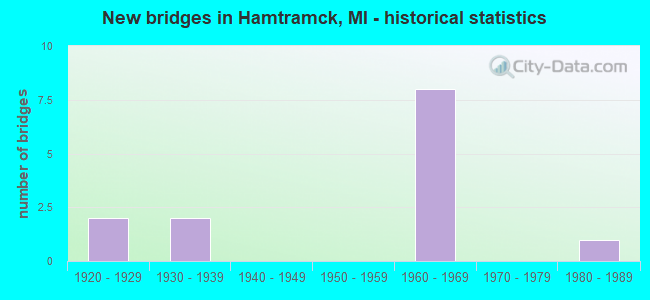
- New bridges - historical statistics
- 21920-1929
- 21930-1939
- 81960-1969
- 11980-1989

- Reconstructed bridges - Historical Statistics
- 11990-1999
- 32000-2009


- Bridge Condition - Superstructure
- 50.0%Good
- 50.0%Satisfactory

- Bridge Condition - Substructure
- 75.0%Good
- 25.0%Satisfactory
Find on map >> Show street view
Structure Number: 11853, Location: IN HAMTRAMCK (Lat: 42.395453, Lng: -83.068131), Route carried "on" structure: City street 2057, Year Built: 1969, Year Reconstructed: 2007, Status: Open, Structure Length: 6.58m (21.59ft), Average Daily Traffic: 6,000 (year 0000), Truck Traffic: 3%, Average Future Daily Traffic: 1,030 (year 2028), Design Load: HS 20, Features Intersected: I-75, Facility Carried by Structure: DEQUINDRE AVE
Minimum Vertical Clearance: 30.48m (100.00ft), Kilometerpoint: 0.452, Lanes on structure: 2, Lanes under structure: 8, Owner: State Highway Agency, Approaching Roadway Width: 8.6m (28.2ft), Skew: 4 degrees, Material/Design: Steel, Design/Construction: Stringer/Multi-beam, Number Of Spans In Main Unit: 2, Length of Maximum Span: 32.0m (105.0ft), Curb or Sidewalk Widths: Left: 0.0m, Right: 2.4m (7.9ft), Curb-To-Curb Width: 8.6m (28.2ft), Out-to-Out Width: 11.9m (39.0ft)
Condition: Deck: Very good, Superstructure: Good, Substructure: Good, Operating Rating: 54.8 metric tons, Method Used To Determine Operating Rating: Load Factor (LF) rating reported by rating factor (RF) method using MS18 loading, Inventory Rating: 32.7 metric tons, Method Used To Determine Inventory Rating: Load Factor (LF) rating reported by rating factor (RF) method using MS18 loading, Structural Evaluation: Better than present minimum criteria, Deck Geometry: Meets minimum limits, Underclear: Somewhat better than minimum adequacy, Approach Roadway Alignment: Equal to present desirable criteria, Designated Inspection Frequency: Every 24 months, Inspection Date: May 2020, Deck Structure Type: Concrete Cast-file-Place, Wearing Surface/Protective System: Wearing Surface: Monolithic Concrete, Deck Protection: Epoxy Coated Reinforcing
Find on map >> Show street view
Structure Number: 11854, Location: IN HAMTRAMCK (Lat: 42.396706, Lng: -83.068267), Route carried "on" structure: City street 2057, Year Built: 1969, Year Reconstructed: 2007, Status: Open, Structure Length: 4.86m (15.94ft), Average Daily Traffic: 10,500 (year 1978), Truck Traffic: 3%, Average Future Daily Traffic: 17,260 (year 2028), Design Load: HS 20, Features Intersected: I-75, Facility Carried by Structure: CANIFF AVE & TURN
Minimum Vertical Clearance: 30.48m (100.00ft), Kilometerpoint: 0.859, Lanes on structure: 6, Lanes under structure: 8, Owner: State Highway Agency, Approaching Roadway Width: 23.9m (78.4ft), Skew: 31 degrees, Material/Design: Steel, Design/Construction: Stringer/Multi-beam, Number Of Spans In Main Unit: 2, Length of Maximum Span: 24.5m (80.4ft), Curb or Sidewalk Widths: Left: 3.0m (9.8ft), Right: 0.0m, Curb-To-Curb Width: 23.9m (78.4ft), Out-to-Out Width: 30.8m (101.0ft)
Condition: Deck: Very good, Superstructure: Satisfactory, Substructure: Good, Operating Rating: 76.0 metric tons, Method Used To Determine Operating Rating: Load Factor (LF), Inventory Rating: 45.6 metric tons, Method Used To Determine Inventory Rating: Load Factor (LF), Structural Evaluation: Equal to present minimum criteria, Deck Geometry: Somewhat better than minimum adequacy, Underclear: High priority of corrective action, Approach Roadway Alignment: Equal to present desirable criteria, Designated Inspection Frequency: Every 24 months, Inspection Date: April 2020, Deck Structure Type: Concrete Cast-file-Place, Wearing Surface/Protective System: Wearing Surface: Monolithic Concrete, Deck Protection: Epoxy Coated Reinforcing
Find on map >> Show street view
Structure Number: 11855, Location: IN HAMTRAMCK (Lat: 42.401178, Lng: -83.071033), Route carried "on" structure: City street , Year Built: 1969, Year Reconstructed: 2007, Status: Open, Structure Length: 5.36m (17.59ft), Average Daily Traffic: 10,500 (year 1978), Truck Traffic: 3%, Average Future Daily Traffic: 2,050 (year 2028), Design Load: HS 20, Features Intersected: I-75, Facility Carried by Structure: COMMER AVE
Minimum Vertical Clearance: 30.48m (100.00ft), Kilometerpoint: 0.309, Lanes on structure: 4, Lanes under structure: 10, Owner: State Highway Agency, Approaching Roadway Width: 14.6m (47.9ft), Material/Design: Steel continuous, Design/Construction: Stringer/Multi-beam, Number Of Spans In Main Unit: 2, Length of Maximum Span: 26.8m (87.9ft), Curb or Sidewalk Widths: Left: 3.0m (9.8ft), Right: 3.0m (9.8ft), Curb-To-Curb Width: 14.6m (47.9ft), Out-to-Out Width: 21.5m (70.5ft)
Condition: Deck: Very good, Superstructure: Good, Substructure: Satisfactory, Operating Rating: 61.6 metric tons, Method Used To Determine Operating Rating: Load Factor (LF) rating reported by rating factor (RF) method using MS18 loading, Inventory Rating: 36.9 metric tons, Method Used To Determine Inventory Rating: Load Factor (LF) rating reported by rating factor (RF) method using MS18 loading, Structural Evaluation: Equal to present minimum criteria, Deck Geometry: High priority of replacement, Underclear: High priority of corrective action, Approach Roadway Alignment: Equal to present desirable criteria, Designated Inspection Frequency: Every 24 months, Inspection Date: April 2020, Deck Structure Type: Concrete Cast-file-Place, Wearing Surface/Protective System: Wearing Surface: Monolithic Concrete, Deck Protection: Epoxy Coated Reinforcing
Find on map >> Show street view
Structure Number: 11856, Location: IN HAMTRAMCK (Lat: 42.403194, Lng: -83.072400), Route carried "on" structure: City street , Year Built: 1969, Year Reconstructed: 2003, Status: Open, Structure Length: 6.18m (20.28ft), Average Daily Traffic: 15,976 (year 2010), Truck Traffic: 3%, Average Future Daily Traffic: 17,574 (year 2025), Design Load: HS 20, Features Intersected: I-75, Facility Carried by Structure: CARPENTER AVE
Minimum Vertical Clearance: 30.48m (100.00ft), Kilometerpoint: 0.076, Lanes on structure: 2, Lanes under structure: 10, Owner: State Highway Agency, Approaching Roadway Width: 8.5m (27.9ft), Skew: 3 degrees, Material/Design: Steel, Design/Construction: Stringer/Multi-beam, Number Of Spans In Main Unit: 2, Length of Maximum Span: 31.1m (102.0ft), Curb or Sidewalk Widths: Left: 2.4m (7.9ft), Right: 0.7m (2.3ft), Curb-To-Curb Width: 8.7m (28.5ft), Out-to-Out Width: 12.3m (40.4ft)
Condition: Deck: Very good, Superstructure: Satisfactory, Substructure: Good, Operating Rating: 76.8 metric tons, Method Used To Determine Operating Rating: Load Factor (LF) rating reported by rating factor (RF) method using MS18 loading, Inventory Rating: 46.0 metric tons, Method Used To Determine Inventory Rating: Load Factor (LF) rating reported by rating factor (RF) method using MS18 loading, Structural Evaluation: Equal to present minimum criteria, Deck Geometry: Meets minimum limits, Underclear: High priority of corrective action, Approach Roadway Alignment: Equal to present minimum criteria, Designated Inspection Frequency: Every 24 months, Inspection Date: April 2020, Deck Structure Type: Concrete Cast-file-Place, Wearing Surface/Protective System: Wearing Surface: Monolithic Concrete, Deck Protection: Epoxy Coated Reinforcing
Find on map >> Show street view
Structure Number: 11853, Location: IN HAMTRAMCK (Lat: 42.395453, Lng: -83.068131), Route carried "under" structure: Interstate 75, Year Built: 1969, Structure Length: 0. m, Average Daily Traffic: 143,588 (year 2007), Truck Traffic: 8%, Features Intersected: I-75, Facility Carried by Structure: DEQUINDRE AVE
Minimum Vertical Clearance: 5.69m (18.67ft), Kilometerpoint: 8.243, Lanes on structure: 2, Lanes under structure: 8, Material/Design: Steel, Design/Construction: Stringer/Multi-beam, Length of Maximum Span: 32.0m (105.0ft)
Find on map >> Show street view
Structure Number: 11854, Location: IN HAMTRAMCK (Lat: 42.396706, Lng: -83.068267), Route carried "under" structure: Interstate 75, Year Built: 1969, Structure Length: 0. m, Average Daily Traffic: 159,874 (year 2007), Truck Traffic: 8%, Features Intersected: I-75, Facility Carried by Structure: CANIFF AVE & TURN
Minimum Vertical Clearance: 5.61m (18.41ft), Kilometerpoint: 8.383, Lanes on structure: 6, Lanes under structure: 8, Material/Design: Steel, Design/Construction: Stringer/Multi-beam, Length of Maximum Span: 24.5m (80.4ft)
Find on map >> Show street view
Structure Number: 11855, Location: IN HAMTRAMCK (Lat: 42.401178, Lng: -83.071033), Route carried "under" structure: Interstate 75, Year Built: 1969, Structure Length: 0. m, Average Daily Traffic: 159,874 (year 2007), Truck Traffic: 8%, Features Intersected: I-75, Facility Carried by Structure: COMMER AVE
Minimum Vertical Clearance: 4.57m (14.99ft), Kilometerpoint: 8.931, Lanes on structure: 4, Lanes under structure: 10, Material/Design: Steel continuous, Design/Construction: Stringer/Multi-beam, Length of Maximum Span: 26.8m (87.9ft)
Find on map >> Show street view
Structure Number: 11856, Location: IN HAMTRAMCK (Lat: 42.403194, Lng: -83.072400), Route carried "under" structure: Interstate 75, Year Built: 1969, Structure Length: 0. m, Average Daily Traffic: 159,874 (year 2007), Truck Traffic: 8%, Features Intersected: I-75, Facility Carried by Structure: CARPENTER AVE
Minimum Vertical Clearance: 4.57m (14.99ft), Kilometerpoint: 9.180, Lanes on structure: 2, Lanes under structure: 10, Material/Design: Steel, Design/Construction: Stringer/Multi-beam, Length of Maximum Span: 31.1m (102.0ft)
Find on map >> Show street view
Structure Number: 12242, Location: HAMTRMCK N/HAMTRCK DRIVE (Lat: 42.386936, Lng: -83.051336), Route carried "under" structure: County highway 2057, Year Built: 1928, Structure Length: 0. m, Average Daily Traffic: 6,985 (year 1996), Truck Traffic: 5%, Features Intersected: JOSEPH CAMPAU, Facility Carried by Structure: GTW RR
Minimum Vertical Clearance: 4.29m (14.07ft), Kilometerpoint: 0.113, Lanes under structure: 4, Material/Design: Steel, Design/Construction: Stringer/Multi-beam, Length of Maximum Span: 10.9m (35.8ft)
Find on map >> Show street view
Structure Number: 12243, Location: HAMTRMCK N/HAMTRCK DRIVE (Lat: 42.387150, Lng: -83.051464), Route carried "under" structure: County highway 2057, Year Built: 1928, Structure Length: 0. m, Average Daily Traffic: 6,985 (year 1996), Truck Traffic: 5%, Features Intersected: JOSEPH CAMPAU, Facility Carried by Structure: CONRAIL
Minimum Vertical Clearance: 4.27m (14.01ft), Kilometerpoint: 0.138, Lanes under structure: 4, Material/Design: Steel, Design/Construction: Girder and Floorbeam System, Length of Maximum Span: 10.9m (35.8ft)
Find on map >> Show street view
Structure Number: 12244, Location: HAMTRAMCK S/HOLBROOK (Lat: 42.393447, Lng: -83.046408), Route carried "under" structure: County highway 2507, Year Built: 1937, Structure Length: 0. m, Average Daily Traffic: 13,614 (year 1996), Truck Traffic: 5%, Features Intersected: CONANT AVENUE, Facility Carried by Structure: GTW RR
Minimum Vertical Clearance: 4.39m (14.40ft), Kilometerpoint: 1.033, Lanes under structure: 6, Material/Design: Steel, Design/Construction: Girder and Floorbeam System, Length of Maximum Span: 15.2m (49.9ft)
Find on map >> Show street view
Structure Number: 12245, Location: HAMTRAMCK S/HOLBROOK (Lat: 42.393594, Lng: -83.046508), Route carried "under" structure: County highway 2507, Year Built: 1936, Structure Length: 0. m, Average Daily Traffic: 13,614 (year 1996), Truck Traffic: 5%, Features Intersected: CONANT AVENUE, Facility Carried by Structure: CONRAIL
Minimum Vertical Clearance: 4.37m (14.34ft), Kilometerpoint: 1.051, Lanes under structure: 6, Material/Design: Steel, Design/Construction: Girder and Floorbeam System, Length of Maximum Span: 15.2m (49.9ft)
Find on map >> Show street view
Structure Number: 12246, Location: HAMTRMCK W/JOS CAMPAU (Lat: 42.383153, Lng: -83.053531), Route carried "under" structure: County highway 2057, Year Built: 1983, Structure Length: 0. m, Average Daily Traffic: 4,445 (year 1992), Truck Traffic: 5%, Features Intersected: HAMTRAMCK DRIVE, Facility Carried by Structure: CONRAIL
Minimum Vertical Clearance: 4.60m (15.09ft), Kilometerpoint: 0.731, Lanes under structure: 4, Material/Design: Steel, Design/Construction: Girder and Floorbeam System, Length of Maximum Span: 39.0m (128.0ft)