Bridge Statistics for Green, Oregon (OR)
Condition, Traffic, Stress, Structural Evaluation, Project Costs
- National Bridge Inventory (NBI) Statistics
- 33Number of bridges
- 456ft / 139mTotal length
- $1,050,000Total costs
- 497,668Total average daily traffic
- 116,513Total average daily truck traffic
- National Bridge Inventory (NBI) Registered Bridges for Green
- No street view available for this location
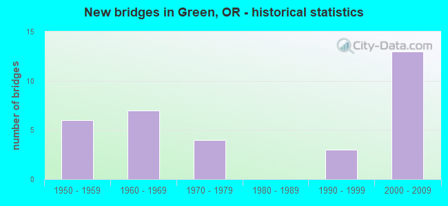
- New bridges - historical statistics
- 61950-1959
- 71960-1969
- 41970-1979
- 31990-1999
- 132000-2009


- Bridge Condition - Deck
- 31.8%Good
- 63.6%Satisfactory
- 4.5%Fair

- Bridge Condition - Superstructure
- 13.6%Very good
- 36.4%Good
- 45.5%Satisfactory
- 4.5%Fair

- Bridge Condition - Substructure
- 4.5%Very good
- 40.9%Good
- 45.5%Satisfactory
- 9.1%Fair

- Bridge Condition - Channel
- 7.7%Very good
- 38.5%Good
- 38.5%Satisfactory
- 15.4%Fair
Find on map >> Show street view
Structure Number: 1923A035 07447, Location: 02.7 MI W HWY 001 JCT (Lat: 43.133789, Lng: -123.399047), Route carried "on" structure: State highway 42, Year Built: 1976, Status: Open, Structure Length: 17.13m (56.20ft), Average Daily Traffic: 8,906 (year 2020), Truck Traffic: 7%, Average Future Daily Traffic: 13,750 (year 2040), Design Load: HS 20, Features Intersected: WB S.UMPQUA RV (WINSTON)
Minimum Vertical Clearance: 30+ m (98+ ft), Kilometerpoint: 119.848, Lanes on structure: 2, Base Highway Network: Yes, Owner: State Highway Agency, Approaching Roadway Width: 12.2m (40.0ft), Skew: 1 degrees, Material/Design: Prestressed concrete continuous, Design/Construction: Stringer/Multi-beam, Number Of Spans In Main Unit: 3, Number Of Approach Spans: 2, Length of Maximum Span: 55.5m (182.1ft), Curb or Sidewalk Widths: Left: 2.4m (7.9ft), Right: 0.0m, Curb-To-Curb Width: 12.2m (40.0ft), Out-to-Out Width: 15.8m (51.8ft)
Condition: Deck: Good, Superstructure: Very good, Substructure: Good, Channel: Good, Operating Rating: 31.8 metric tons, Method Used To Determine Operating Rating: Load and Resistance Factor Rating (LRFR) rating reported by rating factor(RF) method using HL-93 loadings, Inventory Rating: 24.3 metric tons, Method Used To Determine Inventory Rating: Load and Resistance Factor Rating (LRFR) rating reported by rating factor(RF) method using HL-93 loadings, Structural Evaluation: Equal to present minimum criteria, Deck Geometry: Better than present minimum criteria, Waterway Adequacy: Equal to present desirable criteria, Approach Roadway Alignment: Equal to present desirable criteria, Designated Inspection Frequency: Every 24 months, Underwater Inspection Frequency: Every 60 months, Inspection Date: April 2020, Underwater Inspection Date: July 2018, Deck Structure Type: Concrete Cast-file-Place, Wearing Surface/Protective System: Wearing Surface: Bituminous
Find on map >> Show street view
Structure Number: 2173A035 07602, Location: 012 MI NW HWY 1 JCT (Lat: 43.147708, Lng: -123.376014), Route carried "on" structure: State highway 42, Year Built: 1976, Status: Open, Structure Length: 11.28m (37.01ft), Average Daily Traffic: 21,979 (year 2020), Truck Traffic: 7%, Average Future Daily Traffic: 27,500 (year 2040), Design Load: HS 20, Features Intersected: CORP
Minimum Vertical Clearance: 30+ m (98+ ft), Kilometerpoint: 122.294, Lanes on structure: 5, Base Highway Network: Yes, Owner: State Highway Agency, Approaching Roadway Width: 26.2m (86.0ft), Skew: 4 degrees, Material/Design: Prestressed concrete continuous, Design/Construction: Stringer/Multi-beam, Number Of Spans In Main Unit: 4, Length of Maximum Span: 29.0m (95.1ft), Curb or Sidewalk Widths: Left: 2.4m (7.9ft), Right: 0.0m, Curb-To-Curb Width: 26.2m (86.0ft), Out-to-Out Width: 30.0m (98.4ft)
Condition: Deck: Satisfactory, Superstructure: Good, Substructure: Satisfactory, Channel: Good, Operating Rating: 31.4 metric tons, Method Used To Determine Operating Rating: Load and Resistance Factor Rating (LRFR) rating reported by rating factor(RF) method using HL-93 loadings, Inventory Rating: 24.3 metric tons, Method Used To Determine Inventory Rating: Load and Resistance Factor Rating (LRFR) rating reported by rating factor(RF) method using HL-93 loadings, Structural Evaluation: Equal to present minimum criteria, Deck Geometry: Superior to present desirable criteria, Underclear: Equal to present desirable criteria, Waterway Adequacy: Equal to present desirable criteria, Approach Roadway Alignment: Equal to present desirable criteria, Designated Inspection Frequency: Every 24 months, Inspection Date: April 2020, Deck Structure Type: Concrete Cast-file-Place, Wearing Surface/Protective System: Wearing Surface: Monolithic Concrete
Find on map >> Show street view
Structure Number: 7804N001 12003, Location: HWY 001 OVER SPEEDWAY RD (Lat: 43.160522, Lng: -123.365311), Route carried "on" structure: Interstate 5, Year Built: 1955, Status: Open, Structure Length: 3.35m (10.99ft), Average Daily Traffic: 41,586 (year 2020), Truck Traffic: 31%, Average Future Daily Traffic: 54,900 (year 2040), Design Load: HS 20, Features Intersected: I-5 @ SPEEDWAY RD
Minimum Vertical Clearance: 30+ m (98+ ft), Kilometerpoint: 193.170, Lanes on structure: 5, Lanes under structure: 2, Base Highway Network: Yes, Owner: State Highway Agency, Approaching Roadway Width: 33.5m (109.9ft), Skew: 30 degrees, Material/Design: Concrete continuous, Design/Construction: Slab, Number Of Spans In Main Unit: 3, Length of Maximum Span: 13.4m (44.0ft), Curb-To-Curb Width: 33.5m (109.9ft), Out-to-Out Width: 35.0m (114.8ft)
Condition: Deck: Good, Superstructure: Satisfactory, Substructure: Satisfactory, Operating Rating: 50.8 metric tons, Method Used To Determine Operating Rating: Load Factor (LF), Inventory Rating: 29.9 metric tons, Method Used To Determine Inventory Rating: Load Factor (LF), Structural Evaluation: Equal to present minimum criteria, Deck Geometry: Superior to present desirable criteria, Underclear: Equal to present minimum criteria, Approach Roadway Alignment: Equal to present desirable criteria, Designated Inspection Frequency: Every 24 months, Inspection Date: Febuary 2021, Deck Structure Type: Concrete Cast-file-Place, Wearing Surface/Protective System: Wearing Surface: Bituminous
Find on map >> Show street view
Structure Number: 7824 001 11918, Location: 04.8 MI S OF ROSEBURG SCL (Lat: 43.148139, Lng: -123.364839), Route carried "on" structure: County highway , Year Built: 1956, Status: Open, Structure Length: 6.58m (21.59ft), Average Daily Traffic: 15,294 (year 2020), Truck Traffic: 27%, Average Future Daily Traffic: 17,900 (year 2040), Design Load: HS 20, Features Intersected: I-5, (HWY 001), Facility Carried by Structure: GRANT SMITH ROAD
Minimum Vertical Clearance: 30+ m (98+ ft), Kilometerpoint: 0.000, Lanes on structure: 2, Lanes under structure: 4, Owner: State Highway Agency, Approaching Roadway Width: 7.9m (25.9ft), Skew: 3 degrees, Material/Design: Concrete continuous, Design/Construction: Tee Beam, Number Of Spans In Main Unit: 4, Length of Maximum Span: 18.3m (60.0ft), Curb-To-Curb Width: 7.9m (25.9ft), Out-to-Out Width: 9.4m (30.8ft)
Condition: Deck: Satisfactory, Superstructure: Fair, Substructure: Satisfactory, Operating Rating: 39.0 metric tons, Method Used To Determine Operating Rating: Load Factor (LF), Inventory Rating: 23.6 metric tons, Method Used To Determine Inventory Rating: Load Factor (LF), Structural Evaluation: Somewhat better than minimum adequacy, Deck Geometry: High priority of corrective action, Underclear: Meets minimum limits, Approach Roadway Alignment: Equal to present desirable criteria, Designated Inspection Frequency: Every 24 months, Inspection Date: January 2021, Deck Structure Type: Concrete Cast-file-Place, Wearing Surface/Protective System: Wearing Surface: Bituminous
Find on map >> Show street view
Structure Number: 7839 001 11344, Location: 10.5 MI S OF ROSEBURG SCL (Lat: 43.074031, Lng: -123.358331), Route carried "on" structure: Interstate 5, Year Built: 1956, Year Reconstructed: 1995, Status: Open, Structure Length: 4.42m (14.50ft), Average Daily Traffic: 11,913 (year 2020), Truck Traffic: 33%, Average Future Daily Traffic: 13,600 (year 2040), Design Load: HS 20, Features Intersected: CLARKS BRANCH RD
Minimum Vertical Clearance: 30+ m (98+ ft), Kilometerpoint: 182.564, Lanes on structure: 2, Lanes under structure: 2, Base Highway Network: Yes, Owner: State Highway Agency, Approaching Roadway Width: 12.8m (42.0ft), Skew: 3 degrees, Material/Design: Concrete continuous, Design/Construction: Tee Beam, Number Of Spans In Main Unit: 3, Length of Maximum Span: 16.5m (54.1ft), Curb-To-Curb Width: 12.8m (42.0ft), Out-to-Out Width: 13.6m (44.6ft)
Condition: Deck: Satisfactory, Superstructure: Satisfactory, Substructure: Satisfactory, Operating Rating: 34.5 metric tons, Method Used To Determine Operating Rating: Load Factor (LF), Inventory Rating: 20.9 metric tons, Method Used To Determine Inventory Rating: Load Factor (LF), Structural Evaluation: Somewhat better than minimum adequacy, Deck Geometry: Equal to present desirable criteria, Underclear: Somewhat better than minimum adequacy, Approach Roadway Alignment: Equal to present desirable criteria, Designated Inspection Frequency: Every 24 months, Inspection Date: January 2021, Deck Structure Type: Concrete Cast-file-Place, Wearing Surface/Protective System: Wearing Surface: Epoxy Overlay
Find on map >> Show street view
Structure Number: 7839A001 11344, Location: 10.5 MI S OF ROSEBURG SCL (Lat: 43.074050, Lng: -123.357939), Route carried "on" structure: Interstate 5, Year Built: 1964, Year Reconstructed: 1995, Status: Open, Structure Length: 3.81m (12.50ft), Average Daily Traffic: 11,913 (year 2020), Truck Traffic: 33%, Average Future Daily Traffic: 13,600 (year 2040), Design Load: HS 20, Features Intersected: CLARKS BRANCH RD
Minimum Vertical Clearance: 30+ m (98+ ft), Kilometerpoint: 182.564, Lanes on structure: 2, Lanes under structure: 2, Base Highway Network: Yes, Owner: State Highway Agency, Approaching Roadway Width: 11.7m (38.4ft), Skew: 3 degrees, Material/Design: Concrete continuous, Design/Construction: Slab, Number Of Spans In Main Unit: 3, Length of Maximum Span: 15.2m (49.9ft), Curb-To-Curb Width: 11.7m (38.4ft), Out-to-Out Width: 12.8m (42.0ft)
Condition: Deck: Satisfactory, Superstructure: Satisfactory, Substructure: Satisfactory, Operating Rating: 34.5 metric tons, Method Used To Determine Operating Rating: Load Factor (LF), Inventory Rating: 20.9 metric tons, Method Used To Determine Inventory Rating: Load Factor (LF), Structural Evaluation: Somewhat better than minimum adequacy, Deck Geometry: Equal to present minimum criteria, Underclear: Somewhat better than minimum adequacy, Approach Roadway Alignment: Equal to present desirable criteria, Designated Inspection Frequency: Every 24 months, Inspection Date: January 2021, Deck Structure Type: Concrete Cast-file-Place, Wearing Surface/Protective System: Wearing Surface: Bituminous
Find on map >> Show street view
Structure Number: 18399 000 00067, Location: T28S-R6W-S3 (Lat: 43.160711, Lng: -123.395589), Route carried "on" structure: County highway A0849, Year Built: 1996, Status: Open, Structure Length: 14.05m (46.10ft), Average Daily Traffic: 1,886 (year 2020), Truck Traffic: 10%, Average Future Daily Traffic: 2,131 (year 2025), Design Load: HS 20, Features Intersected: SOUTH UMPQUA RIVER, Facility Carried by Structure: HAPPY VALLEY RD.
Minimum Vertical Clearance: 30+ m (98+ ft), Kilometerpoint: 1.078, Lanes on structure: 2, Owner: County Highway Agency, Approaching Roadway Width: 12.2m (40.0ft), Material/Design: Steel continuous, Design/Construction: Box Beam or Girders - Multiple, Number Of Spans In Main Unit: 3, Length of Maximum Span: 51.8m (169.9ft), Curb-To-Curb Width: 12.2m (40.0ft), Out-to-Out Width: 13.0m (42.7ft)
Condition: Deck: Satisfactory, Superstructure: Good, Substructure: Good, Channel: Very good, Operating Rating: 50.5 metric tons, Method Used To Determine Operating Rating: Load and Resistance Factor Rating (LRFR) rating reported by rating factor(RF) method using HL-93 loadings, Inventory Rating: 38.9 metric tons, Method Used To Determine Inventory Rating: Load and Resistance Factor Rating (LRFR) rating reported by rating factor(RF) method using HL-93 loadings, Structural Evaluation: Better than present minimum criteria, Deck Geometry: Better than present minimum criteria, Waterway Adequacy: Equal to present desirable criteria, Approach Roadway Alignment: Better than present minimum criteria, Designated Inspection Frequency: Every 24 months, Underwater Inspection Frequency: Every 60 months, Inspection Date: July 2021, Underwater Inspection Date: July 2018, Deck Structure Type: Concrete Cast-file-Place, Wearing Surface/Protective System: Wearing Surface: Monolithic Concrete, Deck Protection: Epoxy Coated Reinforcing
Find on map >> Show street view
Structure Number: 19738 001 12057, Location: 03.4 MI S OF ROSEBURG SCL (Lat: 43.169100, Lng: -123.366900), Route carried "on" structure: Interstate 5, Year Built: 2006, Status: Open, Structure Length: 29.00m (95.14ft), Average Daily Traffic: 20,495 (year 2020), Truck Traffic: 31%, Average Future Daily Traffic: 29,600 (year 2040), Design Load: HL 93, Features Intersected: S UMPQUA R & CORP
Minimum Vertical Clearance: 30+ m (98+ ft), Kilometerpoint: 194.039, Lanes on structure: 2, Base Highway Network: Yes, Owner: State Highway Agency, Approaching Roadway Width: 18.0m (59.1ft), Material/Design: Prestressed concrete continuous, Design/Construction: Box Beam or Girders - Multiple, Number Of Spans In Main Unit: 4, Length of Maximum Span: 83.0m (272.3ft), Curb-To-Curb Width: 18.0m (59.1ft), Out-to-Out Width: 18.9m (62.0ft)
Condition: Deck: Satisfactory, Superstructure: Satisfactory, Substructure: Satisfactory, Channel: Good, Operating Rating: 48.3 metric tons, Method Used To Determine Operating Rating: Load and Resistance Factor Rating (LRFR) rating reported by rating factor(RF) method using HL-93 loadings, Inventory Rating: 37.3 metric tons, Method Used To Determine Inventory Rating: Load and Resistance Factor Rating (LRFR) rating reported by rating factor(RF) method using HL-93 loadings, Structural Evaluation: Equal to present minimum criteria, Deck Geometry: Superior to present desirable criteria, Underclear: Equal to present desirable criteria, Waterway Adequacy: Superior to present desirable criteria, Approach Roadway Alignment: Equal to present desirable criteria, Designated Inspection Frequency: Every 24 months, Underwater Inspection Frequency: Every 60 months, Inspection Date: Febuary 2021, Underwater Inspection Date: June 2021, Deck Structure Type: Concrete Cast-file-Place, Wearing Surface/Protective System: Wearing Surface: Monolithic Concrete
Find on map >> Show street view
Structure Number: 19740 001 12049, Location: 03.5 MI S OF ROSEBURG SCL (Lat: 43.167500, Lng: -123.366150), Route carried "on" structure: Interstate 5, Year Built: 2007, Status: Open, Structure Length: 3.13m (10.27ft), Average Daily Traffic: 20,495 (year 2020), Truck Traffic: 31%, Average Future Daily Traffic: 29,600 (year 2040), Design Load: HL 93, Features Intersected: I-5 @ HWY 234
Minimum Vertical Clearance: 30+ m (98+ ft), Kilometerpoint: 193.910, Lanes on structure: 2, Lanes under structure: 2, Base Highway Network: Yes, Owner: State Highway Agency, Approaching Roadway Width: 18.0m (59.1ft), Skew: 5 degrees, Material/Design: Prestressed concrete, Design/Construction: Stringer/Multi-beam, Number Of Spans In Main Unit: 1, Length of Maximum Span: 31.3m (102.7ft), Curb-To-Curb Width: 18.0m (59.1ft), Out-to-Out Width: 18.8m (61.7ft)
Condition: Deck: Satisfactory, Superstructure: Very good, Substructure: Good, Operating Rating: 31.1 metric tons, Method Used To Determine Operating Rating: Load and Resistance Factor Rating (LRFR) rating reported by rating factor(RF) method using HL-93 loadings, Inventory Rating: 24.0 metric tons, Method Used To Determine Inventory Rating: Load and Resistance Factor Rating (LRFR) rating reported by rating factor(RF) method using HL-93 loadings, Structural Evaluation: Somewhat better than minimum adequacy, Deck Geometry: Superior to present desirable criteria, Underclear: Somewhat better than minimum adequacy, Approach Roadway Alignment: Equal to present desirable criteria, Designated Inspection Frequency: Every 24 months, Inspection Date: Febuary 2021, Deck Structure Type: Concrete Cast-file-Place, Wearing Surface/Protective System: Wearing Surface: Monolithic Concrete
Find on map >> Show street view
Structure Number: 19741 001 12049, Location: 03.5 MI S OF ROSEBURG SCL (Lat: 43.167042, Lng: -123.366219), Route carried "on" structure: Interstate 5, Year Built: 2007, Status: Open, Structure Length: 3.13m (10.27ft), Average Daily Traffic: 20,495 (year 2020), Truck Traffic: 31%, Average Future Daily Traffic: 29,600 (year 2040), Design Load: HL 93, Features Intersected: I-5 @ HWY 234
Minimum Vertical Clearance: 30+ m (98+ ft), Kilometerpoint: 193.910, Lanes on structure: 2, Lanes under structure: 2, Base Highway Network: Yes, Owner: State Highway Agency, Approaching Roadway Width: 18.0m (59.1ft), Skew: 5 degrees, Material/Design: Prestressed concrete, Design/Construction: Stringer/Multi-beam, Number Of Spans In Main Unit: 1, Length of Maximum Span: 31.3m (102.7ft), Curb-To-Curb Width: 18.0m (59.1ft), Out-to-Out Width: 18.8m (61.7ft)
Condition: Deck: Satisfactory, Superstructure: Very good, Substructure: Good, Operating Rating: 31.4 metric tons, Method Used To Determine Operating Rating: Load and Resistance Factor Rating (LRFR) rating reported by rating factor(RF) method using HL-93 loadings, Inventory Rating: 24.3 metric tons, Method Used To Determine Inventory Rating: Load and Resistance Factor Rating (LRFR) rating reported by rating factor(RF) method using HL-93 loadings, Structural Evaluation: Equal to present minimum criteria, Deck Geometry: Superior to present desirable criteria, Underclear: Meets minimum limits, Approach Roadway Alignment: Equal to present desirable criteria, Designated Inspection Frequency: Every 24 months, Inspection Date: Febuary 2021, Deck Structure Type: Concrete Cast-file-Place, Wearing Surface/Protective System: Wearing Surface: Monolithic Concrete
Find on map >> Show street view
Structure Number: 19C159 16 1157, Location: 1.7 MI SE KELLEYS KORNER (Lat: 43.126906, Lng: -123.363086), Route carried "on" structure: County highway A392, Year Built: 1960, Status: Posted for load, Structure Length: 3.23m (10.60ft), Average Daily Traffic: 1,668 (year 2020), Truck Traffic: 5%, Average Future Daily Traffic: 1,888 (year 2025), Design Load: H 20, Features Intersected: ROBERTS CREEK, Facility Carried by Structure: COUNTY RD 16
Minimum Vertical Clearance: 30+ m (98+ ft), Kilometerpoint: 18.620, Lanes on structure: 2, Owner: County Highway Agency, Approaching Roadway Width: 7.9m (25.9ft), Skew: 4 degrees, Material/Design: Steel, Design/Construction: Stringer/Multi-beam, Number Of Spans In Main Unit: 3, Length of Maximum Span: 15.2m (49.9ft), Curb-To-Curb Width: 7.4m (24.3ft), Out-to-Out Width: 8.0m (26.2ft)
Condition: Deck: Fair, Superstructure: Satisfactory, Substructure: Satisfactory, Channel: Satisfactory, Operating Rating: 21.4 metric tons, Method Used To Determine Operating Rating: Load and Resistance Factor Rating (LRFR) rating reported by rating factor(RF) method using HL-93 loadings, Inventory Rating: 16.5 metric tons, Method Used To Determine Inventory Rating: Load and Resistance Factor Rating (LRFR) rating reported by rating factor(RF) method using HL-93 loadings, Structural Evaluation: Meets minimum limits, Deck Geometry: Meets minimum limits, Waterway Adequacy: Equal to present desirable criteria, Approach Roadway Alignment: Better than present minimum criteria, Bridge Posting: Required (Relationship of Operating Rating to Maximum Legal Load: 20.0 - 29.9% below), Designated Inspection Frequency: Every 24 months, Inspection Date: July 2021, Deck Structure Type: Concrete Cast-file-Place, Wearing Surface/Protective System: Wearing Surface: Bituminous
Find on map >> Show street view
Structure Number: 19C204011000004, Location: 0.5 MI N KELLEYS KORNER (Lat: 43.153300, Lng: -123.381100), Route carried "on" structure: County highway C0110, Year Built: 1968, Status: Open, Structure Length: 2.74m (8.99ft), Average Daily Traffic: 930 (year 2020), Truck Traffic: 5%, Average Future Daily Traffic: 1,050 (year 2025), Design Load: H 20, Features Intersected: ROBERTS CREEK, Facility Carried by Structure: COUNTY RD 110
Minimum Vertical Clearance: 30+ m (98+ ft), Kilometerpoint: 0.064, Lanes on structure: 2, Owner: County Highway Agency, Approaching Roadway Width: 12.5m (41.0ft), Skew: 3 degrees, Material/Design: Steel, Design/Construction: Stringer/Multi-beam, Number Of Spans In Main Unit: 1, Number Of Approach Spans: 2, Length of Maximum Span: 14.9m (48.9ft), Curb-To-Curb Width: 11.6m (38.1ft), Out-to-Out Width: 12.2m (40.0ft)
Condition: Deck: Good, Superstructure: Good, Substructure: Fair, Channel: Fair, Operating Rating: 34.5 metric tons, Method Used To Determine Operating Rating: Load Factor (LF), Inventory Rating: 20.9 metric tons, Method Used To Determine Inventory Rating: Load Factor (LF), Structural Evaluation: Somewhat better than minimum adequacy, Deck Geometry: Better than present minimum criteria, Waterway Adequacy: Equal to present minimum criteria, Approach Roadway Alignment: Equal to present desirable criteria, Designated Inspection Frequency: Every 24 months, Underwater Inspection Frequency: Every 60 months, Inspection Date: July 2021, Underwater Inspection Date: November 2020, Deck Structure Type: Concrete Cast-file-Place, Wearing Surface/Protective System: Wearing Surface: Bituminous
Find on map >> Show street view
Structure Number: 19C363 16 143, Location: 1.0 MI N OF KELLYS KORNER (Lat: 43.159800, Lng: -123.382100), Route carried "on" structure: County highway A392, Year Built: 1960, Status: Open, Structure Length: 3.11m (10.20ft), Average Daily Traffic: 1,008 (year 2020), Truck Traffic: 10%, Average Future Daily Traffic: 1,137 (year 2025), Design Load: H 20, Features Intersected: ROBERTS CREEK, Facility Carried by Structure: COUNTY RD 16
Minimum Vertical Clearance: 30+ m (98+ ft), Kilometerpoint: 23.014, Lanes on structure: 2, Owner: County Highway Agency, Approaching Roadway Width: 10.7m (35.1ft), Skew: 1 degrees, Material/Design: Steel continuous, Design/Construction: Stringer/Multi-beam, Number Of Spans In Main Unit: 3, Length of Maximum Span: 12.2m (40.0ft), Curb or Sidewalk Widths: Left: 0.0m, Right: 1.5m (4.9ft), Curb-To-Curb Width: 8.3m (27.2ft), Out-to-Out Width: 10.3m (33.8ft)
Condition: Deck: Satisfactory, Superstructure: Satisfactory, Substructure: Fair, Channel: Satisfactory, Operating Rating: 67.1 metric tons, Method Used To Determine Operating Rating: Allowable Stress (AS), Inventory Rating: 39.9 metric tons, Method Used To Determine Inventory Rating: Allowable Stress (AS), Structural Evaluation: Somewhat better than minimum adequacy, Deck Geometry: Meets minimum limits, Waterway Adequacy: Equal to present desirable criteria, Approach Roadway Alignment: Equal to present desirable criteria, Designated Inspection Frequency: Every 24 months, Inspection Date: July 2021, Deck Structure Type: Concrete Cast-file-Place, Wearing Surface/Protective System: Wearing Surface: Bituminous
Find on map >> Show street view
Structure Number: 19C407 16 1221, Location: 1.1 MI SE KELLEYS KORNER (Lat: 43.132342, Lng: -123.372839), Route carried "on" structure: County highway A392, Year Built: 1969, Status: Open, Structure Length: 6.25m (20.51ft), Average Daily Traffic: 2,612 (year 2020), Truck Traffic: 5%, Average Future Daily Traffic: 2,952 (year 2025), Design Load: HS 20, Features Intersected: SPRR, Facility Carried by Structure: COUNTY RD 16
Minimum Vertical Clearance: 30+ m (98+ ft), Kilometerpoint: 19.650, Lanes on structure: 2, Lanes under structure: 2, Owner: County Highway Agency, Approaching Roadway Width: 10.4m (34.1ft), Skew: 2 degrees, Material/Design: Prestressed concrete, Design/Construction: Box Beam or Girders - Multiple, Number Of Spans In Main Unit: 1, Number Of Approach Spans: 2, Length of Maximum Span: 22.3m (73.2ft), Curb or Sidewalk Widths: Left: 0.6m (2.0ft), Right: 0.6m (2.0ft), Curb-To-Curb Width: 9.3m (30.5ft), Out-to-Out Width: 11.0m (36.1ft)
Condition: Deck: Good, Superstructure: Good, Substructure: Good, Operating Rating: 42.1 metric tons, Method Used To Determine Operating Rating: Load and Resistance Factor Rating (LRFR) rating reported by rating factor(RF) method using HL-93 loadings, Inventory Rating: 32.4 metric tons, Method Used To Determine Inventory Rating: Load and Resistance Factor Rating (LRFR) rating reported by rating factor(RF) method using HL-93 loadings, Structural Evaluation: Better than present minimum criteria, Deck Geometry: Meets minimum limits, Underclear: High priority of corrective action, Approach Roadway Alignment: Somewhat better than minimum adequacy, Length Of Structure Improvement: 6.20m (20.34ft), Designated Inspection Frequency: Every 24 months, Inspection Date: July 2021, Bridge Improvement Cost: $656,000, Roadway Improvement Cost: $66,000, Total Project Cost: $1,050,000, Deck Structure Type: Concrete Cast-file-Place, Wearing Surface/Protective System: Wearing Surface: Bituminous
Find on map >> Show street view
Structure Number: 19C421035700018, Location: 11.5 MI S OF ROSEBURG (Lat: 43.079761, Lng: -123.340578), Route carried "on" structure: County highway C0357, Year Built: 1979, Status: Open, Structure Length: 0.94m (3.08ft), Average Daily Traffic: 552 (year 2020), Truck Traffic: 3%, Average Future Daily Traffic: 622 (year 2025), Design Load: H 20, Features Intersected: CLARK BRANCH CR, Facility Carried by Structure: WAGONTIRE DR.
Minimum Vertical Clearance: 30+ m (98+ ft), Kilometerpoint: 0.290, Lanes on structure: 2, Owner: County Highway Agency, Approaching Roadway Width: 7.3m (24.0ft), Material/Design: Steel, Design/Construction: Stringer/Multi-beam, Number Of Spans In Main Unit: 1, Length of Maximum Span: 8.8m (28.9ft), Curb-To-Curb Width: 8.0m (26.2ft), Out-to-Out Width: 8.5m (27.9ft)
Condition: Deck: Good, Superstructure: Good, Substructure: Satisfactory, Channel: Fair, Operating Rating: 88.9 metric tons, Method Used To Determine Operating Rating: Load Factor (LF), Inventory Rating: 57.2 metric tons, Method Used To Determine Inventory Rating: Load Factor (LF), Structural Evaluation: Equal to present minimum criteria, Deck Geometry: Somewhat better than minimum adequacy, Waterway Adequacy: Equal to present desirable criteria, Approach Roadway Alignment: Equal to present desirable criteria, Designated Inspection Frequency: Every 24 months, Inspection Date: July 2021, Deck Structure Type: Concrete Cast-file-Place, Wearing Surface/Protective System: Wearing Surface: Bituminous
Find on map >> Show street view
Structure Number: 19C511207A00002, Location: 0.7 MI N KELLEYS KORNER (Lat: 43.156147, Lng: -123.381992), Route carried "on" structure: County highway C207A, Year Built: 1978, Status: Open, Structure Length: 1.92m (6.30ft), Average Daily Traffic: 1,717 (year 2020), Truck Traffic: 5%, Average Future Daily Traffic: 1,942 (year 2025), Design Load: HS 20, Features Intersected: ROBERTS CREEK, Facility Carried by Structure: COUNTY RD 207A
Minimum Vertical Clearance: 30+ m (98+ ft), Kilometerpoint: 0.032, Lanes on structure: 2, Owner: County Highway Agency, Approaching Roadway Width: 7.9m (25.9ft), Skew: 1 degrees, Material/Design: Prestressed concrete, Design/Construction: Slab, Number Of Spans In Main Unit: 1, Length of Maximum Span: 18.9m (62.0ft), Curb-To-Curb Width: 7.9m (25.9ft), Out-to-Out Width: 8.5m (27.9ft)
Condition: Deck: Satisfactory, Superstructure: Satisfactory, Substructure: Good, Channel: Satisfactory, Operating Rating: 62.6 metric tons, Method Used To Determine Operating Rating: Load Factor (LF), Inventory Rating: 34.5 metric tons, Method Used To Determine Inventory Rating: Load Factor (LF), Structural Evaluation: Equal to present minimum criteria, Deck Geometry: Meets minimum limits, Waterway Adequacy: Better than present minimum criteria, Approach Roadway Alignment: Equal to present desirable criteria, Designated Inspection Frequency: Every 24 months, Inspection Date: July 2021, Deck Structure Type: Other, Wearing Surface/Protective System: Wearing Surface: Bituminous
Find on map >> Show street view
Structure Number: 19C523 26 002, Location: 1 MILE N OF KELLYS KORNER (Lat: 43.159400, Lng: -123.381900), Route carried "on" structure: County highway A849, Year Built: 1992, Status: Open, Structure Length: 2.16m (7.09ft), Average Daily Traffic: 8,893 (year 2020), Truck Traffic: 10%, Average Future Daily Traffic: 9,643 (year 2025), Design Load: HS 25 or greater, Features Intersected: ROBERTS CREEK, Facility Carried by Structure: COUNTY RD 26C
Minimum Vertical Clearance: 30+ m (98+ ft), Kilometerpoint: 0.032, Lanes on structure: 3, Owner: County Highway Agency, Approaching Roadway Width: 16.2m (53.1ft), Skew: 1 degrees, Material/Design: Prestressed concrete, Design/Construction: Slab, Number Of Spans In Main Unit: 1, Length of Maximum Span: 21.3m (69.9ft), Curb or Sidewalk Widths: Left: 0.0m, Right: 1.6m (5.2ft), Curb-To-Curb Width: 14.5m (47.6ft), Out-to-Out Width: 17.1m (56.1ft)
Condition: Deck: Good, Superstructure: Good, Substructure: Very good, Channel: Satisfactory, Operating Rating: 63.5 metric tons, Method Used To Determine Operating Rating: Load Factor (LF), Inventory Rating: 38.1 metric tons, Method Used To Determine Inventory Rating: Load Factor (LF), Structural Evaluation: Better than present minimum criteria, Deck Geometry: Somewhat better than minimum adequacy, Waterway Adequacy: Equal to present desirable criteria, Approach Roadway Alignment: Equal to present desirable criteria, Designated Inspection Frequency: Every 24 months, Inspection Date: July 2021, Deck Structure Type: Other, Wearing Surface/Protective System: Wearing Surface: Bituminous
Find on map >> Show street view
Structure Number: 19C524395-00.07, Location: T28S-R6W-S11 (Lat: 43.148558, Lng: -123.379733), Route carried "on" structure: County highway 395, Year Built: 1993, Status: Open, Structure Length: 2.04m (6.69ft), Average Daily Traffic: 301 (year 2020), Truck Traffic: 10%, Average Future Daily Traffic: 340 (year 2025), Design Load: HS 25 or greater, Features Intersected: ROBERTS CREEK, Facility Carried by Structure: INDUSTRIAL DRIVE
Minimum Vertical Clearance: 30+ m (98+ ft), Kilometerpoint: 0.113, Lanes on structure: 2, Owner: County Highway Agency, Approaching Roadway Width: 11.6m (38.1ft), Material/Design: Prestressed concrete, Design/Construction: Slab, Number Of Spans In Main Unit: 1, Length of Maximum Span: 19.5m (64.0ft), Curb or Sidewalk Widths: Left: 0.0m, Right: 1.4m (4.6ft), Curb-To-Curb Width: 12.1m (39.7ft), Out-to-Out Width: 14.6m (47.9ft)
Condition: Deck: Good, Superstructure: Good, Substructure: Good, Channel: Satisfactory, Operating Rating: 79.8 metric tons, Method Used To Determine Operating Rating: Load Factor (LF), Inventory Rating: 48.1 metric tons, Method Used To Determine Inventory Rating: Load Factor (LF), Structural Evaluation: Better than present minimum criteria, Deck Geometry: Superior to present desirable criteria, Waterway Adequacy: Equal to present desirable criteria, Approach Roadway Alignment: Equal to present desirable criteria, Designated Inspection Frequency: Every 24 months, Inspection Date: July 2021, Deck Structure Type: Other, Wearing Surface/Protective System: Wearing Surface: Bituminous
Find on map >> Show street view
Structure Number: 20333 035 07665, Location: 005 MI NW HWY 1 JCT (Lat: 43.152931, Lng: -123.365008), Route carried "on" structure: State highway 42, Year Built: 2006, Status: Open, Structure Length: 6.10m (20.01ft), Average Daily Traffic: 21,979 (year 2020), Truck Traffic: 7%, Average Future Daily Traffic: 27,500 (year 2040), Design Load: HL 93, Features Intersected: I-5 (HWY 001)
Minimum Vertical Clearance: 30+ m (98+ ft), Kilometerpoint: 123.356, Lanes on structure: 2, Lanes under structure: 4, Base Highway Network: Yes, Owner: State Highway Agency, Approaching Roadway Width: 18.6m (61.0ft), Skew: 3 degrees, Material/Design: Prestressed concrete, Design/Construction: Box Beam or Girders - Multiple, Number Of Spans In Main Unit: 2, Length of Maximum Span: 30.5m (100.1ft), Curb-To-Curb Width: 18.6m (61.0ft), Out-to-Out Width: 19.5m (64.0ft)
Condition: Deck: Satisfactory, Superstructure: Satisfactory, Substructure: Satisfactory, Operating Rating: 72.6 metric tons, Method Used To Determine Operating Rating: Load Factor (LF), Inventory Rating: 43.5 metric tons, Method Used To Determine Inventory Rating: Load Factor (LF), Structural Evaluation: Equal to present minimum criteria, Deck Geometry: Superior to present desirable criteria, Underclear: Superior to present desirable criteria, Approach Roadway Alignment: Equal to present desirable criteria, Designated Inspection Frequency: Every 24 months, Inspection Date: April 2020, Deck Structure Type: Concrete Cast-file-Place, Wearing Surface/Protective System: Wearing Surface: Monolithic Concrete
Find on map >> Show street view
Structure Number: 20389 001 11774, Location: 06.1 MI S OF ROSEBURG SCL (Lat: 43.127561, Lng: -123.364350), Route carried "on" structure: Interstate 5, Year Built: 2006, Status: Open, Structure Length: 5.64m (18.50ft), Average Daily Traffic: 20,793 (year 2020), Truck Traffic: 31%, Average Future Daily Traffic: 27,450 (year 2040), Design Load: HL 93, Features Intersected: ROBERTS CREEK RD
Minimum Vertical Clearance: 30+ m (98+ ft), Kilometerpoint: 189.484, Lanes on structure: 2, Lanes under structure: 2, Base Highway Network: Yes, Owner: State Highway Agency, Approaching Roadway Width: 12.8m (42.0ft), Skew: 3 degrees, Material/Design: Prestressed concrete continuous, Design/Construction: Stringer/Multi-beam, Number Of Spans In Main Unit: 2, Length of Maximum Span: 35.1m (115.2ft), Curb-To-Curb Width: 12.8m (42.0ft), Out-to-Out Width: 13.7m (44.9ft)
Condition: Deck: Satisfactory, Superstructure: Satisfactory, Substructure: Satisfactory, Channel: Good, Operating Rating: 52.5 metric tons, Method Used To Determine Operating Rating: Load and Resistance Factor Rating (LRFR) rating reported by rating factor(RF) method using HL-93 loadings, Inventory Rating: 40.5 metric tons, Method Used To Determine Inventory Rating: Load and Resistance Factor Rating (LRFR) rating reported by rating factor(RF) method using HL-93 loadings, Structural Evaluation: Equal to present minimum criteria, Deck Geometry: Equal to present desirable criteria, Underclear: Meets minimum limits, Waterway Adequacy: Equal to present desirable criteria, Approach Roadway Alignment: Equal to present desirable criteria, Designated Inspection Frequency: Every 24 months, Inspection Date: January 2021, Deck Structure Type: Concrete Cast-file-Place, Wearing Surface/Protective System: Wearing Surface: Monolithic Concrete
Find on map >> Show street view
Structure Number: 20422 001 11774, Location: 06.2 MI S OF ROSEBURG SCL (Lat: 43.127350, Lng: -123.363961), Route carried "on" structure: Interstate 5, Year Built: 2006, Status: Open, Structure Length: 5.94m (19.49ft), Average Daily Traffic: 20,793 (year 2020), Truck Traffic: 31%, Average Future Daily Traffic: 27,450 (year 2040), Design Load: HL 93, Features Intersected: ROBERTS CREEK RD
Minimum Vertical Clearance: 30+ m (98+ ft), Kilometerpoint: 189.484, Lanes on structure: 2, Lanes under structure: 2, Base Highway Network: Yes, Owner: State Highway Agency, Approaching Roadway Width: 12.8m (42.0ft), Skew: 3 degrees, Material/Design: Prestressed concrete continuous, Design/Construction: Stringer/Multi-beam, Number Of Spans In Main Unit: 2, Length of Maximum Span: 30.5m (100.1ft), Curb-To-Curb Width: 12.8m (42.0ft), Out-to-Out Width: 13.7m (44.9ft)
Condition: Deck: Satisfactory, Superstructure: Satisfactory, Substructure: Good, Channel: Good, Operating Rating: 43.7 metric tons, Method Used To Determine Operating Rating: Load and Resistance Factor Rating (LRFR) rating reported by rating factor(RF) method using HL-93 loadings, Inventory Rating: 33.7 metric tons, Method Used To Determine Inventory Rating: Load and Resistance Factor Rating (LRFR) rating reported by rating factor(RF) method using HL-93 loadings, Structural Evaluation: Equal to present minimum criteria, Deck Geometry: Equal to present desirable criteria, Underclear: Meets minimum limits, Waterway Adequacy: Superior to present desirable criteria, Approach Roadway Alignment: Equal to present desirable criteria, Designated Inspection Frequency: Every 24 months, Inspection Date: January 2021, Deck Structure Type: Concrete Cast-file-Place, Wearing Surface/Protective System: Wearing Surface: Monolithic Concrete
Find on map >> Show street view
Structure Number: 21087 001 12169, Location: 02.3 MI S OF ROSEBURG SCL (Lat: 43.183322, Lng: -123.374097), Route carried "on" structure: Interstate 5, Year Built: 2009, Status: Open, Structure Length: 3.35m (10.99ft), Average Daily Traffic: 41,275 (year 2020), Truck Traffic: 31%, Average Future Daily Traffic: 60,000 (year 2040), Design Load: HL 93, Features Intersected: I-5 @ MCLAIN RD
Minimum Vertical Clearance: 30+ m (98+ ft), Kilometerpoint: 195.841, Lanes on structure: 5, Lanes under structure: 2, Base Highway Network: Yes, Owner: State Highway Agency, Approaching Roadway Width: 30.7m (100.7ft), Skew: 30 degrees, Material/Design: Prestressed concrete, Design/Construction: Slab, Number Of Spans In Main Unit: 3, Length of Maximum Span: 12.8m (42.0ft), Curb-To-Curb Width: 30.7m (100.7ft), Out-to-Out Width: 34.2m (112.2ft)
Condition: Deck: Satisfactory, Superstructure: Good, Substructure: Good, Operating Rating: 40.2 metric tons, Method Used To Determine Operating Rating: Load and Resistance Factor Rating (LRFR) rating reported by rating factor(RF) method using HL-93 loadings, Inventory Rating: 31.1 metric tons, Method Used To Determine Inventory Rating: Load and Resistance Factor Rating (LRFR) rating reported by rating factor(RF) method using HL-93 loadings, Structural Evaluation: Better than present minimum criteria, Deck Geometry: Superior to present desirable criteria, Underclear: Equal to present minimum criteria, Approach Roadway Alignment: Equal to present desirable criteria, Designated Inspection Frequency: Every 24 months, Inspection Date: Febuary 2021, Deck Structure Type: Concrete Cast-file-Place, Wearing Surface/Protective System: Wearing Surface: Monolithic Concrete
Find on map >> Show street view
Structure Number: 7804N001 12003, Location: HWY 001 OVER SPEEDWAY RD (Lat: 43.160522, Lng: -123.365311), Route carried "under" structure: County highway , Year Built: 1955, Structure Length: 0. m, Average Daily Traffic: 41,300 (year 2010), Truck Traffic: 17%, Features Intersected: I-5 @ SPEEDWAY RD, Facility Carried by Structure: I-5 (HWY 001)
Minimum Vertical Clearance: 4.75m (15.58ft), Kilometerpoint: 0.000, Lanes on structure: 5, Lanes under structure: 2, Material/Design: Concrete continuous, Design/Construction: Slab, Length of Maximum Span: 13.4m (44.0ft)
Find on map >> Show street view
Structure Number: 7824 001 11918, Location: 04.8 MI S OF ROSEBURG SCL (Lat: 43.148139, Lng: -123.364839), Route carried "under" structure: Interstate 5, Year Built: 1956, Structure Length: 0. m, Average Daily Traffic: 41,586 (year 2020), Truck Traffic: 31%, Features Intersected: I-5, (HWY 001), Facility Carried by Structure: GRANT SMITH ROAD
Minimum Vertical Clearance: 5.18m (16.99ft), Kilometerpoint: 191.802, Lanes on structure: 2, Lanes under structure: 4, Material/Design: Concrete continuous, Design/Construction: Tee Beam, Length of Maximum Span: 18.3m (60.0ft)
Find on map >> Show street view
Structure Number: 7839 001 11344, Location: 10.5 MI S OF ROSEBURG SCL (Lat: 43.074031, Lng: -123.358331), Route carried "under" structure: County highway , Year Built: 1956, Structure Length: 0. m, Average Daily Traffic: 5,304 (year 2010), Truck Traffic: 10%, Features Intersected: CLARKS BRANCH RD, Facility Carried by Structure: I-5 (HWY 001) SB
Minimum Vertical Clearance: 5.18m (16.99ft), Kilometerpoint: 0.000, Lanes on structure: 2, Lanes under structure: 2, Material/Design: Concrete continuous, Design/Construction: Tee Beam, Length of Maximum Span: 16.5m (54.1ft)
Find on map >> Show street view
Structure Number: 7839A001 11344, Location: 10.5 MI S OF ROSEBURG SCL (Lat: 43.074050, Lng: -123.357939), Route carried "under" structure: County highway , Year Built: 1964, Structure Length: 0. m, Average Daily Traffic: 5,304 (year 2010), Truck Traffic: 10%, Features Intersected: CLARKS BRANCH RD, Facility Carried by Structure: I-5 (HWY 001) NB
Minimum Vertical Clearance: 5.18m (16.99ft), Kilometerpoint: 0.000, Lanes on structure: 2, Lanes under structure: 2, Material/Design: Concrete continuous, Design/Construction: Slab, Length of Maximum Span: 15.2m (49.9ft)
Find on map >> Show street view
Structure Number: 19740 001 12049, Location: 03.5 MI S OF ROSEBURG SCL (Lat: 43.167500, Lng: -123.366150), Route carried "under" structure: State highway 99, Year Built: 2007, Structure Length: 0. m, Average Daily Traffic: 41,300 (year 2010), Truck Traffic: 17%, Features Intersected: I-5 @ HWY 234, Facility Carried by Structure: I-5 (HWY 001)
Minimum Vertical Clearance: 6.72m (22.05ft), Kilometerpoint: 193.910, Lanes on structure: 2, Lanes under structure: 2, Material/Design: Prestressed concrete, Design/Construction: Stringer/Multi-beam, Length of Maximum Span: 31.3m (102.7ft)
Find on map >> Show street view
Structure Number: 19741 001 12049, Location: 03.5 MI S OF ROSEBURG SCL (Lat: 43.167042, Lng: -123.366219), Route carried "under" structure: State highway 99, Year Built: 2007, Structure Length: 0. m, Average Daily Traffic: 41,300 (year 2010), Truck Traffic: 17%, Features Intersected: I-5 @ HWY 234, Facility Carried by Structure: I-5 (HWY 001)
Minimum Vertical Clearance: 6.72m (22.05ft), Kilometerpoint: 33.764, Lanes on structure: 2, Lanes under structure: 2, Material/Design: Prestressed concrete, Design/Construction: Stringer/Multi-beam, Length of Maximum Span: 31.3m (102.7ft)
Find on map >> Show street view
Structure Number: 19C407 16 1221, Location: 1.1 MI SE KELLEYS KORNER (Lat: 43.132342, Lng: -123.372839), Route carried "under" structure: County highway , Year Built: 1969, Structure Length: 0. m, Average Daily Traffic: 1,900 (year 2010), Truck Traffic: 2%, Features Intersected: SPRR, Facility Carried by Structure: COUNTY RD 16
Minimum Vertical Clearance: 5.49m (18.01ft), Kilometerpoint: 0.000, Lanes on structure: 2, Lanes under structure: 2, Material/Design: Prestressed concrete, Design/Construction: Box Beam or Girders - Multiple, Length of Maximum Span: 22.3m (73.2ft)
Find on map >> Show street view
Structure Number: 20333 035 07665, Location: 005 MI NW HWY 1 JCT (Lat: 43.152931, Lng: -123.365008), Route carried "under" structure: Interstate 5, Year Built: 2006, Structure Length: 0. m, Average Daily Traffic: 20,793 (year 2020), Truck Traffic: 31%, Features Intersected: I-5 (HWY 001)
Minimum Vertical Clearance: 5.79m (19.00ft), Kilometerpoint: 192.317, Lanes on structure: 2, Lanes under structure: 4, Material/Design: Prestressed concrete, Design/Construction: Box Beam or Girders - Multiple, Length of Maximum Span: 30.5m (100.1ft)
Find on map >> Show street view
Structure Number: 20389 001 11774, Location: 06.1 MI S OF ROSEBURG SCL (Lat: 43.127561, Lng: -123.364350), Route carried "under" structure: County highway , Year Built: 2006, Structure Length: 0. m, Average Daily Traffic: 515 (year 2010), Truck Traffic: 1%, Features Intersected: ROBERTS CREEK RD, Facility Carried by Structure: I-5 (HWY 001) SB
Minimum Vertical Clearance: 5.50m (18.04ft), Kilometerpoint: 0.000, Lanes on structure: 2, Lanes under structure: 2, Material/Design: Prestressed concrete continuous, Design/Construction: Stringer/Multi-beam, Length of Maximum Span: 35.1m (115.2ft)
Find on map >> Show street view
Structure Number: 20422 001 11774, Location: 06.2 MI S OF ROSEBURG SCL (Lat: 43.127350, Lng: -123.363961), Route carried "under" structure: County highway , Year Built: 2006, Structure Length: 0. m, Average Daily Traffic: 515 (year 2010), Truck Traffic: 1%, Features Intersected: ROBERTS CREEK RD, Facility Carried by Structure: I-5 (HWY 001) NB
Minimum Vertical Clearance: 5.50m (18.04ft), Kilometerpoint: 0.000, Lanes on structure: 2, Lanes under structure: 2, Material/Design: Prestressed concrete continuous, Design/Construction: Stringer/Multi-beam, Length of Maximum Span: 30.5m (100.1ft)
Find on map >> Show street view
Structure Number: 21087 001 12169, Location: 02.3 MI S OF ROSEBURG SCL (Lat: 43.183322, Lng: -123.374097), Route carried "under" structure: Ramp Interstate 5, Year Built: 2009, Structure Length: 0. m, Average Daily Traffic: 368 (year 2020), Truck Traffic: 31%, Features Intersected: I-5 @ MCLAIN RD
Minimum Vertical Clearance: 4.72m (15.49ft), Kilometerpoint: 195.841, Lanes on structure: 5, Lanes under structure: 2, Material/Design: Prestressed concrete, Design/Construction: Slab, Length of Maximum Span: 12.8m (42.0ft)