Bridge Statistics for Grafton, Wisconsin (WI)
Condition, Traffic, Stress, Structural Evaluation, Project Costs
- National Bridge Inventory (NBI) Statistics
- 22Number of bridges
- 220ft / 66.9mTotal length
- $1,639,000Total costs
- 437,753Total average daily traffic
- 43,544Total average daily truck traffic
- National Bridge Inventory (NBI) Registered Bridges for Grafton
- No street view available for this location
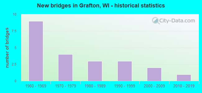
- New bridges - historical statistics
- 91960-1969
- 41970-1979
- 31980-1989
- 31990-1999
- 22000-2009
- 12010-2019


- Bridge Condition - Deck
- 23.1%Good
- 61.5%Satisfactory
- 15.4%Fair

- Bridge Condition - Superstructure
- 21.4%Very good
- 35.7%Good
- 28.6%Satisfactory
- 14.3%Fair

- Bridge Condition - Substructure
- 35.7%Good
- 57.1%Satisfactory
- 7.1%Fair

- Bridge Condition - Channel
- 33.3%Very good
- 44.4%Good
- 11.1%Satisfactory
- 11.1%Poor
Find on map >> Show street view
Structure Number: B450015, Location: 0.3 MI E JCT CTH W (Lat: 43.320275, Lng: -87.920011), Route carried "on" structure: State highway 60, Year Built: 2001, Status: Open, Structure Length: 6.82m (22.38ft), Average Daily Traffic: 17,500 (year 2019), Truck Traffic: 5%, Average Future Daily Traffic: 26,500 (year 2040), Design Load: HS 20, Features Intersected: IH 43/STH 32/STH 57
Minimum Vertical Clearance: 30+ m (98+ ft), Kilometerpoint: 0.000, Lanes on structure: 4, Lanes under structure: 4, Base Highway Network: Yes, Owner: State Highway Agency, Approaching Roadway Width: 25.0m (82.0ft), Skew: 20 degrees, Material/Design: Prestressed concrete continuous, Design/Construction: Stringer/Multi-beam, Number Of Spans In Main Unit: 2, Length of Maximum Span: 34.5m (113.2ft), Curb or Sidewalk Widths: Left: 0.0m, Right: 2.3m (7.5ft), Curb-To-Curb Width: 28.5m (93.5ft), Out-to-Out Width: 31.5m (103.3ft)
Condition: Deck: Good, Superstructure: Good, Substructure: Good, Operating Rating: 52.3 metric tons, Method Used To Determine Operating Rating: Load Factor (LF), Inventory Rating: 32.4 metric tons, Method Used To Determine Inventory Rating: Load Factor (LF), Structural Evaluation: Better than present minimum criteria, Deck Geometry: Superior to present desirable criteria, Underclear: Somewhat better than minimum adequacy, Approach Roadway Alignment: Equal to present desirable criteria, Designated Inspection Frequency: Every 48 months, Inspection Date: May 2021, Deck Structure Type: Concrete Cast-file-Place, Wearing Surface/Protective System: Wearing Surface: Low Slump Concrete, Deck Protection: Epoxy Coated Reinforcing
Find on map >> Show street view
Structure Number: B450023, Location: 2.0M S JCT STH 60 TO W (Lat: 43.294942, Lng: -87.920808), Route carried "on" structure: Interstate 43, Year Built: 1967, Status: Open, Structure Length: 2.89m (9.48ft), Average Daily Traffic: 26,600 (year 2019), Truck Traffic: 13%, Average Future Daily Traffic: 32,154 (year 2040), Design Load: HS 20, Features Intersected: LRD LAKEFIELD RD
Minimum Vertical Clearance: 30+ m (98+ ft), Kilometerpoint: 0.000, Lanes on structure: 2, Lanes under structure: 2, Base Highway Network: Yes, Owner: State Highway Agency, Approaching Roadway Width: 12.2m (40.0ft), Material/Design: Concrete continuous, Design/Construction: Slab, Number Of Spans In Main Unit: 3, Length of Maximum Span: 11.7m (38.4ft), Curb-To-Curb Width: 11.9m (39.0ft), Out-to-Out Width: 12.8m (42.0ft)
Condition: Deck: Satisfactory, Superstructure: Satisfactory, Substructure: Satisfactory, Operating Rating: 45.7 metric tons, Method Used To Determine Operating Rating: Load Factor (LF), Inventory Rating: 27.5 metric tons, Method Used To Determine Inventory Rating: Load Factor (LF), Structural Evaluation: Equal to present minimum criteria, Deck Geometry: Equal to present minimum criteria, Underclear: Meets minimum limits, Approach Roadway Alignment: Equal to present desirable criteria, Designated Inspection Frequency: Every 24 months, Inspection Date: May 2021, Deck Structure Type: Concrete Cast-file-Place, Wearing Surface/Protective System: Wearing Surface: Bituminous
Find on map >> Show street view
Structure Number: B450024, Location: 5.3 MI N JCT STH 167 (Lat: 43.294683, Lng: -87.920297), Route carried "on" structure: Interstate 43, Year Built: 1967, Status: Open, Structure Length: 2.89m (9.48ft), Average Daily Traffic: 26,600 (year 2019), Truck Traffic: 13%, Average Future Daily Traffic: 36,045 (year 2040), Design Load: HS 20, Features Intersected: LRD LAKEFIELD RD
Minimum Vertical Clearance: 30+ m (98+ ft), Kilometerpoint: 0.000, Lanes on structure: 2, Lanes under structure: 2, Base Highway Network: Yes, Owner: State Highway Agency, Approaching Roadway Width: 12.2m (40.0ft), Material/Design: Concrete continuous, Design/Construction: Slab, Number Of Spans In Main Unit: 3, Length of Maximum Span: 11.7m (38.4ft), Curb-To-Curb Width: 11.9m (39.0ft), Out-to-Out Width: 12.8m (42.0ft)
Condition: Deck: Satisfactory, Superstructure: Satisfactory, Substructure: Satisfactory, Operating Rating: 45.7 metric tons, Method Used To Determine Operating Rating: Load Factor (LF), Inventory Rating: 27.5 metric tons, Method Used To Determine Inventory Rating: Load Factor (LF), Structural Evaluation: Equal to present minimum criteria, Deck Geometry: Equal to present minimum criteria, Underclear: Meets minimum limits, Approach Roadway Alignment: Equal to present desirable criteria, Designated Inspection Frequency: Every 24 months, Inspection Date: May 2021, Deck Structure Type: Concrete Cast-file-Place, Wearing Surface/Protective System: Wearing Surface: Bituminous
Find on map >> Show street view
Structure Number: B450025, Location: 0.2 MI E JCT CTH W (Lat: 43.309375, Lng: -87.920967), Route carried "on" structure: City street , Year Built: 1967, Status: Open, Structure Length: 5.72m (18.77ft), Average Daily Traffic: 770 (year 2019), Average Future Daily Traffic: 770 (year 2040), Design Load: H 15, Features Intersected: IH 43-STH 32-STH 57, Facility Carried by Structure: LRD FALLS RD
Minimum Vertical Clearance: 30+ m (98+ ft), Kilometerpoint: 0.000, Lanes on structure: 2, Lanes under structure: 4, Owner: State Highway Agency, Approaching Roadway Width: 7.0m (23.0ft), Material/Design: Steel continuous, Design/Construction: Stringer/Multi-beam, Number Of Spans In Main Unit: 2, Length of Maximum Span: 28.0m (91.9ft), Curb-To-Curb Width: 8.2m (26.9ft), Out-to-Out Width: 9.3m (30.5ft)
Condition: Deck: Fair, Superstructure: Fair, Substructure: Satisfactory, Operating Rating: 29.4 metric tons, Method Used To Determine Operating Rating: Load Factor (LF), Inventory Rating: 17.8 metric tons, Method Used To Determine Inventory Rating: Load Factor (LF), Structural Evaluation: Meets minimum limits, Deck Geometry: Somewhat better than minimum adequacy, Underclear: Meets minimum limits, Approach Roadway Alignment: Equal to present desirable criteria, Designated Inspection Frequency: Every 24 months, Inspection Date: May 2021, Deck Structure Type: Concrete Cast-file-Place, Wearing Surface/Protective System: Wearing Surface: Low Slump Concrete
Find on map >> Show street view
Structure Number: B450027, Location: 0.1M E JCT CTH W (Lat: 43.331203, Lng: -87.922556), Route carried "on" structure: City street , Year Built: 1967, Status: Open, Structure Length: 6.27m (20.57ft), Average Daily Traffic: 1,146 (year 2019), Average Future Daily Traffic: 1,146 (year 2040), Design Load: H 15, Features Intersected: IH 43/STH 32/STH 57, Facility Carried by Structure: LRD ARROWHEAD RD (
Minimum Vertical Clearance: 30+ m (98+ ft), Kilometerpoint: 0.000, Lanes on structure: 2, Lanes under structure: 4, Owner: State Highway Agency, Approaching Roadway Width: 8.5m (27.9ft), Skew: 1 degrees, Material/Design: Steel continuous, Design/Construction: Stringer/Multi-beam, Number Of Spans In Main Unit: 2, Length of Maximum Span: 30.5m (100.1ft), Curb-To-Curb Width: 8.2m (26.9ft), Out-to-Out Width: 9.0m (29.5ft)
Condition: Deck: Satisfactory, Superstructure: Satisfactory, Substructure: Satisfactory, Operating Rating: 45.7 metric tons, Method Used To Determine Operating Rating: Load Factor (LF), Inventory Rating: 22.7 metric tons, Method Used To Determine Inventory Rating: Load Factor (LF), Structural Evaluation: Equal to present minimum criteria, Deck Geometry: Meets minimum limits, Underclear: High priority of replacement, Approach Roadway Alignment: Equal to present desirable criteria, Length Of Structure Improvement: 6.71m (22.01ft), Designated Inspection Frequency: Every 24 months, Inspection Date: July 2021, Bridge Improvement Cost: $714,000, Roadway Improvement Cost: $71,000, Total Project Cost: $1,072,000 ( Estimate for 2021), Deck Structure Type: Concrete Cast-file-Place, Wearing Surface/Protective System: Wearing Surface: Low Slump Concrete
Find on map >> Show street view
Structure Number: B450028, Location: 5.2M N JCT STH 167 TO W (Lat: 43.292992, Lng: -87.920619), Route carried "on" structure: Interstate 43, Year Built: 1966, Status: Open, Structure Length: 0.96m (3.15ft), Average Daily Traffic: 53,200 (year 2019), Truck Traffic: 13%, Average Future Daily Traffic: 68,200 (year 2039), Design Load: HS 20, Features Intersected: BR MILWAUKEE RIVER
Minimum Vertical Clearance: 30+ m (98+ ft), Kilometerpoint: 0.000, Lanes on structure: 4, Base Highway Network: Yes, Owner: State Highway Agency, Approaching Roadway Width: 23.2m (76.1ft), Skew: 12 degrees, Material/Design: Concrete continuous, Design/Construction: Culvert, Number Of Spans In Main Unit: 3, Length of Maximum Span: 2.7m (8.9ft)
Condition: Channel: Poor, Culverts: Satisfactory, Operating Rating: 53.9 metric tons, Method Used To Determine Operating Rating: Field evaluation and documented engineering judgment, Inventory Rating: 32.4 metric tons, Method Used To Determine Inventory Rating: Field evaluation and documented engineering judgment, Structural Evaluation: Equal to present minimum criteria, Waterway Adequacy: Superior to present desirable criteria, Approach Roadway Alignment: Equal to present desirable criteria, Designated Inspection Frequency: Every 24 months, Inspection Date: August 2020, Deck Structure Type: Concrete Cast-file-Place, Wearing Surface/Protective System: Wearing Surface: Monolithic Concrete
Find on map >> Show street view
Structure Number: B450031, Location: 3.7 MI S JCT STH 33 (Lat: 43.341211, Lng: -87.924289), Route carried "on" structure: State highway 32, Year Built: 1975, Status: Open, Structure Length: 11.97m (39.27ft), Average Daily Traffic: 8,800 (year 2019), Truck Traffic: 5%, Average Future Daily Traffic: 6,266 (year 2040), Design Load: HS 20, Features Intersected: IH 43-STH 57
Minimum Vertical Clearance: 30+ m (98+ ft), Kilometerpoint: 0.000, Lanes on structure: 2, Lanes under structure: 4, Base Highway Network: Yes, Owner: State Highway Agency, Approaching Roadway Width: 13.4m (44.0ft), Skew: 5 degrees, Material/Design: Steel continuous, Design/Construction: Stringer/Multi-beam, Number Of Spans In Main Unit: 2, Length of Maximum Span: 58.7m (192.6ft), Curb-To-Curb Width: 12.2m (40.0ft), Out-to-Out Width: 13.4m (44.0ft)
Condition: Deck: Satisfactory, Superstructure: Satisfactory, Substructure: Satisfactory, Operating Rating: 35.9 metric tons, Method Used To Determine Operating Rating: Load Factor (LF), Inventory Rating: 21.1 metric tons, Method Used To Determine Inventory Rating: Load Factor (LF), Structural Evaluation: Somewhat better than minimum adequacy, Deck Geometry: Better than present minimum criteria, Underclear: Equal to present minimum criteria, Approach Roadway Alignment: Equal to present desirable criteria, Designated Inspection Frequency: Every 24 months, Inspection Date: July 2021, Deck Structure Type: Concrete Cast-file-Place, Wearing Surface/Protective System: Wearing Surface: Low Slump Concrete
Find on map >> Show street view
Structure Number: B450071, Location: 0.1 M E OF JCT GREEN BAY (Lat: 43.309422, Lng: -87.951803), Route carried "on" structure: City street , Year Built: 1985, Status: Open, Structure Length: 6.04m (19.82ft), Average Daily Traffic: 5,300 (year 2019), Average Future Daily Traffic: 6,864 (year 2039), Design Load: HS 20, Features Intersected: MILWAUKEE RIVER, Facility Carried by Structure: LRD FALLS RD
Minimum Vertical Clearance: 30+ m (98+ ft), Kilometerpoint: 0.000, Lanes on structure: 2, Owner: City or Municipal Highway Agency, Approaching Roadway Width: 9.1m (29.9ft), Skew: 2 degrees, Material/Design: Steel, Design/Construction: Stringer/Multi-beam, Number Of Spans In Main Unit: 1, Length of Maximum Span: 58.5m (191.9ft), Curb or Sidewalk Widths: Left: 2.0m (6.6ft), Right: 0.0m, Curb-To-Curb Width: 9.1m (29.9ft), Out-to-Out Width: 11.4m (37.4ft)
Condition: Deck: Satisfactory, Superstructure: Good, Substructure: Satisfactory, Channel: Very good, Operating Rating: 90.0 metric tons, Method Used To Determine Operating Rating: Load Factor (LF), Inventory Rating: 53.5 metric tons, Method Used To Determine Inventory Rating: Load Factor (LF), Structural Evaluation: Equal to present minimum criteria, Deck Geometry: Meets minimum limits, Waterway Adequacy: Equal to present desirable criteria, Approach Roadway Alignment: Equal to present minimum criteria, Designated Inspection Frequency: Every 24 months, Inspection Date: September 2020, Deck Structure Type: Concrete Cast-file-Place, Wearing Surface/Protective System: Wearing Surface: Monolithic Concrete, Deck Protection: Epoxy Coated Reinforcing
Find on map >> Show street view
Structure Number: B450072, Location: 0.8M E JCT CTH W (Lat: 43.294769, Lng: -87.919269), Route carried "on" structure: City street , Year Built: 1984, Status: Open, Structure Length: 1.27m (4.17ft), Average Daily Traffic: 670 (year 2019), Average Future Daily Traffic: 721 (year 2039), Design Load: HS 20, Features Intersected: ULAO CREEK, Facility Carried by Structure: LRD LAKEFIELD RD
Minimum Vertical Clearance: 30+ m (98+ ft), Kilometerpoint: 0.000, Lanes on structure: 2, Owner: Town or Township Highway Agency, Approaching Roadway Width: 8.5m (27.9ft), Material/Design: Prestressed concrete, Design/Construction: Stringer/Multi-beam, Number Of Spans In Main Unit: 1, Length of Maximum Span: 12.2m (40.0ft), Curb-To-Curb Width: 8.5m (27.9ft), Out-to-Out Width: 9.1m (29.9ft)
Condition: Deck: Good, Superstructure: Very good, Substructure: Good, Channel: Good, Operating Rating: 52.3 metric tons, Method Used To Determine Operating Rating: Load Factor (LF), Inventory Rating: 45.4 metric tons, Method Used To Determine Inventory Rating: Load Factor (LF), Structural Evaluation: Better than present minimum criteria, Deck Geometry: Somewhat better than minimum adequacy, Waterway Adequacy: Equal to present desirable criteria, Approach Roadway Alignment: Equal to present desirable criteria, Designated Inspection Frequency: Every 48 months, Inspection Date: September 2020, Deck Structure Type: Concrete Cast-file-Place, Wearing Surface/Protective System: Wearing Surface: Bituminous, Deck Protection: Epoxy Coated Reinforcing
Find on map >> Show street view
Structure Number: B45008, Location: 0.7M N JCT STH 167 (Lat: 43.232389, Lng: -87.983725), Route carried "on" structure: City street , Year Built: 1988, Status: Open, Structure Length: 1.91m (6.27ft), Average Daily Traffic: 7,700 (year 2019), Truck Traffic: 9%, Average Future Daily Traffic: 9,471 (year 2039), Design Load: HS 20, Features Intersected: PIGEON CREEK, Facility Carried by Structure: LRD MAIN STREET
Minimum Vertical Clearance: 30+ m (98+ ft), Kilometerpoint: 0.000, Lanes on structure: 3, Base Highway Network: Yes, Owner: City or Municipal Highway Agency, Approaching Roadway Width: 14.6m (47.9ft), Material/Design: Prestressed concrete, Design/Construction: Slab, Number Of Spans In Main Unit: 1, Length of Maximum Span: 18.6m (61.0ft), Curb or Sidewalk Widths: Left: 2.0m (6.6ft), Right: 5.1m (16.7ft), Curb-To-Curb Width: 11.3m (37.1ft), Out-to-Out Width: 18.9m (62.0ft)
Condition: Deck: Satisfactory, Superstructure: Good, Substructure: Good, Channel: Good, Operating Rating: 60.4 metric tons, Method Used To Determine Operating Rating: Load Factor (LF), Inventory Rating: 35.6 metric tons, Method Used To Determine Inventory Rating: Load Factor (LF), Structural Evaluation: Better than present minimum criteria, Deck Geometry: High priority of replacement, Waterway Adequacy: Equal to present desirable criteria, Approach Roadway Alignment: Equal to present desirable criteria, Length Of Structure Improvement: 2.35m (7.71ft), Designated Inspection Frequency: Every 24 months, Inspection Date: September 2020, Bridge Improvement Cost: $378,000, Roadway Improvement Cost: $37,000, Total Project Cost: $567,000 ( Estimate for 2021), Deck Structure Type: Concrete Cast-file-Place, Wearing Surface/Protective System: Wearing Surface: Low Slump Concrete, Deck Protection: Epoxy Coated Reinforcing
Find on map >> Show street view
Structure Number: B450083, Location: 0.1M W JCT CTH V (Lat: 43.319925, Lng: -87.950053), Route carried "on" structure: State highway 60, Year Built: 1990, Status: Open, Structure Length: 9.00m (29.53ft), Average Daily Traffic: 22,700 (year 2019), Truck Traffic: 3%, Average Future Daily Traffic: 24,252 (year 2039), Design Load: HS 20, Features Intersected: MILWAUKEE RIVER
Minimum Vertical Clearance: 30+ m (98+ ft), Kilometerpoint: 0.000, Lanes on structure: 2, Base Highway Network: Yes, Owner: City or Municipal Highway Agency, Approaching Roadway Width: 13.4m (44.0ft), Material/Design: Prestressed concrete continuous, Design/Construction: Stringer/Multi-beam, Number Of Spans In Main Unit: 5, Length of Maximum Span: 17.8m (58.4ft), Curb or Sidewalk Widths: Left: 2.0m (6.6ft), Right: 2.0m (6.6ft), Curb-To-Curb Width: 14.6m (47.9ft), Out-to-Out Width: 18.6m (61.0ft)
Condition: Deck: Satisfactory, Superstructure: Very good, Substructure: Satisfactory, Channel: Good, Operating Rating: 62.1 metric tons, Method Used To Determine Operating Rating: Load Factor (LF), Inventory Rating: 34.0 metric tons, Method Used To Determine Inventory Rating: Load Factor (LF), Structural Evaluation: Equal to present minimum criteria, Deck Geometry: Superior to present desirable criteria, Waterway Adequacy: Equal to present desirable criteria, Approach Roadway Alignment: Equal to present desirable criteria, Designated Inspection Frequency: Every 24 months, Inspection Date: September 2020, Deck Structure Type: Concrete Cast-file-Place, Wearing Surface/Protective System: Wearing Surface: Monolithic Concrete, Deck Protection: Epoxy Coated Reinforcing
Find on map >> Show street view
Structure Number: B450084, Location: 0.3M E JCT CTH I (Lat: 43.322950, Lng: -87.979036), Route carried "on" structure: State highway 60, Year Built: 1994, Status: Open, Structure Length: 3.74m (12.27ft), Average Daily Traffic: 14,900 (year 2018), Truck Traffic: 3%, Average Future Daily Traffic: 15,110 (year 2037), Design Load: HS 20, Features Intersected: CEDAR CREEK
Minimum Vertical Clearance: 30+ m (98+ ft), Kilometerpoint: 0.000, Lanes on structure: 2, Base Highway Network: Yes, Owner: State Highway Agency, Approaching Roadway Width: 13.4m (44.0ft), Skew: 1 degrees, Material/Design: Prestressed concrete continuous, Design/Construction: Stringer/Multi-beam, Number Of Spans In Main Unit: 2, Length of Maximum Span: 18.3m (60.0ft), Curb or Sidewalk Widths: Left: 2.0m (6.6ft), Right: 2.0m (6.6ft), Curb-To-Curb Width: 15.8m (51.8ft), Out-to-Out Width: 19.5m (64.0ft)
Condition: Deck: Good, Superstructure: Good, Substructure: Good, Channel: Very good, Operating Rating: 68.6 metric tons, Method Used To Determine Operating Rating: Load Factor (LF), Inventory Rating: 35.6 metric tons, Method Used To Determine Inventory Rating: Load Factor (LF), Structural Evaluation: Better than present minimum criteria, Deck Geometry: Superior to present desirable criteria, Waterway Adequacy: Equal to present desirable criteria, Approach Roadway Alignment: Equal to present desirable criteria, Designated Inspection Frequency: Every 48 months, Inspection Date: August 2018, Deck Structure Type: Concrete Cast-file-Place, Wearing Surface/Protective System: Wearing Surface: Monolithic Concrete, Deck Protection: Epoxy Coated Reinforcing
Find on map >> Show street view
Structure Number: B450089, Location: 0.1M E JCT STH 57 (Lat: 43.318569, Lng: -87.949253), Route carried "on" structure: City street , Year Built: 1996, Status: Open, Structure Length: 4.04m (13.25ft), Average Daily Traffic: 1,300 (year 2019), Average Future Daily Traffic: 1,014 (year 2039), Design Load: HS 20, Features Intersected: MILWAUKEE RIVER, Facility Carried by Structure: LRD BRIDGE ST
Minimum Vertical Clearance: 30+ m (98+ ft), Kilometerpoint: 0.000, Lanes on structure: 2, Owner: City or Municipal Highway Agency, Approaching Roadway Width: 9.8m (32.2ft), Material/Design: Prestressed concrete, Design/Construction: Stringer/Multi-beam, Number Of Spans In Main Unit: 1, Length of Maximum Span: 39.6m (129.9ft), Curb or Sidewalk Widths: Left: 2.6m (8.5ft), Right: 0.0m, Curb-To-Curb Width: 9.8m (32.2ft), Out-to-Out Width: 13.0m (42.7ft)
Condition: Deck: Satisfactory, Superstructure: Very good, Substructure: Satisfactory, Channel: Very good, Operating Rating: 98.0 metric tons, Method Used To Determine Operating Rating: Load Factor (LF), Inventory Rating: 40.5 metric tons, Method Used To Determine Inventory Rating: Load Factor (LF), Structural Evaluation: Equal to present minimum criteria, Deck Geometry: Somewhat better than minimum adequacy, Waterway Adequacy: Equal to present desirable criteria, Approach Roadway Alignment: Equal to present desirable criteria, Designated Inspection Frequency: Every 24 months, Inspection Date: September 2020, Deck Structure Type: Concrete Cast-file-Place, Wearing Surface/Protective System: Wearing Surface: Monolithic Concrete, Deck Protection: Epoxy Coated Reinforcing
Find on map >> Show street view
Structure Number: B450101, Location: 1.2 MILES NORTH OF STH 60 (Lat: 43.336667, Lng: -87.949533), Route carried "on" structure: County highway , Year Built: 2015, Status: Open, Structure Length: 0.76m (2.49ft), Average Daily Traffic: 3,800 (year 2019), Average Future Daily Traffic: 3,800 (year 2039), Design Load: HL 93, Features Intersected: MOLE CREEK, Facility Carried by Structure: CTH O/N GREEN BAY
Minimum Vertical Clearance: 30+ m (98+ ft), Kilometerpoint: 0.000, Lanes on structure: 2, Base Highway Network: Yes, Owner: County Highway Agency, Approaching Roadway Width: 10.4m (34.1ft), Skew: 1 degrees, Material/Design: Steel, Design/Construction: Arch - Deck, Number Of Spans In Main Unit: 1, Length of Maximum Span: 7.6m (24.9ft), Curb-To-Curb Width: 11.6m (38.1ft), Out-to-Out Width: 21.9m (71.9ft)
Condition: Superstructure: Good, Substructure: Good, Channel: Good, Operating Rating: 42.1 metric tons, Method Used To Determine Operating Rating: Load and Resistance Factor Rating (LRFR) rating reported by rating factor(RF) method using HL-93 loadings, Inventory Rating: 32.4 metric tons, Method Used To Determine Inventory Rating: Load and Resistance Factor Rating (LRFR) rating reported by rating factor(RF) method using HL-93 loadings, Structural Evaluation: Better than present minimum criteria, Deck Geometry: Somewhat better than minimum adequacy, Waterway Adequacy: Equal to present desirable criteria, Approach Roadway Alignment: Equal to present desirable criteria, Designated Inspection Frequency: Every 24 months, Inspection Date: September 2020, Deck Structure Type: Steel plate, Wearing Surface/Protective System: Wearing Surface: Bituminous
Find on map >> Show street view
Structure Number: P450038, Location: 0.3M E JCT CTH I (Lat: 43.337481, Lng: -87.977422), Route carried "on" structure: City street , Year Built: 1970, Status: Open, Structure Length: 2.58m (8.46ft), Average Daily Traffic: 1,127 (year 2019), Average Future Daily Traffic: 1,239 (year 2039), Design Load: H 20, Features Intersected: CEDAR CREEK, Facility Carried by Structure: LRD CEDAR CREEK RD
Minimum Vertical Clearance: 30+ m (98+ ft), Kilometerpoint: 0.000, Lanes on structure: 2, Owner: Town or Township Highway Agency, Approaching Roadway Width: 9.8m (32.2ft), Material/Design: Prestressed concrete, Design/Construction: Slab, Number Of Spans In Main Unit: 1, Length of Maximum Span: 25.0m (82.0ft), Curb-To-Curb Width: 10.1m (33.1ft), Out-to-Out Width: 11.1m (36.4ft)
Condition: Deck: Fair, Superstructure: Fair, Substructure: Fair, Channel: Satisfactory, Operating Rating: 49.0 metric tons, Method Used To Determine Operating Rating: Load Factor (LF), Inventory Rating: 32.4 metric tons, Method Used To Determine Inventory Rating: Load Factor (LF), Structural Evaluation: Somewhat better than minimum adequacy, Deck Geometry: Somewhat better than minimum adequacy, Waterway Adequacy: Equal to present desirable criteria, Approach Roadway Alignment: Equal to present desirable criteria, Designated Inspection Frequency: Every 24 months, Inspection Date: September 2020, Deck Structure Type: Concrete Cast-file-Place, Wearing Surface/Protective System: Wearing Surface: Monolithic Concrete
Find on map >> Show street view
Structure Number: B450015, Location: 7.0M N JCT STH167 TO W (Lat: 43.320275, Lng: -87.920011), Route carried "under" structure: Interstate 43, Year Built: 2001, Structure Length: 0. m, Average Daily Traffic: 50,300 (year 2019), Features Intersected: IH 43/STH 32/STH 57, Facility Carried by Structure: STH 60
Minimum Vertical Clearance: 4.89m (16.04ft), Kilometerpoint: 0.000, Lanes on structure: 4, Lanes under structure: 4, Material/Design: Prestressed concrete continuous, Design/Construction: Stringer/Multi-beam, Length of Maximum Span: 34.5m (113.2ft)
Find on map >> Show street view
Structure Number: B450023, Location: 0.2M E JCT CTH W (Lat: 43.294942, Lng: -87.920808), Route carried "under" structure: City street , Year Built: 1967, Structure Length: 0. m, Average Daily Traffic: 670 (year 2019), Features Intersected: LRD LAKEFIELD RD, Facility Carried by Structure: IH 43 SB-STH 32 SB
Minimum Vertical Clearance: 4.54m (14.90ft), Kilometerpoint: 0.000, Lanes on structure: 2, Lanes under structure: 2, Material/Design: Concrete continuous, Design/Construction: Slab, Length of Maximum Span: 11.7m (38.4ft)
Find on map >> Show street view
Structure Number: B450024, Location: 0.2M E JCT CTH W (Lat: 43.294683, Lng: -87.920297), Route carried "under" structure: City street , Year Built: 1967, Structure Length: 0. m, Average Daily Traffic: 670 (year 2019), Features Intersected: LRD LAKEFIELD RD, Facility Carried by Structure: IH 43/STH 32/STH 5
Minimum Vertical Clearance: 4.56m (14.96ft), Kilometerpoint: 0.000, Lanes on structure: 2, Lanes under structure: 2, Material/Design: Concrete continuous, Design/Construction: Slab, Length of Maximum Span: 11.7m (38.4ft)
Find on map >> Show street view
Structure Number: B450025, Location: 6.3M N JCT STH 167 TO W (Lat: 43.309375, Lng: -87.920967), Route carried "under" structure: Interstate 43, Year Built: 1967, Structure Length: 0. m, Average Daily Traffic: 58,400 (year 2019), Truck Traffic: 13%, Features Intersected: IH 43-STH 32-STH 57, Facility Carried by Structure: LRD FALLS RD
Minimum Vertical Clearance: 4.61m (15.12ft), Kilometerpoint: 0.000, Lanes on structure: 2, Lanes under structure: 4, Material/Design: Steel continuous, Design/Construction: Stringer/Multi-beam, Length of Maximum Span: 28.0m (91.9ft)
Find on map >> Show street view
Structure Number: B450027, Location: 0.9M N JCT STH 60 TO W (Lat: 43.331203, Lng: -87.922556), Route carried "under" structure: Interstate 43, Year Built: 1967, Structure Length: 0. m, Average Daily Traffic: 45,200 (year 2019), Truck Traffic: 14%, Features Intersected: IH 43/STH 32/STH 57, Facility Carried by Structure: LRD ARROWHEAD RD (
Minimum Vertical Clearance: 4.54m (14.90ft), Kilometerpoint: 0.000, Lanes on structure: 2, Lanes under structure: 4, Material/Design: Steel continuous, Design/Construction: Stringer/Multi-beam, Length of Maximum Span: 30.5m (100.1ft)
Find on map >> Show street view
Structure Number: B45003, Location: 1.6M N JCT STH 60 TO W (Lat: 43.339753, Lng: -87.925142), Route carried "under" structure: Interstate 43, Year Built: 1975, Structure Length: 0. m, Average Daily Traffic: 45,200 (year 2019), Truck Traffic: 14%, Features Intersected: IH 43/STH 57, Facility Carried by Structure: CTH V NB
Minimum Vertical Clearance: 5.39m (17.68ft), Kilometerpoint: 0.000, Lanes on structure: 2, Lanes under structure: 4, Material/Design: Steel continuous, Design/Construction: Stringer/Multi-beam, Length of Maximum Span: 59.4m (194.9ft)
Find on map >> Show street view
Structure Number: B450031, Location: 1.6M N JCT STH 60 TO W (Lat: 43.341211, Lng: -87.924289), Route carried "under" structure: Interstate 43, Year Built: 1975, Structure Length: 0. m, Average Daily Traffic: 45,200 (year 2019), Truck Traffic: 14%, Features Intersected: IH 43-STH 57, Facility Carried by Structure: STH 32 SB
Minimum Vertical Clearance: 5.11m (16.77ft), Kilometerpoint: 0.000, Lanes on structure: 2, Lanes under structure: 4, Material/Design: Steel continuous, Design/Construction: Stringer/Multi-beam, Length of Maximum Span: 58.7m (192.6ft)