Bridge Statistics for Gonzalez, Florida (FL)
Condition, Traffic, Stress, Structural Evaluation, Project Costs
- National Bridge Inventory (NBI) Statistics
- 18Number of bridges
- 482ft / 147mTotal length
- 143,903Total average daily traffic
- 21,981Total average daily truck traffic
- National Bridge Inventory (NBI) Registered Bridges for Gonzalez
- No street view available for this location
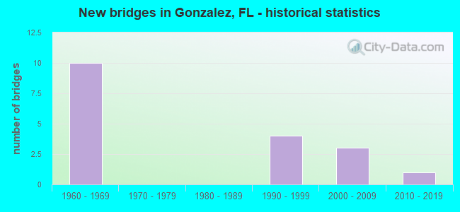
- New bridges - historical statistics
- 101960-1969
- 41990-1999
- 32000-2009
- 12010-2019


- Bridge Condition - Deck
- 50.0%Good
- 41.7%Satisfactory
- 8.3%Fair

- Bridge Condition - Superstructure
- 66.7%Good
- 16.7%Satisfactory
- 8.3%Fair
- 8.3%Poor

- Bridge Condition - Substructure
- 75.0%Good
- 16.7%Satisfactory
- 8.3%Fair

- Bridge Condition - Channel
- 7.1%Very good
- 57.1%Good
- 28.6%Satisfactory
- 7.1%Fair

- Bridge Condition - Culverts
- 25.0%Very good
- 25.0%Good
- 50.0%Satisfactory
Find on map >> Show street view
Structure Number: 480028, Location: 0.5 Mi E of CR 297A (Lat: 30.573803, Lng: -87.321669), Route carried "on" structure: County highway 186, Year Built: 1968, Status: Posted for load, Structure Length: 5.48m (17.98ft), Average Daily Traffic: 3,000 (year 2022), Truck Traffic: 8%, Average Future Daily Traffic: 5,205 (year 2042), Features Intersected: Eleven Mile Creek
Minimum Vertical Clearance: 30+ m (98+ ft), Kilometerpoint: 2.805, Lanes on structure: 2, Owner: County Highway Agency, Approaching Roadway Width: 7.3m (24.0ft), Material/Design: Wood or Timber, Design/Construction: Stringer/Multi-beam, Number Of Spans In Main Unit: 12, Length of Maximum Span: 4.6m (15.1ft), Curb or Sidewalk Widths: Left: 0.2m (0.7ft), Right: 0.2m (0.7ft), Curb-To-Curb Width: 7.2m (23.6ft), Out-to-Out Width: 7.7m (25.3ft)
Condition: Deck: Fair, Superstructure: Satisfactory, Substructure: Fair, Channel: Fair, Operating Rating: 28.8 metric tons, Method Used To Determine Operating Rating: Allowable Stress (AS), Inventory Rating: 20.0 metric tons, Method Used To Determine Inventory Rating: Allowable Stress (AS), Structural Evaluation: Somewhat better than minimum adequacy, Deck Geometry: High priority of replacement, Waterway Adequacy: Better than present minimum criteria, Approach Roadway Alignment: Equal to present desirable criteria, Bridge Posting: Required (Relationship of Operating Rating to Maximum Legal Load: 20.0 - 29.9% below), Designated Inspection Frequency: Every 24 months, Underwater Inspection Frequency: Every 24 months, Other Special Inspection Frequency: Every 12 months, Inspection Date: Febuary 2021, Underwater Inspection Date: Febuary 2021, Other Special Inspection Date: Febuary 2022, Deck Structure Type: Concrete Cast-file-Place
Find on map >> Show street view
Structure Number: 480061, Location: 1.6 Miles West of SR297 (Lat: 30.534594, Lng: -87.334350), Route carried "on" structure: Interstate 10, Year Built: 1961, Year Reconstructed: 1993, Status: Open, Structure Length: 8.60m (28.22ft), Average Daily Traffic: 21,514 (year 2020), Truck Traffic: 19%, Average Future Daily Traffic: 37,327 (year 2042), Design Load: HS 20, Features Intersected: US90A SR10
Minimum Vertical Clearance: 30+ m (98+ ft), Kilometerpoint: 8.853, Lanes on structure: 2, Lanes under structure: 4, Base Highway Network: Yes, Owner: State Highway Agency, Approaching Roadway Width: 11.6m (38.1ft), Skew: 5 degrees, Material/Design: Prestressed concrete, Design/Construction: Stringer/Multi-beam, Number Of Spans In Main Unit: 4, Length of Maximum Span: 23.3m (76.4ft), Curb-To-Curb Width: 12.2m (40.0ft), Out-to-Out Width: 13.1m (43.0ft)
Condition: Deck: Satisfactory, Superstructure: Poor, Substructure: Good, Operating Rating: 42.1 metric tons, Method Used To Determine Operating Rating: Load Factor (LF), Inventory Rating: 37.2 metric tons, Method Used To Determine Inventory Rating: Load Factor (LF), Structural Evaluation: Meets minimum limits, Deck Geometry: Better than present minimum criteria, Underclear: Meets minimum limits, Approach Roadway Alignment: Equal to present desirable criteria, Designated Inspection Frequency: Every 24 months, Inspection Date: Febuary 2022, Deck Structure Type: Concrete Cast-file-Place
Find on map >> Show street view
Structure Number: 480066, Location: 1.6 Miles West of SR297 (Lat: 30.534647, Lng: -87.334853), Route carried "on" structure: Interstate 10, Year Built: 1961, Year Reconstructed: 1993, Status: Open, Structure Length: 8.60m (28.22ft), Average Daily Traffic: 21,514 (year 2020), Truck Traffic: 19%, Average Future Daily Traffic: 37,327 (year 2042), Design Load: HS 20, Features Intersected: US90A SR10
Minimum Vertical Clearance: 30+ m (98+ ft), Kilometerpoint: 8.853, Lanes on structure: 2, Lanes under structure: 4, Base Highway Network: Yes, Owner: State Highway Agency, Approaching Roadway Width: 11.6m (38.1ft), Skew: 5 degrees, Material/Design: Prestressed concrete, Design/Construction: Stringer/Multi-beam, Number Of Spans In Main Unit: 4, Length of Maximum Span: 23.3m (76.4ft), Curb-To-Curb Width: 12.2m (40.0ft), Out-to-Out Width: 13.1m (43.0ft)
Condition: Deck: Satisfactory, Superstructure: Good, Substructure: Good, Operating Rating: 39.6 metric tons, Method Used To Determine Operating Rating: Load and Resistance Factor (LRFR), Inventory Rating: 15.9 metric tons, Method Used To Determine Inventory Rating: Load and Resistance Factor (LRFR), Structural Evaluation: High priority of corrective action, Deck Geometry: Better than present minimum criteria, Underclear: Meets minimum limits, Approach Roadway Alignment: Equal to present desirable criteria, Designated Inspection Frequency: Every 24 months, Inspection Date: Febuary 2022, Deck Structure Type: Concrete Cast-file-Place
Find on map >> Show street view
Structure Number: 480069, Location: 0.5mi West of US90 SR10 (Lat: 30.538342, Lng: -87.339836), Route carried "on" structure: Interstate 10, Year Built: 1966, Year Reconstructed: 1991, Status: Open, Structure Length: 12.80m (41.99ft), Average Daily Traffic: 15,000 (year 2020), Truck Traffic: 24%, Average Future Daily Traffic: 26,025 (year 2042), Design Load: HS 20, Features Intersected: Eleven Mile Creek
Minimum Vertical Clearance: 30+ m (98+ ft), Kilometerpoint: 8.188, Lanes on structure: 2, Base Highway Network: Yes, Owner: State Highway Agency, Approaching Roadway Width: 11.6m (38.1ft), Material/Design: Prestressed concrete, Design/Construction: Stringer/Multi-beam, Number Of Spans In Main Unit: 10, Length of Maximum Span: 12.8m (42.0ft), Curb-To-Curb Width: 12.2m (40.0ft), Out-to-Out Width: 13.1m (43.0ft)
Condition: Deck: Satisfactory, Superstructure: Good, Substructure: Good, Channel: Good, Operating Rating: 84.4 metric tons, Method Used To Determine Operating Rating: Load Factor (LF), Inventory Rating: 50.8 metric tons, Method Used To Determine Inventory Rating: Load Factor (LF), Structural Evaluation: Better than present minimum criteria, Deck Geometry: Better than present minimum criteria, Waterway Adequacy: Better than present minimum criteria, Approach Roadway Alignment: Equal to present desirable criteria, Designated Inspection Frequency: Every 24 months, Inspection Date: June 2020, Deck Structure Type: Concrete Cast-file-Place
Find on map >> Show street view
Structure Number: 48007, Location: 0.5mi West of US90 SR10 (Lat: 30.538214, Lng: -87.340092), Route carried "on" structure: Interstate 10, Year Built: 1966, Year Reconstructed: 1991, Status: Open, Structure Length: 12.80m (41.99ft), Average Daily Traffic: 15,000 (year 2020), Truck Traffic: 24%, Average Future Daily Traffic: 26,025 (year 2042), Design Load: HS 20, Features Intersected: Eleven Mile Creek
Minimum Vertical Clearance: 30+ m (98+ ft), Kilometerpoint: 8.188, Lanes on structure: 2, Base Highway Network: Yes, Owner: State Highway Agency, Approaching Roadway Width: 11.6m (38.1ft), Material/Design: Prestressed concrete, Design/Construction: Stringer/Multi-beam, Number Of Spans In Main Unit: 10, Length of Maximum Span: 12.8m (42.0ft), Curb-To-Curb Width: 12.2m (40.0ft), Out-to-Out Width: 13.1m (43.0ft)
Condition: Deck: Satisfactory, Superstructure: Good, Substructure: Good, Channel: Good, Operating Rating: 84.4 metric tons, Method Used To Determine Operating Rating: Load Factor (LF), Inventory Rating: 50.8 metric tons, Method Used To Determine Inventory Rating: Load Factor (LF), Structural Evaluation: Better than present minimum criteria, Deck Geometry: Better than present minimum criteria, Waterway Adequacy: Better than present minimum criteria, Approach Roadway Alignment: Equal to present desirable criteria, Designated Inspection Frequency: Every 24 months, Inspection Date: June 2020, Deck Structure Type: Concrete Cast-file-Place
Find on map >> Show street view
Structure Number: 48013, Location: 0.37 Mi N of CR 186 (Lat: 30.583164, Lng: -87.328297), Route carried "on" structure: County highway 297A, Year Built: 1966, Status: Open, Structure Length: 0.63m (2.07ft), Average Daily Traffic: 5,500 (year 2020), Truck Traffic: 9%, Average Future Daily Traffic: 9,543 (year 2042), Features Intersected: Branch of 11 Mile Creek
Minimum Vertical Clearance: 30+ m (98+ ft), Kilometerpoint: 6.078, Lanes on structure: 2, Owner: County Highway Agency, Approaching Roadway Width: 9.7m (31.8ft), Material/Design: Concrete, Design/Construction: Culvert, Number Of Spans In Main Unit: 2, Length of Maximum Span: 3.1m (10.2ft)
Condition: Channel: Satisfactory, Culverts: Satisfactory, Operating Rating: 59.3 metric tons, Method Used To Determine Operating Rating: Load Factor (LF), Inventory Rating: 35.6 metric tons, Method Used To Determine Inventory Rating: Load Factor (LF), Structural Evaluation: Equal to present minimum criteria, Waterway Adequacy: Better than present minimum criteria, Approach Roadway Alignment: Equal to present desirable criteria, Designated Inspection Frequency: Every 24 months, Inspection Date: May 2021
Find on map >> Show street view
Structure Number: 480187, Location: 3.5mi N of Cantonment (Lat: 30.639639, Lng: -87.341583), Route carried "on" structure: US 29, Year Built: 1996, Status: Open, Structure Length: 1.37m (4.49ft), Average Daily Traffic: 19,600 (year 2020), Truck Traffic: 9%, Average Future Daily Traffic: 34,006 (year 2042), Design Load: HS 20, Features Intersected: Stream
Minimum Vertical Clearance: 30+ m (98+ ft), Kilometerpoint: 27.428, Lanes on structure: 4, Base Highway Network: Yes, Owner: State Highway Agency, Approaching Roadway Width: 17.1m (56.1ft), Skew: 10 degrees, Material/Design: Concrete, Design/Construction: Culvert, Number Of Spans In Main Unit: 4, Length of Maximum Span: 3.0m (9.8ft)
Condition: Channel: Good, Culverts: Good, Operating Rating: 47.2 metric tons, Method Used To Determine Operating Rating: Load Factor (LF), Inventory Rating: 28.1 metric tons, Method Used To Determine Inventory Rating: Load Factor (LF), Structural Evaluation: Better than present minimum criteria, Waterway Adequacy: Equal to present desirable criteria, Approach Roadway Alignment: Equal to present desirable criteria, Designated Inspection Frequency: Every 24 months, Inspection Date: Febuary 2020
Find on map >> Show street view
Structure Number: 480188, Location: 0.5mi. West of I10 SR8 (Lat: 30.534822, Lng: -87.342839), Route carried "on" structure: Alternate US 90A, Year Built: 1996, Status: Open, Structure Length: 8.00m (26.25ft), Average Daily Traffic: 11,750 (year 2020), Truck Traffic: 8%, Average Future Daily Traffic: 20,350 (year 2042), Design Load: HS 20, Features Intersected: Eleven Mile Creek
Minimum Vertical Clearance: 30+ m (98+ ft), Kilometerpoint: 10.467, Lanes on structure: 2, Base Highway Network: Yes, Owner: State Highway Agency, Approaching Roadway Width: 9.8m (32.2ft), Material/Design: Prestressed concrete continuous, Design/Construction: Stringer/Multi-beam, Number Of Spans In Main Unit: 5, Length of Maximum Span: 16.0m (52.5ft), Curb-To-Curb Width: 13.4m (44.0ft), Out-to-Out Width: 14.3m (46.9ft)
Condition: Deck: Good, Superstructure: Good, Substructure: Good, Channel: Very good, Operating Rating: 72.6 metric tons, Method Used To Determine Operating Rating: Load Factor (LF), Inventory Rating: 43.5 metric tons, Method Used To Determine Inventory Rating: Load Factor (LF), Structural Evaluation: Better than present minimum criteria, Deck Geometry: Superior to present desirable criteria, Waterway Adequacy: Equal to present desirable criteria, Approach Roadway Alignment: Equal to present desirable criteria, Designated Inspection Frequency: Every 24 months, Inspection Date: June 2021, Deck Structure Type: Concrete Cast-file-Place
Find on map >> Show street view
Structure Number: 484064, Location: 0.8 Mi East of Hwy 95A (Lat: 30.643039, Lng: -87.303714), Route carried "on" structure: County highway , Year Built: 1961, Status: Posted for load, Structure Length: 0.96m (3.15ft), Average Daily Traffic: 1,000 (year 2020), Truck Traffic: 8%, Average Future Daily Traffic: 1,735 (year 2042), Features Intersected: Branch of Williams Creek, Facility Carried by Structure: McKenzie Road
Minimum Vertical Clearance: 30+ m (98+ ft), Kilometerpoint: 1.305, Lanes on structure: 2, Owner: County Highway Agency, Approaching Roadway Width: 7.0m (23.0ft), Material/Design: Wood or Timber, Design/Construction: Stringer/Multi-beam, Number Of Spans In Main Unit: 2, Length of Maximum Span: 4.9m (16.1ft), Curb or Sidewalk Widths: Left: 0.2m (0.7ft), Right: 0.2m (0.7ft), Curb-To-Curb Width: 7.3m (24.0ft), Out-to-Out Width: 7.8m (25.6ft)
Condition: Deck: Good, Superstructure: Good, Substructure: Good, Channel: Satisfactory, Operating Rating: 25.5 metric tons, Method Used To Determine Operating Rating: Load and Resistance Factor (LRFR), Inventory Rating: 19.6 metric tons, Method Used To Determine Inventory Rating: Load and Resistance Factor (LRFR), Structural Evaluation: Somewhat better than minimum adequacy, Deck Geometry: Meets minimum limits, Waterway Adequacy: Somewhat better than minimum adequacy, Approach Roadway Alignment: Equal to present desirable criteria, Bridge Posting: Required (Relationship of Operating Rating to Maximum Legal Load: 0.1 - 9.9% below), Designated Inspection Frequency: Every 24 months, Underwater Inspection Frequency: Every 12 months, Other Special Inspection Frequency: Every 12 months, Inspection Date: Febuary 2022, Underwater Inspection Date: Febuary 2022, Other Special Inspection Date: Febuary 2022, Deck Structure Type: Concrete Cast-file-Place
Find on map >> Show street view
Structure Number: 484067, Location: 0.6 Mi West of CR 97 (Lat: 30.549386, Lng: -87.344142), Route carried "on" structure: County highway , Year Built: 1962, Status: Posted for load, Structure Length: 1.39m (4.56ft), Average Daily Traffic: 125 (year 2021), Average Future Daily Traffic: 217 (year 2042), Features Intersected: Branch of 11 Mile Creek, Facility Carried by Structure: Devine Farm Rd
Minimum Vertical Clearance: 30+ m (98+ ft), Kilometerpoint: 1.011, Lanes on structure: 2, Owner: County Highway Agency, Approaching Roadway Width: 5.5m (18.0ft), Material/Design: Wood or Timber, Design/Construction: Stringer/Multi-beam, Number Of Spans In Main Unit: 3, Length of Maximum Span: 4.9m (16.1ft), Curb or Sidewalk Widths: Left: 0.2m (0.7ft), Right: 0.2m (0.7ft), Curb-To-Curb Width: 6.2m (20.3ft), Out-to-Out Width: 6.9m (22.6ft)
Condition: Deck: Satisfactory, Superstructure: Satisfactory, Substructure: Satisfactory, Channel: Satisfactory, Operating Rating: 14.6 metric tons, Method Used To Determine Operating Rating: Load and Resistance Factor (LRFR), Inventory Rating: 11.3 metric tons, Method Used To Determine Inventory Rating: Load and Resistance Factor (LRFR), Structural Evaluation: Meets minimum limits, Deck Geometry: Meets minimum limits, Waterway Adequacy: Better than present minimum criteria, Approach Roadway Alignment: Equal to present desirable criteria, Bridge Posting: Required (Relationship of Operating Rating to Maximum Legal Load: > 39.9% below), Designated Inspection Frequency: Every 24 months, Underwater Inspection Frequency: Every 24 months, Other Special Inspection Frequency: Every 12 months, Inspection Date: September 2020, Underwater Inspection Date: September 2020, Other Special Inspection Date: September 2021, Deck Structure Type: Concrete Cast-file-Place
Find on map >> Show street view
Structure Number: 484228, Location: 0.10 Mi S of Well Line Rd (Lat: 30.620806, Lng: -87.339750), Route carried "on" structure: County highway , Year Built: 1995, Status: Posted for load, Structure Length: 2.78m (9.12ft), Average Daily Traffic: 50 (year 2021), Average Future Daily Traffic: 87 (year 2042), Design Load: HS 20, Features Intersected: Unnamed Branch, Facility Carried by Structure: Cantonment Ath Rd
Minimum Vertical Clearance: 30+ m (98+ ft), Kilometerpoint: 0.000, Lanes on structure: 2, Owner: County Highway Agency, Approaching Roadway Width: 7.4m (24.3ft), Material/Design: Wood or Timber, Design/Construction: Stringer/Multi-beam, Number Of Spans In Main Unit: 6, Length of Maximum Span: 4.6m (15.1ft), Curb or Sidewalk Widths: Left: 0.2m (0.7ft), Right: 0.2m (0.7ft), Curb-To-Curb Width: 7.4m (24.3ft), Out-to-Out Width: 7.9m (25.9ft)
Condition: Deck: Good, Superstructure: Fair, Substructure: Good, Channel: Good, Operating Rating: 30.4 metric tons, Method Used To Determine Operating Rating: Allowable Stress (AS), Inventory Rating: 20.9 metric tons, Method Used To Determine Inventory Rating: Allowable Stress (AS), Structural Evaluation: Somewhat better than minimum adequacy, Deck Geometry: Equal to present minimum criteria, Waterway Adequacy: Better than present minimum criteria, Approach Roadway Alignment: Equal to present desirable criteria, Bridge Posting: Required (Relationship of Operating Rating to Maximum Legal Load: 10.0 - 19.9% below), Designated Inspection Frequency: Every 24 months, Other Special Inspection Frequency: Every 12 months, Inspection Date: April 2020, Other Special Inspection Date: April 2021, Deck Structure Type: Concrete Cast-file-Place
Find on map >> Show street view
Structure Number: 484229, Location: 0.1 Mi E of Clear Creek (Lat: 30.563611, Lng: -87.248056), Route carried "on" structure: County highway , Year Built: 1995, Status: Open, Structure Length: 0.68m (2.23ft), Average Daily Traffic: 50 (year 2020), Average Future Daily Traffic: 87 (year 2042), Design Load: HS 20, Features Intersected: Clear Creek, Facility Carried by Structure: Tecumseh Trail
Minimum Vertical Clearance: 30+ m (98+ ft), Kilometerpoint: 0.137, Lanes on structure: 2, Owner: County Highway Agency, Approaching Roadway Width: 7.3m (24.0ft), Skew: 5 degrees, Material/Design: Aluminum, Iron, Design/Construction: Culvert, Number Of Spans In Main Unit: 2, Length of Maximum Span: 3.4m (11.2ft)
Condition: Channel: Satisfactory, Culverts: Satisfactory, Structural Evaluation: Equal to present minimum criteria, Waterway Adequacy: Better than present minimum criteria, Approach Roadway Alignment: Equal to present desirable criteria, Designated Inspection Frequency: Every 24 months, Inspection Date: April 2020
Find on map >> Show street view
Structure Number: 484234, Location: 0.1Mi E of Chemstrand Rd (Lat: 30.574917, Lng: -87.259139), Route carried "on" structure: County highway , Year Built: 2001, Status: Open, Structure Length: 1.86m (6.10ft), Average Daily Traffic: 150 (year 2021), Truck Traffic: 1%, Average Future Daily Traffic: 261 (year 2042), Design Load: HL 93, Features Intersected: Unnamed Branch, Facility Carried by Structure: Bucyrus Lane
Minimum Vertical Clearance: 30+ m (98+ ft), Kilometerpoint: 0.000, Lanes on structure: 2, Owner: County Highway Agency, Approaching Roadway Width: 7.0m (23.0ft), Material/Design: Wood or Timber, Design/Construction: Stringer/Multi-beam, Number Of Spans In Main Unit: 4, Length of Maximum Span: 4.8m (15.7ft), Curb or Sidewalk Widths: Left: 0.3m (1.0ft), Right: 0.3m (1.0ft), Curb-To-Curb Width: 8.5m (27.9ft), Out-to-Out Width: 9.1m (29.9ft)
Condition: Deck: Good, Superstructure: Good, Substructure: Satisfactory, Channel: Good, Operating Rating: 34.5 metric tons, Method Used To Determine Operating Rating: Load and Resistance Factor (LRFR), Inventory Rating: 26.3 metric tons, Method Used To Determine Inventory Rating: Load and Resistance Factor (LRFR), Structural Evaluation: Equal to present minimum criteria, Deck Geometry: Equal to present minimum criteria, Waterway Adequacy: Better than present minimum criteria, Approach Roadway Alignment: Equal to present desirable criteria, Designated Inspection Frequency: Every 24 months, Inspection Date: August 2021, Deck Structure Type: Concrete Cast-file-Place
Find on map >> Show street view
Structure Number: 484235, Location: 0.05Mi W of Manitowoc Dr (Lat: 30.575944, Lng: -87.259056), Route carried "on" structure: County highway , Year Built: 2001, Status: Open, Structure Length: 1.72m (5.64ft), Average Daily Traffic: 50 (year 2021), Average Future Daily Traffic: 87 (year 2042), Design Load: HL 93, Features Intersected: Unnamed Branch, Facility Carried by Structure: Caterpillar Lane
Minimum Vertical Clearance: 30+ m (98+ ft), Kilometerpoint: 0.000, Lanes on structure: 2, Owner: County Highway Agency, Approaching Roadway Width: 7.0m (23.0ft), Material/Design: Wood or Timber, Design/Construction: Stringer/Multi-beam, Number Of Spans In Main Unit: 4, Length of Maximum Span: 4.5m (14.8ft), Curb or Sidewalk Widths: Left: 0.3m (1.0ft), Right: 0.3m (1.0ft), Curb-To-Curb Width: 7.2m (23.6ft), Out-to-Out Width: 7.9m (25.9ft)
Condition: Deck: Good, Superstructure: Good, Substructure: Good, Channel: Good, Operating Rating: 39.9 metric tons, Method Used To Determine Operating Rating: Load and Resistance Factor (LRFR), Inventory Rating: 30.8 metric tons, Method Used To Determine Inventory Rating: Load and Resistance Factor (LRFR), Structural Evaluation: Better than present minimum criteria, Deck Geometry: Somewhat better than minimum adequacy, Waterway Adequacy: Better than present minimum criteria, Approach Roadway Alignment: Equal to present desirable criteria, Designated Inspection Frequency: Every 24 months, Inspection Date: August 2021, Deck Structure Type: Concrete Cast-file-Place
Find on map >> Show street view
Structure Number: 48424, Location: 1.25 mi East of CR 95A (Lat: 30.619333, Lng: -87.302722), Route carried "on" structure: Other road , Year Built: 2014, Status: Open, Structure Length: 0.84m (2.76ft), Average Daily Traffic: 100 (year 2021), Truck Traffic: 2%, Average Future Daily Traffic: 175 (year 2042), Design Load: HL 93, Features Intersected: Unnamed Branch, Facility Carried by Structure: Beck's Lake Rd
Minimum Vertical Clearance: 30+ m (98+ ft), Kilometerpoint: 1.989, Lanes on structure: 2, Owner: County Highway Agency, Approaching Roadway Width: 7.4m (24.3ft), Material/Design: Concrete, Design/Construction: Culvert, Number Of Spans In Main Unit: 3, Length of Maximum Span: 2.4m (7.9ft)
Condition: Channel: Good, Culverts: Very good, Operating Rating: 57.2 metric tons, Method Used To Determine Operating Rating: Load and Resistance Factor (LRFR), Inventory Rating: 44.1 metric tons, Method Used To Determine Inventory Rating: Load and Resistance Factor (LRFR), Structural Evaluation: Equal to present desirable criteria, Waterway Adequacy: Equal to present desirable criteria, Approach Roadway Alignment: Equal to present desirable criteria, Designated Inspection Frequency: Every 24 months, Inspection Date: January 2021
Find on map >> Show street view
Structure Number: 520145, Location: 7.6mi East of SR81 (Lat: 30.950197, Lng: -85.844014), Route carried "on" structure: State highway 2, Year Built: 2001, Status: Open, Structure Length: 78.00m (255.91ft), Average Daily Traffic: 1,500 (year 2020), Truck Traffic: 19%, Average Future Daily Traffic: 2,602 (year 2042), Design Load: HS 20, Features Intersected: Choctawhatchee River
Minimum Vertical Clearance: 30+ m (98+ ft), Kilometerpoint: 23.043, Lanes on structure: 2, Owner: State Highway Agency, Approaching Roadway Width: 9.8m (32.2ft), Material/Design: Prestressed concrete, Design/Construction: Stringer/Multi-beam, Number Of Spans In Main Unit: 20, Length of Maximum Span: 39.0m (128.0ft), Curb-To-Curb Width: 13.2m (43.3ft), Out-to-Out Width: 14.1m (46.3ft)
Condition: Deck: Good, Superstructure: Good, Substructure: Good, Channel: Good, Operating Rating: 69.9 metric tons, Method Used To Determine Operating Rating: Load Factor (LF), Inventory Rating: 41.7 metric tons, Method Used To Determine Inventory Rating: Load Factor (LF), Structural Evaluation: Better than present minimum criteria, Deck Geometry: Better than present minimum criteria, Waterway Adequacy: Equal to present desirable criteria, Approach Roadway Alignment: Equal to present desirable criteria, Designated Inspection Frequency: Every 24 months, Underwater Inspection Frequency: Every 24 months, Inspection Date: January 2021, Underwater Inspection Date: January 2021, Deck Structure Type: Concrete Cast-file-Place
Find on map >> Show street view
Structure Number: 480061, Location: 1.6 Miles West of SR297 (Lat: 30.534594, Lng: -87.334350), Route carried "under" structure: US 90A, Year Built: 1961, Structure Length: 0. m, Average Daily Traffic: 14,000 (year 2020), Truck Traffic: 10%, Features Intersected: US90A SR10, Facility Carried by Structure: I10 SR8
Minimum Vertical Clearance: 4.39m (14.40ft), Kilometerpoint: 11.270, Lanes on structure: 2, Lanes under structure: 4, Material/Design: Prestressed concrete, Design/Construction: Stringer/Multi-beam, Length of Maximum Span: 23.3m (76.4ft)
Find on map >> Show street view
Structure Number: 480066, Location: 1.6 Miles West of SR297 (Lat: 30.534647, Lng: -87.334853), Route carried "under" structure: US 90, Year Built: 1961, Structure Length: 0. m, Average Daily Traffic: 14,000 (year 2020), Truck Traffic: 10%, Features Intersected: US90A SR10, Facility Carried by Structure: I10 SR8
Minimum Vertical Clearance: 4.82m (15.81ft), Kilometerpoint: 11.315, Lanes on structure: 2, Lanes under structure: 4, Material/Design: Prestressed concrete, Design/Construction: Stringer/Multi-beam, Length of Maximum Span: 23.3m (76.4ft)