Bridge Statistics for Fountainbleau, Florida (FL)
Condition, Traffic, Stress, Structural Evaluation, Project Costs
- National Bridge Inventory (NBI) Statistics
- 11Number of bridges
- 157ft / 47.7mTotal length
- 660,858Total average daily traffic
- 30,291Total average daily truck traffic
- National Bridge Inventory (NBI) Registered Bridges for Fountainbleau
- No street view available for this location
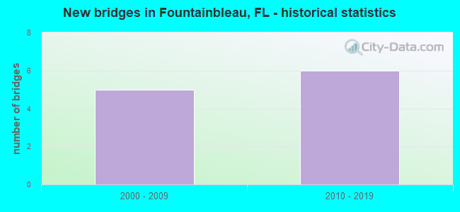
- New bridges - historical statistics
- 52000-2009
- 62010-2019


- Bridge Condition - Superstructure
- 20.0%Excellent
- 80.0%Very good

- Bridge Condition - Substructure
- 20.0%Excellent
- 80.0%Very good
Find on map >> Show street view
Structure Number: 870996, Location: 0.6mi west of NW 107 Av (Lat: 25.778944, Lng: -80.378569), Route carried "on" structure: Ramp State highway 836, Year Built: 2004, Status: Open, Structure Length: 16.09m (52.79ft), Average Daily Traffic: 40,250 (year 2021), Truck Traffic: 3%, Average Future Daily Traffic: 69,834 (year 2042), Design Load: HL 93, Features Intersected: SR 836 Extension
Minimum Vertical Clearance: 30+ m (98+ ft), Kilometerpoint: 4.839, Lanes on structure: 4, Lanes under structure: 5, Base Highway Network: Yes, Toll: On toll road, Owner: State Toll Authority, Approaching Roadway Width: 21.9m (71.9ft), Skew: 3 degrees, Material/Design: Steel continuous, Design/Construction: Box Beam or Girders - Single/Spread, Number Of Spans In Main Unit: 2, Length of Maximum Span: 83.2m (273.0ft), Curb-To-Curb Width: 21.9m (71.9ft), Out-to-Out Width: 22.9m (75.1ft)
Condition: Deck: Very good, Superstructure: Very good, Substructure: Very good, Operating Rating: 39.6 metric tons, Method Used To Determine Operating Rating: Load and Resistance Factor (LRFR), Inventory Rating: 30.4 metric tons, Method Used To Determine Inventory Rating: Load and Resistance Factor (LRFR), Structural Evaluation: Better than present minimum criteria, Deck Geometry: Superior to present desirable criteria, Underclear: Equal to present minimum criteria, Approach Roadway Alignment: Equal to present desirable criteria, Designated Inspection Frequency: Every 24 months, Inspection Date: March 2021, Deck Structure Type: Concrete Cast-file-Place
Find on map >> Show street view
Structure Number: 87101, Location: 3.0 mi. West of SR 826 (Lat: 25.780083, Lng: -80.369028), Route carried "on" structure: State highway 836, Year Built: 2007, Status: Open, Structure Length: 5.19m (17.03ft), Average Daily Traffic: 51,000 (year 2020), Truck Traffic: 4%, Average Future Daily Traffic: 88,485 (year 2042), Design Load: HL 93, Features Intersected: SR 985 (NW 107th Avenue)
Minimum Vertical Clearance: 5.79m (19.00ft), Kilometerpoint: 1.984, Lanes on structure: 6, Lanes under structure: 7, Base Highway Network: Yes, Toll: On toll road, Owner: State Toll Authority, Approaching Roadway Width: 27.3m (89.6ft), Skew: 2 degrees, Material/Design: Prestressed concrete, Design/Construction: Box Beam or Girders - Single/Spread, Number Of Spans In Main Unit: 2, Length of Maximum Span: 26.0m (85.3ft), Curb-To-Curb Width: 29.3m (96.1ft), Out-to-Out Width: 30.2m (99.1ft)
Condition: Deck: Very good, Superstructure: Very good, Substructure: Very good, Operating Rating: 74.1 metric tons, Method Used To Determine Operating Rating: Load and Resistance Factor (LRFR), Inventory Rating: 58.4 metric tons, Method Used To Determine Inventory Rating: Load and Resistance Factor (LRFR), Structural Evaluation: Equal to present desirable criteria, Deck Geometry: Better than present minimum criteria, Underclear: Equal to present minimum criteria, Approach Roadway Alignment: Equal to present desirable criteria, Designated Inspection Frequency: Every 24 months, Inspection Date: September 2020, Deck Structure Type: Concrete Cast-file-Place, Wearing Surface/Protective System: Wearing Surface: Monolithic Concrete
Find on map >> Show street view
Structure Number: 871048, Location: 1.3 Mi S OF SR-836 (Lat: 25.769833, Lng: -80.320294), Route carried "on" structure: State highway 826, Year Built: 2015, Status: Open, Structure Length: 5.22m (17.13ft), Average Daily Traffic: 78,500 (year 2020), Truck Traffic: 6%, Average Future Daily Traffic: 136,198 (year 2042), Design Load: HL 93, Features Intersected: SR 968 (FLAGLER STREET)
Minimum Vertical Clearance: 30.18m (99.02ft), Kilometerpoint: 10.414, Lanes on structure: 8, Lanes under structure: 10, Base Highway Network: Yes, Owner: State Highway Agency, Approaching Roadway Width: 35.4m (116.1ft), Material/Design: Prestressed concrete, Design/Construction: Stringer/Multi-beam, Number Of Spans In Main Unit: 1, Length of Maximum Span: 52.2m (171.3ft), Curb-To-Curb Width: 35.4m (116.1ft), Out-to-Out Width: 36.3m (119.1ft)
Condition: Deck: Very good, Superstructure: Very good, Substructure: Very good, Operating Rating: 49.3 metric tons, Method Used To Determine Operating Rating: Load and Resistance Factor (LRFR), Inventory Rating: 44.7 metric tons, Method Used To Determine Inventory Rating: Load and Resistance Factor (LRFR), Structural Evaluation: Equal to present desirable criteria, Deck Geometry: Equal to present minimum criteria, Underclear: Meets minimum limits, Approach Roadway Alignment: Equal to present desirable criteria, Designated Inspection Frequency: Every 24 months, Inspection Date: April 2021, Deck Structure Type: Concrete Cast-file-Place, Wearing Surface/Protective System: Wearing Surface: Monolithic Concrete
Find on map >> Show street view
Structure Number: 871054, Location: SR 826 & SR 836 Interchan (Lat: 25.780031, Lng: -80.320414), Route carried "on" structure: Ramp State highway 836, Year Built: 2013, Status: Open, Structure Length: 15.69m (51.48ft), Average Daily Traffic: 32,930 (year 2021), Truck Traffic: 6%, Average Future Daily Traffic: 43,600 (year 2042), Design Load: HL 93, Features Intersected: SR 826, Facility Carried by Structure: EBCD Over SR 826
Minimum Vertical Clearance: 5.00m (16.40ft), Kilometerpoint: 9.817, Lanes on structure: 3, Lanes under structure: 12, Base Highway Network: Yes, Toll: On toll road, Owner: State Toll Authority, Approaching Roadway Width: 16.2m (53.1ft), Skew: 1 degrees, Material/Design: Prestressed concrete, Design/Construction: Stringer/Multi-beam, Number Of Spans In Main Unit: 3, Length of Maximum Span: 54.2m (177.8ft), Curb-To-Curb Width: 16.2m (53.1ft), Out-to-Out Width: 16.8m (55.1ft)
Condition: Deck: Very good, Superstructure: Excellent, Substructure: Excellent, Operating Rating: 37.2 metric tons, Method Used To Determine Operating Rating: Load and Resistance Factor (LRFR), Inventory Rating: 32.7 metric tons, Method Used To Determine Inventory Rating: Load and Resistance Factor (LRFR), Structural Evaluation: Superior to present desirable criteria, Deck Geometry: Equal to present minimum criteria, Underclear: Somewhat better than minimum adequacy, Approach Roadway Alignment: Equal to present minimum criteria, Designated Inspection Frequency: Every 24 months, Inspection Date: April 2021, Deck Structure Type: Concrete Cast-file-Place, Wearing Surface/Protective System: Wearing Surface: Monolithic Concrete
Find on map >> Show street view
Structure Number: 871114, Location: 1 Mile West of SR 826 (Lat: 25.781208, Lng: -80.336667), Route carried "on" structure: State highway 836, Year Built: 2017, Status: Open, Structure Length: 5.53m (18.14ft), Average Daily Traffic: 129,300 (year 2021), Truck Traffic: 3%, Average Future Daily Traffic: 224,600 (year 2042), Design Load: HL 93, Features Intersected: SR 973 (NW 87th Ave)
Minimum Vertical Clearance: 30+ m (98+ ft), Kilometerpoint: 9.062, Lanes on structure: 5, Lanes under structure: 11, Base Highway Network: Yes, Toll: On toll road, Owner: State Toll Authority, Approaching Roadway Width: 26.7m (87.6ft), Material/Design: Prestressed concrete, Design/Construction: Stringer/Multi-beam, Number Of Spans In Main Unit: 1, Length of Maximum Span: 55.3m (181.4ft), Curb-To-Curb Width: 26.7m (87.6ft), Out-to-Out Width: 27.5m (90.2ft)
Condition: Deck: Very good, Superstructure: Very good, Substructure: Very good, Operating Rating: 39.6 metric tons, Method Used To Determine Operating Rating: Load and Resistance Factor (LRFR), Inventory Rating: 35.6 metric tons, Method Used To Determine Inventory Rating: Load and Resistance Factor (LRFR), Structural Evaluation: Equal to present desirable criteria, Deck Geometry: Superior to present desirable criteria, Underclear: Better than present minimum criteria, Approach Roadway Alignment: Equal to present desirable criteria, Designated Inspection Frequency: Every 24 months, Inspection Date: June 2021, Deck Structure Type: Concrete Cast-file-Place
Find on map >> Show street view
Structure Number: 870996, Location: 0.6mi west of NW 107 Av (Lat: 25.778944, Lng: -80.378569), Route carried "under" structure: Ramp State highway , Year Built: 2004, Structure Length: 0. m, Average Daily Traffic: 99 (year 2021), Features Intersected: SR 836 Extension, Facility Carried by Structure: SR 836 WB Off Ramp
Minimum Vertical Clearance: 6.43m (21.10ft), Kilometerpoint: 0.000, Lanes on structure: 4, Lanes under structure: 1, Toll: On toll road, Material/Design: Steel continuous, Design/Construction: Box Beam or Girders - Single/Spread, Length of Maximum Span: 83.2m (273.0ft)
Find on map >> Show street view
Structure Number: 870996, Location: 0.6mi west of NW 107 Av (Lat: 25.778944, Lng: -80.378569), Route carried "under" structure: State highway 836, Year Built: 2004, Structure Length: 0. m, Average Daily Traffic: 99 (year 2021), Features Intersected: SR 836 Extension
Minimum Vertical Clearance: 6.43m (21.10ft), Kilometerpoint: 0.000, Lanes on structure: 4, Lanes under structure: 4, Toll: On toll road, Material/Design: Steel continuous, Design/Construction: Box Beam or Girders - Single/Spread, Length of Maximum Span: 83.2m (273.0ft)
Find on map >> Show street view
Structure Number: 87101, Location: 3.0 mi. West of SR 826 (Lat: 25.780083, Lng: -80.369028), Route carried "under" structure: State highway 985, Year Built: 2007, Structure Length: 0. m, Average Daily Traffic: 62,500 (year 2020), Truck Traffic: 4%, Features Intersected: SR 985 (NW 107th Avenue), Facility Carried by Structure: SR 836 EB
Minimum Vertical Clearance: 5.15m (16.90ft), Kilometerpoint: 1.984, Lanes on structure: 6, Lanes under structure: 7, Toll: On toll road, Material/Design: Prestressed concrete, Design/Construction: Box Beam or Girders - Single/Spread, Length of Maximum Span: 26.0m (85.3ft)
Find on map >> Show street view
Structure Number: 871048, Location: 1.3 Mi S OF SR-836 (Lat: 25.769833, Lng: -80.320294), Route carried "under" structure: State highway SR968, Year Built: 2015, Structure Length: 0. m, Average Daily Traffic: 39,000 (year 2020), Truck Traffic: 4%, Features Intersected: SR 968 (FLAGLER STREET), Facility Carried by Structure: SR-826 NB
Minimum Vertical Clearance: 5.06m (16.60ft), Kilometerpoint: 1.598, Lanes on structure: 8, Lanes under structure: 10, Material/Design: Prestressed concrete, Design/Construction: Stringer/Multi-beam, Length of Maximum Span: 52.2m (171.3ft)
Find on map >> Show street view
Structure Number: 871054, Location: SR 826 & SR 836 Interchan (Lat: 25.780031, Lng: -80.320414), Route carried "under" structure: State highway 826, Year Built: 2013, Structure Length: 0. m, Average Daily Traffic: 207,000 (year 2021), Truck Traffic: 6%, Features Intersected: SR 826
Minimum Vertical Clearance: 5.14m (16.86ft), Kilometerpoint: 9.817, Lanes on structure: 3, Lanes under structure: 12, Material/Design: Prestressed concrete, Design/Construction: Stringer/Multi-beam, Length of Maximum Span: 54.2m (177.8ft)
Find on map >> Show street view
Structure Number: 871114, Location: 1 Mile West of SR 826 (Lat: 25.781208, Lng: -80.336667), Route carried "under" structure: County highway 973, Year Built: 2017, Structure Length: 0. m, Average Daily Traffic: 20,180 (year 2021), Features Intersected: SR 973 (NW 87th Ave), Facility Carried by Structure: SR 836 EB
Minimum Vertical Clearance: 6.28m (20.60ft), Kilometerpoint: 15.092, Lanes on structure: 5, Lanes under structure: 11, Material/Design: Prestressed concrete, Design/Construction: Stringer/Multi-beam, Length of Maximum Span: 55.3m (181.4ft)