Bridge Statistics for Farr West, Utah (UT)
Condition, Traffic, Stress, Structural Evaluation, Project Costs
- National Bridge Inventory (NBI) Statistics
- 13Number of bridges
- 79ft / 23.9mTotal length
- 325,945Total average daily traffic
- 71,353Total average daily truck traffic
- National Bridge Inventory (NBI) Registered Bridges for Farr West
- No street view available for this location
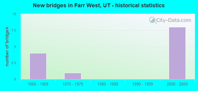
- New bridges - historical statistics
- 41960-1969
- 11970-1979
- 82000-2009


- Bridge Condition - Deck
- 37.5%Good
- 62.5%Satisfactory

- Bridge Condition - Superstructure
- 50.0%Very good
- 37.5%Good
- 12.5%Satisfactory

- Bridge Condition - Channel
- 25.0%Very good
- 50.0%Good
- 25.0%Satisfactory
Find on map >> Show street view
Structure Number: 57002D, Location: 2200 W. & 1900 NO. (Lat: 41.290681, Lng: -112.031950), Route carried "on" structure: City street 3442, Year Built: 1962, Status: Open, Structure Length: 2.79m (9.15ft), Average Daily Traffic: 5,608 (year 2020), Average Future Daily Traffic: 7,010 (year 2040), Design Load: H 15, Features Intersected: WILLARD CANAL, Facility Carried by Structure: FARR WEST CITY ST.
Minimum Vertical Clearance: 30+ m (98+ ft), Kilometerpoint: 5.138, Lanes on structure: 2, Owner: City or Municipal Highway Agency, Approaching Roadway Width: 8.5m (27.9ft), Skew: 6 degrees, Material/Design: Concrete, Design/Construction: Slab, Number Of Spans In Main Unit: 3, Length of Maximum Span: 10.4m (34.1ft), Curb-To-Curb Width: 8.5m (27.9ft), Out-to-Out Width: 9.7m (31.8ft)
Condition: Deck: Good, Superstructure: Good, Substructure: Good, Channel: Good, Operating Rating: 32.4 metric tons, Method Used To Determine Operating Rating: Load and Resistance Factor Rating (LRFR) rating reported by rating factor(RF) method using HL-93 loadings, Inventory Rating: 22.0 metric tons, Method Used To Determine Inventory Rating: Load Factor (LF) rating reported by rating factor (RF) method using MS18 loading, Structural Evaluation: Somewhat better than minimum adequacy, Deck Geometry: High priority of replacement, Waterway Adequacy: Better than present minimum criteria, Approach Roadway Alignment: Equal to present desirable criteria, Designated Inspection Frequency: Every 24 months, Inspection Date: April 2020, Deck Structure Type: Concrete Cast-file-Place, Wearing Surface/Protective System: Wearing Surface: Bituminous
Find on map >> Show street view
Structure Number: 57007D, Location: NORTH PLAIN CITY ROAD (Lat: 41.321114, Lng: -112.035433), Route carried "on" structure: City street 3371, Year Built: 1962, Status: Open, Structure Length: 2.48m (8.14ft), Average Daily Traffic: 909 (year 2020), Average Future Daily Traffic: 1,136 (year 2040), Design Load: H 15, Features Intersected: WILLARD CANAL, Facility Carried by Structure: FARR WEST CITY ST.
Minimum Vertical Clearance: 30+ m (98+ ft), Kilometerpoint: 4.333, Lanes on structure: 2, Owner: City or Municipal Highway Agency, Approaching Roadway Width: 8.0m (26.2ft), Material/Design: Concrete, Design/Construction: Slab, Number Of Spans In Main Unit: 3, Length of Maximum Span: 9.1m (29.9ft), Curb-To-Curb Width: 8.0m (26.2ft), Out-to-Out Width: 9.0m (29.5ft)
Condition: Deck: Satisfactory, Superstructure: Satisfactory, Substructure: Good, Channel: Satisfactory, Operating Rating: 34.0 metric tons, Method Used To Determine Operating Rating: Load and Resistance Factor Rating (LRFR) rating reported by rating factor(RF) method using HL-93 loadings, Inventory Rating: 24.3 metric tons, Method Used To Determine Inventory Rating: Load Factor (LF) rating reported by rating factor (RF) method using MS18 loading, Structural Evaluation: Equal to present minimum criteria, Deck Geometry: Somewhat better than minimum adequacy, Waterway Adequacy: Better than present minimum criteria, Approach Roadway Alignment: Equal to present desirable criteria, Designated Inspection Frequency: Every 24 months, Inspection Date: April 2020, Deck Structure Type: Concrete Cast-file-Place, Wearing Surface/Protective System: Wearing Surface: Bituminous
Find on map >> Show street view
Structure Number: 57008D, Location: 4000 NORTH ROAD (Lat: 41.335814, Lng: -112.038111), Route carried "on" structure: City street 3446, Year Built: 1962, Status: Posted for load, Structure Length: 2.79m (9.15ft), Average Daily Traffic: 1,940 (year 2020), Average Future Daily Traffic: 2,425 (year 2040), Design Load: H 15, Features Intersected: WILLARD CANAL, Facility Carried by Structure: CITY STREET
Minimum Vertical Clearance: 30+ m (98+ ft), Kilometerpoint: 2.953, Lanes on structure: 2, Owner: City or Municipal Highway Agency, Approaching Roadway Width: 8.0m (26.2ft), Skew: 1 degrees, Material/Design: Concrete, Design/Construction: Slab, Number Of Spans In Main Unit: 3, Length of Maximum Span: 10.4m (34.1ft), Curb-To-Curb Width: 8.0m (26.2ft), Out-to-Out Width: 9.0m (29.5ft)
Condition: Deck: Good, Superstructure: Good, Substructure: Good, Channel: Very good, Operating Rating: 16.5 metric tons, Method Used To Determine Operating Rating: Load Factor (LF) rating reported by rating factor (RF) method using MS18 loading, Inventory Rating: 12.6 metric tons, Method Used To Determine Inventory Rating: Load Factor (LF) rating reported by rating factor (RF) method using MS18 loading, Structural Evaluation: Meets minimum limits, Deck Geometry: Meets minimum limits, Waterway Adequacy: Better than present minimum criteria, Approach Roadway Alignment: Equal to present minimum criteria, Bridge Posting: Required (Relationship of Operating Rating to Maximum Legal Load: > 39.9% below), Designated Inspection Frequency: Every 24 months, Inspection Date: April 2020, Deck Structure Type: Concrete Cast-file-Place, Wearing Surface/Protective System: Wearing Surface: Bituminous
Find on map >> Show street view
Structure Number: D 804, Location: 3.2 MI.EAST of PLAIN CITY (Lat: 41.306717, Lng: -112.035031), Route carried "on" structure: State highway 134, Year Built: 1962, Status: Open, Structure Length: 2.46m (8.07ft), Average Daily Traffic: 4,069 (year 2020), Truck Traffic: 19%, Average Future Daily Traffic: 5,086 (year 2040), Design Load: HS 20+Mod, Features Intersected: WILLARD CANAL
Minimum Vertical Clearance: 30+ m (98+ ft), Kilometerpoint: 17.561, Lanes on structure: 2, Owner: State Highway Agency, Approaching Roadway Width: 14.6m (47.9ft), Material/Design: Concrete continuous, Design/Construction: Slab, Number Of Spans In Main Unit: 3, Length of Maximum Span: 9.1m (29.9ft), Curb-To-Curb Width: 14.6m (47.9ft), Out-to-Out Width: 15.6m (51.2ft)
Condition: Deck: Good, Superstructure: Good, Substructure: Good, Channel: Good, Operating Rating: 32.7 metric tons, Method Used To Determine Operating Rating: Load and Resistance Factor Rating (LRFR) rating reported by rating factor(RF) method using HL-93 loadings, Inventory Rating: 32.4 metric tons, Method Used To Determine Inventory Rating: Load and Resistance Factor Rating (LRFR) rating reported by rating factor(RF) method using HL-93 loadings, Structural Evaluation: Better than present minimum criteria, Deck Geometry: Superior to present desirable criteria, Waterway Adequacy: Equal to present minimum criteria, Approach Roadway Alignment: Equal to present desirable criteria, Designated Inspection Frequency: Every 24 months, Inspection Date: May 2021, Deck Structure Type: Concrete Cast-file-Place, Wearing Surface/Protective System: Wearing Surface: Bituminous
Find on map >> Show street view
Structure Number: 1F 748, Location: 1.4Mi.No.Slaterville Int. (Lat: 41.289397, Lng: -112.025864), Route carried "on" structure: Interstate 15, Year Built: 2008, Status: Open, Structure Length: 2.59m (8.50ft), Average Daily Traffic: 60,011 (year 2020), Truck Traffic: 24%, Average Future Daily Traffic: 75,014 (year 2040), Design Load: HL 93, Features Intersected: 1800 NO.ST. in FARR WEST
Minimum Vertical Clearance: 30+ m (98+ ft), Kilometerpoint: 560.843, Lanes on structure: 3, Lanes under structure: 2, Base Highway Network: Yes, Owner: State Highway Agency, Approaching Roadway Width: 18.9m (62.0ft), Skew: 30 degrees, Material/Design: Prestressed concrete, Design/Construction: Stringer/Multi-beam, Number Of Spans In Main Unit: 1, Length of Maximum Span: 25.0m (82.0ft), Curb-To-Curb Width: 18.9m (62.0ft), Out-to-Out Width: 19.8m (65.0ft)
Condition: Deck: Satisfactory, Superstructure: Very good, Substructure: Good, Operating Rating: 52.8 metric tons, Method Used To Determine Operating Rating: Load and Resistance Factor Rating (LRFR) rating reported by rating factor(RF) method using HL-93 loadings, Inventory Rating: 47.6 metric tons, Method Used To Determine Inventory Rating: Load and Resistance Factor Rating (LRFR) rating reported by rating factor(RF) method using HL-93 loadings, Structural Evaluation: Better than present minimum criteria, Deck Geometry: Superior to present desirable criteria, Underclear: Better than present minimum criteria, Approach Roadway Alignment: Equal to present desirable criteria, Designated Inspection Frequency: Every 24 months, Inspection Date: August 2021, Deck Structure Type: Concrete Cast-file-Place, Wearing Surface/Protective System: Wearing Surface: Epoxy Overlay, Deck Protection: Epoxy Coated Reinforcing
Find on map >> Show street view
Structure Number: 1F 749, Location: AT THE HARRISVILLE INTCHG (Lat: 41.306508, Lng: -112.025772), Route carried "on" structure: Interstate 15, Year Built: 2008, Status: Open, Structure Length: 4.11m (13.48ft), Average Daily Traffic: 47,032 (year 2020), Truck Traffic: 25%, Average Future Daily Traffic: 58,790 (year 2040), Design Load: HL 93, Features Intersected: SR-134 (2700 NORTH)
Minimum Vertical Clearance: 5.13m (16.83ft), Kilometerpoint: 562.743, Lanes on structure: 2, Lanes under structure: 6, Base Highway Network: Yes, Owner: State Highway Agency, Approaching Roadway Width: 18.9m (62.0ft), Skew: 30 degrees, Material/Design: Prestressed concrete, Design/Construction: Stringer/Multi-beam, Number Of Spans In Main Unit: 1, Length of Maximum Span: 40.2m (131.9ft), Curb-To-Curb Width: 18.9m (62.0ft), Out-to-Out Width: 19.8m (65.0ft)
Condition: Deck: Satisfactory, Superstructure: Very good, Substructure: Good, Operating Rating: 59.3 metric tons, Method Used To Determine Operating Rating: Load and Resistance Factor Rating (LRFR) rating reported by rating factor(RF) method using HL-93 loadings, Inventory Rating: 53.5 metric tons, Method Used To Determine Inventory Rating: Load and Resistance Factor Rating (LRFR) rating reported by rating factor(RF) method using HL-93 loadings, Structural Evaluation: Better than present minimum criteria, Deck Geometry: Superior to present desirable criteria, Underclear: Equal to present minimum criteria, Approach Roadway Alignment: Equal to present desirable criteria, Designated Inspection Frequency: Every 24 months, Inspection Date: August 2021, Deck Structure Type: Concrete Cast-file-Place, Wearing Surface/Protective System: Wearing Surface: Epoxy Overlay, Deck Protection: Epoxy Coated Reinforcing
Find on map >> Show street view
Structure Number: 3F 748, Location: 1.4Mi.No.Slaterville Int. (Lat: 41.289772, Lng: -112.026050), Route carried "on" structure: Interstate 15, Year Built: 2008, Status: Open, Structure Length: 2.59m (8.50ft), Average Daily Traffic: 60,011 (year 2020), Truck Traffic: 24%, Average Future Daily Traffic: 75,014 (year 2040), Design Load: HL 93, Features Intersected: 1800 NO ST in FARR WEST
Minimum Vertical Clearance: 30+ m (98+ ft), Kilometerpoint: 560.699, Lanes on structure: 3, Lanes under structure: 3, Base Highway Network: Yes, Owner: State Highway Agency, Approaching Roadway Width: 18.9m (62.0ft), Skew: 30 degrees, Material/Design: Prestressed concrete, Design/Construction: Stringer/Multi-beam, Number Of Spans In Main Unit: 1, Length of Maximum Span: 25.0m (82.0ft), Curb-To-Curb Width: 18.9m (62.0ft), Out-to-Out Width: 19.8m (65.0ft)
Condition: Deck: Satisfactory, Superstructure: Very good, Substructure: Good, Operating Rating: 52.8 metric tons, Method Used To Determine Operating Rating: Load and Resistance Factor Rating (LRFR) rating reported by rating factor(RF) method using HL-93 loadings, Inventory Rating: 47.6 metric tons, Method Used To Determine Inventory Rating: Load and Resistance Factor Rating (LRFR) rating reported by rating factor(RF) method using HL-93 loadings, Structural Evaluation: Better than present minimum criteria, Deck Geometry: Superior to present desirable criteria, Underclear: Superior to present desirable criteria, Approach Roadway Alignment: Equal to present desirable criteria, Designated Inspection Frequency: Every 24 months, Inspection Date: August 2021, Deck Structure Type: Concrete Cast-file-Place, Wearing Surface/Protective System: Wearing Surface: Epoxy Overlay, Deck Protection: Epoxy Coated Reinforcing
Find on map >> Show street view
Structure Number: 3F 749, Location: 2700 No.Int.in Farr West (Lat: 41.306869, Lng: -112.026097), Route carried "on" structure: Interstate 15, Year Built: 2008, Status: Open, Structure Length: 4.11m (13.48ft), Average Daily Traffic: 60,011 (year 2020), Truck Traffic: 24%, Average Future Daily Traffic: 75,014 (year 2040), Design Load: HL 93, Features Intersected: SR-134, 2700 NORTH
Minimum Vertical Clearance: 30+ m (98+ ft), Kilometerpoint: 562.597, Lanes on structure: 3, Lanes under structure: 6, Base Highway Network: Yes, Owner: State Highway Agency, Approaching Roadway Width: 18.9m (62.0ft), Skew: 30 degrees, Material/Design: Prestressed concrete, Design/Construction: Stringer/Multi-beam, Number Of Spans In Main Unit: 1, Length of Maximum Span: 40.2m (131.9ft), Curb-To-Curb Width: 18.9m (62.0ft), Out-to-Out Width: 19.8m (65.0ft)
Condition: Deck: Satisfactory, Superstructure: Very good, Substructure: Good, Operating Rating: 51.8 metric tons, Method Used To Determine Operating Rating: Load and Resistance Factor Rating (LRFR) rating reported by rating factor(RF) method using HL-93 loadings, Inventory Rating: 47.3 metric tons, Method Used To Determine Inventory Rating: Load and Resistance Factor Rating (LRFR) rating reported by rating factor(RF) method using HL-93 loadings, Structural Evaluation: Better than present minimum criteria, Deck Geometry: Superior to present desirable criteria, Underclear: Meets minimum limits, Approach Roadway Alignment: Equal to present desirable criteria, Designated Inspection Frequency: Every 24 months, Inspection Date: August 2021, Deck Structure Type: Concrete Cast-file-Place, Wearing Surface/Protective System: Wearing Surface: Epoxy Overlay, Deck Protection: Epoxy Coated Reinforcing
Find on map >> Show street view
Structure Number: C 546, Location: 0.3 Mi.So.Farr West Intch (Lat: 41.296211, Lng: -112.025806), Route carried "under" structure: Interstate 15, Year Built: 1970, Structure Length: 0. m, Average Daily Traffic: 67,000 (year 2020), Truck Traffic: 21%, Features Intersected: I-15 (SR-15) NBL AND SBL, Facility Carried by Structure: FARR W.PED.X-IN.
Minimum Vertical Clearance: 5.12m (16.80ft), Kilometerpoint: 0.000, Lanes under structure: 6, Material/Design: Steel continuous, Design/Construction: Stringer/Multi-beam, Length of Maximum Span: 26.7m (87.6ft)
Find on map >> Show street view
Structure Number: 1F 748, Location: 1.4Mi.No.Slaterville Int. (Lat: 41.289397, Lng: -112.025864), Route carried "under" structure: City street 3442, Year Built: 2008, Structure Length: 0. m, Average Daily Traffic: 5,608 (year 2020), Features Intersected: 1800 NO.ST. in FARR WEST, Facility Carried by Structure: I-15NB (SR-15)
Minimum Vertical Clearance: 4.98m (16.34ft), Kilometerpoint: 0.000, Lanes on structure: 3, Lanes under structure: 2, Material/Design: Prestressed concrete, Design/Construction: Stringer/Multi-beam, Length of Maximum Span: 25.0m (82.0ft)
Find on map >> Show street view
Structure Number: 1F 749, Location: AT THE HARRISVILLE INTCHG (Lat: 41.306508, Lng: -112.025772), Route carried "under" structure: State highway 134, Year Built: 2008, Structure Length: 0. m, Average Daily Traffic: 4,069 (year 2020), Truck Traffic: 19%, Features Intersected: SR-134 (2700 NORTH), Facility Carried by Structure: I-15 NB, (SR-15)
Minimum Vertical Clearance: 5.13m (16.83ft), Kilometerpoint: 18.256, Lanes on structure: 2, Lanes under structure: 6, Material/Design: Prestressed concrete, Design/Construction: Stringer/Multi-beam, Length of Maximum Span: 40.2m (131.9ft)
Find on map >> Show street view
Structure Number: 3F 748, Location: 1.4Mi.No.Slaterville Int. (Lat: 41.289772, Lng: -112.026050), Route carried "under" structure: City street 3442, Year Built: 2008, Structure Length: 0. m, Average Daily Traffic: 5,608 (year 2020), Features Intersected: 1800 NO ST in FARR WEST, Facility Carried by Structure: I-15 (SR-15) SBL
Minimum Vertical Clearance: 5.13m (16.83ft), Kilometerpoint: 0.000, Lanes on structure: 3, Lanes under structure: 2, Material/Design: Prestressed concrete, Design/Construction: Stringer/Multi-beam, Length of Maximum Span: 25.0m (82.0ft)
Find on map >> Show street view
Structure Number: 3F 749, Location: 2700 No.Int.in Farr West (Lat: 41.306869, Lng: -112.026097), Route carried "under" structure: State highway 134, Year Built: 2008, Structure Length: 0. m, Average Daily Traffic: 4,069 (year 2020), Truck Traffic: 19%, Features Intersected: SR-134, 2700 NORTH, Facility Carried by Structure: I-15 (SR-15) SBL
Minimum Vertical Clearance: 5.33m (17.49ft), Kilometerpoint: 18.226, Lanes on structure: 3, Lanes under structure: 6, Material/Design: Prestressed concrete, Design/Construction: Stringer/Multi-beam, Length of Maximum Span: 40.2m (131.9ft)