Bridge Statistics for Dearborn Heights, Michigan (MI)
Condition, Traffic, Stress, Structural Evaluation, Project Costs
- National Bridge Inventory (NBI) Statistics
- 37Number of bridges
- 279ft / 85.2mTotal length
- $559,000Total costs
- 598,033Total average daily traffic
- 32,056Total average daily truck traffic
- National Bridge Inventory (NBI) Registered Bridges for Dearborn Heights
- No street view available for this location
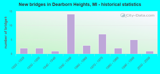
- New bridges - historical statistics
- 21920-1929
- 21930-1939
- 11940-1949
- 141950-1959
- 31960-1969
- 71970-1979
- 21980-1989
- 51990-1999
- 12000-2009
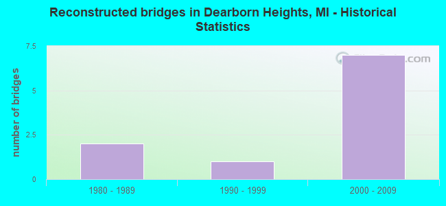
- Reconstructed bridges - Historical Statistics
- 21980-1989
- 11990-1999
- 72000-2009
- Bridge Condition - Deck
- 3.7%Excellent
- 11.1%Very good
- 22.2%Good
- 22.2%Satisfactory
- 29.6%Fair
- 7.4%Poor
- 3.7%Serious
- Bridge Condition - Superstructure
- 3.7%Excellent
- 18.5%Very good
- 37.0%Good
- 14.8%Satisfactory
- 18.5%Fair
- 3.7%Poor
- 3.7%Serious
- Bridge Condition - Substructure
- 7.4%Very good
- 33.3%Good
- 44.4%Satisfactory
- 7.4%Fair
- 7.4%Poor
- Bridge Condition - Channel
- 11.5%Very good
- 19.2%Good
- 19.2%Satisfactory
- 42.3%Fair
- 7.7%Poor
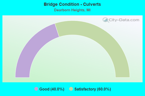
- Bridge Condition - Culverts
- 40.0%Good
- 60.0%Satisfactory
Find on map >> Show street view
Structure Number: 1128, Location: MATTESON TWP SEC 35-36 (Lat: 41.909050, Lng: -85.195186), Route carried "on" structure: County highway 1225, Year Built: 2004, Status: Open, Structure Length: 1.95m (6.40ft), Average Daily Traffic: 2,698 (year 2004), Truck Traffic: 4%, Average Future Daily Traffic: 3,310 (year 2024), Design Load: HS 20, Features Intersected: SWAN CREEK DRAIN #5100, Facility Carried by Structure: MATTESON LAKE ROAD
Minimum Vertical Clearance: 30.48m (100.00ft), Kilometerpoint: 16.599, Lanes on structure: 2, Owner: County Highway Agency, Approaching Roadway Width: 9.1m (29.9ft), Material/Design: Prestressed concrete, Design/Construction: Box Beam or Girders - Multiple, Number Of Spans In Main Unit: 1, Length of Maximum Span: 18.9m (62.0ft), Curb-To-Curb Width: 11.6m (38.1ft), Out-to-Out Width: 11.9m (39.0ft)
Condition: Deck: Good, Superstructure: Good, Substructure: Very good, Channel: Good, Operating Rating: 84.8 metric tons, Method Used To Determine Operating Rating: Load Factor (LF), Inventory Rating: 50.8 metric tons, Method Used To Determine Inventory Rating: Load Factor (LF), Structural Evaluation: Better than present minimum criteria, Deck Geometry: Somewhat better than minimum adequacy, Waterway Adequacy: Equal to present desirable criteria, Approach Roadway Alignment: Equal to present desirable criteria, Designated Inspection Frequency: Every 24 months, Inspection Date: October 2020, Deck Structure Type: Concrete Cast-file-Place, Wearing Surface/Protective System: Wearing Surface: Integral Concrete, Deck Protection: Epoxy Coated Reinforcing
Find on map >> Show street view
Structure Number: 1233, Location: @ I-94 (Lat: 42.297611, Lng: -84.996906), Route carried "on" structure: Ramp Interstate 69, Year Built: 1968, Year Reconstructed: 2008, Status: Open, Structure Length: 10.85m (35.60ft), Average Daily Traffic: 11,679 (year 2007), Truck Traffic: 34%, Average Future Daily Traffic: 25,600 (year 2027), Design Load: HS 20+Mod, Features Intersected: I-94
Minimum Vertical Clearance: 30.48m (100.00ft), Kilometerpoint: 25.905, Lanes on structure: 2, Lanes under structure: 8, Owner: State Highway Agency, Approaching Roadway Width: 9.9m (32.5ft), Material/Design: Steel, Design/Construction: Stringer/Multi-beam, Number Of Spans In Main Unit: 4, Length of Maximum Span: 28.3m (92.8ft), Curb-To-Curb Width: 9.8m (32.2ft), Out-to-Out Width: 10.6m (34.8ft)
Condition: Deck: Satisfactory, Superstructure: Fair, Substructure: Satisfactory, Operating Rating: 59.0 metric tons, Method Used To Determine Operating Rating: Load Factor (LF) rating reported by rating factor (RF) method using MS18 loading, Inventory Rating: 35.3 metric tons, Method Used To Determine Inventory Rating: Load Factor (LF) rating reported by rating factor (RF) method using MS18 loading, Structural Evaluation: Somewhat better than minimum adequacy, Deck Geometry: Equal to present minimum criteria, Underclear: Equal to present minimum criteria, Approach Roadway Alignment: Equal to present desirable criteria, Designated Inspection Frequency: Every 24 months, Inspection Date: June 2021, Deck Structure Type: Concrete Cast-file-Place, Wearing Surface/Protective System: Wearing Surface: Latex Concrete
Find on map >> Show street view
Structure Number: 11279, Location: IN DEARBORN HTS (Lat: 42.271408, Lng: -83.270147), Route carried "on" structure: US 24, Year Built: 1987, Status: Open, Structure Length: 1.00m (3.28ft), Average Daily Traffic: 31,002 (year 2007), Truck Traffic: 7%, Average Future Daily Traffic: 21,959 (year 2018), Design Load: HS 25 or greater, Features Intersected: ECORSE CREEK
Minimum Vertical Clearance: 30.48m (100.00ft), Kilometerpoint: 20.261, Lanes on structure: 4, Base Highway Network: Yes (Inventory Route: 470, Subroute: 38), Owner: State Highway Agency, Approaching Roadway Width: 16.4m (53.8ft), Skew: 2 degrees, Material/Design: Prestressed concrete, Design/Construction: Stringer/Multi-beam, Number Of Spans In Main Unit: 1, Length of Maximum Span: 10.0m (32.8ft), Curb or Sidewalk Widths: Left: 0.0m, Right: 3.3m (10.8ft), Curb-To-Curb Width: 16.4m (53.8ft), Out-to-Out Width: 20.7m (67.9ft)
Condition: Deck: Good, Superstructure: Very good, Substructure: Good, Channel: Good, Operating Rating: 61.2 metric tons, Method Used To Determine Operating Rating: Load Factor (LF) rating reported by rating factor (RF) method using MS18 loading, Inventory Rating: 29.8 metric tons, Method Used To Determine Inventory Rating: Load Factor (LF) rating reported by rating factor (RF) method using MS18 loading, Structural Evaluation: Better than present minimum criteria, Deck Geometry: Meets minimum limits, Waterway Adequacy: Equal to present desirable criteria, Approach Roadway Alignment: Equal to present desirable criteria, Designated Inspection Frequency: Every 24 months, Inspection Date: August 2020, Deck Structure Type: Concrete Cast-file-Place, Wearing Surface/Protective System: Wearing Surface: Epoxy Overlay, Deck Protection: Epoxy Coated Reinforcing
Find on map >> Show street view
Structure Number: 1128, Location: IN DEARBORN HTS (Lat: 42.271450, Lng: -83.270592), Route carried "on" structure: US 24, Year Built: 1958, Year Reconstructed: 1990, Status: Open, Structure Length: 0.94m (3.08ft), Average Daily Traffic: 31,002 (year 2007), Truck Traffic: 7%, Average Future Daily Traffic: 21,959 (year 2018), Design Load: HS 20, Features Intersected: ECORSE CREEK
Minimum Vertical Clearance: 30.48m (100.00ft), Kilometerpoint: 9.186, Lanes on structure: 3, Base Highway Network: Yes (Inventory Route: 157, Subroute: 6), Owner: State Highway Agency, Approaching Roadway Width: 17.3m (56.8ft), Material/Design: Concrete, Design/Construction: Tee Beam, Number Of Spans In Main Unit: 1, Length of Maximum Span: 9.4m (30.8ft), Curb or Sidewalk Widths: Left: 2.4m (7.9ft), Right: 0.0m, Curb-To-Curb Width: 16.4m (53.8ft), Out-to-Out Width: 19.7m (64.6ft)
Condition: Deck: Fair, Superstructure: Fair, Substructure: Good, Channel: Good, Operating Rating: 47.6 metric tons, Method Used To Determine Operating Rating: Load Factor (LF) rating reported by rating factor (RF) method using MS18 loading, Inventory Rating: 28.5 metric tons, Method Used To Determine Inventory Rating: Load Factor (LF) rating reported by rating factor (RF) method using MS18 loading, Structural Evaluation: Somewhat better than minimum adequacy, Deck Geometry: Better than present minimum criteria, Waterway Adequacy: Equal to present desirable criteria, Approach Roadway Alignment: Equal to present desirable criteria, Designated Inspection Frequency: Every 24 months, Inspection Date: August 2020, Deck Structure Type: Concrete Cast-file-Place, Wearing Surface/Protective System: Wearing Surface: Latex Concrete
Find on map >> Show street view
Structure Number: 11288, Location: IN DEARBORN HTS (Lat: 42.344167, Lng: -83.273306), Route carried "on" structure: US 24, Year Built: 1959, Year Reconstructed: 2006, Status: Open, Structure Length: 3.78m (12.40ft), Average Daily Traffic: 27,634 (year 2007), Truck Traffic: 6%, Average Future Daily Traffic: 33,750 (year 2025), Design Load: HS 25 or greater, Features Intersected: MIDDLE ROUGE R
Minimum Vertical Clearance: 30.48m (100.00ft), Kilometerpoint: 28.348, Lanes on structure: 4, Base Highway Network: Yes (Inventory Route: 470, Subroute: 38), Owner: State Highway Agency, Approaching Roadway Width: 15.8m (51.8ft), Skew: 13 degrees, Material/Design: Prestressed concrete, Design/Construction: Box Beam or Girders - Single/Spread, Number Of Spans In Main Unit: 2, Length of Maximum Span: 18.0m (59.1ft), Curb or Sidewalk Widths: Left: 0.0m, Right: 2.2m (7.2ft), Curb-To-Curb Width: 17.1m (56.1ft), Out-to-Out Width: 20.3m (66.6ft)
Condition: Deck: Very good, Superstructure: Very good, Substructure: Good, Channel: Poor, Operating Rating: 54.4 metric tons, Method Used To Determine Operating Rating: Load Factor (LF) rating reported by rating factor (RF) method using MS18 loading, Inventory Rating: 25.9 metric tons, Method Used To Determine Inventory Rating: Load Factor (LF) rating reported by rating factor (RF) method using MS18 loading, Structural Evaluation: Equal to present minimum criteria, Deck Geometry: Somewhat better than minimum adequacy, Waterway Adequacy: Equal to present desirable criteria, Approach Roadway Alignment: Equal to present desirable criteria, Designated Inspection Frequency: Every 24 months, Inspection Date: August 2020, Deck Structure Type: Concrete Cast-file-Place, Wearing Surface/Protective System: Wearing Surface: Monolithic Concrete, Deck Protection: Epoxy Coated Reinforcing
Find on map >> Show street view
Structure Number: 11289, Location: IN DEARBORN HTS (Lat: 42.344367, Lng: -83.273756), Route carried "on" structure: US 24, Year Built: 1959, Year Reconstructed: 2006, Status: Open, Structure Length: 3.78m (12.40ft), Average Daily Traffic: 27,634 (year 2007), Truck Traffic: 6%, Average Future Daily Traffic: 33,750 (year 2026), Design Load: HS 25 or greater, Features Intersected: MIDDLE ROUGE R
Minimum Vertical Clearance: 30.48m (100.00ft), Kilometerpoint: 17.293, Lanes on structure: 4, Base Highway Network: Yes (Inventory Route: 157, Subroute: 6), Owner: State Highway Agency, Approaching Roadway Width: 15.2m (49.9ft), Skew: 13 degrees, Material/Design: Prestressed concrete, Design/Construction: Box Beam or Girders - Single/Spread, Number Of Spans In Main Unit: 2, Length of Maximum Span: 18.9m (62.0ft), Curb or Sidewalk Widths: Left: 0.0m, Right: 2.2m (7.2ft), Curb-To-Curb Width: 17.1m (56.1ft), Out-to-Out Width: 20.3m (66.6ft)
Condition: Deck: Very good, Superstructure: Very good, Substructure: Good, Channel: Poor, Operating Rating: 54.8 metric tons, Method Used To Determine Operating Rating: Load Factor (LF) rating reported by rating factor (RF) method using MS18 loading, Inventory Rating: 31.8 metric tons, Method Used To Determine Inventory Rating: Load Factor (LF) rating reported by rating factor (RF) method using MS18 loading, Structural Evaluation: Better than present minimum criteria, Deck Geometry: Somewhat better than minimum adequacy, Waterway Adequacy: Better than present minimum criteria, Approach Roadway Alignment: Equal to present desirable criteria, Designated Inspection Frequency: Every 24 months, Inspection Date: August 2020, Deck Structure Type: Concrete Cast-file-Place, Wearing Surface/Protective System: Wearing Surface: Monolithic Concrete, Deck Protection: Epoxy Coated Reinforcing
Find on map >> Show street view
Structure Number: 11295, Location: IN DEARBORN HTS (Lat: 42.346361, Lng: -83.273881), Route carried "on" structure: US 24, Year Built: 1959, Year Reconstructed: 2006, Status: Open, Structure Length: 4.16m (13.65ft), Average Daily Traffic: 27,634 (year 2007), Truck Traffic: 6%, Average Future Daily Traffic: 33,750 (year 2025), Design Load: HS 20+Mod, Features Intersected: HINES DRIVE
Minimum Vertical Clearance: 30.48m (100.00ft), Kilometerpoint: 17.515, Lanes on structure: 3, Lanes under structure: 2, Base Highway Network: Yes (Inventory Route: 157, Subroute: 6), Owner: State Highway Agency, Approaching Roadway Width: 16.8m (55.1ft), Skew: 3 degrees, Material/Design: Prestressed concrete, Design/Construction: Box Beam or Girders - Multiple, Number Of Spans In Main Unit: 3, Length of Maximum Span: 19.0m (62.3ft), Curb or Sidewalk Widths: Left: 2.3m (7.5ft), Right: 0.0m, Curb-To-Curb Width: 17.3m (56.8ft), Out-to-Out Width: 20.5m (67.3ft)
Condition: Deck: Good, Superstructure: Very good, Substructure: Good, Operating Rating: 77.1 metric tons, Method Used To Determine Operating Rating: Load Factor (LF) rating reported by rating factor (RF) method using MS18 loading, Inventory Rating: 45.7 metric tons, Method Used To Determine Inventory Rating: Load Factor (LF) rating reported by rating factor (RF) method using MS18 loading, Structural Evaluation: Better than present minimum criteria, Deck Geometry: Superior to present desirable criteria, Underclear: Equal to present minimum criteria, Approach Roadway Alignment: Equal to present desirable criteria, Designated Inspection Frequency: Every 24 months, Inspection Date: August 2020, Deck Structure Type: Concrete Cast-file-Place, Wearing Surface/Protective System: Wearing Surface: Monolithic Concrete, Deck Protection: Epoxy Coated Reinforcing
Find on map >> Show street view
Structure Number: 11296, Location: IN DEARBORN HTS (Lat: 42.346192, Lng: -83.273433), Route carried "on" structure: US 24, Year Built: 1959, Year Reconstructed: 2006, Status: Open, Structure Length: 4.17m (13.68ft), Average Daily Traffic: 27,634 (year 2007), Truck Traffic: 6%, Average Future Daily Traffic: 33,750 (year 2025), Design Load: HS 20+Mod, Features Intersected: HINES DRIVE
Minimum Vertical Clearance: 30.48m (100.00ft), Kilometerpoint: 28.573, Lanes on structure: 4, Lanes under structure: 2, Base Highway Network: Yes (Inventory Route: 470, Subroute: 38), Owner: State Highway Agency, Approaching Roadway Width: 15.2m (49.9ft), Skew: 3 degrees, Material/Design: Prestressed concrete, Design/Construction: Box Beam or Girders - Multiple, Number Of Spans In Main Unit: 3, Length of Maximum Span: 19.0m (62.3ft), Curb or Sidewalk Widths: Left: 0.0m, Right: 2.3m (7.5ft), Curb-To-Curb Width: 17.2m (56.4ft), Out-to-Out Width: 20.5m (67.3ft)
Condition: Deck: Good, Superstructure: Very good, Substructure: Good, Operating Rating: 82.3 metric tons, Method Used To Determine Operating Rating: Load Factor (LF) rating reported by rating factor (RF) method using MS18 loading, Inventory Rating: 44.7 metric tons, Method Used To Determine Inventory Rating: Load Factor (LF) rating reported by rating factor (RF) method using MS18 loading, Structural Evaluation: Better than present minimum criteria, Deck Geometry: Somewhat better than minimum adequacy, Underclear: Equal to present minimum criteria, Approach Roadway Alignment: Equal to present desirable criteria, Designated Inspection Frequency: Every 24 months, Inspection Date: August 2020, Deck Structure Type: Concrete Cast-file-Place, Wearing Surface/Protective System: Wearing Surface: Monolithic Concrete, Deck Protection: Epoxy Coated Reinforcing
Find on map >> Show street view
Structure Number: 11328, Location: IN DEARBORN (Lat: 42.328400, Lng: -83.241097), Route carried "on" structure: State highway 153, Year Built: 1971, Status: Open, Structure Length: 8.84m (29.00ft), Average Daily Traffic: 35,830 (year 2014), Truck Traffic: 1%, Average Future Daily Traffic: 41,205 (year 2034), Design Load: HS 20, Features Intersected: ROUGE RIVER
Minimum Vertical Clearance: 30+ m (98+ ft), Kilometerpoint: 2.078, Lanes on structure: 4, Base Highway Network: Yes (Inventory Route: 192, Subroute: 7), Owner: State Highway Agency, Approaching Roadway Width: 18.9m (62.0ft), Skew: 3 degrees, Material/Design: Steel, Design/Construction: Stringer/Multi-beam, Number Of Spans In Main Unit: 3, Length of Maximum Span: 33.5m (109.9ft), Curb or Sidewalk Widths: Left: 2.9m (9.5ft), Right: 0.0m, Curb-To-Curb Width: 17.2m (56.4ft), Out-to-Out Width: 20.1m (65.9ft)
Condition: Deck: Satisfactory, Superstructure: Satisfactory, Substructure: Satisfactory, Channel: Very good, Operating Rating: 75.8 metric tons, Method Used To Determine Operating Rating: Load Factor (LF) rating reported by rating factor (RF) method using MS18 loading, Inventory Rating: 45.4 metric tons, Method Used To Determine Inventory Rating: Load Factor (LF) rating reported by rating factor (RF) method using MS18 loading, Structural Evaluation: Equal to present minimum criteria, Deck Geometry: Somewhat better than minimum adequacy, Waterway Adequacy: Equal to present desirable criteria, Approach Roadway Alignment: Equal to present desirable criteria, Designated Inspection Frequency: Every 24 months, Underwater Inspection Frequency: Every 60 months, Inspection Date: May 2020, Underwater Inspection Date: April 2020, Bridge Improvement Cost: $611,000, Deck Structure Type: Concrete Cast-file-Place, Wearing Surface/Protective System: Wearing Surface: Latex Concrete
Find on map >> Show street view
Structure Number: 11337, Location: DEARBORN HG OVER HINES DR (Lat: 42.327611, Lng: -83.245142), Route carried "on" structure: State highway 153, Year Built: 1971, Year Reconstructed: 2005, Status: Open, Structure Length: 5.12m (16.80ft), Average Daily Traffic: 30,070 (year 2007), Truck Traffic: 2%, Average Future Daily Traffic: 43,011 (year 2018), Design Load: HS 20, Features Intersected: HINES DRIVE
Minimum Vertical Clearance: 30+ m (98+ ft), Kilometerpoint: 1.733, Lanes on structure: 4, Lanes under structure: 5, Base Highway Network: Yes (Inventory Route: 192, Subroute: 7), Owner: State Highway Agency, Approaching Roadway Width: 18.9m (62.0ft), Skew: 1 degrees, Material/Design: Steel, Design/Construction: Stringer/Multi-beam, Number Of Spans In Main Unit: 2, Length of Maximum Span: 26.8m (87.9ft), Curb-To-Curb Width: 18.9m (62.0ft), Out-to-Out Width: 20.1m (65.9ft)
Condition: Deck: Poor, Superstructure: Good, Substructure: Good, Operating Rating: 64.8 metric tons, Method Used To Determine Operating Rating: Load Factor (LF) rating reported by rating factor (RF) method using MS18 loading, Inventory Rating: 38.9 metric tons, Method Used To Determine Inventory Rating: Load Factor (LF) rating reported by rating factor (RF) method using MS18 loading, Structural Evaluation: Better than present minimum criteria, Deck Geometry: Equal to present minimum criteria, Underclear: Meets minimum limits, Approach Roadway Alignment: Equal to present desirable criteria, Length Of Structure Improvement: 5.12m (16.80ft), Designated Inspection Frequency: Every 12 months, Inspection Date: May 2021, Bridge Improvement Cost: $418,000, Roadway Improvement Cost: $39,000, Total Project Cost: $463,000, Deck Structure Type: Concrete Cast-file-Place, Wearing Surface/Protective System: Wearing Surface: Latex Concrete
Find on map >> Show street view
Structure Number: 12054, Location: DBN HTS W/ANN ARBR TRAIL (Lat: 42.341692, Lng: -83.263917), Route carried "on" structure: County highway 2057, Year Built: 1929, Status: Temporarily open, Structure Length: 2.68m (8.79ft), Average Daily Traffic: 16,260 (year 2014), Truck Traffic: 7%, Average Future Daily Traffic: 16,425 (year 2034), Design Load: HS 20+Mod, Features Intersected: MIDDLE ROUGE RIVER, Facility Carried by Structure: WARREN ROAD
Minimum Vertical Clearance: 30.48m (100.00ft), Kilometerpoint: 23.943, Lanes on structure: 5, Base Highway Network: Yes (Inventory Route: 471, Subroute: 70), Owner: County Highway Agency, Approaching Roadway Width: 18.7m (61.4ft), Material/Design: Concrete, Design/Construction: Tee Beam, Number Of Spans In Main Unit: 2, Length of Maximum Span: 12.8m (42.0ft), Curb or Sidewalk Widths: Left: 2.4m (7.9ft), Right: 2.4m (7.9ft), Curb-To-Curb Width: 14.6m (47.9ft), Out-to-Out Width: 24.3m (79.7ft)
Condition: Deck: Serious, Superstructure: Serious, Substructure: Poor, Channel: Fair, Operating Rating: 8.4 metric tons, Method Used To Determine Operating Rating: Load Factor (LF) rating reported by rating factor (RF) method using MS18 loading, Inventory Rating: 5.2 metric tons, Method Used To Determine Inventory Rating: Load Factor (LF) rating reported by rating factor (RF) method using MS18 loading, Structural Evaluation: High priority of corrective action, Deck Geometry: High priority of replacement, Waterway Adequacy: Equal to present desirable criteria, Approach Roadway Alignment: Equal to present desirable criteria, Designated Inspection Frequency: Every 12 months, Inspection Date: June 2021, Deck Structure Type: Concrete Cast-file-Place, Wearing Surface/Protective System: Wearing Surface: Bituminous, Membrane: Preformed Fabric
Find on map >> Show street view
Structure Number: 12056, Location: DBN HT/DETROIT E/OUTER DR (Lat: 42.342397, Lng: -83.248861), Route carried "on" structure: County highway 2057, Year Built: 1930, Year Reconstructed: 1992, Status: Open, Structure Length: 3.32m (10.89ft), Average Daily Traffic: 18,921 (year 1997), Truck Traffic: 7%, Average Future Daily Traffic: 23,121 (year 2015), Design Load: HS 20+Mod, Features Intersected: UPPER ROUGE RIVER, Facility Carried by Structure: WARREN AVENUE
Minimum Vertical Clearance: 30.48m (100.00ft), Kilometerpoint: 1.106, Lanes on structure: 6, Base Highway Network: Yes (Inventory Route: 159, Subroute: 4), Owner: County Highway Agency, Approaching Roadway Width: 18.2m (59.7ft), Skew: 3 degrees, Material/Design: Steel, Design/Construction: Stringer/Multi-beam, Number Of Spans In Main Unit: 2, Length of Maximum Span: 15.8m (51.8ft), Curb or Sidewalk Widths: Left: 3.1m (10.2ft), Right: 3.1m (10.2ft), Curb-To-Curb Width: 18.2m (59.7ft), Out-to-Out Width: 25.3m (83.0ft)
Condition: Deck: Satisfactory, Superstructure: Fair, Substructure: Satisfactory, Channel: Satisfactory, Operating Rating: 52.2 metric tons, Method Used To Determine Operating Rating: Load Factor (LF) rating reported by rating factor (RF) method using MS18 loading, Inventory Rating: 31.4 metric tons, Method Used To Determine Inventory Rating: Load Factor (LF) rating reported by rating factor (RF) method using MS18 loading, Structural Evaluation: Somewhat better than minimum adequacy, Deck Geometry: High priority of replacement, Waterway Adequacy: Equal to present desirable criteria, Approach Roadway Alignment: Equal to present desirable criteria, Designated Inspection Frequency: Every 24 months, Inspection Date: September 2020, Deck Structure Type: Concrete Cast-file-Place, Wearing Surface/Protective System: Wearing Surface: Latex Concrete, Deck Protection: Epoxy Coated Reinforcing
Find on map >> Show street view
Structure Number: 12073, Location: DBN HTS N/FORD (Lat: 42.330750, Lng: -83.247950), Route carried "on" structure: County highway 2057, Year Built: 1961, Status: Posted for load, Structure Length: 3.23m (10.60ft), Average Daily Traffic: 15,754 (year 1996), Average Future Daily Traffic: 13,767 (year 2015), Design Load: HS 20+Mod, Features Intersected: MIDDLE ROUGE RIVER, Facility Carried by Structure: E N HINES DRIVE
Minimum Vertical Clearance: 30.48m (100.00ft), Kilometerpoint: 23.819, Lanes on structure: 2, Base Highway Network: Yes (Inventory Route: 168, Subroute: 9), Owner: County Highway Agency, Approaching Roadway Width: 13.4m (44.0ft), Skew: 3 degrees, Material/Design: Concrete continuous, Design/Construction: Slab, Number Of Spans In Main Unit: 4, Length of Maximum Span: 8.8m (28.9ft), Curb or Sidewalk Widths: Left: 2.4m (7.9ft), Right: 2.4m (7.9ft), Curb-To-Curb Width: 14.6m (47.9ft), Out-to-Out Width: 20.1m (65.9ft)
Condition: Deck: Poor, Superstructure: Poor, Substructure: Satisfactory, Channel: Fair, Operating Rating: 37.6 metric tons, Method Used To Determine Operating Rating: Load Factor (LF) rating reported by rating factor (RF) method using MS18 loading, Inventory Rating: 22.7 metric tons, Method Used To Determine Inventory Rating: Load Factor (LF) rating reported by rating factor (RF) method using MS18 loading, Structural Evaluation: Meets minimum limits, Deck Geometry: Superior to present desirable criteria, Waterway Adequacy: Equal to present desirable criteria, Approach Roadway Alignment: Equal to present desirable criteria, Bridge Posting: Required (Relationship of Operating Rating to Maximum Legal Load: 10.0 - 19.9% below), Designated Inspection Frequency: Every 12 months, Inspection Date: June 2021, Deck Structure Type: Concrete Cast-file-Place, Wearing Surface/Protective System: Wearing Surface: Bituminous, Membrane: Built-up
Find on map >> Show street view
Structure Number: 12074, Location: DBN HTS N/WARREN (Lat: 42.351269, Lng: -83.293567), Route carried "on" structure: County highway 2057, Year Built: 1953, Status: Open, Structure Length: 2.16m (7.09ft), Average Daily Traffic: 15,190 (year 1996), Average Future Daily Traffic: 14,709 (year 2015), Design Load: HS 20, Features Intersected: BEECH-DALY ROAD, Facility Carried by Structure: E.N.HINES DR/AA TR
Minimum Vertical Clearance: 30.48m (100.00ft), Kilometerpoint: 18.965, Lanes on structure: 4, Lanes under structure: 4, Owner: County Highway Agency, Approaching Roadway Width: 14.3m (46.9ft), Material/Design: Steel, Design/Construction: Stringer/Multi-beam, Number Of Spans In Main Unit: 1, Length of Maximum Span: 21.0m (68.9ft), Curb or Sidewalk Widths: Left: 1.5m (4.9ft), Right: 1.5m (4.9ft), Curb-To-Curb Width: 14.6m (47.9ft), Out-to-Out Width: 19.0m (62.3ft)
Condition: Deck: Fair, Superstructure: Satisfactory, Substructure: Satisfactory, Operating Rating: 70.0 metric tons, Method Used To Determine Operating Rating: Load Factor (LF) rating reported by rating factor (RF) method using MS18 loading, Inventory Rating: 41.8 metric tons, Method Used To Determine Inventory Rating: Load Factor (LF) rating reported by rating factor (RF) method using MS18 loading, Structural Evaluation: Equal to present minimum criteria, Deck Geometry: High priority of replacement, Underclear: Meets minimum limits, Approach Roadway Alignment: Equal to present desirable criteria, Designated Inspection Frequency: Every 24 months, Inspection Date: September 2020, Deck Structure Type: Concrete Cast-file-Place, Wearing Surface/Protective System: Wearing Surface: Bituminous
Find on map >> Show street view
Structure Number: 12168, Location: DBN HTS/WESTLAND S/AA TR (Lat: 42.348258, Lng: -83.312508), Route carried "on" structure: County highway 2057, Year Built: 1930, Status: Open, Structure Length: 2.65m (8.69ft), Average Daily Traffic: 30,856 (year 1996), Truck Traffic: 5%, Average Future Daily Traffic: 27,933 (year 2015), Features Intersected: MIDDLE ROUGE RIVER, Facility Carried by Structure: INKSTER ROAD
Minimum Vertical Clearance: 30.48m (100.00ft), Kilometerpoint: 26.768, Lanes on structure: 4, Owner: County Highway Agency, Approaching Roadway Width: 14.6m (47.9ft), Material/Design: Concrete, Design/Construction: Tee Beam, Number Of Spans In Main Unit: 2, Length of Maximum Span: 12.8m (42.0ft), Curb or Sidewalk Widths: Left: 1.1m (3.6ft), Right: 1.1m (3.6ft), Curb-To-Curb Width: 14.0m (45.9ft), Out-to-Out Width: 17.0m (55.8ft)
Condition: Deck: Satisfactory, Superstructure: Satisfactory, Substructure: Satisfactory, Channel: Fair, Operating Rating: 53.5 metric tons, Method Used To Determine Operating Rating: Load Factor (LF) rating reported by rating factor (RF) method using MS18 loading, Inventory Rating: 32.1 metric tons, Method Used To Determine Inventory Rating: Load Factor (LF) rating reported by rating factor (RF) method using MS18 loading, Structural Evaluation: Equal to present minimum criteria, Deck Geometry: High priority of replacement, Waterway Adequacy: Equal to present desirable criteria, Approach Roadway Alignment: Equal to present desirable criteria, Designated Inspection Frequency: Every 24 months, Inspection Date: September 2020, Deck Structure Type: Concrete Cast-file-Place, Wearing Surface/Protective System: Wearing Surface: Integral Concrete, Deck Protection: Epoxy Coated Reinforcing
Find on map >> Show street view
Structure Number: 12169, Location: DBNHTS/WESTLDS/JOY (Lat: 42.349411, Lng: -83.312558), Route carried "on" structure: County highway 2057, Year Built: 1953, Status: Posted for load, Structure Length: 2.26m (7.41ft), Average Daily Traffic: 30,856 (year 1996), Truck Traffic: 5%, Average Future Daily Traffic: 29,029 (year 2015), Design Load: HS 20, Features Intersected: E N HINES DRIVE, Facility Carried by Structure: INKSTER ROAD
Minimum Vertical Clearance: 30.48m (100.00ft), Kilometerpoint: 26.895, Lanes on structure: 4, Lanes under structure: 2, Owner: County Highway Agency, Approaching Roadway Width: 18.9m (62.0ft), Material/Design: Concrete, Design/Construction: Frame, Number Of Spans In Main Unit: 1, Length of Maximum Span: 21.1m (69.2ft), Curb or Sidewalk Widths: Left: 1.8m (5.9ft), Right: 1.8m (5.9ft), Curb-To-Curb Width: 14.6m (47.9ft), Out-to-Out Width: 18.9m (62.0ft)
Condition: Deck: Fair, Superstructure: Satisfactory, Substructure: Satisfactory, Operating Rating: 29.8 metric tons, Method Used To Determine Operating Rating: Load Factor (LF) rating reported by rating factor (RF) method using MS18 loading, Inventory Rating: 17.8 metric tons, Method Used To Determine Inventory Rating: Load Factor (LF) rating reported by rating factor (RF) method using MS18 loading, Structural Evaluation: Meets minimum limits, Deck Geometry: High priority of replacement, Underclear: High priority of corrective action, Approach Roadway Alignment: Equal to present desirable criteria, Bridge Posting: Required (Relationship of Operating Rating to Maximum Legal Load: > 39.9% below), Designated Inspection Frequency: Every 24 months, Inspection Date: March 2021, Deck Structure Type: Concrete Cast-file-Place, Wearing Surface/Protective System: Wearing Surface: Bituminous
Find on map >> Show street view
Structure Number: 12172, Location: DBN HTS N/WARREN (Lat: 42.343783, Lng: -83.292900), Route carried "on" structure: County highway 2057, Year Built: 1953, Year Reconstructed: 2021, Status: Open, Structure Length: 2.77m (9.09ft), Average Daily Traffic: 24,549 (year 1995), Truck Traffic: 5%, Average Future Daily Traffic: 17,075 (year 2015), Design Load: HS 20, Features Intersected: MIDDLE ROUGE RIVER, Facility Carried by Structure: BEECH-DALY ROAD
Minimum Vertical Clearance: 30.48m (100.00ft), Kilometerpoint: 3.528, Lanes on structure: 4, Owner: County Highway Agency, Approaching Roadway Width: 18.2m (59.7ft), Material/Design: Concrete continuous, Design/Construction: Slab, Number Of Spans In Main Unit: 3, Length of Maximum Span: 11.2m (36.7ft), Curb or Sidewalk Widths: Left: 1.8m (5.9ft), Right: 1.8m (5.9ft), Curb-To-Curb Width: 14.6m (47.9ft), Out-to-Out Width: 19.0m (62.3ft)
Condition: Deck: Excellent, Superstructure: Excellent, Substructure: Very good, Channel: Very good, Operating Rating: 72.9 metric tons, Method Used To Determine Operating Rating: Load and Resistance Factor Rating (LRFR) rating reported by rating factor(RF) method using HL-93 loadings, Inventory Rating: 56.4 metric tons, Method Used To Determine Inventory Rating: Load and Resistance Factor Rating (LRFR) rating reported by rating factor(RF) method using HL-93 loadings, Structural Evaluation: Equal to present desirable criteria, Deck Geometry: High priority of replacement, Waterway Adequacy: Better than present minimum criteria, Approach Roadway Alignment: Better than present minimum criteria, Designated Inspection Frequency: Every 24 months, Inspection Date: December 2021, Deck Structure Type: Concrete Cast-file-Place, Wearing Surface/Protective System: Wearing Surface: Integral Concrete
Find on map >> Show street view
Structure Number: 1218, Location: DBN HTS S/E N HINES DRIVE (Lat: 42.337881, Lng: -83.260386), Route carried "on" structure: County highway 2057, Year Built: 1928, Status: Open, Structure Length: 2.92m (9.58ft), Average Daily Traffic: 11,000 (year 2010), Truck Traffic: 16%, Average Future Daily Traffic: 13,500 (year 2030), Design Load: HS 20+Mod, Features Intersected: MIDDLE ROUGE RIVER, Facility Carried by Structure: OUTER DRIVE
Minimum Vertical Clearance: 30.48m (100.00ft), Kilometerpoint: 1.255, Lanes on structure: 6, Owner: County Highway Agency, Approaching Roadway Width: 18.2m (59.7ft), Material/Design: Concrete, Design/Construction: Tee Beam, Number Of Spans In Main Unit: 2, Length of Maximum Span: 13.7m (44.9ft), Curb or Sidewalk Widths: Left: 2.9m (9.5ft), Right: 2.9m (9.5ft), Curb-To-Curb Width: 18.2m (59.7ft), Out-to-Out Width: 24.7m (81.0ft)
Condition: Deck: Fair, Superstructure: Fair, Substructure: Fair, Channel: Fair, Operating Rating: 73.2 metric tons, Method Used To Determine Operating Rating: Load Factor (LF) rating reported by rating factor (RF) method using MS18 loading, Inventory Rating: 43.7 metric tons, Method Used To Determine Inventory Rating: Load Factor (LF) rating reported by rating factor (RF) method using MS18 loading, Structural Evaluation: Somewhat better than minimum adequacy, Deck Geometry: High priority of replacement, Waterway Adequacy: Equal to present desirable criteria, Approach Roadway Alignment: Equal to present desirable criteria, Designated Inspection Frequency: Every 24 months, Inspection Date: September 2020, Deck Structure Type: Concrete Cast-file-Place, Wearing Surface/Protective System: Wearing Surface: Integral Concrete
Find on map >> Show street view
Structure Number: 12298, Location: DBN HTS S/E N HINES DRV (Lat: 42.344297, Lng: -83.268550), Route carried "on" structure: County highway , Year Built: 1959, Status: Temporarily open, Structure Length: 2.37m (7.78ft), Average Daily Traffic: 800 (year 1987), Average Future Daily Traffic: 800 (year 2015), Design Load: HS 20, Features Intersected: MIDDLE ROUGE RIVER, Facility Carried by Structure: WARRENDALE DRIVE
Minimum Vertical Clearance: 30.48m (100.00ft), Kilometerpoint: 0.422, Lanes on structure: 2, Owner: County Highway Agency, Approaching Roadway Width: 9.1m (29.9ft), Material/Design: Steel continuous, Design/Construction: Stringer/Multi-beam, Number Of Spans In Main Unit: 2, Length of Maximum Span: 11.5m (37.7ft), Curb or Sidewalk Widths: Left: 0.4m (1.3ft), Right: 1.4m (4.6ft), Curb-To-Curb Width: 7.3m (24.0ft), Out-to-Out Width: 10.0m (32.8ft)
Condition: Deck: Fair, Superstructure: Fair, Substructure: Poor, Channel: Fair, Operating Rating: 44.1 metric tons, Method Used To Determine Operating Rating: Load Factor (LF) rating reported by rating factor (RF) method using MS18 loading, Inventory Rating: 26.6 metric tons, Method Used To Determine Inventory Rating: Load Factor (LF) rating reported by rating factor (RF) method using MS18 loading, Structural Evaluation: Meets minimum limits, Deck Geometry: Meets minimum limits, Waterway Adequacy: Equal to present desirable criteria, Approach Roadway Alignment: Meets minimum limits, Designated Inspection Frequency: Every 12 months, Inspection Date: June 2021, Deck Structure Type: Concrete Cast-file-Place, Wearing Surface/Protective System: Wearing Surface: Monolithic Concrete
Find on map >> Show street view
Structure Number: 12325, Location: IN DEARBORN HEIGHTS (Lat: 42.269350, Lng: -83.289550), Route carried "on" structure: City street 2057, Year Built: 1986, Status: Open, Structure Length: 1.28m (4.20ft), Average Daily Traffic: 9,000 (year 0000), Truck Traffic: 10%, Average Future Daily Traffic: 9,000 (year 1999), Design Load: HS 20+Mod, Features Intersected: ECORSE CREEK, Facility Carried by Structure: BEECH-DALY ROAD
Minimum Vertical Clearance: 30.48m (100.00ft), Kilometerpoint: 11.377, Lanes on structure: 2, Owner: City or Municipal Highway Agency, Approaching Roadway Width: 18.3m (60.0ft), Material/Design: Concrete, Design/Construction: Box Beam or Girders - Multiple, Number Of Spans In Main Unit: 1, Length of Maximum Span: 12.2m (40.0ft), Curb or Sidewalk Widths: Left: 1.5m (4.9ft), Right: 1.5m (4.9ft), Curb-To-Curb Width: 18.3m (60.0ft), Out-to-Out Width: 22.0m (72.2ft)
Condition: Deck: Fair, Superstructure: Good, Substructure: Good, Channel: Good, Operating Rating: 76.8 metric tons, Method Used To Determine Operating Rating: Load Factor (LF) rating reported by rating factor (RF) method using MS18 loading, Inventory Rating: 46.0 metric tons, Method Used To Determine Inventory Rating: Load Factor (LF) rating reported by rating factor (RF) method using MS18 loading, Structural Evaluation: Better than present minimum criteria, Deck Geometry: Superior to present desirable criteria, Waterway Adequacy: Equal to present desirable criteria, Approach Roadway Alignment: Equal to present desirable criteria, Designated Inspection Frequency: Every 24 months, Inspection Date: October 2021, Deck Structure Type: Concrete Cast-file-Place, Wearing Surface/Protective System: Wearing Surface: Integral Concrete, Deck Protection: Epoxy Coated Reinforcing
Find on map >> Show street view
Structure Number: 12326, Location: IN DEARBORN HEIGHTS (Lat: 42.269367, Lng: -83.284683), Route carried "on" structure: City street , Year Built: 1958, Year Reconstructed: 2007, Status: Open, Structure Length: 0.94m (3.08ft), Average Daily Traffic: 9,000 (year 2007), Truck Traffic: 10%, Average Future Daily Traffic: 9,000 (year 2027), Design Load: HS 20, Features Intersected: ECORSE CREEK, Facility Carried by Structure: GULLEY ROAD
Minimum Vertical Clearance: 30.48m (100.00ft), Kilometerpoint: 0.579, Lanes on structure: 2, Owner: City or Municipal Highway Agency, Approaching Roadway Width: 11.0m (36.1ft), Material/Design: Prestressed concrete, Design/Construction: Box Beam or Girders - Multiple, Number Of Spans In Main Unit: 1, Length of Maximum Span: 8.4m (27.6ft), Curb or Sidewalk Widths: Left: 2.2m (7.2ft), Right: 2.2m (7.2ft), Curb-To-Curb Width: 11.0m (36.1ft), Out-to-Out Width: 15.3m (50.2ft)
Condition: Deck: Good, Superstructure: Good, Substructure: Good, Channel: Very good, Operating Rating: 97.2 metric tons, Method Used To Determine Operating Rating: Load Factor (LF) rating reported by rating factor (RF) method using MS18 loading, Inventory Rating: 66.1 metric tons, Method Used To Determine Inventory Rating: Load Factor (LF) rating reported by rating factor (RF) method using MS18 loading, Structural Evaluation: Better than present minimum criteria, Deck Geometry: Meets minimum limits, Waterway Adequacy: Superior to present desirable criteria, Approach Roadway Alignment: Equal to present desirable criteria, Designated Inspection Frequency: Every 24 months, Inspection Date: October 2021, Deck Structure Type: Concrete Cast-file-Place, Wearing Surface/Protective System: Wearing Surface: Monolithic Concrete, Deck Protection: Epoxy Coated Reinforcing
Find on map >> Show street view
Structure Number: 12328, Location: IN DEARBORN HEIGHTS (Lat: 42.271456, Lng: -83.250697), Route carried "on" structure: City street , Year Built: 1977, Status: Open, Structure Length: 1.06m (3.48ft), Average Daily Traffic: 14,820 (year 1989), Truck Traffic: 10%, Average Future Daily Traffic: 14,820 (year 2010), Design Load: HS 20+Mod, Features Intersected: ECORSE CREEK, Facility Carried by Structure: MONROE ROAD
Minimum Vertical Clearance: 30.48m (100.00ft), Kilometerpoint: 4.706, Lanes on structure: 2, Owner: City or Municipal Highway Agency, Approaching Roadway Width: 11.0m (36.1ft), Skew: 1 degrees, Material/Design: Prestressed concrete, Design/Construction: Box Beam or Girders - Multiple, Number Of Spans In Main Unit: 1, Length of Maximum Span: 10.0m (32.8ft), Curb or Sidewalk Widths: Left: 2.9m (9.5ft), Right: 2.9m (9.5ft), Curb-To-Curb Width: 11.0m (36.1ft), Out-to-Out Width: 16.8m (55.1ft)
Condition: Deck: Very good, Superstructure: Good, Substructure: Satisfactory, Channel: Satisfactory, Operating Rating: 75.5 metric tons, Method Used To Determine Operating Rating: Load Factor (LF) rating reported by rating factor (RF) method using MS18 loading, Inventory Rating: 45.4 metric tons, Method Used To Determine Inventory Rating: Load Factor (LF) rating reported by rating factor (RF) method using MS18 loading, Structural Evaluation: Equal to present minimum criteria, Deck Geometry: Meets minimum limits, Waterway Adequacy: Equal to present desirable criteria, Approach Roadway Alignment: Equal to present desirable criteria, Length Of Structure Improvement: 1.07m (3.51ft), Designated Inspection Frequency: Every 24 months, Inspection Date: October 2021, Bridge Improvement Cost: $14,000, Roadway Improvement Cost: $1,000, Total Project Cost: $16,000, Deck Structure Type: Concrete Cast-file-Place, Wearing Surface/Protective System: Wearing Surface: Integral Concrete, Membrane: Other
Find on map >> Show street view
Structure Number: 12329, Location: DBN HGT CLIPPERT-CAMPBELL (Lat: 42.271428, Lng: -83.244986), Route carried "on" structure: City street , Year Built: 1977, Status: Open, Structure Length: 1.25m (4.10ft), Average Daily Traffic: 2,500 (year 1982), Truck Traffic: 5%, Average Future Daily Traffic: 2,500 (year 2002), Design Load: HS 20+Mod, Features Intersected: ECORSE CREEK, Facility Carried by Structure: HANOVER RD
Minimum Vertical Clearance: 30.48m (100.00ft), Kilometerpoint: 0.472, Lanes on structure: 2, Owner: City or Municipal Highway Agency, Approaching Roadway Width: 7.9m (25.9ft), Skew: 3 degrees, Material/Design: Prestressed concrete, Design/Construction: Box Beam or Girders - Multiple, Number Of Spans In Main Unit: 1, Length of Maximum Span: 12.2m (40.0ft), Curb or Sidewalk Widths: Left: 2.6m (8.5ft), Right: 2.6m (8.5ft), Curb-To-Curb Width: 7.6m (24.9ft), Out-to-Out Width: 13.1m (43.0ft)
Condition: Deck: Good, Superstructure: Good, Substructure: Satisfactory, Channel: Fair, Operating Rating: 97.2 metric tons, Method Used To Determine Operating Rating: Load Factor (LF) rating reported by rating factor (RF) method using MS18 loading, Inventory Rating: 63.2 metric tons, Method Used To Determine Inventory Rating: Load Factor (LF) rating reported by rating factor (RF) method using MS18 loading, Structural Evaluation: Equal to present minimum criteria, Deck Geometry: High priority of replacement, Waterway Adequacy: Equal to present minimum criteria, Approach Roadway Alignment: Better than present minimum criteria, Length Of Structure Improvement: 1.25m (4.10ft), Designated Inspection Frequency: Every 24 months, Inspection Date: October 2021, Bridge Improvement Cost: $14,000, Roadway Improvement Cost: $1,000, Total Project Cost: $16,000, Deck Structure Type: Concrete Cast-file-Place, Wearing Surface/Protective System: Wearing Surface: Integral Concrete, Membrane: Other
Find on map >> Show street view
Structure Number: 1233, Location: DBN HGTS HARDING-MERRICK (Lat: 42.271489, Lng: -83.241453), Route carried "on" structure: City street , Year Built: 1977, Status: Open, Structure Length: 1.12m (3.67ft), Average Daily Traffic: 2,500 (year 1982), Truck Traffic: 5%, Average Future Daily Traffic: 2,500 (year 2002), Design Load: HS 20+Mod, Features Intersected: ECORSE CREEK, Facility Carried by Structure: HANOVER RD
Minimum Vertical Clearance: 30.48m (100.00ft), Kilometerpoint: 0.763, Lanes on structure: 2, Owner: City or Municipal Highway Agency, Approaching Roadway Width: 7.9m (25.9ft), Skew: 2 degrees, Material/Design: Prestressed concrete, Design/Construction: Box Beam or Girders - Multiple, Number Of Spans In Main Unit: 1, Length of Maximum Span: 10.6m (34.8ft), Curb or Sidewalk Widths: Left: 2.6m (8.5ft), Right: 2.6m (8.5ft), Curb-To-Curb Width: 7.9m (25.9ft), Out-to-Out Width: 13.2m (43.3ft)
Condition: Deck: Satisfactory, Superstructure: Good, Substructure: Satisfactory, Channel: Fair, Operating Rating: 97.2 metric tons, Method Used To Determine Operating Rating: Load Factor (LF) rating reported by rating factor (RF) method using MS18 loading, Inventory Rating: 59.9 metric tons, Method Used To Determine Inventory Rating: Load Factor (LF) rating reported by rating factor (RF) method using MS18 loading, Structural Evaluation: Equal to present minimum criteria, Deck Geometry: High priority of corrective action, Waterway Adequacy: Better than present minimum criteria, Approach Roadway Alignment: Equal to present minimum criteria, Length Of Structure Improvement: 1.13m (3.71ft), Designated Inspection Frequency: Every 24 months, Inspection Date: October 2021, Bridge Improvement Cost: $19,000, Roadway Improvement Cost: $2,000, Total Project Cost: $22,000, Deck Structure Type: Concrete Cast-file-Place, Wearing Surface/Protective System: Wearing Surface: Integral Concrete, Membrane: Other
Find on map >> Show street view
Structure Number: 12331, Location: DBN HGT BET HURON-MAYFAIR (Lat: 42.271589, Lng: -83.236883), Route carried "on" structure: City street , Year Built: 1977, Status: Open, Structure Length: 1.46m (4.79ft), Average Daily Traffic: 2,500 (year 1982), Truck Traffic: 5%, Average Future Daily Traffic: 2,500 (year 2002), Design Load: HS 20+Mod, Features Intersected: ECORSE CREEK, Facility Carried by Structure: HANOVER RD
Minimum Vertical Clearance: 30.48m (100.00ft), Kilometerpoint: 1.139, Lanes on structure: 2, Owner: City or Municipal Highway Agency, Approaching Roadway Width: 7.9m (25.9ft), Skew: 4 degrees, Material/Design: Prestressed concrete, Design/Construction: Box Beam or Girders - Multiple, Number Of Spans In Main Unit: 1, Length of Maximum Span: 14.0m (45.9ft), Curb or Sidewalk Widths: Left: 2.6m (8.5ft), Right: 2.6m (8.5ft), Curb-To-Curb Width: 7.9m (25.9ft), Out-to-Out Width: 13.1m (43.0ft)
Condition: Deck: Fair, Superstructure: Good, Substructure: Satisfactory, Channel: Fair, Operating Rating: 97.2 metric tons, Method Used To Determine Operating Rating: Load Factor (LF) rating reported by rating factor (RF) method using MS18 loading, Inventory Rating: 60.9 metric tons, Method Used To Determine Inventory Rating: Load Factor (LF) rating reported by rating factor (RF) method using MS18 loading, Structural Evaluation: Equal to present minimum criteria, Deck Geometry: High priority of corrective action, Waterway Adequacy: Better than present minimum criteria, Approach Roadway Alignment: Better than present minimum criteria, Length Of Structure Improvement: 1.46m (4.79ft), Designated Inspection Frequency: Every 24 months, Inspection Date: October 2021, Bridge Improvement Cost: $14,000, Roadway Improvement Cost: $1,000, Total Project Cost: $16,000, Deck Structure Type: Concrete Cast-file-Place, Wearing Surface/Protective System: Wearing Surface: Integral Concrete, Membrane: Other
Find on map >> Show street view
Structure Number: 12332, Location: IN DEARBORN HEIGHTS (Lat: 42.273717, Lng: -83.220889), Route carried "on" structure: ServiceCity street 2057, Year Built: 1962, Status: Open, Structure Length: 1.00m (3.28ft), Average Daily Traffic: 5,000 (year 1979), Average Future Daily Traffic: 5,000 (year 1999), Design Load: HS 20+Mod, Features Intersected: ECORSE CREEK, Facility Carried by Structure: WEST SRV DR SOFLD
Minimum Vertical Clearance: 30.48m (100.00ft), Kilometerpoint: 0.671, Lanes on structure: 2, Owner: City or Municipal Highway Agency, Approaching Roadway Width: 7.3m (24.0ft), Skew: 4 degrees, Material/Design: Steel, Design/Construction: Stringer/Multi-beam, Number Of Spans In Main Unit: 1, Length of Maximum Span: 9.1m (29.9ft), Curb or Sidewalk Widths: Left: 1.2m (3.9ft), Right: 2.2m (7.2ft), Curb-To-Curb Width: 7.3m (24.0ft), Out-to-Out Width: 11.0m (36.1ft)
Condition: Deck: Fair, Superstructure: Good, Substructure: Satisfactory, Channel: Satisfactory, Operating Rating: 71.3 metric tons, Method Used To Determine Operating Rating: Load Factor (LF) rating reported by rating factor (RF) method using MS18 loading, Inventory Rating: 42.8 metric tons, Method Used To Determine Inventory Rating: Load Factor (LF) rating reported by rating factor (RF) method using MS18 loading, Structural Evaluation: Equal to present minimum criteria, Deck Geometry: High priority of replacement, Waterway Adequacy: Equal to present desirable criteria, Approach Roadway Alignment: Equal to present desirable criteria, Designated Inspection Frequency: Every 24 months, Inspection Date: October 2021, Deck Structure Type: Concrete Cast-file-Place, Wearing Surface/Protective System: Wearing Surface: Monolithic Concrete
Find on map >> Show street view
Structure Number: 12333, Location: IN DEARBORN HEIGHTS (Lat: 42.336036, Lng: -83.247147), Route carried "on" structure: City street , Year Built: 1943, Year Reconstructed: 1985, Status: Open, Structure Length: 3.26m (10.70ft), Average Daily Traffic: 5,000 (year 1982), Truck Traffic: 10%, Average Future Daily Traffic: 5,000 (year 2002), Design Load: HS 20+Mod, Features Intersected: NORTH BRANCH ROUGE RIVER, Facility Carried by Structure: ANN ARBOR TRAIL
Minimum Vertical Clearance: 30.48m (100.00ft), Kilometerpoint: 16.636, Lanes on structure: 2, Owner: City or Municipal Highway Agency, Approaching Roadway Width: 12.8m (42.0ft), Material/Design: Steel continuous, Design/Construction: Stringer/Multi-beam, Number Of Spans In Main Unit: 2, Length of Maximum Span: 16.1m (52.8ft), Curb or Sidewalk Widths: Left: 1.8m (5.9ft), Right: 1.9m (6.2ft), Curb-To-Curb Width: 12.8m (42.0ft), Out-to-Out Width: 17.2m (56.4ft)
Condition: Deck: Satisfactory, Superstructure: Good, Substructure: Fair, Channel: Fair, Operating Rating: 97.2 metric tons, Method Used To Determine Operating Rating: Load Factor (LF) rating reported by rating factor (RF) method using MS18 loading, Inventory Rating: 63.5 metric tons, Method Used To Determine Inventory Rating: Load Factor (LF) rating reported by rating factor (RF) method using MS18 loading, Structural Evaluation: Somewhat better than minimum adequacy, Deck Geometry: Equal to present minimum criteria, Waterway Adequacy: Equal to present desirable criteria, Approach Roadway Alignment: Equal to present desirable criteria, Length Of Structure Improvement: 1.28m (4.20ft), Designated Inspection Frequency: Every 24 months, Inspection Date: October 2021, Bridge Improvement Cost: $24,000, Roadway Improvement Cost: $1,000, Total Project Cost: $26,000, Deck Structure Type: Concrete Cast-file-Place, Wearing Surface/Protective System: Wearing Surface: Integral Concrete, Deck Protection: Epoxy Coated Reinforcing
Find on map >> Show street view
Structure Number: 12334, Location: IN DEARBORN HEIGHTS (Lat: 42.273361, Lng: -83.228747), Route carried "on" structure: City street , Year Built: 1991, Status: Open, Structure Length: 0.95m (3.12ft), Average Daily Traffic: 700 (year 1991), Truck Traffic: 2%, Average Future Daily Traffic: 750 (year 2010), Design Load: HS 20, Features Intersected: ECORSE CREEK, Facility Carried by Structure: KINGSTON AVE
Minimum Vertical Clearance: 30.48m (100.00ft), Kilometerpoint: 0.380, Lanes on structure: 2, Owner: City or Municipal Highway Agency, Approaching Roadway Width: 7.9m (25.9ft), Skew: 1 degrees, Material/Design: Concrete, Design/Construction: Culvert, Number Of Spans In Main Unit: 1, Length of Maximum Span: 9.5m (31.2ft), Curb or Sidewalk Widths: Left: 1.8m (5.9ft), Right: 1.8m (5.9ft), Curb-To-Curb Width: 8.0m (26.2ft), Out-to-Out Width: 12.3m (40.4ft)
Condition: Channel: Fair, Culverts: Good, Operating Rating: 49.6 metric tons, Method Used To Determine Operating Rating: Load Factor (LF) rating reported by rating factor (RF) method using MS18 loading, Inventory Rating: 29.8 metric tons, Method Used To Determine Inventory Rating: Load Factor (LF) rating reported by rating factor (RF) method using MS18 loading, Structural Evaluation: Better than present minimum criteria, Deck Geometry: Somewhat better than minimum adequacy, Waterway Adequacy: Equal to present minimum criteria, Approach Roadway Alignment: Equal to present minimum criteria, Designated Inspection Frequency: Every 24 months, Inspection Date: October 2021, Deck Structure Type: Concrete Precast Panels, Wearing Surface/Protective System: Wearing Surface: Monolithic Concrete, Deck Protection: Epoxy Coated Reinforcing
Find on map >> Show street view
Structure Number: 12335, Location: IN DEARBORN HEIGHTS (Lat: 42.273286, Lng: -83.227536), Route carried "on" structure: City street , Year Built: 1991, Status: Open, Structure Length: 0.93m (3.05ft), Average Daily Traffic: 720 (year 1991), Truck Traffic: 2%, Average Future Daily Traffic: 750 (year 2010), Design Load: HS 20, Features Intersected: ECORSE CREEK, Facility Carried by Structure: EDGEWOOD AVE
Minimum Vertical Clearance: 30.48m (100.00ft), Kilometerpoint: 0.369, Lanes on structure: 2, Owner: City or Municipal Highway Agency, Approaching Roadway Width: 7.9m (25.9ft), Skew: 1 degrees, Material/Design: Concrete, Design/Construction: Culvert, Number Of Spans In Main Unit: 1, Length of Maximum Span: 9.3m (30.5ft), Curb or Sidewalk Widths: Left: 1.8m (5.9ft), Right: 1.8m (5.9ft), Curb-To-Curb Width: 7.9m (25.9ft), Out-to-Out Width: 12.2m (40.0ft)
Condition: Channel: Good, Culverts: Satisfactory, Operating Rating: 58.0 metric tons, Method Used To Determine Operating Rating: Load Factor (LF) rating reported by rating factor (RF) method using MS18 loading, Inventory Rating: 34.7 metric tons, Method Used To Determine Inventory Rating: Load Factor (LF) rating reported by rating factor (RF) method using MS18 loading, Structural Evaluation: Equal to present minimum criteria, Deck Geometry: Somewhat better than minimum adequacy, Waterway Adequacy: Equal to present minimum criteria, Approach Roadway Alignment: Equal to present minimum criteria, Designated Inspection Frequency: Every 24 months, Inspection Date: October 2021, Deck Structure Type: Concrete Precast Panels, Wearing Surface/Protective System: Wearing Surface: Monolithic Concrete, Deck Protection: Epoxy Coated Reinforcing
Find on map >> Show street view
Structure Number: 12336, Location: IN DEARBORN HEIGHTS (Lat: 42.272486, Lng: -83.265375), Route carried "on" structure: City street , Year Built: 1996, Status: Open, Structure Length: 1.13m (3.71ft), Average Daily Traffic: 6,000 (year 1996), Truck Traffic: 12%, Average Future Daily Traffic: 6,000 (year 2008), Design Load: HS 20, Features Intersected: ECORSE CREEK, Facility Carried by Structure: MADISON ST
Minimum Vertical Clearance: 30.48m (100.00ft), Kilometerpoint: 0.261, Lanes on structure: 2, Owner: City or Municipal Highway Agency, Approaching Roadway Width: 7.9m (25.9ft), Skew: 3 degrees, Material/Design: Concrete, Design/Construction: Culvert, Number Of Spans In Main Unit: 1, Length of Maximum Span: 11.3m (37.1ft), Curb or Sidewalk Widths: Left: 1.8m (5.9ft), Right: 1.8m (5.9ft), Curb-To-Curb Width: 8.1m (26.6ft), Out-to-Out Width: 12.4m (40.7ft)
Condition: Channel: Satisfactory, Culverts: Satisfactory, Operating Rating: 72.6 metric tons, Method Used To Determine Operating Rating: Load Factor (LF) rating reported by rating factor (RF) method using MS18 loading, Inventory Rating: 43.4 metric tons, Method Used To Determine Inventory Rating: Load Factor (LF) rating reported by rating factor (RF) method using MS18 loading, Structural Evaluation: Equal to present minimum criteria, Deck Geometry: High priority of replacement, Waterway Adequacy: Equal to present minimum criteria, Approach Roadway Alignment: Equal to present minimum criteria, Designated Inspection Frequency: Every 24 months, Inspection Date: October 2021, Deck Structure Type: Concrete Cast-file-Place, Wearing Surface/Protective System: Wearing Surface: Monolithic Concrete, Deck Protection: Epoxy Coated Reinforcing
Find on map >> Show street view
Structure Number: 12337, Location: IN DEARBORN HEIGHTS (Lat: 42.270897, Lng: -83.233586), Route carried "on" structure: City street , Year Built: 1992, Status: Open, Structure Length: 0.91m (2.99ft), Average Daily Traffic: 700 (year 1993), Average Future Daily Traffic: 700 (year 2002), Design Load: HS 20, Features Intersected: ECORSE CREEK, Facility Carried by Structure: JACKSON AVE
Minimum Vertical Clearance: 30.48m (100.00ft), Kilometerpoint: 0.116, Lanes on structure: 2, Owner: City or Municipal Highway Agency, Approaching Roadway Width: 7.9m (25.9ft), Material/Design: Concrete, Design/Construction: Culvert, Number Of Spans In Main Unit: 1, Length of Maximum Span: 9.1m (29.9ft), Curb or Sidewalk Widths: Left: 1.8m (5.9ft), Right: 1.8m (5.9ft), Curb-To-Curb Width: 8.0m (26.2ft), Out-to-Out Width: 12.2m (40.0ft)
Condition: Channel: Fair, Culverts: Good, Operating Rating: 46.7 metric tons, Method Used To Determine Operating Rating: Load Factor (LF) rating reported by rating factor (RF) method using MS18 loading, Inventory Rating: 27.9 metric tons, Method Used To Determine Inventory Rating: Load Factor (LF) rating reported by rating factor (RF) method using MS18 loading, Structural Evaluation: Better than present minimum criteria, Deck Geometry: Somewhat better than minimum adequacy, Waterway Adequacy: Equal to present minimum criteria, Approach Roadway Alignment: Equal to present minimum criteria, Designated Inspection Frequency: Every 24 months, Inspection Date: October 2021, Deck Structure Type: Concrete Precast Panels, Wearing Surface/Protective System: Wearing Surface: Monolithic Concrete, Deck Protection: Epoxy Coated Reinforcing
Find on map >> Show street view
Structure Number: 12612, Location: IN DEARBORN HEIGHTS (Lat: 42.271289, Lng: -83.244742), Route carried "on" structure: City street , Year Built: 1993, Status: Open, Structure Length: 0.92m (3.02ft), Average Daily Traffic: 1,077 (year 1993), Truck Traffic: 7%, Average Future Daily Traffic: 1,500 (year 2013), Design Load: HS 20, Features Intersected: ECORSE CREEK, Facility Carried by Structure: CAMPBELL AVENUE
Minimum Vertical Clearance: 30.48m (100.00ft), Kilometerpoint: 0.187, Lanes on structure: 2, Owner: City or Municipal Highway Agency, Approaching Roadway Width: 7.9m (25.9ft), Skew: 1 degrees, Material/Design: Concrete, Design/Construction: Culvert, Number Of Spans In Main Unit: 1, Length of Maximum Span: 9.2m (30.2ft), Curb or Sidewalk Widths: Left: 2.0m (6.6ft), Right: 1.7m (5.6ft), Curb-To-Curb Width: 8.0m (26.2ft), Out-to-Out Width: 12.4m (40.7ft)
Condition: Channel: Satisfactory, Culverts: Satisfactory, Operating Rating: 49.9 metric tons, Method Used To Determine Operating Rating: Load Factor (LF) rating reported by rating factor (RF) method using MS18 loading, Inventory Rating: 29.8 metric tons, Method Used To Determine Inventory Rating: Load Factor (LF) rating reported by rating factor (RF) method using MS18 loading, Structural Evaluation: Equal to present minimum criteria, Deck Geometry: Meets minimum limits, Waterway Adequacy: Equal to present minimum criteria, Approach Roadway Alignment: Equal to present minimum criteria, Designated Inspection Frequency: Every 24 months, Inspection Date: October 2021, Deck Structure Type: Concrete Precast Panels, Wearing Surface/Protective System: Wearing Surface: Monolithic Concrete, Deck Protection: Epoxy Coated Reinforcing
Find on map >> Show street view
Structure Number: 11295, Location: IN DEARBORN HTS (Lat: 42.346361, Lng: -83.273881), Route carried "under" structure: City street 2057, Year Built: 1959, Structure Length: 0. m, Average Daily Traffic: 31,500 (year 1995), Truck Traffic: 2%, Features Intersected: HINES DRIVE, Facility Carried by Structure: US-24 SB
Minimum Vertical Clearance: 4.57m (14.99ft), Kilometerpoint: 20.839, Lanes on structure: 3, Lanes under structure: 2, Material/Design: Prestressed concrete, Design/Construction: Box Beam or Girders - Multiple, Length of Maximum Span: 19.0m (62.3ft)
Find on map >> Show street view
Structure Number: 11296, Location: IN DEARBORN HTS (Lat: 42.346192, Lng: -83.273433), Route carried "under" structure: City street 2057, Year Built: 1959, Structure Length: 0. m, Average Daily Traffic: 23,300 (year 1978), Features Intersected: HINES DRIVE, Facility Carried by Structure: US-24 NB
Minimum Vertical Clearance: 4.60m (15.09ft), Kilometerpoint: 20.879, Lanes on structure: 4, Lanes under structure: 2, Material/Design: Prestressed concrete, Design/Construction: Box Beam or Girders - Multiple, Length of Maximum Span: 19.0m (62.3ft)
Find on map >> Show street view
Structure Number: 11337, Location: DEARBORN HG OVER HINES DR (Lat: 42.327611, Lng: -83.245142), Route carried "under" structure: County highway 237, Year Built: 1971, Structure Length: 0. m, Average Daily Traffic: 36,000 (year 1995), Truck Traffic: 4%, Features Intersected: HINES DRIVE, Facility Carried by Structure: M-153 WB
Minimum Vertical Clearance: 30+ m (98+ ft), Kilometerpoint: 24.270, Lanes on structure: 4, Lanes under structure: 5, Material/Design: Steel, Design/Construction: Stringer/Multi-beam, Length of Maximum Span: 26.8m (87.9ft)
Find on map >> Show street view
Structure Number: 12074, Location: DBN HTS N/WARREN (Lat: 42.351269, Lng: -83.293567), Route carried "under" structure: County highway 2057, Year Built: 1953, Structure Length: 0. m, Average Daily Traffic: 15,523 (year 1991), Truck Traffic: 3%, Features Intersected: BEECH-DALY ROAD, Facility Carried by Structure: E.N.HINES DR/AA TR
Minimum Vertical Clearance: 4.39m (14.40ft), Kilometerpoint: 4.360, Lanes on structure: 4, Lanes under structure: 4, Material/Design: Steel, Design/Construction: Stringer/Multi-beam, Length of Maximum Span: 21.0m (68.9ft)
Find on map >> Show street view
Structure Number: 12169, Location: DBNHTS/WESTLDS/JOY (Lat: 42.349411, Lng: -83.312558), Route carried "under" structure: Business County highway , Year Built: 1953, Structure Length: 0. m, Average Daily Traffic: 15,190 (year 1996), Features Intersected: E N HINES DRIVE, Facility Carried by Structure: INKSTER ROAD
Minimum Vertical Clearance: 4.47m (14.67ft), Kilometerpoint: 17.293, Lanes on structure: 4, Lanes under structure: 2, Material/Design: Concrete, Design/Construction: Frame, Length of Maximum Span: 21.1m (69.2ft)