Bridge Statistics for Corinth, Texas (TX)
Condition, Traffic, Stress, Structural Evaluation, Project Costs
- National Bridge Inventory (NBI) Statistics
- 21Number of bridges
- 253ft / 77.1mTotal length
- $5,000Total costs
- 623,262Total average daily traffic
- 54,396Total average daily truck traffic
- National Bridge Inventory (NBI) Registered Bridges for Corinth
- No street view available for this location
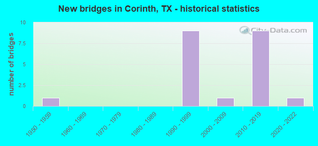
- New bridges - historical statistics
- 11950-1959
- 91990-1999
- 12000-2009
- 92010-2019
- 12020-2022

- Reconstructed bridges - Historical Statistics
- 11990-1999
- 02000-2009
- 12010-2019


- Bridge Condition - Superstructure
- 85.7%Very good
- 14.3%Good

- Bridge Condition - Substructure
- 28.6%Very good
- 71.4%Good

- Bridge Condition - Channel
- 22.2%Very good
- 44.4%Good
- 33.3%Satisfactory
Find on map >> Show street view
Structure Number: 180610019601257, Location: 0.95 MI NW OF FM 2181 (Lat: 33.140994, Lng: -97.050147), Route carried "on" structure: Interstate 35, Year Built: 1990, Status: Open, Structure Length: 7.53m (24.70ft), Average Daily Traffic: 47,631 (year 2019), Truck Traffic: 10%, Average Future Daily Traffic: 81,520 (year 2033), Design Load: HS 20, Features Intersected: FRONTAGE RD TURN AROUNDS
Minimum Vertical Clearance: 30+ m (98+ ft), Kilometerpoint: 20.806, Lanes on structure: 4, Lanes under structure: 2, Owner: State Highway Agency, Approaching Roadway Width: 18.0m (59.1ft), Material/Design: Prestressed concrete, Design/Construction: Stringer/Multi-beam, Number Of Spans In Main Unit: 3, Length of Maximum Span: 26.5m (86.9ft), Curb-To-Curb Width: 18.0m (59.1ft), Out-to-Out Width: 19.0m (62.3ft)
Condition: Deck: Good, Superstructure: Very good, Substructure: Good, Operating Rating: 54.4 metric tons, Method Used To Determine Operating Rating: Assigned rating based on Load Factor Design (LFD) reported in metric tons, Inventory Rating: 32.7 metric tons, Method Used To Determine Inventory Rating: Assigned rating based on Load Factor Design (LFD) reported in metric tons, Structural Evaluation: Better than present minimum criteria, Deck Geometry: Meets minimum limits, Underclear: High priority of corrective action, Approach Roadway Alignment: Equal to present desirable criteria, Length Of Structure Improvement: 7.53m (24.70ft), Designated Inspection Frequency: Every 24 months, Inspection Date: Febuary 2021, Deck Structure Type: Concrete Cast-file-Place, Wearing Surface/Protective System: Deck Protection: Epoxy Coated Reinforcing
Find on map >> Show street view
Structure Number: 180610019601258, Location: 0.95 MI NW OF FM 2181 (Lat: 33.140717, Lng: -97.050181), Route carried "on" structure: Interstate 35, Year Built: 1990, Status: Open, Structure Length: 7.53m (24.70ft), Average Daily Traffic: 46,823 (year 2019), Truck Traffic: 10%, Average Future Daily Traffic: 81,520 (year 2033), Design Load: HS 20, Features Intersected: FRONTAGE RD TURNAROUNDS
Minimum Vertical Clearance: 30+ m (98+ ft), Kilometerpoint: 20.806, Lanes on structure: 4, Lanes under structure: 2, Owner: State Highway Agency, Approaching Roadway Width: 18.0m (59.1ft), Material/Design: Prestressed concrete, Design/Construction: Stringer/Multi-beam, Number Of Spans In Main Unit: 3, Length of Maximum Span: 26.5m (86.9ft), Curb-To-Curb Width: 17.8m (58.4ft), Out-to-Out Width: 18.2m (59.7ft)
Condition: Deck: Good, Superstructure: Very good, Substructure: Good, Operating Rating: 54.4 metric tons, Method Used To Determine Operating Rating: Assigned rating based on Load Factor Design (LFD) reported in metric tons, Inventory Rating: 32.7 metric tons, Method Used To Determine Inventory Rating: Assigned rating based on Load Factor Design (LFD) reported in metric tons, Structural Evaluation: Better than present minimum criteria, Deck Geometry: Meets minimum limits, Underclear: High priority of corrective action, Approach Roadway Alignment: Equal to present desirable criteria, Length Of Structure Improvement: 7.53m (24.70ft), Designated Inspection Frequency: Every 24 months, Inspection Date: Febuary 2021, Deck Structure Type: Concrete Cast-file-Place, Wearing Surface/Protective System: Deck Protection: Epoxy Coated Reinforcing
Find on map >> Show street view
Structure Number: 180610019601259, Location: 7.55 MI NW OF SH 121 (Lat: 33.130206, Lng: -97.039550), Route carried "on" structure: Interstate 35, Year Built: 1990, Status: Open, Structure Length: 10.21m (33.50ft), Average Daily Traffic: 47,631 (year 2019), Truck Traffic: 9%, Average Future Daily Traffic: 75,180 (year 2033), Design Load: HS 20, Features Intersected: FM 2181
Minimum Vertical Clearance: 30+ m (98+ ft), Kilometerpoint: 19.222, Lanes on structure: 4, Lanes under structure: 8, Owner: State Highway Agency, Approaching Roadway Width: 17.7m (58.1ft), Skew: 4 degrees, Material/Design: Prestressed concrete, Design/Construction: Stringer/Multi-beam, Number Of Spans In Main Unit: 3, Length of Maximum Span: 38.1m (125.0ft), Curb-To-Curb Width: 17.8m (58.4ft), Out-to-Out Width: 19.0m (62.3ft)
Condition: Deck: Good, Superstructure: Good, Substructure: Good, Operating Rating: 54.4 metric tons, Method Used To Determine Operating Rating: Assigned rating based on Load Factor Design (LFD) reported in metric tons, Inventory Rating: 32.7 metric tons, Method Used To Determine Inventory Rating: Assigned rating based on Load Factor Design (LFD) reported in metric tons, Structural Evaluation: Better than present minimum criteria, Deck Geometry: Meets minimum limits, Underclear: Meets minimum limits, Approach Roadway Alignment: Equal to present desirable criteria, Length Of Structure Improvement: 10.21m (33.50ft), Designated Inspection Frequency: Every 24 months, Inspection Date: Febuary 2021, Deck Structure Type: Concrete Cast-file-Place, Wearing Surface/Protective System: Deck Protection: Epoxy Coated Reinforcing
Find on map >> Show street view
Structure Number: 18061001960126, Location: 7.55 MI NW OF SH 121 (Lat: 33.130081, Lng: -97.039728), Route carried "on" structure: Interstate 35, Year Built: 1990, Status: Open, Structure Length: 10.21m (33.50ft), Average Daily Traffic: 46,823 (year 2019), Truck Traffic: 9%, Average Future Daily Traffic: 75,180 (year 2033), Design Load: HS 20, Features Intersected: FM 2181
Minimum Vertical Clearance: 30+ m (98+ ft), Kilometerpoint: 19.222, Lanes on structure: 4, Lanes under structure: 8, Owner: State Highway Agency, Approaching Roadway Width: 17.7m (58.1ft), Skew: 4 degrees, Material/Design: Prestressed concrete, Design/Construction: Stringer/Multi-beam, Number Of Spans In Main Unit: 3, Length of Maximum Span: 38.1m (125.0ft), Curb-To-Curb Width: 17.9m (58.7ft), Out-to-Out Width: 18.2m (59.7ft)
Condition: Deck: Good, Superstructure: Very good, Substructure: Good, Operating Rating: 54.4 metric tons, Method Used To Determine Operating Rating: Assigned rating based on Load Factor Design (LFD) reported in metric tons, Inventory Rating: 32.7 metric tons, Method Used To Determine Inventory Rating: Assigned rating based on Load Factor Design (LFD) reported in metric tons, Structural Evaluation: Better than present minimum criteria, Deck Geometry: Meets minimum limits, Underclear: Meets minimum limits, Approach Roadway Alignment: Equal to present desirable criteria, Length Of Structure Improvement: 10.82m (35.50ft), Designated Inspection Frequency: Every 24 months, Inspection Date: Febuary 2021, Deck Structure Type: Concrete Cast-file-Place, Wearing Surface/Protective System: Deck Protection: Epoxy Coated Reinforcing
Find on map >> Show street view
Structure Number: 180610019601277, Location: 0.40 MI NW OF FM 2181 (Lat: 33.134522, Lng: -97.043958), Route carried "on" structure: Interstate 35, Year Built: 1950, Year Reconstructed: 1990, Status: Open, Structure Length: 1.49m (4.89ft), Average Daily Traffic: 86,898 (year 2020), Truck Traffic: 10%, Average Future Daily Traffic: 163,050 (year 2033), Design Load: H 15, Features Intersected: DRAINAGE DITCH
Minimum Vertical Clearance: 30+ m (98+ ft), Kilometerpoint: 19.895, Lanes on structure: 14, Owner: State Highway Agency, Approaching Roadway Width: 53.0m (173.9ft), Skew: 39 degrees, Material/Design: Concrete, Design/Construction: Culvert, Number Of Spans In Main Unit: 3, Length of Maximum Span: 3.0m (9.8ft)
Condition: Channel: Good, Culverts: Good, Operating Rating: 39.9 metric tons, Method Used To Determine Operating Rating: Load Factor (LF), Inventory Rating: 23.6 metric tons, Method Used To Determine Inventory Rating: Load Factor (LF), Structural Evaluation: Somewhat better than minimum adequacy, Waterway Adequacy: Equal to present minimum criteria, Approach Roadway Alignment: Equal to present desirable criteria, Designated Inspection Frequency: Every 24 months, Inspection Date: Febuary 2021
Find on map >> Show street view
Structure Number: 180610019601502, Location: 3.7 MI. SE. OF FM2181 (Lat: 33.151247, Lng: -97.060175), Route carried "on" structure: Interstate 35, Year Built: 2017, Status: Open, Structure Length: 10.39m (34.09ft), Average Daily Traffic: 61,060 (year 2020), Truck Traffic: 10%, Average Future Daily Traffic: 90,500 (year 2030), Design Load: HL 93, Features Intersected: CORINTH PARKWAY
Minimum Vertical Clearance: 30+ m (98+ ft), Kilometerpoint: 0.000, Lanes on structure: 8, Lanes under structure: 8, Owner: State Highway Agency, Maintenance Responsibility: Private, Approaching Roadway Width: 33.5m (109.9ft), Material/Design: Prestressed concrete, Design/Construction: Stringer/Multi-beam, Number Of Spans In Main Unit: 3, Length of Maximum Span: 36.9m (121.1ft), Curb-To-Curb Width: 16.8m (55.1ft), Out-to-Out Width: 35.4m (116.1ft)
Condition: Deck: Good, Superstructure: Very good, Substructure: Very good, Operating Rating: 54.4 metric tons, Method Used To Determine Operating Rating: Assigned ratings based on Load and Resistance Factor Design (LRFD) reported in metric tons, Inventory Rating: 32.7 metric tons, Method Used To Determine Inventory Rating: Assigned ratings based on Load and Resistance Factor Design (LRFD) reported in metric tons, Structural Evaluation: Equal to present desirable criteria, Deck Geometry: High priority of replacement, Underclear: Meets minimum limits, Approach Roadway Alignment: Equal to present desirable criteria, Designated Inspection Frequency: Every 24 months, Inspection Date: November 2021, Deck Structure Type: Concrete Precast Panels
Find on map >> Show street view
Structure Number: 180610019601514, Location: 2.6 MI SE OF LP 288 (Lat: 33.162414, Lng: -97.073253), Route carried "on" structure: City street , Year Built: 2017, Status: Open, Structure Length: 8.02m (26.31ft), Average Daily Traffic: 11,100 (year 2015), Truck Traffic: 3%, Average Future Daily Traffic: 15,540 (year 2037), Design Load: HL 93, Features Intersected: IH 35E, Facility Carried by Structure: POST OAK DR
Minimum Vertical Clearance: 30+ m (98+ ft), Kilometerpoint: 0.000, Lanes on structure: 8, Lanes under structure: 8, Owner: State Highway Agency, Maintenance Responsibility: Private, Approaching Roadway Width: 17.1m (56.1ft), Skew: 9 degrees, Material/Design: Prestressed concrete, Design/Construction: Stringer/Multi-beam, Number Of Spans In Main Unit: 2, Length of Maximum Span: 40.1m (131.6ft), Curb or Sidewalk Widths: Left: 2.6m (8.5ft), Right: 2.6m (8.5ft), Curb-To-Curb Width: 30.5m (100.1ft), Out-to-Out Width: 36.3m (119.1ft)
Condition: Deck: Good, Superstructure: Very good, Substructure: Good, Operating Rating: 54.4 metric tons, Method Used To Determine Operating Rating: Assigned ratings based on Load and Resistance Factor Design (LRFD) reported in metric tons, Inventory Rating: 32.7 metric tons, Method Used To Determine Inventory Rating: Assigned ratings based on Load and Resistance Factor Design (LRFD) reported in metric tons, Structural Evaluation: Better than present minimum criteria, Deck Geometry: Somewhat better than minimum adequacy, Underclear: High priority of corrective action, Approach Roadway Alignment: Equal to present desirable criteria, Designated Inspection Frequency: Every 24 months, Inspection Date: Febuary 2021, Deck Structure Type: Concrete Cast-file-Place, Wearing Surface/Protective System: Deck Protection: Epoxy Coated Reinforcing
Find on map >> Show street view
Structure Number: 180610205402263, Location: 1.6 MI W OF IH 35E (Lat: 33.129967, Lng: -97.069103), Route carried "on" structure: State highway 2181, Year Built: 2014, Year Reconstructed: 2015, Status: Open, Structure Length: 0.98m (3.22ft), Average Daily Traffic: 16,835 (year 2019), Truck Traffic: 4%, Average Future Daily Traffic: 20,202 (year 2039), Design Load: HL 93, Features Intersected: DRAW
Minimum Vertical Clearance: 30+ m (98+ ft), Kilometerpoint: 10.868, Lanes on structure: 7, Owner: State Highway Agency, Approaching Roadway Width: 25.6m (84.0ft), Skew: 31 degrees, Material/Design: Concrete, Design/Construction: Culvert, Number Of Spans In Main Unit: 4, Length of Maximum Span: 1.8m (5.9ft), Curb or Sidewalk Widths: Left: 1.5m (4.9ft), Right: 1.5m (4.9ft)
Condition: Channel: Satisfactory, Culverts: Good, Operating Rating: 54.4 metric tons, Method Used To Determine Operating Rating: Assigned ratings based on Load and Resistance Factor Design (LRFD) reported in metric tons, Inventory Rating: 32.7 metric tons, Method Used To Determine Inventory Rating: Assigned ratings based on Load and Resistance Factor Design (LRFD) reported in metric tons, Structural Evaluation: Better than present minimum criteria, Waterway Adequacy: Superior to present desirable criteria, Approach Roadway Alignment: Equal to present desirable criteria, Designated Inspection Frequency: Every 24 months, Inspection Date: January 2021
Find on map >> Show street view
Structure Number: 180610205402264, Location: 2.0 MI W OF IH 35E (Lat: 33.130931, Lng: -97.074206), Route carried "on" structure: State highway 2181, Year Built: 2014, Status: Open, Structure Length: 1.07m (3.51ft), Average Daily Traffic: 16,835 (year 2019), Truck Traffic: 4%, Average Future Daily Traffic: 20,202 (year 1939), Design Load: HL 93, Features Intersected: GRIFFITHS CREEK
Minimum Vertical Clearance: 30+ m (98+ ft), Kilometerpoint: 10.144, Lanes on structure: 7, Owner: State Highway Agency, Approaching Roadway Width: 25.6m (84.0ft), Skew: 31 degrees, Material/Design: Concrete, Design/Construction: Culvert, Number Of Spans In Main Unit: 4, Length of Maximum Span: 2.1m (6.9ft), Curb or Sidewalk Widths: Left: 1.5m (4.9ft), Right: 2.0m (6.6ft)
Condition: Channel: Good, Culverts: Good, Operating Rating: 54.4 metric tons, Method Used To Determine Operating Rating: Assigned ratings based on Load and Resistance Factor Design (LRFD) reported in metric tons, Inventory Rating: 54.4 metric tons, Method Used To Determine Inventory Rating: Assigned ratings based on Load and Resistance Factor Design (LRFD) reported in metric tons, Structural Evaluation: Better than present minimum criteria, Waterway Adequacy: Superior to present desirable criteria, Approach Roadway Alignment: Equal to present desirable criteria, Designated Inspection Frequency: Every 24 months, Inspection Date: January 2021
Find on map >> Show street view
Structure Number: 180610268101104, Location: 0.3 Mi N of FM 2181 (Lat: 33.137003, Lng: -97.095672), Route carried "on" structure: State highway 2499, Year Built: 2016, Status: Open, Structure Length: 1.16m (3.81ft), Average Daily Traffic: 16,500 (year 2020), Truck Traffic: 3%, Average Future Daily Traffic: 38,200 (year 2040), Design Load: HL 93, Features Intersected: Bryant Br Diversion
Minimum Vertical Clearance: 30+ m (98+ ft), Kilometerpoint: 0.483, Lanes on structure: 6, Owner: State Highway Agency, Approaching Roadway Width: 24.4m (80.1ft), Skew: 29 degrees, Material/Design: Concrete, Design/Construction: Culvert, Number Of Spans In Main Unit: 3, Length of Maximum Span: 3.0m (9.8ft), Curb or Sidewalk Widths: Left: 2.0m (6.6ft), Right: 2.2m (7.2ft)
Condition: Channel: Good, Culverts: Good, Operating Rating: 54.4 metric tons, Method Used To Determine Operating Rating: Assigned ratings based on Load and Resistance Factor Design (LRFD) reported in metric tons, Inventory Rating: 32.7 metric tons, Method Used To Determine Inventory Rating: Assigned ratings based on Load and Resistance Factor Design (LRFD) reported in metric tons, Structural Evaluation: Better than present minimum criteria, Waterway Adequacy: Superior to present desirable criteria, Approach Roadway Alignment: Equal to present desirable criteria, Designated Inspection Frequency: Every 24 months, Inspection Date: August 2020
Find on map >> Show street view
Structure Number: 180610268101111, Location: 0.2 MI N OF FM 2181 (Lat: 33.135500, Lng: -97.094489), Route carried "on" structure: State highway , Year Built: 2016, Status: Open, Structure Length: 13.41m (44.00ft), Average Daily Traffic: 28,000 (year 2019), Truck Traffic: 3%, Average Future Daily Traffic: 43,600 (year 2039), Design Load: HL 93, Features Intersected: Bryant Branch, Facility Carried by Structure: FM 2499 (Barrel)
Minimum Vertical Clearance: 30+ m (98+ ft), Kilometerpoint: 0.322, Lanes on structure: 6, Owner: State Highway Agency, Approaching Roadway Width: 24.4m (80.1ft), Skew: 10 degrees, Material/Design: Prestressed concrete, Design/Construction: Stringer/Multi-beam, Number Of Spans In Main Unit: 4, Length of Maximum Span: 33.5m (109.9ft), Curb or Sidewalk Widths: Left: 2.0m (6.6ft), Right: 1.9m (6.2ft), Curb-To-Curb Width: 24.5m (80.4ft), Out-to-Out Width: 33.8m (110.9ft)
Condition: Deck: Good, Superstructure: Very good, Substructure: Very good, Channel: Very good, Operating Rating: 54.4 metric tons, Method Used To Determine Operating Rating: Assigned ratings based on Load and Resistance Factor Design (LRFD) reported in metric tons, Inventory Rating: 32.7 metric tons, Method Used To Determine Inventory Rating: Assigned ratings based on Load and Resistance Factor Design (LRFD) reported in metric tons, Structural Evaluation: Equal to present desirable criteria, Deck Geometry: Somewhat better than minimum adequacy, Waterway Adequacy: Superior to present desirable criteria, Approach Roadway Alignment: Equal to present desirable criteria, Designated Inspection Frequency: Every 24 months, Inspection Date: August 2020, Deck Structure Type: Concrete Precast Panels
Find on map >> Show street view
Structure Number: 180610LR6350005, Location: 0.2 MI S of Old Justin Rd (Lat: 33.115950, Lng: -97.248031), Route carried "on" structure: City street , Year Built: 2016, Status: Open, Structure Length: 0.67m (2.20ft), Average Daily Traffic: 200 (year 2020), Average Future Daily Traffic: 250 (year 2040), Features Intersected: DRAW, Facility Carried by Structure: FLANAGAN FARM DR
Minimum Vertical Clearance: 30+ m (98+ ft), Kilometerpoint: 0.341, Lanes on structure: 2, Owner: Town or Township Highway Agency, Approaching Roadway Width: 7.3m (24.0ft), Material/Design: Concrete, Design/Construction: Culvert, Number Of Spans In Main Unit: 2, Length of Maximum Span: 3.0m (9.8ft), Curb-To-Curb Width: 10.1m (33.1ft), Out-to-Out Width: 13.4m (44.0ft)
Condition: Channel: Satisfactory, Culverts: Good, Operating Rating: 24.5 metric tons, Method Used To Determine Operating Rating: Field evaluation and documented engineering judgment, Inventory Rating: 18.1 metric tons, Method Used To Determine Inventory Rating: Field evaluation and documented engineering judgment, Structural Evaluation: Somewhat better than minimum adequacy, Deck Geometry: Better than present minimum criteria, Waterway Adequacy: Superior to present desirable criteria, Approach Roadway Alignment: Equal to present desirable criteria, Designated Inspection Frequency: Every 24 months, Inspection Date: January 2021, Deck Structure Type: Concrete Cast-file-Place, Wearing Surface/Protective System: Wearing Surface: Monolithic Concrete
Find on map >> Show street view
Structure Number: 180610N00056001, Location: 1.15 MI E OF IH 35E NBFR (Lat: 33.150300, Lng: -97.042497), Route carried "on" structure: City street , Year Built: 2001, Status: Open, Structure Length: 1.25m (4.10ft), Average Daily Traffic: 600 (year 2010), Average Future Daily Traffic: 700 (year 2027), Features Intersected: GRAVEYARD SLOUGH, Facility Carried by Structure: CORINTH PKWY
Minimum Vertical Clearance: 30+ m (98+ ft), Kilometerpoint: 1.609, Lanes on structure: 4, Owner: City or Municipal Highway Agency, Approaching Roadway Width: 14.6m (47.9ft), Skew: 21 degrees, Material/Design: Concrete, Design/Construction: Culvert, Number Of Spans In Main Unit: 4, Length of Maximum Span: 2.7m (8.9ft), Curb or Sidewalk Widths: Left: 2.9m (9.5ft), Right: 3.6m (11.8ft), Curb-To-Curb Width: 14.6m (47.9ft), Out-to-Out Width: 26.6m (87.3ft)
Condition: Channel: Satisfactory, Culverts: Good, Operating Rating: 32.7 metric tons, Method Used To Determine Operating Rating: Field evaluation and documented engineering judgment, Inventory Rating: 24.5 metric tons, Method Used To Determine Inventory Rating: Field evaluation and documented engineering judgment, Structural Evaluation: Equal to present minimum criteria, Deck Geometry: High priority of replacement, Waterway Adequacy: Equal to present minimum criteria, Approach Roadway Alignment: Equal to present desirable criteria, Length Of Structure Improvement: 1.25m (4.10ft), Designated Inspection Frequency: Every 24 months, Inspection Date: December 2020, Bridge Improvement Cost: $4,000, Roadway Improvement Cost: $1,000, Total Project Cost: $5,000, Deck Structure Type: Concrete Cast-file-Place, Wearing Surface/Protective System: Wearing Surface: Monolithic Concrete
Find on map >> Show street view
Structure Number: 180610N00125005, Location: 0.15 MI E of FM 2499 (Lat: 33.143022, Lng: -97.093419), Route carried "on" structure: City street , Year Built: 2020, Status: Open, Structure Length: 2.23m (7.32ft), Average Daily Traffic: 4,364 (year 2019), Truck Traffic: 3%, Average Future Daily Traffic: 6,110 (year 2039), Design Load: HL 93, Features Intersected: BRYANT BRANCH, Facility Carried by Structure: LAKE SHARON DR
Minimum Vertical Clearance: 30+ m (98+ ft), Kilometerpoint: 0.245, Lanes on structure: 4, Owner: City or Municipal Highway Agency, Approaching Roadway Width: 14.6m (47.9ft), Skew: 30 degrees, Material/Design: Concrete, Design/Construction: Culvert, Number Of Spans In Main Unit: 6, Length of Maximum Span: 3.0m (9.8ft), Curb or Sidewalk Widths: Left: 1.5m (4.9ft), Right: 1.5m (4.9ft), Curb-To-Curb Width: 14.6m (47.9ft), Out-to-Out Width: 25.6m (84.0ft)
Condition: Channel: Very good, Culverts: Good, Operating Rating: 54.4 metric tons, Method Used To Determine Operating Rating: Assigned ratings based on Load and Resistance Factor Design (LRFD) reported in metric tons, Inventory Rating: 32.7 metric tons, Method Used To Determine Inventory Rating: Assigned ratings based on Load and Resistance Factor Design (LRFD) reported in metric tons, Structural Evaluation: Better than present minimum criteria, Deck Geometry: High priority of replacement, Waterway Adequacy: Superior to present desirable criteria, Approach Roadway Alignment: Equal to present desirable criteria, Designated Inspection Frequency: Every 24 months, Inspection Date: January 2021, Deck Structure Type: Concrete Precast Panels, Wearing Surface/Protective System: Wearing Surface: Monolithic Concrete
Find on map >> Show street view
Structure Number: 180610N00187001, Location: 0.15 MI N OF FM 2181 (Lat: 33.131658, Lng: -97.073569), Route carried "on" structure: City street , Year Built: 1999, Status: Open, Structure Length: 0.91m (2.99ft), Average Daily Traffic: 300 (year 2017), Average Future Daily Traffic: 300 (year 2037), Features Intersected: DRAIN, Facility Carried by Structure: REGINA DR
Minimum Vertical Clearance: 30+ m (98+ ft), Kilometerpoint: 0.241, Lanes on structure: 2, Owner: City or Municipal Highway Agency, Approaching Roadway Width: 9.1m (29.9ft), Material/Design: Concrete, Design/Construction: Culvert, Number Of Spans In Main Unit: 3, Length of Maximum Span: 2.4m (7.9ft), Curb or Sidewalk Widths: Left: 1.0m (3.3ft), Right: 1.1m (3.6ft), Curb-To-Curb Width: 11.0m (36.1ft), Out-to-Out Width: 15.8m (51.8ft)
Condition: Channel: Good, Culverts: Good, Operating Rating: 32.7 metric tons, Method Used To Determine Operating Rating: Field evaluation and documented engineering judgment, Inventory Rating: 24.5 metric tons, Method Used To Determine Inventory Rating: Field evaluation and documented engineering judgment, Structural Evaluation: Equal to present minimum criteria, Deck Geometry: Equal to present desirable criteria, Waterway Adequacy: Better than present minimum criteria, Approach Roadway Alignment: Equal to present desirable criteria, Designated Inspection Frequency: Every 24 months, Inspection Date: December 2020
Find on map >> Show street view
Structure Number: 180610019601257, Location: 0.95 MI NW OF FM 2181 (Lat: 33.140994, Lng: -97.050147), Route carried "under" structure: ServiceOther road 35, Year Built: 1990, Structure Length: 0. m, Average Daily Traffic: 11,000 (year 2016), Truck Traffic: 9%, Features Intersected: None
Minimum Vertical Clearance: 5.72m (18.77ft), Kilometerpoint: 20.761, Lanes on structure: 4, Lanes under structure: 2, Material/Design: Prestressed concrete, Design/Construction: Stringer/Multi-beam, Length of Maximum Span: 26.5m (86.9ft)
Find on map >> Show street view
Structure Number: 180610019601258, Location: 0.95 MI NW OF FM 2181 (Lat: 33.140717, Lng: -97.050181), Route carried "under" structure: ServiceOther road 35, Year Built: 1990, Structure Length: 0. m, Average Daily Traffic: 11,000 (year 2008), Truck Traffic: 9%, Features Intersected: None
Minimum Vertical Clearance: 5.33m (17.49ft), Kilometerpoint: 20.806, Lanes on structure: 4, Lanes under structure: 2, Material/Design: Prestressed concrete, Design/Construction: Stringer/Multi-beam, Length of Maximum Span: 26.5m (86.9ft)
Find on map >> Show street view
Structure Number: 180610019601259, Location: 7.55 MI NW OF SH 121 (Lat: 33.130206, Lng: -97.039550), Route carried "under" structure: State highway 2181, Year Built: 1990, Structure Length: 0. m, Average Daily Traffic: 15,100 (year 2011), Truck Traffic: 6%, Features Intersected: FM 2181, Facility Carried by Structure: IH 35E NBML
Minimum Vertical Clearance: 6.20m (20.34ft), Kilometerpoint: 14.354, Lanes on structure: 4, Lanes under structure: 8, Material/Design: Prestressed concrete, Design/Construction: Stringer/Multi-beam, Length of Maximum Span: 38.1m (125.0ft)
Find on map >> Show street view
Structure Number: 18061001960126, Location: 7.55 MI NW OF SH 121 (Lat: 33.130081, Lng: -97.039728), Route carried "under" structure: State highway 2181, Year Built: 1990, Structure Length: 0. m, Average Daily Traffic: 15,100 (year 2011), Truck Traffic: 6%, Features Intersected: FM 2181, Facility Carried by Structure: IH 35E SBML
Minimum Vertical Clearance: 5.18m (16.99ft), Kilometerpoint: 14.354, Lanes on structure: 4, Lanes under structure: 8, Material/Design: Prestressed concrete, Design/Construction: Stringer/Multi-beam, Length of Maximum Span: 38.1m (125.0ft)
Find on map >> Show street view
Structure Number: 180610019601502, Location: 3.7 MI. SE. OF FM2181 (Lat: 33.151200, Lng: -97.060200), Route carried "under" structure: City street , Year Built: 2017, Structure Length: 0. m, Average Daily Traffic: 62,000 (year 2010), Truck Traffic: 10%, Features Intersected: CORINTH PARKWAY, Facility Carried by Structure: IH-35E
Minimum Vertical Clearance: 30+ m (98+ ft), Kilometerpoint: 0.000, Lanes on structure: 6, Material/Design: Prestressed concrete, Design/Construction: Stringer/Multi-beam, Length of Maximum Span: 36.9m (121.1ft)
Find on map >> Show street view
Structure Number: 180610019601514, Location: 2.6 MI SE OF LP 288 (Lat: 33.162414, Lng: -97.073253), Route carried "under" structure: Interstate 35, Year Built: 2017, Structure Length: 0. m, Average Daily Traffic: 77,462 (year 2017), Truck Traffic: 11%, Features Intersected: POST OAK RD, Facility Carried by Structure: POST OAK DR
Minimum Vertical Clearance: 5.97m (19.59ft), Kilometerpoint: 0.000, Lanes on structure: 8, Lanes under structure: 8, Material/Design: Prestressed concrete, Design/Construction: Stringer/Multi-beam, Length of Maximum Span: 40.1m (131.6ft)