Bridge Statistics for Coachella, California (CA)
Condition, Traffic, Stress, Structural Evaluation, Project Costs
- National Bridge Inventory (NBI) Statistics
- 27Number of bridges
- 410ft / 125mTotal length
- $5,542,000Total costs
- 362,709Total average daily traffic
- 89,196Total average daily truck traffic
- National Bridge Inventory (NBI) Registered Bridges for Coachella
- No street view available for this location
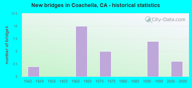
- New bridges - historical statistics
- 21940-1949
- 101960-1969
- 51970-1979
- 71990-1999
- 32000-2009


- Bridge Condition - Deck
- 50.0%Good
- 40.9%Fair
- 9.1%Poor

- Bridge Condition - Superstructure
- 81.8%Good
- 18.2%Fair

- Bridge Condition - Substructure
- 90.9%Good
- 9.1%Fair

- Bridge Condition - Channel
- 22.2%Excellent
- 44.4%Very good
- 11.1%Good
- 22.2%Fair
Find on map >> Show street view
Structure Number: 56 0079L, Location: 08-RIV-010-R60.39-COA (Lat: 33.709264, Lng: -116.148269), Route carried "on" structure: Interstate 10, Year Built: 1972, Status: Open, Structure Length: 2.62m (8.60ft), Average Daily Traffic: 11,250 (year 2014), Truck Traffic: 39%, Average Future Daily Traffic: 19,077 (year 2040), Design Load: HS 20, Features Intersected: COACHELLA CANAL
Minimum Vertical Clearance: 30+ m (98+ ft), Kilometerpoint: 60.390, Lanes on structure: 2, Base Highway Network: Yes (, Subroute: 1), Owner: State Highway Agency, Approaching Roadway Width: 11.9m (39.0ft), Skew: 4 degrees, Material/Design: Prestressed concrete, Design/Construction: Stringer/Multi-beam, Number Of Spans In Main Unit: 1, Length of Maximum Span: 25.6m (84.0ft), Curb-To-Curb Width: 11.9m (39.0ft), Out-to-Out Width: 12.5m (41.0ft)
Condition: Deck: Good, Superstructure: Good, Substructure: Good, Channel: Excellent, Operating Rating: 53.8 metric tons, Method Used To Determine Operating Rating: Load and Resistance Factor Rating (LRFR) rating reported by rating factor(RF) method using HL-93 loadings, Inventory Rating: 27.2 metric tons, Method Used To Determine Inventory Rating: Load and Resistance Factor Rating (LRFR) rating reported by rating factor(RF) method using HL-93 loadings, Structural Evaluation: Equal to present minimum criteria, Deck Geometry: Equal to present minimum criteria, Waterway Adequacy: Superior to present desirable criteria, Approach Roadway Alignment: Equal to present desirable criteria, Designated Inspection Frequency: Every 24 months, Inspection Date: October 2021, Deck Structure Type: Concrete Cast-file-Place
Find on map >> Show street view
Structure Number: 56 0079R, Location: 08-RIV-010-R60.40-COA (Lat: 33.708944, Lng: -116.148175), Route carried "on" structure: Interstate 10, Year Built: 1947, Status: Open, Structure Length: 2.38m (7.81ft), Average Daily Traffic: 11,250 (year 2014), Truck Traffic: 39%, Average Future Daily Traffic: 19,077 (year 2040), Design Load: HS 20, Features Intersected: COACHELLA CANAL
Minimum Vertical Clearance: 30+ m (98+ ft), Kilometerpoint: 60.400, Lanes on structure: 2, Base Highway Network: Yes (, Subroute: 1), Owner: State Highway Agency, Approaching Roadway Width: 11.9m (39.0ft), Skew: 2 degrees, Material/Design: Concrete continuous, Design/Construction: Slab, Number Of Spans In Main Unit: 4, Length of Maximum Span: 9.8m (32.2ft), Curb-To-Curb Width: 11.9m (39.0ft), Out-to-Out Width: 12.5m (41.0ft)
Condition: Deck: Poor, Superstructure: Fair, Substructure: Good, Channel: Excellent, Operating Rating: 63.5 metric tons, Method Used To Determine Operating Rating: Load Factor (LF), Inventory Rating: 38.2 metric tons, Method Used To Determine Inventory Rating: Load Factor (LF), Structural Evaluation: Somewhat better than minimum adequacy, Deck Geometry: Equal to present minimum criteria, Waterway Adequacy: Superior to present desirable criteria, Approach Roadway Alignment: Equal to present desirable criteria, Length Of Structure Improvement: 3.23m (10.60ft), Designated Inspection Frequency: Every 24 months, Inspection Date: October 2021, Deck Structure Type: Concrete Cast-file-Place
Find on map >> Show street view
Structure Number: 56 0201L, Location: 08-RIV-010-R63.65-COA (Lat: 33.699050, Lng: -116.105908), Route carried "on" structure: Interstate 10, Year Built: 1964, Status: Open, Structure Length: 5.97m (19.59ft), Average Daily Traffic: 11,250 (year 2012), Truck Traffic: 39%, Average Future Daily Traffic: 19,077 (year 2040), Design Load: HS 20, Features Intersected: SMOKY GULCH
Minimum Vertical Clearance: 30+ m (98+ ft), Kilometerpoint: 63.650, Lanes on structure: 2, Base Highway Network: Yes (, Subroute: 1), Owner: State Highway Agency, Approaching Roadway Width: 11.9m (39.0ft), Skew: 2 degrees, Material/Design: Concrete continuous, Design/Construction: Tee Beam, Number Of Spans In Main Unit: 4, Length of Maximum Span: 16.8m (55.1ft), Curb-To-Curb Width: 11.9m (39.0ft), Out-to-Out Width: 12.7m (41.7ft)
Condition: Deck: Good, Superstructure: Good, Substructure: Good, Channel: Fair, Operating Rating: 36.3 metric tons, Method Used To Determine Operating Rating: Load and Resistance Factor Rating (LRFR) rating reported by rating factor(RF) method using HL-93 loadings, Inventory Rating: 28.2 metric tons, Method Used To Determine Inventory Rating: Load and Resistance Factor Rating (LRFR) rating reported by rating factor(RF) method using HL-93 loadings, Structural Evaluation: Better than present minimum criteria, Deck Geometry: Equal to present minimum criteria, Waterway Adequacy: Equal to present desirable criteria, Approach Roadway Alignment: Equal to present desirable criteria, Designated Inspection Frequency: Every 24 months, Inspection Date: October 2020, Deck Structure Type: Concrete Cast-file-Place
Find on map >> Show street view
Structure Number: 56 0201R, Location: 08-RIV-010-R63.65-COA (Lat: 33.698533, Lng: -116.106447), Route carried "on" structure: Interstate 10, Year Built: 1964, Status: Open, Structure Length: 7.19m (23.59ft), Average Daily Traffic: 11,250 (year 2012), Truck Traffic: 39%, Average Future Daily Traffic: 19,077 (year 2040), Design Load: HS 20, Features Intersected: SMOKY GULCH
Minimum Vertical Clearance: 30+ m (98+ ft), Kilometerpoint: 63.650, Lanes on structure: 2, Base Highway Network: Yes (, Subroute: 1), Owner: State Highway Agency, Approaching Roadway Width: 11.9m (39.0ft), Skew: 2 degrees, Material/Design: Concrete continuous, Design/Construction: Tee Beam, Number Of Spans In Main Unit: 4, Length of Maximum Span: 20.1m (65.9ft), Curb-To-Curb Width: 11.9m (39.0ft), Out-to-Out Width: 12.7m (41.7ft)
Condition: Deck: Good, Superstructure: Good, Substructure: Good, Channel: Fair, Operating Rating: 41.8 metric tons, Method Used To Determine Operating Rating: Load and Resistance Factor Rating (LRFR) rating reported by rating factor(RF) method using HL-93 loadings, Inventory Rating: 32.1 metric tons, Method Used To Determine Inventory Rating: Load and Resistance Factor Rating (LRFR) rating reported by rating factor(RF) method using HL-93 loadings, Structural Evaluation: Better than present minimum criteria, Deck Geometry: Equal to present minimum criteria, Waterway Adequacy: Equal to present desirable criteria, Approach Roadway Alignment: Equal to present desirable criteria, Designated Inspection Frequency: Every 24 months, Inspection Date: October 2020, Deck Structure Type: Concrete Cast-file-Place
Find on map >> Show street view
Structure Number: 56 0202L, Location: 08-RIV-010-R66.18 (Lat: 33.698567, Lng: -116.062308), Route carried "on" structure: Interstate 10, Year Built: 1964, Status: Open, Structure Length: 4.33m (14.21ft), Average Daily Traffic: 11,250 (year 2012), Truck Traffic: 39%, Average Future Daily Traffic: 19,077 (year 2040), Design Load: HS 20, Features Intersected: SUNNY GULCH
Minimum Vertical Clearance: 30+ m (98+ ft), Kilometerpoint: 66.180, Lanes on structure: 2, Base Highway Network: Yes (, Subroute: 1), Owner: State Highway Agency, Approaching Roadway Width: 11.9m (39.0ft), Skew: 3 degrees, Material/Design: Concrete continuous, Design/Construction: Tee Beam, Number Of Spans In Main Unit: 3, Length of Maximum Span: 16.8m (55.1ft), Curb-To-Curb Width: 11.9m (39.0ft), Out-to-Out Width: 12.7m (41.7ft)
Condition: Deck: Good, Superstructure: Good, Substructure: Good, Channel: Fair, Operating Rating: 49.6 metric tons, Method Used To Determine Operating Rating: Load and Resistance Factor Rating (LRFR) rating reported by rating factor(RF) method using HL-93 loadings, Inventory Rating: 38.2 metric tons, Method Used To Determine Inventory Rating: Load and Resistance Factor Rating (LRFR) rating reported by rating factor(RF) method using HL-93 loadings, Structural Evaluation: Better than present minimum criteria, Deck Geometry: Equal to present minimum criteria, Waterway Adequacy: Equal to present desirable criteria, Approach Roadway Alignment: Equal to present desirable criteria, Designated Inspection Frequency: Every 24 months, Inspection Date: October 2020, Deck Structure Type: Concrete Cast-file-Place
Find on map >> Show street view
Structure Number: 56 0202R, Location: 08-RIV-010-R66.18 (Lat: 33.698217, Lng: -116.063147), Route carried "on" structure: Interstate 10, Year Built: 1964, Status: Open, Structure Length: 4.63m (15.19ft), Average Daily Traffic: 11,250 (year 2012), Truck Traffic: 39%, Average Future Daily Traffic: 19,077 (year 2040), Design Load: HS 20, Features Intersected: SUNNY GULCH
Minimum Vertical Clearance: 30+ m (98+ ft), Kilometerpoint: 66.180, Lanes on structure: 2, Base Highway Network: Yes (, Subroute: 1), Owner: State Highway Agency, Approaching Roadway Width: 11.9m (39.0ft), Skew: 3 degrees, Material/Design: Concrete continuous, Design/Construction: Tee Beam, Number Of Spans In Main Unit: 3, Length of Maximum Span: 18.0m (59.1ft), Curb-To-Curb Width: 11.9m (39.0ft), Out-to-Out Width: 12.7m (41.7ft)
Condition: Deck: Good, Superstructure: Good, Substructure: Good, Channel: Fair, Operating Rating: 46.7 metric tons, Method Used To Determine Operating Rating: Load and Resistance Factor Rating (LRFR) rating reported by rating factor(RF) method using HL-93 loadings, Inventory Rating: 36.0 metric tons, Method Used To Determine Inventory Rating: Load and Resistance Factor Rating (LRFR) rating reported by rating factor(RF) method using HL-93 loadings, Structural Evaluation: Better than present minimum criteria, Deck Geometry: Equal to present minimum criteria, Waterway Adequacy: Equal to present desirable criteria, Approach Roadway Alignment: Equal to present desirable criteria, Designated Inspection Frequency: Every 24 months, Inspection Date: October 2020, Deck Structure Type: Concrete Cast-file-Place
Find on map >> Show street view
Structure Number: 56 0204L, Location: 08-RIV-010-R68.29 (Lat: 33.687039, Lng: -116.028944), Route carried "on" structure: Interstate 10, Year Built: 1964, Status: Open, Structure Length: 5.09m (16.70ft), Average Daily Traffic: 11,250 (year 2012), Truck Traffic: 39%, Average Future Daily Traffic: 19,077 (year 2040), Design Load: HS 20, Features Intersected: BROWN ARROYO
Minimum Vertical Clearance: 30+ m (98+ ft), Kilometerpoint: 68.290, Lanes on structure: 2, Base Highway Network: Yes (, Subroute: 1), Owner: State Highway Agency, Approaching Roadway Width: 11.9m (39.0ft), Skew: 1 degrees, Material/Design: Concrete continuous, Design/Construction: Tee Beam, Number Of Spans In Main Unit: 3, Length of Maximum Span: 25.0m (82.0ft), Curb-To-Curb Width: 11.9m (39.0ft), Out-to-Out Width: 12.7m (41.7ft)
Condition: Deck: Good, Superstructure: Good, Substructure: Good, Channel: Very good, Operating Rating: 42.4 metric tons, Method Used To Determine Operating Rating: Load and Resistance Factor Rating (LRFR) rating reported by rating factor(RF) method using HL-93 loadings, Inventory Rating: 32.7 metric tons, Method Used To Determine Inventory Rating: Load and Resistance Factor Rating (LRFR) rating reported by rating factor(RF) method using HL-93 loadings, Structural Evaluation: Better than present minimum criteria, Deck Geometry: Equal to present minimum criteria, Waterway Adequacy: Equal to present desirable criteria, Approach Roadway Alignment: Equal to present desirable criteria, Designated Inspection Frequency: Every 24 months, Inspection Date: October 2020, Deck Structure Type: Concrete Cast-file-Place
Find on map >> Show street view
Structure Number: 56 0204R, Location: 08-RIV-010-R68.29 (Lat: 33.686528, Lng: -116.029411), Route carried "on" structure: Interstate 10, Year Built: 1964, Status: Open, Structure Length: 7.19m (23.59ft), Average Daily Traffic: 11,250 (year 2012), Truck Traffic: 39%, Average Future Daily Traffic: 19,077 (year 2040), Design Load: HS 20, Features Intersected: BROWN ARROYO
Minimum Vertical Clearance: 30+ m (98+ ft), Kilometerpoint: 68.290, Lanes on structure: 2, Base Highway Network: Yes (, Subroute: 1), Owner: State Highway Agency, Approaching Roadway Width: 11.9m (39.0ft), Skew: 1 degrees, Material/Design: Concrete continuous, Design/Construction: Tee Beam, Number Of Spans In Main Unit: 4, Length of Maximum Span: 20.1m (65.9ft), Curb-To-Curb Width: 11.9m (39.0ft), Out-to-Out Width: 12.7m (41.7ft)
Condition: Deck: Good, Superstructure: Good, Substructure: Good, Channel: Very good, Operating Rating: 41.8 metric tons, Method Used To Determine Operating Rating: Load and Resistance Factor Rating (LRFR) rating reported by rating factor(RF) method using HL-93 loadings, Inventory Rating: 32.4 metric tons, Method Used To Determine Inventory Rating: Load and Resistance Factor Rating (LRFR) rating reported by rating factor(RF) method using HL-93 loadings, Structural Evaluation: Better than present minimum criteria, Deck Geometry: Equal to present minimum criteria, Waterway Adequacy: Equal to present desirable criteria, Approach Roadway Alignment: Equal to present desirable criteria, Designated Inspection Frequency: Every 24 months, Inspection Date: October 2020, Deck Structure Type: Concrete Cast-file-Place
Find on map >> Show street view
Structure Number: 56 0475L, Location: 08-RIV-010-R62.62-COA (Lat: 33.702381, Lng: -116.123486), Route carried "on" structure: Interstate 10, Year Built: 1964, Status: Open, Structure Length: 2.07m (6.79ft), Average Daily Traffic: 11,250 (year 2012), Truck Traffic: 39%, Average Future Daily Traffic: 19,077 (year 2040), Design Load: HS 20, Features Intersected: ECHO DITCH
Minimum Vertical Clearance: 30+ m (98+ ft), Kilometerpoint: 62.620, Lanes on structure: 2, Base Highway Network: Yes (, Subroute: 1), Owner: State Highway Agency, Approaching Roadway Width: 11.9m (39.0ft), Material/Design: Concrete continuous, Design/Construction: Slab, Number Of Spans In Main Unit: 3, Length of Maximum Span: 6.7m (22.0ft), Curb-To-Curb Width: 11.9m (39.0ft), Out-to-Out Width: 12.7m (41.7ft)
Condition: Deck: Good, Superstructure: Good, Substructure: Good, Channel: Very good, Operating Rating: 57.0 metric tons, Method Used To Determine Operating Rating: Load Factor (LF), Inventory Rating: 34.3 metric tons, Method Used To Determine Inventory Rating: Load Factor (LF), Structural Evaluation: Better than present minimum criteria, Deck Geometry: Equal to present minimum criteria, Waterway Adequacy: Equal to present desirable criteria, Approach Roadway Alignment: Equal to present desirable criteria, Designated Inspection Frequency: Every 24 months, Inspection Date: October 2020, Deck Structure Type: Concrete Cast-file-Place
Find on map >> Show street view
Structure Number: 56 0475R, Location: 08-RIV-010-R62.62-COA (Lat: 33.701792, Lng: -116.123647), Route carried "on" structure: Interstate 10, Year Built: 1964, Status: Open, Structure Length: 2.07m (6.79ft), Average Daily Traffic: 11,250 (year 2012), Truck Traffic: 39%, Average Future Daily Traffic: 19,077 (year 2040), Design Load: HS 20, Features Intersected: ECHO DITCH
Minimum Vertical Clearance: 30+ m (98+ ft), Kilometerpoint: 62.620, Lanes on structure: 2, Base Highway Network: Yes (, Subroute: 1), Owner: State Highway Agency, Approaching Roadway Width: 11.9m (39.0ft), Material/Design: Concrete continuous, Design/Construction: Slab, Number Of Spans In Main Unit: 3, Length of Maximum Span: 6.7m (22.0ft), Curb-To-Curb Width: 11.9m (39.0ft), Out-to-Out Width: 12.7m (41.7ft)
Condition: Deck: Good, Superstructure: Good, Substructure: Good, Channel: Very good, Operating Rating: 57.0 metric tons, Method Used To Determine Operating Rating: Load Factor (LF), Inventory Rating: 34.3 metric tons, Method Used To Determine Inventory Rating: Load Factor (LF), Structural Evaluation: Better than present minimum criteria, Deck Geometry: Equal to present minimum criteria, Waterway Adequacy: Equal to present desirable criteria, Approach Roadway Alignment: Equal to present desirable criteria, Designated Inspection Frequency: Every 24 months, Inspection Date: October 2020, Deck Structure Type: Concrete Cast-file-Place
Find on map >> Show street view
Structure Number: 56 0476L, Location: 08-RIV-010-R62.03-COA (Lat: 33.705006, Lng: -116.133269), Route carried "on" structure: Interstate 10, Year Built: 1964, Status: Open, Structure Length: 1.89m (6.20ft), Average Daily Traffic: 11,250 (year 2014), Truck Traffic: 39%, Average Future Daily Traffic: 19,077 (year 2040), Design Load: HS 20, Features Intersected: POLARIS WASH
Minimum Vertical Clearance: 30+ m (98+ ft), Kilometerpoint: 62.030, Lanes on structure: 2, Base Highway Network: Yes (, Subroute: 1), Owner: State Highway Agency, Approaching Roadway Width: 11.9m (39.0ft), Skew: 1 degrees, Material/Design: Concrete continuous, Design/Construction: Slab, Number Of Spans In Main Unit: 3, Length of Maximum Span: 6.1m (20.0ft), Curb-To-Curb Width: 11.9m (39.0ft), Out-to-Out Width: 12.7m (41.7ft)
Condition: Deck: Good, Superstructure: Good, Substructure: Good, Channel: Very good, Operating Rating: 52.8 metric tons, Method Used To Determine Operating Rating: Load Factor (LF), Inventory Rating: 31.8 metric tons, Method Used To Determine Inventory Rating: Load Factor (LF), Structural Evaluation: Better than present minimum criteria, Deck Geometry: Equal to present minimum criteria, Waterway Adequacy: Equal to present desirable criteria, Approach Roadway Alignment: Equal to present desirable criteria, Designated Inspection Frequency: Every 24 months, Inspection Date: October 2021, Deck Structure Type: Concrete Cast-file-Place
Find on map >> Show street view
Structure Number: 56 0476R, Location: 08-RIV-010-R62.03-COA (Lat: 33.704403, Lng: -116.133364), Route carried "on" structure: Interstate 10, Year Built: 1964, Status: Open, Structure Length: 1.89m (6.20ft), Average Daily Traffic: 11,250 (year 2014), Truck Traffic: 39%, Average Future Daily Traffic: 19,077 (year 2040), Design Load: HS 20, Features Intersected: POLARIS WASH
Minimum Vertical Clearance: 30+ m (98+ ft), Kilometerpoint: 62.030, Lanes on structure: 2, Base Highway Network: Yes (, Subroute: 1), Owner: State Highway Agency, Approaching Roadway Width: 11.9m (39.0ft), Skew: 1 degrees, Material/Design: Concrete continuous, Design/Construction: Slab, Number Of Spans In Main Unit: 3, Length of Maximum Span: 6.4m (21.0ft), Curb-To-Curb Width: 11.9m (39.0ft), Out-to-Out Width: 12.7m (41.7ft)
Condition: Deck: Fair, Superstructure: Fair, Substructure: Good, Channel: Very good, Operating Rating: 52.8 metric tons, Method Used To Determine Operating Rating: Load Factor (LF), Inventory Rating: 31.8 metric tons, Method Used To Determine Inventory Rating: Load Factor (LF), Structural Evaluation: Somewhat better than minimum adequacy, Deck Geometry: Equal to present minimum criteria, Waterway Adequacy: Equal to present desirable criteria, Approach Roadway Alignment: Equal to present desirable criteria, Designated Inspection Frequency: Every 24 months, Inspection Date: October 2021, Deck Structure Type: Concrete Cast-file-Place
Find on map >> Show street view
Structure Number: 56 0610L, Location: 08-RIV-010-R53.80-IND (Lat: 33.739356, Lng: -116.250181), Route carried "on" structure: Interstate 10, Year Built: 1972, Status: Open, Structure Length: 20.12m (66.01ft), Average Daily Traffic: 33,000 (year 2014), Truck Traffic: 33%, Average Future Daily Traffic: 45,000 (year 2040), Design Load: HS 20, Features Intersected: THOUSAND PALMS WASH
Minimum Vertical Clearance: 30+ m (98+ ft), Kilometerpoint: 53.800, Lanes on structure: 3, Base Highway Network: Yes (, Subroute: 1), Owner: State Highway Agency, Approaching Roadway Width: 15.6m (51.2ft), Skew: 5 degrees, Material/Design: Concrete continuous, Design/Construction: Tee Beam, Number Of Spans In Main Unit: 11, Length of Maximum Span: 19.2m (63.0ft), Curb-To-Curb Width: 15.6m (51.2ft), Out-to-Out Width: 16.4m (53.8ft)
Condition: Deck: Poor, Superstructure: Good, Substructure: Good, Channel: Very good, Operating Rating: 93.6 metric tons, Method Used To Determine Operating Rating: Load Factor (LF), Inventory Rating: 56.4 metric tons, Method Used To Determine Inventory Rating: Load Factor (LF), Structural Evaluation: Better than present minimum criteria, Deck Geometry: Somewhat better than minimum adequacy, Waterway Adequacy: Somewhat better than minimum adequacy, Approach Roadway Alignment: Equal to present desirable criteria, Length Of Structure Improvement: 20.12m (66.01ft), Designated Inspection Frequency: Every 24 months, Inspection Date: October 2021, Bridge Improvement Cost: $3,299,000, Roadway Improvement Cost: $659,000, Total Project Cost: $5,542,000 ( Estimate for 2018), Deck Structure Type: Concrete Cast-file-Place
Find on map >> Show street view
Structure Number: 56 0617L, Location: 08-RIV-010-R58.89-COA (Lat: 33.715164, Lng: -116.172981), Route carried "on" structure: Interstate 10, Year Built: 1972, Status: Open, Structure Length: 6.52m (21.39ft), Average Daily Traffic: 11,250 (year 2012), Truck Traffic: 40%, Average Future Daily Traffic: 23,158 (year 2040), Design Load: HS 20, Features Intersected: DILLON ROAD
Minimum Vertical Clearance: 30+ m (98+ ft), Kilometerpoint: 58.890, Lanes on structure: 2, Lanes under structure: 4, Base Highway Network: Yes (, Subroute: 1), Owner: State Highway Agency, Approaching Roadway Width: 11.9m (39.0ft), Skew: 4 degrees, Material/Design: Concrete continuous, Design/Construction: Box Beam or Girders - Multiple, Number Of Spans In Main Unit: 2, Length of Maximum Span: 32.3m (106.0ft), Curb-To-Curb Width: 11.9m (39.0ft), Out-to-Out Width: 12.5m (41.0ft)
Condition: Deck: Fair, Superstructure: Good, Substructure: Good, Operating Rating: 74.2 metric tons, Method Used To Determine Operating Rating: Load and Resistance Factor Rating (LRFR) rating reported by rating factor(RF) method using HL-93 loadings, Inventory Rating: 57.3 metric tons, Method Used To Determine Inventory Rating: Load and Resistance Factor Rating (LRFR) rating reported by rating factor(RF) method using HL-93 loadings, Structural Evaluation: Better than present minimum criteria, Deck Geometry: Equal to present minimum criteria, Underclear: Equal to present minimum criteria, Approach Roadway Alignment: Equal to present desirable criteria, Designated Inspection Frequency: Every 24 months, Inspection Date: October 2021, Deck Structure Type: Concrete Cast-file-Place
Find on map >> Show street view
Structure Number: 56 0617R, Location: 08-RIV-010-R58.89-COA (Lat: 33.714892, Lng: -116.173308), Route carried "on" structure: Interstate 10, Year Built: 1972, Status: Open, Structure Length: 6.52m (21.39ft), Average Daily Traffic: 11,250 (year 2012), Truck Traffic: 40%, Average Future Daily Traffic: 23,158 (year 2040), Design Load: HS 20, Features Intersected: DILLON ROAD
Minimum Vertical Clearance: 30+ m (98+ ft), Kilometerpoint: 58.890, Lanes on structure: 2, Lanes under structure: 4, Base Highway Network: Yes (, Subroute: 1), Owner: State Highway Agency, Approaching Roadway Width: 11.9m (39.0ft), Skew: 4 degrees, Material/Design: Concrete continuous, Design/Construction: Box Beam or Girders - Multiple, Number Of Spans In Main Unit: 2, Length of Maximum Span: 32.6m (107.0ft), Curb-To-Curb Width: 11.9m (39.0ft), Out-to-Out Width: 12.5m (41.0ft)
Condition: Deck: Fair, Superstructure: Good, Substructure: Good, Operating Rating: 74.2 metric tons, Method Used To Determine Operating Rating: Load and Resistance Factor Rating (LRFR) rating reported by rating factor(RF) method using HL-93 loadings, Inventory Rating: 57.3 metric tons, Method Used To Determine Inventory Rating: Load and Resistance Factor Rating (LRFR) rating reported by rating factor(RF) method using HL-93 loadings, Structural Evaluation: Better than present minimum criteria, Deck Geometry: Equal to present minimum criteria, Underclear: Superior to present desirable criteria, Approach Roadway Alignment: Equal to present desirable criteria, Designated Inspection Frequency: Every 24 months, Inspection Date: October 2021, Deck Structure Type: Concrete Cast-file-Place
Find on map >> Show street view
Structure Number: 56 0759L, Location: 08-RIV-086-R18.77-COA (Lat: 33.669797, Lng: -116.144689), Route carried "on" structure: State highway 86, Year Built: 1993, Status: Open, Structure Length: 5.00m (16.40ft), Average Daily Traffic: 13,000 (year 2012), Truck Traffic: 21%, Average Future Daily Traffic: 16,269 (year 2038), Design Load: HS 20+Mod, Features Intersected: WASTEWAY NO 2
Minimum Vertical Clearance: 30+ m (98+ ft), Kilometerpoint: 18.770, Lanes on structure: 2, Base Highway Network: Yes (Inventory Route: 8, Subroute: 1), Owner: State Highway Agency, Approaching Roadway Width: 11.9m (39.0ft), Skew: 2 degrees, Material/Design: Prestressed concrete continuous, Design/Construction: Box Beam or Girders - Single/Spread, Number Of Spans In Main Unit: 2, Number Of Approach Spans: 2, Length of Maximum Span: 25.0m (82.0ft), Curb-To-Curb Width: 11.9m (39.0ft), Out-to-Out Width: 12.9m (42.3ft)
Condition: Deck: Fair, Superstructure: Fair, Substructure: Good, Channel: Good, Operating Rating: 54.1 metric tons, Method Used To Determine Operating Rating: Assigned rating based on Load Factor Design (LFD) reported in metric tons, Inventory Rating: 32.4 metric tons, Method Used To Determine Inventory Rating: Assigned rating based on Load Factor Design (LFD) reported in metric tons, Structural Evaluation: Somewhat better than minimum adequacy, Deck Geometry: Equal to present minimum criteria, Waterway Adequacy: Equal to present desirable criteria, Approach Roadway Alignment: Equal to present desirable criteria, Designated Inspection Frequency: Every 24 months, Inspection Date: April 2021, Deck Structure Type: Concrete Cast-file-Place
Find on map >> Show street view
Structure Number: 56 0759R, Location: 08-RIV-086-R18.77-COA (Lat: 33.670044, Lng: -116.144389), Route carried "on" structure: State highway 86, Year Built: 1993, Status: Open, Structure Length: 5.00m (16.40ft), Average Daily Traffic: 13,000 (year 2012), Truck Traffic: 21%, Average Future Daily Traffic: 16,269 (year 2038), Design Load: HS 20+Mod, Features Intersected: WASTEWAY NO 2
Minimum Vertical Clearance: 30+ m (98+ ft), Kilometerpoint: 18.770, Lanes on structure: 2, Base Highway Network: Yes (Inventory Route: 8, Subroute: 1), Owner: State Highway Agency, Approaching Roadway Width: 11.9m (39.0ft), Skew: 1 degrees, Material/Design: Prestressed concrete continuous, Design/Construction: Box Beam or Girders - Single/Spread, Number Of Spans In Main Unit: 2, Number Of Approach Spans: 2, Length of Maximum Span: 24.7m (81.0ft), Curb-To-Curb Width: 11.9m (39.0ft), Out-to-Out Width: 13.0m (42.7ft)
Condition: Deck: Fair, Superstructure: Good, Substructure: Good, Channel: Good, Operating Rating: 54.1 metric tons, Method Used To Determine Operating Rating: Assigned rating based on Load Factor Design (LFD) reported in metric tons, Inventory Rating: 32.4 metric tons, Method Used To Determine Inventory Rating: Assigned rating based on Load Factor Design (LFD) reported in metric tons, Structural Evaluation: Better than present minimum criteria, Deck Geometry: Equal to present minimum criteria, Waterway Adequacy: Equal to present desirable criteria, Approach Roadway Alignment: Equal to present desirable criteria, Designated Inspection Frequency: Every 24 months, Inspection Date: April 2021, Deck Structure Type: Concrete Cast-file-Place
Find on map >> Show street view
Structure Number: 56 0760R, Location: 08-RIV-086-R22.16-COA (Lat: 33.707900, Lng: -116.180889), Route carried "on" structure: State highway 86, Year Built: 1993, Status: Open, Structure Length: 5.52m (18.11ft), Average Daily Traffic: 13,500 (year 2012), Truck Traffic: 21%, Average Future Daily Traffic: 16,777 (year 2038), Design Load: HS 20+Mod, Features Intersected: DILLON ROAD
Minimum Vertical Clearance: 30+ m (98+ ft), Kilometerpoint: 22.160, Lanes on structure: 2, Lanes under structure: 4, Base Highway Network: Yes (Inventory Route: 8, Subroute: 1), Owner: State Highway Agency, Approaching Roadway Width: 11.9m (39.0ft), Material/Design: Prestressed concrete continuous, Design/Construction: Box Beam or Girders - Single/Spread, Number Of Spans In Main Unit: 2, Number Of Approach Spans: 2, Length of Maximum Span: 27.6m (90.6ft), Curb-To-Curb Width: 11.9m (39.0ft), Out-to-Out Width: 12.9m (42.3ft)
Condition: Deck: Fair, Superstructure: Good, Substructure: Fair, Operating Rating: 54.1 metric tons, Method Used To Determine Operating Rating: Assigned rating based on Load Factor Design (LFD) reported in metric tons, Inventory Rating: 32.4 metric tons, Method Used To Determine Inventory Rating: Assigned rating based on Load Factor Design (LFD) reported in metric tons, Structural Evaluation: Somewhat better than minimum adequacy, Deck Geometry: Equal to present minimum criteria, Underclear: Better than present minimum criteria, Approach Roadway Alignment: Equal to present desirable criteria, Designated Inspection Frequency: Every 24 months, Inspection Date: April 2021, Deck Structure Type: Concrete Cast-file-Place
Find on map >> Show street view
Structure Number: 56C0163, Location: 50' N/O AVENUE 44 (Lat: 33.726678, Lng: -116.164100), Route carried "on" structure: County highway , Year Built: 1946, Year Reconstructed: 1975, Status: Open, Structure Length: 1.86m (6.10ft), Average Daily Traffic: 4,300 (year 2016), Truck Traffic: 1%, Average Future Daily Traffic: 5,300 (year 2040), Features Intersected: COACHELLA CANAL, Facility Carried by Structure: DILLON ROAD
Minimum Vertical Clearance: 30+ m (98+ ft), Kilometerpoint: 0.000, Lanes on structure: 2, Base Highway Network: Yes, Owner: County Highway Agency, Approaching Roadway Width: 6.1m (20.0ft), Skew: 2 degrees, Material/Design: Concrete continuous, Design/Construction: Tee Beam, Number Of Spans In Main Unit: 2, Length of Maximum Span: 8.8m (28.9ft), Curb-To-Curb Width: 9.8m (32.2ft), Out-to-Out Width: 9.8m (32.2ft)
Condition: Deck: Fair, Superstructure: Good, Substructure: Good, Channel: Excellent, Operating Rating: 25.9 metric tons, Method Used To Determine Operating Rating: Field evaluation and documented engineering judgment, Inventory Rating: 15.6 metric tons, Method Used To Determine Inventory Rating: Field evaluation and documented engineering judgment, Structural Evaluation: Meets minimum limits, Deck Geometry: Meets minimum limits, Waterway Adequacy: Superior to present desirable criteria, Approach Roadway Alignment: Equal to present desirable criteria, Designated Inspection Frequency: Every 24 months, Inspection Date: October 2020, Deck Structure Type: Concrete Cast-file-Place
Find on map >> Show street view
Structure Number: 56C0465, Location: 800' W/O ST RTE 86S (Lat: 33.672000, Lng: -116.149964), Route carried "on" structure: City street , Year Built: 1996, Status: Open, Structure Length: 13.98m (45.87ft), Average Daily Traffic: 8,537 (year 2018), Truck Traffic: 1%, Average Future Daily Traffic: 11,222 (year 2041), Design Load: HS 20, Features Intersected: WHITEWATER RIVER, Facility Carried by Structure: AVENUE 52
Minimum Vertical Clearance: 30+ m (98+ ft), Kilometerpoint: 0.000, Lanes on structure: 2, Owner: City or Municipal Highway Agency, Approaching Roadway Width: 12.2m (40.0ft), Material/Design: Prestressed concrete continuous, Design/Construction: Box Beam or Girders - Multiple, Number Of Spans In Main Unit: 4, Length of Maximum Span: 40.2m (131.9ft), Curb or Sidewalk Widths: Left: 1.5m (4.9ft), Right: 0.0m, Curb-To-Curb Width: 12.2m (40.0ft), Out-to-Out Width: 14.4m (47.2ft)
Condition: Deck: Fair, Superstructure: Good, Substructure: Good, Channel: Excellent, Operating Rating: 54.1 metric tons, Method Used To Determine Operating Rating: Assigned rating based on Load Factor Design (LFD) reported in metric tons, Inventory Rating: 32.4 metric tons, Method Used To Determine Inventory Rating: Assigned rating based on Load Factor Design (LFD) reported in metric tons, Structural Evaluation: Better than present minimum criteria, Deck Geometry: Somewhat better than minimum adequacy, Waterway Adequacy: Equal to present desirable criteria, Approach Roadway Alignment: Equal to present desirable criteria, Designated Inspection Frequency: Every 24 months, Inspection Date: December 2020, Deck Structure Type: Concrete Cast-file-Place, Wearing Surface/Protective System: Wearing Surface: Monolithic Concrete
Find on map >> Show street view
Structure Number: 56C05, Location: 50' S/O AVENUE 52 (Lat: 33.670550, Lng: -116.129242), Route carried "on" structure: County highway , Year Built: 1993, Status: Open, Structure Length: 3.95m (12.96ft), Average Daily Traffic: 1,000 (year 2021), Truck Traffic: 1%, Average Future Daily Traffic: 2,040 (year 2039), Design Load: HS 20+Mod, Features Intersected: COACHELLA CANAL WSTWAY 2, Facility Carried by Structure: FILLMORE STREET
Minimum Vertical Clearance: 30+ m (98+ ft), Kilometerpoint: 0.000, Lanes on structure: 2, Owner: County Highway Agency, Approaching Roadway Width: 9.8m (32.2ft), Skew: 20 degrees, Material/Design: Concrete continuous, Design/Construction: Slab, Number Of Spans In Main Unit: 3, Length of Maximum Span: 13.2m (43.3ft), Curb or Sidewalk Widths: Left: 0.0m, Right: 1.5m (4.9ft), Curb-To-Curb Width: 9.8m (32.2ft), Out-to-Out Width: 12.1m (39.7ft)
Condition: Deck: Fair, Superstructure: Fair, Substructure: Fair, Channel: Very good, Operating Rating: 54.1 metric tons, Method Used To Determine Operating Rating: Assigned rating based on Load Factor Design (LFD) reported in metric tons, Inventory Rating: 32.4 metric tons, Method Used To Determine Inventory Rating: Assigned rating based on Load Factor Design (LFD) reported in metric tons, Structural Evaluation: Somewhat better than minimum adequacy, Deck Geometry: Equal to present minimum criteria, Waterway Adequacy: Equal to present desirable criteria, Approach Roadway Alignment: Equal to present desirable criteria, Designated Inspection Frequency: Every 24 months, Inspection Date: September 2021, Deck Structure Type: Concrete Cast-file-Place
Find on map >> Show street view
Structure Number: 56C0591, Location: 0.7 MI SW OF SR 86S (Lat: 33.699075, Lng: -116.190867), Route carried "on" structure: City street , Year Built: 2007, Status: Open, Structure Length: 9.00m (29.53ft), Average Daily Traffic: 13,428 (year 2017), Truck Traffic: 1%, Average Future Daily Traffic: 16,777 (year 2041), Design Load: HS 20, Features Intersected: GRAPEFRUIT BLVD & UP RR, Facility Carried by Structure: DILLON ROAD
Minimum Vertical Clearance: 30+ m (98+ ft), Kilometerpoint: 0.000, Lanes on structure: 4, Lanes under structure: 6, Base Highway Network: Yes, Owner: City or Municipal Highway Agency, Approaching Roadway Width: 17.5m (57.4ft), Skew: 1 degrees, Material/Design: Prestressed concrete continuous, Design/Construction: Box Beam or Girders - Multiple, Number Of Spans In Main Unit: 2, Length of Maximum Span: 45.0m (147.6ft), Curb or Sidewalk Widths: Left: 1.5m (4.9ft), Right: 0.0m, Curb-To-Curb Width: 16.4m (53.8ft), Out-to-Out Width: 18.8m (61.7ft)
Condition: Deck: Good, Superstructure: Good, Substructure: Good, Operating Rating: 54.1 metric tons, Method Used To Determine Operating Rating: Assigned rating based on Load Factor Design (LFD) reported in metric tons, Inventory Rating: 32.4 metric tons, Method Used To Determine Inventory Rating: Assigned rating based on Load Factor Design (LFD) reported in metric tons, Structural Evaluation: Better than present minimum criteria, Deck Geometry: Meets minimum limits, Underclear: Equal to present minimum criteria, Approach Roadway Alignment: Equal to present minimum criteria, Designated Inspection Frequency: Every 24 months, Inspection Date: June 2021, Deck Structure Type: Concrete Cast-file-Place
Find on map >> Show street view
Structure Number: 56 0617L, Location: 08-RIV-010-R58.89-COA (Lat: 33.715164, Lng: -116.172981), Route carried "under" structure: City street Z864, Year Built: 1972, Structure Length: 0. m, Average Daily Traffic: 7,000 (year 2012), Truck Traffic: 60%, Features Intersected: DILLON ROAD, Facility Carried by Structure: INTERSTATE 10 WB
Minimum Vertical Clearance: 4.82m (15.81ft), Kilometerpoint: 0.000, Lanes on structure: 2, Lanes under structure: 4, Material/Design: Concrete continuous, Design/Construction: Box Beam or Girders - Multiple, Length of Maximum Span: 32.3m (106.0ft)
Find on map >> Show street view
Structure Number: 56 0760L, Location: 08-RIV-086-R22.16-COA (Lat: 33.707658, Lng: -116.181172), Route carried "under" structure: City street Z864, Year Built: 1993, Structure Length: 0. m, Average Daily Traffic: 17,100 (year 2010), Truck Traffic: 2%, Features Intersected: DILLON ROAD, Facility Carried by Structure: STATE ROUTE 86S SB
Minimum Vertical Clearance: 5.08m (16.67ft), Kilometerpoint: 0.000, Lanes on structure: 2, Lanes under structure: 4, Material/Design: Prestressed concrete continuous, Design/Construction: Box Beam or Girders - Single/Spread, Length of Maximum Span: 27.1m (88.9ft)
Find on map >> Show street view
Structure Number: 56 0760R, Location: 08-RIV-086-R22.16-COA (Lat: 33.707900, Lng: -116.180889), Route carried "under" structure: City street Z864, Year Built: 1993, Structure Length: 0. m, Average Daily Traffic: 17,100 (year 2010), Truck Traffic: 2%, Features Intersected: DILLON ROAD, Facility Carried by Structure: STATE ROUTE 86S NB
Minimum Vertical Clearance: 5.16m (16.93ft), Kilometerpoint: 0.000, Lanes on structure: 2, Lanes under structure: 4, Material/Design: Prestressed concrete continuous, Design/Construction: Box Beam or Girders - Single/Spread, Length of Maximum Span: 27.6m (90.6ft)
Find on map >> Show street view
Structure Number: 56C059, Location: 0.2 MI E OF I86 (Lat: 33.685692, Lng: -116.179381), Route carried "under" structure: City street , Year Built: 2003, Structure Length: 0. m, Average Daily Traffic: 13,066 (year 2011), Truck Traffic: 5%, Features Intersected: GRAPEFRUIT BLVD & UP RR, Facility Carried by Structure: 50TH AVENUE
Minimum Vertical Clearance: 7.54m (24.74ft), Kilometerpoint: 0.000, Lanes on structure: 4, Lanes under structure: 3, Material/Design: Prestressed concrete continuous, Design/Construction: Box Beam or Girders - Multiple, Length of Maximum Span: 42.7m (140.1ft)
Find on map >> Show street view
Structure Number: 56C0591, Location: 0.7 MI SW OF SR 86S (Lat: 33.699075, Lng: -116.190867), Route carried "under" structure: City street , Year Built: 2007, Structure Length: 0. m, Average Daily Traffic: 51,178 (year 2011), Truck Traffic: 5%, Features Intersected: GRAPEFRUIT BLVD & UP RR, Facility Carried by Structure: DILLON ROAD
Minimum Vertical Clearance: 8.24m (27.03ft), Kilometerpoint: 0.000, Lanes on structure: 4, Lanes under structure: 6, Material/Design: Prestressed concrete continuous, Design/Construction: Box Beam or Girders - Multiple, Length of Maximum Span: 45.0m (147.6ft)