Bridge Statistics for Clewiston, Florida (FL)
Condition, Traffic, Stress, Structural Evaluation, Project Costs
- National Bridge Inventory (NBI) Statistics
- 10Number of bridges
- 108ft / 32.7mTotal length
- 64,684Total average daily traffic
- 16,402Total average daily truck traffic
- National Bridge Inventory (NBI) Registered Bridges for Clewiston
- No street view available for this location
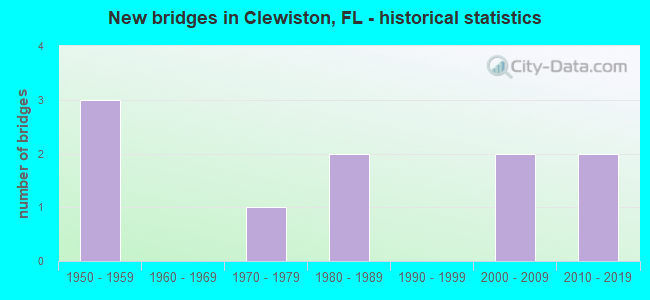
- New bridges - historical statistics
- 31950-1959
- 11970-1979
- 21980-1989
- 22000-2009
- 22010-2019


- Bridge Condition - Deck
- 11.1%Very good
- 77.8%Good
- 11.1%Fair

- Bridge Condition - Superstructure
- 11.1%Very good
- 77.8%Good
- 11.1%Fair

- Bridge Condition - Substructure
- 11.1%Very good
- 88.9%Good

- Bridge Condition - Channel
- 12.5%Excellent
- 75.0%Good
- 12.5%Satisfactory
Find on map >> Show street view
Structure Number: 50801, Location: 0.5 MI EAST OF CR-720 (Lat: 26.794569, Lng: -80.968692), Route carried "on" structure: ServiceState lands road , Year Built: 1980, Status: Open, Structure Length: 2.94m (9.65ft), Average Daily Traffic: 21 (year 2022), Truck Traffic: 1%, Average Future Daily Traffic: 33 (year 2042), Design Load: HS 20, Features Intersected: LAKE OKEECHOBEE RIM CNL, Facility Carried by Structure: HERBERT HOOVER DYK
Minimum Vertical Clearance: 30+ m (98+ ft), Kilometerpoint: 0.000, Lanes on structure: 1, Owner: State Agenciy, Approaching Roadway Width: 5.1m (16.7ft), Material/Design: Concrete, Design/Construction: Slab, Number Of Spans In Main Unit: 4, Length of Maximum Span: 7.5m (24.6ft), Curb or Sidewalk Widths: Left: 0.2m (0.7ft), Right: 0.2m (0.7ft), Curb-To-Curb Width: 5.5m (18.0ft), Out-to-Out Width: 6.1m (20.0ft)
Condition: Deck: Good, Superstructure: Good, Substructure: Good, Channel: Excellent, Operating Rating: 67.7 metric tons, Method Used To Determine Operating Rating: Load Factor (LF), Inventory Rating: 40.6 metric tons, Method Used To Determine Inventory Rating: Load Factor (LF), Structural Evaluation: Better than present minimum criteria, Deck Geometry: Meets minimum limits, Waterway Adequacy: Superior to present desirable criteria, Approach Roadway Alignment: Better than present minimum criteria, Designated Inspection Frequency: Every 24 months, Underwater Inspection Frequency: Every 24 months, Inspection Date: Febuary 2022, Underwater Inspection Date: January 2022, Deck Structure Type: Concrete Cast-file-Place
Find on map >> Show street view
Structure Number: 54016, Location: 0.7MI NORTH OF CR-720 (Lat: 26.810667, Lng: -80.985611), Route carried "on" structure: County highway , Year Built: 1955, Status: Posted for load-capacity, Structure Length: 2.94m (9.65ft), Average Daily Traffic: 55 (year 2021), Truck Traffic: 1%, Average Future Daily Traffic: 72 (year 2041), Design Load: HS 20, Features Intersected: UNCLE JOES CANAL, Facility Carried by Structure: GRIFFIN RD
Minimum Vertical Clearance: 30+ m (98+ ft), Kilometerpoint: 0.000, Lanes on structure: 2, Owner: County Highway Agency, Approaching Roadway Width: 6.1m (20.0ft), Material/Design: Prestressed concrete, Design/Construction: Slab, Number Of Spans In Main Unit: 3, Length of Maximum Span: 9.8m (32.2ft), Curb or Sidewalk Widths: Left: 0.3m (1.0ft), Right: 0.3m (1.0ft), Curb-To-Curb Width: 5.6m (18.4ft), Out-to-Out Width: 6.1m (20.0ft)
Condition: Deck: Fair, Superstructure: Fair, Substructure: Good, Channel: Good, Operating Rating: 49.6 metric tons, Method Used To Determine Operating Rating: Load Factor (LF), Inventory Rating: 29.8 metric tons, Method Used To Determine Inventory Rating: Load Factor (LF), Structural Evaluation: Somewhat better than minimum adequacy, Deck Geometry: Meets minimum limits, Waterway Adequacy: Equal to present desirable criteria, Approach Roadway Alignment: Equal to present minimum criteria, Designated Inspection Frequency: Every 24 months, Underwater Inspection Frequency: Every 24 months, Inspection Date: September 2021, Underwater Inspection Date: August 2021, Deck Structure Type: Concrete Precast Panels
Find on map >> Show street view
Structure Number: 7003, Location: 0.25MI E of FRANCISCO ST (Lat: 26.754336, Lng: -80.918642), Route carried "on" structure: US 27, Year Built: 1958, Year Reconstructed: 2006, Status: Open, Structure Length: 3.66m (12.01ft), Average Daily Traffic: 9,700 (year 2021), Truck Traffic: 24%, Average Future Daily Traffic: 16,830 (year 2041), Design Load: HS 20+Mod, Features Intersected: INDUSTRIAL CANAL
Minimum Vertical Clearance: 30.45m (99.90ft), Kilometerpoint: 3.492, Lanes on structure: 2, Base Highway Network: Yes, Owner: State Highway Agency, Approaching Roadway Width: 8.8m (28.9ft), Material/Design: Prestressed concrete, Design/Construction: Stringer/Multi-beam, Number Of Spans In Main Unit: 3, Length of Maximum Span: 12.2m (40.0ft), Curb or Sidewalk Widths: Left: 0.0m, Right: 2.4m (7.9ft), Curb-To-Curb Width: 8.8m (28.9ft), Out-to-Out Width: 13.0m (42.7ft)
Condition: Deck: Good, Superstructure: Good, Substructure: Good, Channel: Good, Operating Rating: 69.9 metric tons, Method Used To Determine Operating Rating: Load Factor (LF), Inventory Rating: 41.8 metric tons, Method Used To Determine Inventory Rating: Load Factor (LF), Structural Evaluation: Better than present minimum criteria, Deck Geometry: High priority of corrective action, Waterway Adequacy: Equal to present desirable criteria, Approach Roadway Alignment: Equal to present desirable criteria, Designated Inspection Frequency: Every 24 months, Underwater Inspection Frequency: Every 24 months, Inspection Date: May 2021, Underwater Inspection Date: April 2021, Deck Structure Type: Concrete Cast-file-Place
Find on map >> Show street view
Structure Number: 70031, Location: 0.25MI E OF FRANCISCO ST (Lat: 26.754150, Lng: -80.918619), Route carried "on" structure: US 27, Year Built: 1958, Status: Open, Structure Length: 3.66m (12.01ft), Average Daily Traffic: 9,700 (year 2021), Truck Traffic: 24%, Average Future Daily Traffic: 16,830 (year 2041), Design Load: HS 20+Mod, Features Intersected: INDUSTRIAL CANAL
Minimum Vertical Clearance: 30.45m (99.90ft), Kilometerpoint: 3.492, Lanes on structure: 2, Base Highway Network: Yes, Owner: State Highway Agency, Approaching Roadway Width: 8.5m (27.9ft), Material/Design: Prestressed concrete, Design/Construction: Stringer/Multi-beam, Number Of Spans In Main Unit: 3, Length of Maximum Span: 12.2m (40.0ft), Curb or Sidewalk Widths: Left: 1.5m (4.9ft), Right: 0.0m, Curb-To-Curb Width: 8.5m (27.9ft), Out-to-Out Width: 11.3m (37.1ft)
Condition: Deck: Good, Superstructure: Good, Substructure: Good, Channel: Good, Operating Rating: 69.7 metric tons, Method Used To Determine Operating Rating: Load Factor (LF), Inventory Rating: 41.7 metric tons, Method Used To Determine Inventory Rating: Load Factor (LF), Structural Evaluation: Better than present minimum criteria, Deck Geometry: High priority of corrective action, Waterway Adequacy: Equal to present desirable criteria, Approach Roadway Alignment: Equal to present desirable criteria, Designated Inspection Frequency: Every 24 months, Underwater Inspection Frequency: Every 24 months, Inspection Date: May 2021, Underwater Inspection Date: April 2021, Deck Structure Type: Concrete Cast-file-Place
Find on map >> Show street view
Structure Number: 70054, Location: 2.0 MILES WEST OF US-27 (Lat: 26.739872, Lng: -80.918922), Route carried "on" structure: County highway 832, Year Built: 1976, Status: Open, Structure Length: 4.57m (14.99ft), Average Daily Traffic: 4,228 (year 2021), Truck Traffic: 10%, Average Future Daily Traffic: 7,262 (year 2041), Design Load: HS 20, Features Intersected: INDUSTRIAL CANAL
Minimum Vertical Clearance: 30+ m (98+ ft), Kilometerpoint: 3.293, Lanes on structure: 2, Owner: County Highway Agency, Approaching Roadway Width: 7.3m (24.0ft), Skew: 1 degrees, Material/Design: Concrete continuous, Design/Construction: Slab, Number Of Spans In Main Unit: 5, Length of Maximum Span: 9.3m (30.5ft), Curb-To-Curb Width: 12.3m (40.4ft), Out-to-Out Width: 12.9m (42.3ft)
Condition: Deck: Good, Superstructure: Good, Substructure: Good, Channel: Good, Operating Rating: 49.8 metric tons, Method Used To Determine Operating Rating: Load Factor (LF), Inventory Rating: 29.8 metric tons, Method Used To Determine Inventory Rating: Load Factor (LF), Structural Evaluation: Better than present minimum criteria, Deck Geometry: Equal to present minimum criteria, Waterway Adequacy: Better than present minimum criteria, Approach Roadway Alignment: Equal to present desirable criteria, Designated Inspection Frequency: Every 24 months, Underwater Inspection Frequency: Every 24 months, Inspection Date: June 2021, Underwater Inspection Date: May 2021, Deck Structure Type: Concrete Cast-file-Place, Wearing Surface/Protective System: Wearing Surface: Monolithic Concrete
Find on map >> Show street view
Structure Number: 7007, Location: 7.5 mi. E of SR-80 (Lat: 26.754239, Lng: -80.959525), Route carried "on" structure: US 27, Year Built: 2000, Status: Open, Structure Length: 3.60m (11.81ft), Average Daily Traffic: 9,450 (year 2021), Truck Traffic: 25%, Average Future Daily Traffic: 16,396 (year 2041), Design Load: HS 20+Mod, Features Intersected: SUGARLAND CANAL
Minimum Vertical Clearance: 30.45m (99.90ft), Kilometerpoint: 7.561, Lanes on structure: 3, Base Highway Network: Yes, Owner: State Highway Agency, Approaching Roadway Width: 15.6m (51.2ft), Material/Design: Prestressed concrete, Design/Construction: Stringer/Multi-beam, Number Of Spans In Main Unit: 3, Length of Maximum Span: 12.0m (39.4ft), Curb-To-Curb Width: 15.6m (51.2ft), Out-to-Out Width: 16.5m (54.1ft)
Condition: Deck: Good, Superstructure: Good, Substructure: Good, Channel: Good, Operating Rating: 60.4 metric tons, Method Used To Determine Operating Rating: Load Factor (LF), Inventory Rating: 36.3 metric tons, Method Used To Determine Inventory Rating: Load Factor (LF), Structural Evaluation: Better than present minimum criteria, Deck Geometry: Equal to present minimum criteria, Waterway Adequacy: Equal to present desirable criteria, Approach Roadway Alignment: Equal to present desirable criteria, Designated Inspection Frequency: Every 24 months, Underwater Inspection Frequency: Every 24 months, Inspection Date: May 2021, Underwater Inspection Date: April 2021, Deck Structure Type: Concrete Cast-file-Place
Find on map >> Show street view
Structure Number: 70071, Location: 7.5 mi. E OF SR-80 (Lat: 26.753992, Lng: -80.959497), Route carried "on" structure: US 27, Year Built: 2000, Status: Open, Structure Length: 3.61m (11.84ft), Average Daily Traffic: 9,450 (year 2021), Truck Traffic: 25%, Average Future Daily Traffic: 16,396 (year 2041), Design Load: HS 20+Mod, Features Intersected: SUGARLAND CANAL
Minimum Vertical Clearance: 30.45m (99.90ft), Kilometerpoint: 7.561, Lanes on structure: 2, Base Highway Network: Yes, Owner: State Highway Agency, Approaching Roadway Width: 11.9m (39.0ft), Material/Design: Prestressed concrete, Design/Construction: Stringer/Multi-beam, Number Of Spans In Main Unit: 3, Length of Maximum Span: 12.0m (39.4ft), Curb-To-Curb Width: 11.9m (39.0ft), Out-to-Out Width: 13.2m (43.3ft)
Condition: Deck: Good, Superstructure: Very good, Substructure: Good, Channel: Good, Operating Rating: 60.6 metric tons, Method Used To Determine Operating Rating: Load Factor (LF), Inventory Rating: 36.4 metric tons, Method Used To Determine Inventory Rating: Load Factor (LF), Structural Evaluation: Better than present minimum criteria, Deck Geometry: Better than present minimum criteria, Waterway Adequacy: Equal to present desirable criteria, Approach Roadway Alignment: Equal to present desirable criteria, Designated Inspection Frequency: Every 24 months, Underwater Inspection Frequency: Every 24 months, Inspection Date: May 2021, Underwater Inspection Date: April 2021, Deck Structure Type: Concrete Cast-file-Place
Find on map >> Show street view
Structure Number: 70081, Location: 2.9 MI E/O CR-833 (Lat: 26.754444, Lng: -81.081667), Route carried "on" structure: State highway 80, Year Built: 2013, Status: Open, Structure Length: 5.97m (19.59ft), Average Daily Traffic: 6,500 (year 2021), Truck Traffic: 23%, Average Future Daily Traffic: 11,278 (year 2041), Design Load: HL 93, Features Intersected: US-27
Minimum Vertical Clearance: 30.45m (99.90ft), Kilometerpoint: 3.201, Lanes on structure: 2, Lanes under structure: 4, Base Highway Network: Yes, Owner: State Highway Agency, Approaching Roadway Width: 15.5m (50.9ft), Skew: 20 degrees, Material/Design: Prestressed concrete, Design/Construction: Stringer/Multi-beam, Number Of Spans In Main Unit: 2, Length of Maximum Span: 29.9m (98.1ft), Curb-To-Curb Width: 15.5m (50.9ft), Out-to-Out Width: 16.2m (53.1ft)
Condition: Deck: Very good, Superstructure: Good, Substructure: Very good, Operating Rating: 36.6 metric tons, Method Used To Determine Operating Rating: Load and Resistance Factor (LRFR), Inventory Rating: 32.7 metric tons, Method Used To Determine Inventory Rating: Load and Resistance Factor (LRFR), Structural Evaluation: Better than present minimum criteria, Deck Geometry: Superior to present desirable criteria, Underclear: Superior to present desirable criteria, Approach Roadway Alignment: Better than present minimum criteria, Designated Inspection Frequency: Every 24 months, Inspection Date: June 2021, Deck Structure Type: Concrete Cast-file-Place, Wearing Surface/Protective System: Wearing Surface: Monolithic Concrete
Find on map >> Show street view
Structure Number: 74024, Location: AT US-27/SR-80 (Lat: 26.753792, Lng: -80.960269), Route carried "on" structure: County highway , Year Built: 1987, Year Reconstructed: 2000, Status: Open, Structure Length: 1.71m (5.61ft), Average Daily Traffic: 580 (year 2021), Truck Traffic: 1%, Average Future Daily Traffic: 720 (year 2041), Design Load: HS 20, Features Intersected: SUGARLAND CANAL, Facility Carried by Structure: LEWIS BLVD
Minimum Vertical Clearance: 30+ m (98+ ft), Kilometerpoint: 3.289, Lanes on structure: 2, Owner: County Highway Agency, Approaching Roadway Width: 6.8m (22.3ft), Material/Design: Prestressed concrete, Design/Construction: Slab, Number Of Spans In Main Unit: 2, Length of Maximum Span: 8.7m (28.5ft), Curb-To-Curb Width: 15.1m (49.5ft), Out-to-Out Width: 15.7m (51.5ft)
Condition: Deck: Good, Superstructure: Good, Substructure: Good, Channel: Satisfactory, Operating Rating: 49.2 metric tons, Method Used To Determine Operating Rating: Load Factor (LF), Inventory Rating: 29.5 metric tons, Method Used To Determine Inventory Rating: Load Factor (LF), Structural Evaluation: Better than present minimum criteria, Deck Geometry: Superior to present desirable criteria, Waterway Adequacy: Better than present minimum criteria, Approach Roadway Alignment: Equal to present minimum criteria, Designated Inspection Frequency: Every 24 months, Underwater Inspection Frequency: Every 24 months, Inspection Date: June 2021, Underwater Inspection Date: May 2021, Deck Structure Type: Concrete Precast Panels, Wearing Surface/Protective System: Wearing Surface: Bituminous
Find on map >> Show street view
Structure Number: 70081, Location: 2.9 MI E/O CR-833 (Lat: 26.754444, Lng: -81.081667), Route carried "under" structure: State highway 27, Year Built: 2013, Structure Length: 0. m, Average Daily Traffic: 15,000 (year 2021), Truck Traffic: 34%, Features Intersected: US-27, Facility Carried by Structure: SR-80
Minimum Vertical Clearance: 5.46m (17.91ft), Kilometerpoint: 19.621, Lanes on structure: 2, Lanes under structure: 4, Material/Design: Prestressed concrete, Design/Construction: Stringer/Multi-beam, Length of Maximum Span: 29.9m (98.1ft)