Bridge Statistics for Claymont, Delaware (DE)
Condition, Traffic, Stress, Structural Evaluation, Project Costs
- National Bridge Inventory (NBI) Statistics
- 40Number of bridges
- 322ft / 98.3mTotal length
- $13,874,000Total costs
- 1,129,700Total average daily traffic
- 123,117Total average daily truck traffic
- National Bridge Inventory (NBI) Registered Bridges for Claymont
- No street view available for this location
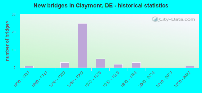
- New bridges - historical statistics
- 11930-1939
- 31950-1959
- 251960-1969
- 51970-1979
- 21980-1989
- 31990-1999
- 12020-2022
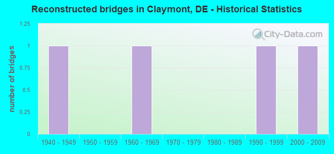
- Reconstructed bridges - Historical Statistics
- 11940-1949
- 01950-1959
- 11960-1969
- 01970-1979
- 01980-1989
- 11990-1999
- 12000-2009
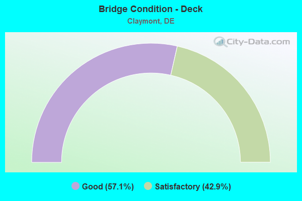
- Bridge Condition - Deck
- 57.1%Good
- 42.9%Satisfactory
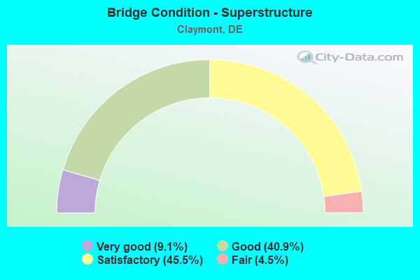
- Bridge Condition - Superstructure
- 9.1%Very good
- 40.9%Good
- 45.5%Satisfactory
- 4.5%Fair
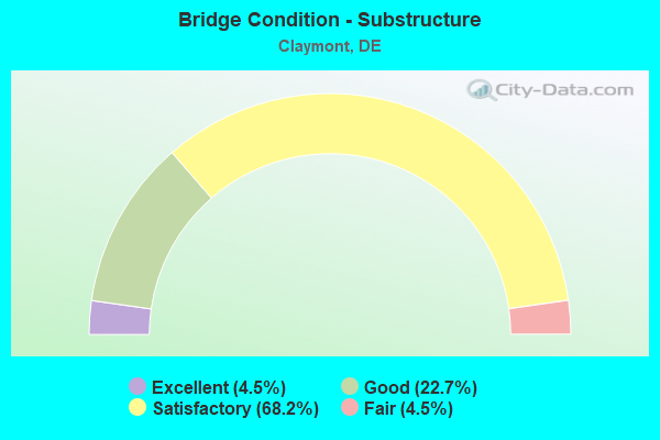
- Bridge Condition - Substructure
- 4.5%Excellent
- 22.7%Good
- 68.2%Satisfactory
- 4.5%Fair
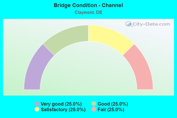
- Bridge Condition - Channel
- 25.0%Very good
- 25.0%Good
- 25.0%Satisfactory
- 25.0%Fair
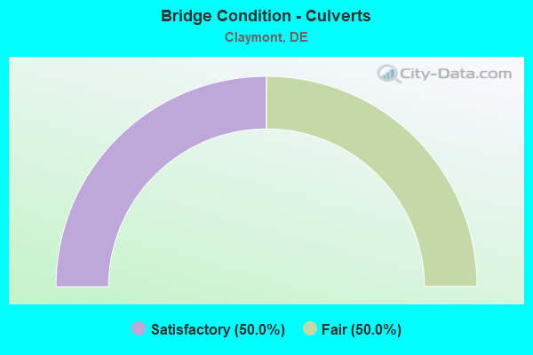
- Bridge Condition - Culverts
- 50.0%Satisfactory
- 50.0%Fair
Find on map >> Show street view
Structure Number: 1054 207, Location: CLAYMONT (Lat: 39.810200, Lng: -75.459219), Route carried "on" structure: County highway 207, Year Built: 1964, Year Reconstructed: 2003, Status: Open, Structure Length: 1.41m (4.63ft), Average Daily Traffic: 7,729 (year 2018), Truck Traffic: 9%, Average Future Daily Traffic: 9,697 (year 2042), Design Load: HS 20, Features Intersected: NAAMANS CREEK, Facility Carried by Structure: DARLEY RD
Minimum Vertical Clearance: 30.48m (100.00ft), Kilometerpoint: 2.660, Lanes on structure: 2, Owner: State Highway Agency, Approaching Roadway Width: 13.4m (44.0ft), Material/Design: Prestressed concrete, Design/Construction: Box Beam or Girders - Multiple, Number Of Spans In Main Unit: 1, Length of Maximum Span: 12.5m (41.0ft), Curb or Sidewalk Widths: Left: 1.2m (3.9ft), Right: 1.2m (3.9ft), Curb-To-Curb Width: 13.4m (44.0ft), Out-to-Out Width: 16.5m (54.1ft)
Condition: Deck: Good, Superstructure: Very good, Substructure: Good, Channel: Good, Operating Rating: 65.1 metric tons, Method Used To Determine Operating Rating: Load and Resistance Factor Rating (LRFR) rating reported by rating factor(RF) method using HL-93 loadings, Inventory Rating: 50.9 metric tons, Method Used To Determine Inventory Rating: Load and Resistance Factor Rating (LRFR) rating reported by rating factor(RF) method using HL-93 loadings, Structural Evaluation: Better than present minimum criteria, Deck Geometry: Equal to present minimum criteria, Waterway Adequacy: Equal to present desirable criteria, Approach Roadway Alignment: Equal to present desirable criteria, Designated Inspection Frequency: Every 24 months, Inspection Date: March 2020, Deck Structure Type: Concrete Cast-file-Place, Wearing Surface/Protective System: Wearing Surface: Monolithic Concrete, Deck Protection: Epoxy Coated Reinforcing
Find on map >> Show street view
Structure Number: 1054A017, Location: WEST OF MARCUS HOOK (Lat: 39.813114, Lng: -75.446064), Route carried "on" structure: State highway 92, Year Built: 1988, Status: Open, Structure Length: 1.36m (4.46ft), Average Daily Traffic: 15,265 (year 2018), Truck Traffic: 6%, Average Future Daily Traffic: 19,153 (year 2042), Design Load: HS 20, Features Intersected: NAAMANS CREEK
Minimum Vertical Clearance: 30.48m (100.00ft), Kilometerpoint: 8.610, Lanes on structure: 4, Base Highway Network: Yes, Owner: State Highway Agency, Approaching Roadway Width: 28.7m (94.2ft), Skew: 20 degrees, Material/Design: Prestressed concrete, Design/Construction: Box Beam or Girders - Multiple, Number Of Spans In Main Unit: 1, Length of Maximum Span: 12.6m (41.3ft), Curb or Sidewalk Widths: Left: 1.5m (4.9ft), Right: 1.5m (4.9ft), Curb-To-Curb Width: 28.7m (94.2ft), Out-to-Out Width: 33.2m (108.9ft)
Condition: Deck: Good, Superstructure: Good, Substructure: Satisfactory, Channel: Very good, Operating Rating: 43.1 metric tons, Method Used To Determine Operating Rating: Load and Resistance Factor Rating (LRFR) rating reported by rating factor(RF) method using HL-93 loadings, Inventory Rating: 34.0 metric tons, Method Used To Determine Inventory Rating: Load and Resistance Factor Rating (LRFR) rating reported by rating factor(RF) method using HL-93 loadings, Structural Evaluation: Equal to present minimum criteria, Deck Geometry: Superior to present desirable criteria, Waterway Adequacy: Equal to present desirable criteria, Approach Roadway Alignment: Equal to present desirable criteria, Designated Inspection Frequency: Every 24 months, Inspection Date: April 2020, Deck Structure Type: Concrete Cast-file-Place, Wearing Surface/Protective System: Wearing Surface: Monolithic Concrete, Deck Protection: Epoxy Coated Reinforcing
Find on map >> Show street view
Structure Number: 1055 207, Location: WEST OF NAAMANS (Lat: 39.808642, Lng: -75.457467), Route carried "on" structure: County highway 207, Year Built: 1959, Status: Open, Structure Length: 1.37m (4.49ft), Average Daily Traffic: 7,729 (year 2018), Truck Traffic: 9%, Average Future Daily Traffic: 9,697 (year 2042), Design Load: HS 20, Features Intersected: NAAMANS CREEK, Facility Carried by Structure: DARLEY RD
Minimum Vertical Clearance: 30.48m (100.00ft), Kilometerpoint: 2.880, Lanes on structure: 2, Owner: State Highway Agency, Approaching Roadway Width: 12.8m (42.0ft), Material/Design: Prestressed concrete, Design/Construction: Box Beam or Girders - Multiple, Number Of Spans In Main Unit: 1, Length of Maximum Span: 12.7m (41.7ft), Curb or Sidewalk Widths: Left: 1.2m (3.9ft), Right: 1.2m (3.9ft), Curb-To-Curb Width: 13.4m (44.0ft), Out-to-Out Width: 16.5m (54.1ft)
Condition: Deck: Satisfactory, Superstructure: Satisfactory, Substructure: Satisfactory, Channel: Satisfactory, Operating Rating: 44.4 metric tons, Method Used To Determine Operating Rating: Load and Resistance Factor Rating (LRFR) rating reported by rating factor(RF) method using HL-93 loadings, Inventory Rating: 34.7 metric tons, Method Used To Determine Inventory Rating: Load and Resistance Factor Rating (LRFR) rating reported by rating factor(RF) method using HL-93 loadings, Structural Evaluation: Equal to present minimum criteria, Deck Geometry: Equal to present minimum criteria, Waterway Adequacy: Better than present minimum criteria, Approach Roadway Alignment: Equal to present desirable criteria, Designated Inspection Frequency: Every 24 months, Inspection Date: March 2020, Deck Structure Type: Concrete Precast Panels, Wearing Surface/Protective System: Wearing Surface: Bituminous
Find on map >> Show street view
Structure Number: 1056 207, Location: WEST OF NAAMANS (Lat: 39.807217, Lng: -75.456244), Route carried "on" structure: County highway 207, Year Built: 1959, Status: Open, Structure Length: 1.36m (4.46ft), Average Daily Traffic: 7,729 (year 2018), Truck Traffic: 9%, Average Future Daily Traffic: 9,697 (year 2042), Design Load: HS 20, Features Intersected: NAAMANS CREEK, Facility Carried by Structure: DARLEY RD
Minimum Vertical Clearance: 30.48m (100.00ft), Kilometerpoint: 3.070, Lanes on structure: 2, Owner: State Highway Agency, Approaching Roadway Width: 12.8m (42.0ft), Material/Design: Prestressed concrete, Design/Construction: Box Beam or Girders - Multiple, Number Of Spans In Main Unit: 1, Length of Maximum Span: 12.7m (41.7ft), Curb or Sidewalk Widths: Left: 1.2m (3.9ft), Right: 1.2m (3.9ft), Curb-To-Curb Width: 13.4m (44.0ft), Out-to-Out Width: 16.5m (54.1ft)
Condition: Deck: Satisfactory, Superstructure: Satisfactory, Substructure: Good, Channel: Satisfactory, Operating Rating: 58.0 metric tons, Method Used To Determine Operating Rating: Load and Resistance Factor Rating (LRFR) rating reported by rating factor(RF) method using HL-93 loadings, Inventory Rating: 39.5 metric tons, Method Used To Determine Inventory Rating: Load and Resistance Factor Rating (LRFR) rating reported by rating factor(RF) method using HL-93 loadings, Structural Evaluation: Equal to present minimum criteria, Deck Geometry: Equal to present minimum criteria, Waterway Adequacy: Better than present minimum criteria, Approach Roadway Alignment: Equal to present desirable criteria, Designated Inspection Frequency: Every 24 months, Inspection Date: March 2020, Deck Structure Type: Concrete Precast Panels, Wearing Surface/Protective System: Wearing Surface: Bituminous
Find on map >> Show street view
Structure Number: 1057A024, Location: NAAMANS (Lat: 39.809639, Lng: -75.442675), Route carried "on" structure: US 13, Year Built: 1997, Status: Open, Structure Length: 2.40m (7.87ft), Average Daily Traffic: 13,391 (year 2019), Truck Traffic: 9%, Average Future Daily Traffic: 16,802 (year 2043), Design Load: HS 20+Mod, Features Intersected: NAAMANS CREEK/HAUL ROAD, Facility Carried by Structure: PHILADELPHIA PIKE
Minimum Vertical Clearance: 30.48m (100.00ft), Kilometerpoint: 12.907, Lanes on structure: 6, Base Highway Network: Yes, Owner: State Highway Agency, Approaching Roadway Width: 15.8m (51.8ft), Skew: 22 degrees, Material/Design: Prestressed concrete, Design/Construction: Stringer/Multi-beam, Number Of Spans In Main Unit: 1, Length of Maximum Span: 23.2m (76.1ft), Curb or Sidewalk Widths: Left: 2.4m (7.9ft), Right: 1.8m (5.9ft), Curb-To-Curb Width: 28.7m (94.2ft), Out-to-Out Width: 33.5m (109.9ft)
Condition: Deck: Good, Superstructure: Good, Substructure: Satisfactory, Channel: Very good, Operating Rating: 28.2 metric tons, Method Used To Determine Operating Rating: Load and Resistance Factor Rating (LRFR) rating reported by rating factor(RF) method using HL-93 loadings, Inventory Rating: 20.4 metric tons, Method Used To Determine Inventory Rating: Load and Resistance Factor Rating (LRFR) rating reported by rating factor(RF) method using HL-93 loadings, Structural Evaluation: Somewhat better than minimum adequacy, Deck Geometry: Superior to present desirable criteria, Waterway Adequacy: Equal to present desirable criteria, Approach Roadway Alignment: Equal to present desirable criteria, Designated Inspection Frequency: Every 24 months, Inspection Date: March 2021, Bridge Improvement Cost: $1,000, Total Project Cost: $1,289,000, Deck Structure Type: Concrete Cast-file-Place, Wearing Surface/Protective System: Wearing Surface: Monolithic Concrete, Deck Protection: Epoxy Coated Reinforcing
Find on map >> Show street view
Structure Number: 1061, Location: WEST OF CLAYMONT (Lat: 39.804083, Lng: -75.470556), Route carried "on" structure: City street , Year Built: 1958, Status: Open, Structure Length: 1.07m (3.51ft), Average Daily Traffic: 99 (year 2019), Truck Traffic: 8%, Average Future Daily Traffic: 124 (year 2043), Features Intersected: SOUTH BRANCH NAAMANS CK, Facility Carried by Structure: GLENROCK DR
Minimum Vertical Clearance: 30.48m (100.00ft), Kilometerpoint: 0.756, Lanes on structure: 2, Owner: State Highway Agency, Approaching Roadway Width: 11.0m (36.1ft), Material/Design: Steel, Design/Construction: Stringer/Multi-beam, Number Of Spans In Main Unit: 1, Length of Maximum Span: 10.1m (33.1ft), Curb or Sidewalk Widths: Left: 1.0m (3.3ft), Right: 1.0m (3.3ft), Curb-To-Curb Width: 11.0m (36.1ft), Out-to-Out Width: 13.7m (44.9ft)
Condition: Deck: Satisfactory, Superstructure: Fair, Substructure: Satisfactory, Channel: Very good, Operating Rating: 97.2 metric tons, Method Used To Determine Operating Rating: Load and Resistance Factor Rating (LRFR) rating reported by rating factor(RF) method using HL-93 loadings, Inventory Rating: 76.8 metric tons, Method Used To Determine Inventory Rating: Load and Resistance Factor Rating (LRFR) rating reported by rating factor(RF) method using HL-93 loadings, Structural Evaluation: Somewhat better than minimum adequacy, Deck Geometry: Superior to present desirable criteria, Waterway Adequacy: Better than present minimum criteria, Approach Roadway Alignment: Equal to present desirable criteria, Length Of Structure Improvement: 1.07m (3.51ft), Designated Inspection Frequency: Every 24 months, Inspection Date: Febuary 2021, Bridge Improvement Cost: $157,000, Roadway Improvement Cost: $16,000, Total Project Cost: $235,000, Deck Structure Type: Concrete Cast-file-Place, Wearing Surface/Protective System: Wearing Surface: Bituminous
Find on map >> Show street view
Structure Number: 1063, Location: GWINHURST (Lat: 39.792008, Lng: -75.474700), Route carried "on" structure: City street , Year Built: 1980, Status: Open, Structure Length: 0.82m (2.69ft), Average Daily Traffic: 99 (year 2018), Truck Traffic: 13%, Average Future Daily Traffic: 124 (year 2042), Design Load: HS 20, Features Intersected: TRIB OF HOLLY OAK CREEK, Facility Carried by Structure: LINCOLN AVE
Minimum Vertical Clearance: 30.48m (100.00ft), Kilometerpoint: 0.966, Lanes on structure: 2, Owner: State Highway Agency, Approaching Roadway Width: 8.1m (26.6ft), Skew: 2 degrees, Material/Design: Concrete, Design/Construction: Culvert, Number Of Spans In Main Unit: 4, Length of Maximum Span: 1.7m (5.6ft)
Condition: Channel: Satisfactory, Culverts: Fair, Operating Rating: 54.4 metric tons, Method Used To Determine Operating Rating: Field evaluation and documented engineering judgment, Inventory Rating: 32.7 metric tons, Method Used To Determine Inventory Rating: Field evaluation and documented engineering judgment, Structural Evaluation: Somewhat better than minimum adequacy, Waterway Adequacy: Better than present minimum criteria, Approach Roadway Alignment: Equal to present desirable criteria, Designated Inspection Frequency: Every 24 months, Inspection Date: Febuary 2020
Find on map >> Show street view
Structure Number: 1065, Location: SOUTHEAST OF ARDEN (Lat: 39.798550, Lng: -75.478867), Route carried "on" structure: City street , Year Built: 2020, Status: Open, Structure Length: 0.85m (2.79ft), Average Daily Traffic: 99 (year 2020), Average Future Daily Traffic: 123 (year 2038), Design Load: HL 93, Features Intersected: PERKINS RUN, Facility Carried by Structure: PARKSIDE BLVD
Minimum Vertical Clearance: 8.20m (26.90ft), Kilometerpoint: 0.322, Lanes on structure: 2, Owner: State Highway Agency, Approaching Roadway Width: 10.8m (35.4ft), Material/Design: Concrete, Design/Construction: Arch - Deck, Number Of Spans In Main Unit: 1, Length of Maximum Span: 8.5m (27.9ft), Curb-To-Curb Width: 10.8m (35.4ft), Out-to-Out Width: 22.0m (72.2ft)
Condition: Superstructure: Very good, Substructure: Excellent, Channel: Good, Operating Rating: 71.0 metric tons, Method Used To Determine Operating Rating: Load and Resistance Factor Rating (LRFR) rating reported by rating factor(RF) method using HL-93 loadings, Inventory Rating: 59.9 metric tons, Method Used To Determine Inventory Rating: Load and Resistance Factor Rating (LRFR) rating reported by rating factor(RF) method using HL-93 loadings, Structural Evaluation: Equal to present desirable criteria, Deck Geometry: Superior to present desirable criteria, Waterway Adequacy: Better than present minimum criteria, Approach Roadway Alignment: Equal to present desirable criteria, Designated Inspection Frequency: Every 24 months, Inspection Date: December 2020
Find on map >> Show street view
Structure Number: 1073C017, Location: N. OF CLAYMONT (Lat: 39.818919, Lng: -75.464125), Route carried "on" structure: State highway 92, Year Built: 1992, Status: Open, Structure Length: 4.72m (15.49ft), Average Daily Traffic: 11,360 (year 2018), Truck Traffic: 6%, Average Future Daily Traffic: 14,253 (year 2042), Design Load: HS 20, Features Intersected: CSX RAILROAD
Minimum Vertical Clearance: 30.48m (100.00ft), Kilometerpoint: 7.030, Lanes on structure: 2, Base Highway Network: Yes, Owner: State Highway Agency, Approaching Roadway Width: 12.8m (42.0ft), Skew: 2 degrees, Material/Design: Steel continuous, Design/Construction: Stringer/Multi-beam, Number Of Spans In Main Unit: 3, Length of Maximum Span: 17.7m (58.1ft), Curb or Sidewalk Widths: Left: 0.0m, Right: 1.5m (4.9ft), Curb-To-Curb Width: 12.8m (42.0ft), Out-to-Out Width: 17.4m (57.1ft)
Condition: Deck: Good, Superstructure: Good, Substructure: Satisfactory, Operating Rating: 54.8 metric tons, Method Used To Determine Operating Rating: Load and Resistance Factor Rating (LRFR) rating reported by rating factor(RF) method using HL-93 loadings, Inventory Rating: 42.1 metric tons, Method Used To Determine Inventory Rating: Load and Resistance Factor Rating (LRFR) rating reported by rating factor(RF) method using HL-93 loadings, Structural Evaluation: Equal to present minimum criteria, Deck Geometry: Equal to present desirable criteria, Underclear: Better than present minimum criteria, Approach Roadway Alignment: Equal to present desirable criteria, Designated Inspection Frequency: Every 24 months, Inspection Date: March 2020, Deck Structure Type: Concrete Cast-file-Place, Wearing Surface/Protective System: Wearing Surface: Monolithic Concrete, Deck Protection: Epoxy Coated Reinforcing
Find on map >> Show street view
Structure Number: 1073D017, Location: N. OF CLAYMONT (Lat: 39.819031, Lng: -75.463994), Route carried "on" structure: State highway 92, Year Built: 1992, Status: Open, Structure Length: 4.72m (15.49ft), Average Daily Traffic: 11,359 (year 2018), Truck Traffic: 6%, Average Future Daily Traffic: 14,252 (year 2042), Design Load: HS 20, Features Intersected: CSX RAILROAD
Minimum Vertical Clearance: 30.48m (100.00ft), Kilometerpoint: 6.951, Lanes on structure: 2, Base Highway Network: Yes, Owner: State Highway Agency, Approaching Roadway Width: 12.8m (42.0ft), Skew: 2 degrees, Material/Design: Steel continuous, Design/Construction: Stringer/Multi-beam, Number Of Spans In Main Unit: 3, Length of Maximum Span: 17.7m (58.1ft), Curb or Sidewalk Widths: Left: 1.5m (4.9ft), Right: 0.0m, Curb-To-Curb Width: 12.8m (42.0ft), Out-to-Out Width: 17.4m (57.1ft)
Condition: Deck: Good, Superstructure: Satisfactory, Substructure: Satisfactory, Operating Rating: 54.8 metric tons, Method Used To Determine Operating Rating: Load and Resistance Factor Rating (LRFR) rating reported by rating factor(RF) method using HL-93 loadings, Inventory Rating: 42.1 metric tons, Method Used To Determine Inventory Rating: Load and Resistance Factor Rating (LRFR) rating reported by rating factor(RF) method using HL-93 loadings, Structural Evaluation: Equal to present minimum criteria, Deck Geometry: Equal to present desirable criteria, Underclear: Better than present minimum criteria, Approach Roadway Alignment: Equal to present desirable criteria, Designated Inspection Frequency: Every 24 months, Inspection Date: March 2020, Deck Structure Type: Concrete Cast-file-Place, Wearing Surface/Protective System: Wearing Surface: Monolithic Concrete, Deck Protection: Epoxy Coated Reinforcing
Find on map >> Show street view
Structure Number: 1558 05, Location: EAST OF WILMINGTON (Lat: 39.785628, Lng: -75.471369), Route carried "on" structure: US 13, Year Built: 1935, Year Reconstructed: 1940, Status: Open, Structure Length: 0.98m (3.22ft), Average Daily Traffic: 5,392 (year 2019), Truck Traffic: 9%, Average Future Daily Traffic: 6,701 (year 2042), Design Load: HS 20, Features Intersected: HOLLYOAK CREEK, Facility Carried by Structure: GOV. PRINTZ BLVD
Minimum Vertical Clearance: 30.48m (100.00ft), Kilometerpoint: 9.410, Lanes on structure: 4, Owner: State Highway Agency, Approaching Roadway Width: 19.3m (63.3ft), Skew: 20 degrees, Material/Design: Steel, Design/Construction: Stringer/Multi-beam, Number Of Spans In Main Unit: 1, Length of Maximum Span: 8.5m (27.9ft), Curb-To-Curb Width: 19.3m (63.3ft), Out-to-Out Width: 30.2m (99.1ft)
Condition: Deck: Satisfactory, Superstructure: Good, Substructure: Satisfactory, Channel: Fair, Operating Rating: 67.4 metric tons, Method Used To Determine Operating Rating: Load and Resistance Factor Rating (LRFR) rating reported by rating factor(RF) method using HL-93 loadings, Inventory Rating: 51.8 metric tons, Method Used To Determine Inventory Rating: Load and Resistance Factor Rating (LRFR) rating reported by rating factor(RF) method using HL-93 loadings, Structural Evaluation: Equal to present minimum criteria, Deck Geometry: Equal to present minimum criteria, Waterway Adequacy: Equal to present minimum criteria, Approach Roadway Alignment: Equal to present desirable criteria, Designated Inspection Frequency: Every 24 months, Inspection Date: April 2020, Deck Structure Type: Concrete Cast-file-Place, Wearing Surface/Protective System: Wearing Surface: Bituminous
Find on map >> Show street view
Structure Number: 1782 059, Location: S. OF ARDEN (Lat: 39.792867, Lng: -75.490097), Route carried "on" structure: Interstate 95, Year Built: 1967, Status: Open, Structure Length: 3.96m (12.99ft), Average Daily Traffic: 25,421 (year 2019), Truck Traffic: 9%, Average Future Daily Traffic: 31,596 (year 2042), Design Load: HS 20+Mod, Features Intersected: SILVERSIDE RD
Minimum Vertical Clearance: 30.48m (100.00ft), Kilometerpoint: 25.620, Lanes on structure: 2, Lanes under structure: 2, Base Highway Network: Yes, Owner: State Highway Agency, Approaching Roadway Width: 12.0m (39.4ft), Skew: 1 degrees, Material/Design: Steel, Design/Construction: Stringer/Multi-beam, Number Of Spans In Main Unit: 3, Length of Maximum Span: 18.6m (61.0ft), Curb-To-Curb Width: 11.6m (38.1ft), Out-to-Out Width: 12.5m (41.0ft)
Condition: Deck: Satisfactory, Superstructure: Satisfactory, Substructure: Good, Operating Rating: 61.6 metric tons, Method Used To Determine Operating Rating: Load and Resistance Factor Rating (LRFR) rating reported by rating factor(RF) method using HL-93 loadings, Inventory Rating: 47.6 metric tons, Method Used To Determine Inventory Rating: Load and Resistance Factor Rating (LRFR) rating reported by rating factor(RF) method using HL-93 loadings, Structural Evaluation: Equal to present minimum criteria, Deck Geometry: Equal to present minimum criteria, Underclear: Somewhat better than minimum adequacy, Approach Roadway Alignment: Equal to present desirable criteria, Designated Inspection Frequency: Every 24 months, Inspection Date: April 2020, Bridge Improvement Cost: $800,000, Roadway Improvement Cost: $200,000, Total Project Cost: $1,000,000, Deck Structure Type: Concrete Cast-file-Place, Wearing Surface/Protective System: Wearing Surface: Monolithic Concrete
Find on map >> Show street view
Structure Number: 1785 209, Location: N.E. OF WILMINGTON (Lat: 39.803053, Lng: -75.479839), Route carried "on" structure: County highway 209, Year Built: 1967, Status: Open, Structure Length: 7.20m (23.62ft), Average Daily Traffic: 11,371 (year 2018), Truck Traffic: 9%, Average Future Daily Traffic: 14,267 (year 2042), Design Load: HS 20, Features Intersected: I 95, Facility Carried by Structure: HARVEY RD
Minimum Vertical Clearance: 30.48m (100.00ft), Kilometerpoint: 5.230, Lanes on structure: 5, Lanes under structure: 4, Owner: State Highway Agency, Approaching Roadway Width: 12.2m (40.0ft), Skew: 30 degrees, Material/Design: Steel, Design/Construction: Stringer/Multi-beam, Number Of Spans In Main Unit: 5, Length of Maximum Span: 16.5m (54.1ft), Curb or Sidewalk Widths: Left: 0.5m (1.6ft), Right: 1.2m (3.9ft), Curb-To-Curb Width: 19.5m (64.0ft), Out-to-Out Width: 23.0m (75.5ft)
Condition: Deck: Good, Superstructure: Satisfactory, Substructure: Satisfactory, Operating Rating: 36.0 metric tons, Method Used To Determine Operating Rating: Load and Resistance Factor Rating (LRFR) rating reported by rating factor(RF) method using HL-93 loadings, Inventory Rating: 27.9 metric tons, Method Used To Determine Inventory Rating: Load and Resistance Factor Rating (LRFR) rating reported by rating factor(RF) method using HL-93 loadings, Structural Evaluation: Equal to present minimum criteria, Deck Geometry: Meets minimum limits, Underclear: High priority of corrective action, Approach Roadway Alignment: Equal to present desirable criteria, Length Of Structure Improvement: 7.20m (23.62ft), Designated Inspection Frequency: Every 24 months, Inspection Date: April 2020, Bridge Improvement Cost: $100,000, Roadway Improvement Cost: $10,000, Total Project Cost: $150,000, Deck Structure Type: Concrete Cast-file-Place, Wearing Surface/Protective System: Wearing Surface: Latex Concrete
Find on map >> Show street view
Structure Number: 1786 059, Location: S/E OF ARDEN (Lat: 39.803781, Lng: -75.470603), Route carried "on" structure: Interstate 95, Year Built: 1966, Status: Open, Structure Length: 3.46m (11.35ft), Average Daily Traffic: 61,888 (year 2018), Truck Traffic: 15%, Average Future Daily Traffic: 77,652 (year 2042), Design Load: HS 20+Mod, Features Intersected: GLENROCK DRIVE
Minimum Vertical Clearance: 30.48m (100.00ft), Kilometerpoint: 23.255, Lanes on structure: 2, Lanes under structure: 2, Base Highway Network: Yes, Owner: State Highway Agency, Approaching Roadway Width: 12.8m (42.0ft), Material/Design: Steel, Design/Construction: Stringer/Multi-beam, Number Of Spans In Main Unit: 3, Length of Maximum Span: 15.1m (49.5ft), Curb-To-Curb Width: 11.0m (36.1ft), Out-to-Out Width: 13.1m (43.0ft)
Condition: Deck: Satisfactory, Superstructure: Satisfactory, Substructure: Satisfactory, Operating Rating: 69.0 metric tons, Method Used To Determine Operating Rating: Load and Resistance Factor Rating (LRFR) rating reported by rating factor(RF) method using HL-93 loadings, Inventory Rating: 53.1 metric tons, Method Used To Determine Inventory Rating: Load and Resistance Factor Rating (LRFR) rating reported by rating factor(RF) method using HL-93 loadings, Structural Evaluation: Equal to present minimum criteria, Deck Geometry: Somewhat better than minimum adequacy, Underclear: Meets minimum limits, Approach Roadway Alignment: Equal to present desirable criteria, Designated Inspection Frequency: Every 24 months, Inspection Date: March 2020, Bridge Improvement Cost: $800,000, Roadway Improvement Cost: $200,000, Total Project Cost: $1,000,000, Deck Structure Type: Concrete Cast-file-Place, Wearing Surface/Protective System: Wearing Surface: Monolithic Concrete
Find on map >> Show street view
Structure Number: 1787 059, Location: S/E OF ARDEN (Lat: 39.803558, Lng: -75.470719), Route carried "on" structure: Interstate 95, Year Built: 1966, Status: Open, Structure Length: 3.61m (11.84ft), Average Daily Traffic: 30,080 (year 2018), Truck Traffic: 15%, Average Future Daily Traffic: 37,742 (year 2042), Design Load: HS 20+Mod, Features Intersected: GLENROCK DRIVE
Minimum Vertical Clearance: 30.48m (100.00ft), Kilometerpoint: 18.110, Lanes on structure: 2, Lanes under structure: 2, Base Highway Network: Yes, Owner: State Highway Agency, Approaching Roadway Width: 11.6m (38.1ft), Material/Design: Steel, Design/Construction: Stringer/Multi-beam, Number Of Spans In Main Unit: 3, Length of Maximum Span: 15.1m (49.5ft), Curb-To-Curb Width: 11.0m (36.1ft), Out-to-Out Width: 13.1m (43.0ft)
Condition: Deck: Satisfactory, Superstructure: Satisfactory, Substructure: Satisfactory, Operating Rating: 64.5 metric tons, Method Used To Determine Operating Rating: Load and Resistance Factor Rating (LRFR) rating reported by rating factor(RF) method using HL-93 loadings, Inventory Rating: 49.9 metric tons, Method Used To Determine Inventory Rating: Load and Resistance Factor Rating (LRFR) rating reported by rating factor(RF) method using HL-93 loadings, Structural Evaluation: Equal to present minimum criteria, Deck Geometry: Somewhat better than minimum adequacy, Underclear: Meets minimum limits, Approach Roadway Alignment: Equal to present desirable criteria, Designated Inspection Frequency: Every 24 months, Inspection Date: March 2020, Bridge Improvement Cost: $800,000, Roadway Improvement Cost: $200,000, Total Project Cost: $1,000,000, Deck Structure Type: Concrete Cast-file-Place, Wearing Surface/Protective System: Wearing Surface: Monolithic Concrete
Find on map >> Show street view
Structure Number: 1788 059, Location: CLAYMONT (Lat: 39.803497, Lng: -75.469561), Route carried "on" structure: Interstate 95, Year Built: 1966, Status: Open, Structure Length: 1.38m (4.53ft), Average Daily Traffic: 53,827 (year 2018), Truck Traffic: 15%, Average Future Daily Traffic: 67,538 (year 2042), Design Load: HS 20, Features Intersected: SO.BRANCH NAAMANS CREEK
Minimum Vertical Clearance: 30.48m (100.00ft), Kilometerpoint: 18.300, Lanes on structure: 4, Base Highway Network: Yes, Owner: State Highway Agency, Approaching Roadway Width: 39.0m (128.0ft), Skew: 2 degrees, Material/Design: Concrete, Design/Construction: Culvert, Number Of Spans In Main Unit: 3, Length of Maximum Span: 4.4m (14.4ft)
Condition: Channel: Fair, Culverts: Satisfactory, Operating Rating: 97.2 metric tons, Method Used To Determine Operating Rating: Load and Resistance Factor Rating (LRFR) rating reported by rating factor(RF) method using HL-93 loadings, Inventory Rating: 97.2 metric tons, Method Used To Determine Inventory Rating: Load and Resistance Factor Rating (LRFR) rating reported by rating factor(RF) method using HL-93 loadings, Structural Evaluation: Equal to present minimum criteria, Waterway Adequacy: Equal to present desirable criteria, Approach Roadway Alignment: Equal to present desirable criteria, Designated Inspection Frequency: Every 24 months, Inspection Date: Febuary 2020, Bridge Improvement Cost: $800,000, Roadway Improvement Cost: $200,000, Total Project Cost: $1,000,000
Find on map >> Show street view
Structure Number: 1790 059, Location: NORTH OF CLAYMONT (Lat: 39.810539, Lng: -75.459683), Route carried "on" structure: Interstate 95, Year Built: 1966, Status: Open, Structure Length: 4.04m (13.25ft), Average Daily Traffic: 26,913 (year 2018), Truck Traffic: 15%, Average Future Daily Traffic: 33,768 (year 2042), Design Load: HS 20, Features Intersected: DARLEY RD
Minimum Vertical Clearance: 30.48m (100.00ft), Kilometerpoint: 19.409, Lanes on structure: 2, Lanes under structure: 2, Base Highway Network: Yes, Owner: State Highway Agency, Approaching Roadway Width: 12.8m (42.0ft), Material/Design: Steel continuous, Design/Construction: Stringer/Multi-beam, Number Of Spans In Main Unit: 3, Length of Maximum Span: 17.7m (58.1ft), Curb-To-Curb Width: 11.4m (37.4ft), Out-to-Out Width: 12.8m (42.0ft)
Condition: Deck: Good, Superstructure: Good, Substructure: Satisfactory, Operating Rating: 51.5 metric tons, Method Used To Determine Operating Rating: Load and Resistance Factor Rating (LRFR) rating reported by rating factor(RF) method using HL-93 loadings, Inventory Rating: 39.5 metric tons, Method Used To Determine Inventory Rating: Load and Resistance Factor Rating (LRFR) rating reported by rating factor(RF) method using HL-93 loadings, Structural Evaluation: Equal to present minimum criteria, Deck Geometry: Somewhat better than minimum adequacy, Underclear: Equal to present minimum criteria, Approach Roadway Alignment: Equal to present desirable criteria, Designated Inspection Frequency: Every 24 months, Inspection Date: Febuary 2020, Bridge Improvement Cost: $800,000, Roadway Improvement Cost: $200,000, Total Project Cost: $1,000,000, Deck Structure Type: Concrete Cast-file-Place, Wearing Surface/Protective System: Wearing Surface: Latex Concrete
Find on map >> Show street view
Structure Number: 1791 059, Location: NORTH OF CLAYMONT (Lat: 39.810336, Lng: -75.459522), Route carried "on" structure: Interstate 95, Year Built: 1966, Status: Open, Structure Length: 4.04m (13.25ft), Average Daily Traffic: 26,913 (year 2018), Truck Traffic: 15%, Average Future Daily Traffic: 33,768 (year 2042), Design Load: HS 20, Features Intersected: DARLEY RD
Minimum Vertical Clearance: 30.48m (100.00ft), Kilometerpoint: 19.410, Lanes on structure: 2, Lanes under structure: 2, Base Highway Network: Yes, Owner: State Highway Agency, Approaching Roadway Width: 11.6m (38.1ft), Material/Design: Steel continuous, Design/Construction: Stringer/Multi-beam, Number Of Spans In Main Unit: 3, Length of Maximum Span: 17.7m (58.1ft), Curb-To-Curb Width: 11.4m (37.4ft), Out-to-Out Width: 12.8m (42.0ft)
Condition: Deck: Good, Superstructure: Good, Substructure: Satisfactory, Operating Rating: 51.5 metric tons, Method Used To Determine Operating Rating: Load and Resistance Factor Rating (LRFR) rating reported by rating factor(RF) method using HL-93 loadings, Inventory Rating: 39.5 metric tons, Method Used To Determine Inventory Rating: Load and Resistance Factor Rating (LRFR) rating reported by rating factor(RF) method using HL-93 loadings, Structural Evaluation: Equal to present minimum criteria, Deck Geometry: Somewhat better than minimum adequacy, Underclear: Equal to present minimum criteria, Approach Roadway Alignment: Equal to present desirable criteria, Designated Inspection Frequency: Every 24 months, Inspection Date: Febuary 2020, Bridge Improvement Cost: $800,000, Roadway Improvement Cost: $200,000, Total Project Cost: $1,000,000, Deck Structure Type: Concrete Cast-file-Place, Wearing Surface/Protective System: Wearing Surface: Latex Concrete
Find on map >> Show street view
Structure Number: 1792 06, Location: N. OF CLAYMONT (Lat: 39.812986, Lng: -75.455542), Route carried "on" structure: Interstate 495, Year Built: 1966, Year Reconstructed: 2012, Status: Open, Structure Length: 11.03m (36.19ft), Average Daily Traffic: 59,164 (year 2019), Truck Traffic: 15%, Average Future Daily Traffic: 73,536 (year 2042), Design Load: HS 20+Mod, Features Intersected: I 95 & RAMP 6202
Minimum Vertical Clearance: 30.48m (100.00ft), Kilometerpoint: 18.200, Lanes on structure: 2, Lanes under structure: 5, Base Highway Network: Yes, Owner: State Highway Agency, Approaching Roadway Width: 11.6m (38.1ft), Skew: 4 degrees, Material/Design: Steel continuous, Design/Construction: Stringer/Multi-beam, Number Of Spans In Main Unit: 5, Length of Maximum Span: 31.4m (103.0ft), Curb-To-Curb Width: 11.4m (37.4ft), Out-to-Out Width: 12.8m (42.0ft)
Condition: Deck: Good, Superstructure: Good, Substructure: Satisfactory, Operating Rating: 43.7 metric tons, Method Used To Determine Operating Rating: Load and Resistance Factor Rating (LRFR) rating reported by rating factor(RF) method using HL-93 loadings, Inventory Rating: 33.7 metric tons, Method Used To Determine Inventory Rating: Load and Resistance Factor Rating (LRFR) rating reported by rating factor(RF) method using HL-93 loadings, Structural Evaluation: Equal to present minimum criteria, Deck Geometry: Somewhat better than minimum adequacy, Underclear: High priority of replacement, Approach Roadway Alignment: Equal to present desirable criteria, Length Of Structure Improvement: 11.03m (36.19ft), Designated Inspection Frequency: Every 24 months, Inspection Date: October 2020, Bridge Improvement Cost: $800,000, Roadway Improvement Cost: $200,000, Total Project Cost: $1,000,000, Deck Structure Type: Concrete Cast-file-Place, Wearing Surface/Protective System: Wearing Surface: Monolithic Concrete
Find on map >> Show street view
Structure Number: 1795 017, Location: NORTH OF CLAYMONT (Lat: 39.815717, Lng: -75.454339), Route carried "on" structure: State highway 92, Year Built: 1966, Status: Open, Structure Length: 4.51m (14.80ft), Average Daily Traffic: 22,310 (year 2019), Truck Traffic: 5%, Average Future Daily Traffic: 27,729 (year 2042), Design Load: HS 20, Features Intersected: I 495 SOUTHBOUND
Minimum Vertical Clearance: 30.48m (100.00ft), Kilometerpoint: 7.854, Lanes on structure: 5, Lanes under structure: 2, Base Highway Network: Yes, Owner: State Highway Agency, Approaching Roadway Width: 15.8m (51.8ft), Skew: 32 degrees, Material/Design: Steel continuous, Design/Construction: Stringer/Multi-beam, Number Of Spans In Main Unit: 3, Length of Maximum Span: 19.8m (65.0ft), Curb or Sidewalk Widths: Left: 1.5m (4.9ft), Right: 1.5m (4.9ft), Curb-To-Curb Width: 19.5m (64.0ft), Out-to-Out Width: 24.4m (80.1ft)
Condition: Deck: Satisfactory, Superstructure: Satisfactory, Substructure: Satisfactory, Operating Rating: 41.8 metric tons, Method Used To Determine Operating Rating: Load and Resistance Factor Rating (LRFR) rating reported by rating factor(RF) method using HL-93 loadings, Inventory Rating: 30.8 metric tons, Method Used To Determine Inventory Rating: Load and Resistance Factor Rating (LRFR) rating reported by rating factor(RF) method using HL-93 loadings, Structural Evaluation: Equal to present minimum criteria, Deck Geometry: Meets minimum limits, Underclear: Equal to present minimum criteria, Approach Roadway Alignment: Equal to present desirable criteria, Designated Inspection Frequency: Every 24 months, Inspection Date: April 2020, Deck Structure Type: Concrete Cast-file-Place, Wearing Surface/Protective System: Wearing Surface: Latex Concrete
Find on map >> Show street view
Structure Number: 1796 017, Location: NORTH OF CLAYMONT (Lat: 39.815467, Lng: -75.453294), Route carried "on" structure: State highway 92, Year Built: 1966, Status: Open, Structure Length: 7.66m (25.13ft), Average Daily Traffic: 22,310 (year 2019), Truck Traffic: 5%, Average Future Daily Traffic: 27,729 (year 2042), Design Load: HS 20, Features Intersected: I 95/JOHN F. KENNEDY
Minimum Vertical Clearance: 5.29m (17.36ft), Kilometerpoint: 7.918, Lanes on structure: 5, Lanes under structure: 6, Base Highway Network: Yes, Owner: State Highway Agency, Approaching Roadway Width: 36.1m (118.4ft), Skew: 31 degrees, Material/Design: Steel continuous, Design/Construction: Stringer/Multi-beam, Number Of Spans In Main Unit: 2, Number Of Approach Spans: 2, Length of Maximum Span: 25.3m (83.0ft), Curb or Sidewalk Widths: Left: 1.5m (4.9ft), Right: 1.5m (4.9ft), Curb-To-Curb Width: 11.6m (38.1ft), Out-to-Out Width: 24.4m (80.1ft)
Condition: Deck: Good, Superstructure: Satisfactory, Substructure: Satisfactory, Operating Rating: 41.1 metric tons, Method Used To Determine Operating Rating: Load and Resistance Factor Rating (LRFR) rating reported by rating factor(RF) method using HL-93 loadings, Inventory Rating: 31.8 metric tons, Method Used To Determine Inventory Rating: Load and Resistance Factor Rating (LRFR) rating reported by rating factor(RF) method using HL-93 loadings, Structural Evaluation: Equal to present minimum criteria, Deck Geometry: High priority of replacement, Underclear: Somewhat better than minimum adequacy, Approach Roadway Alignment: Equal to present desirable criteria, Length Of Structure Improvement: 7.62m (25.00ft), Designated Inspection Frequency: Every 24 months, Inspection Date: April 2020, Bridge Improvement Cost: $1,000,000, Roadway Improvement Cost: $100,000, Total Project Cost: $1,100,000, Deck Structure Type: Concrete Cast-file-Place, Wearing Surface/Protective System: Wearing Surface: Monolithic Concrete
Find on map >> Show street view
Structure Number: 1797 6202, Location: WEST OF CLAYMONT (Lat: 39.813258, Lng: -75.454231), Route carried "on" structure: Ramp Interstate 6202, Year Built: 1966, Status: Open, Structure Length: 5.36m (17.59ft), Average Daily Traffic: 3,861 (year 2019), Truck Traffic: 7%, Average Future Daily Traffic: 1,406 (year 2037), Design Load: HS 20, Features Intersected: I 495 NB
Minimum Vertical Clearance: 30.48m (100.00ft), Kilometerpoint: 0.241, Lanes on structure: 1, Lanes under structure: 2, Owner: State Highway Agency, Approaching Roadway Width: 6.1m (20.0ft), Skew: 4 degrees, Material/Design: Steel, Design/Construction: Stringer/Multi-beam, Number Of Spans In Main Unit: 3, Length of Maximum Span: 17.1m (56.1ft), Curb-To-Curb Width: 6.1m (20.0ft), Out-to-Out Width: 7.6m (24.9ft)
Condition: Deck: Good, Superstructure: Good, Substructure: Good, Operating Rating: 44.4 metric tons, Method Used To Determine Operating Rating: Load and Resistance Factor Rating (LRFR) rating reported by rating factor(RF) method using HL-93 loadings, Inventory Rating: 34.3 metric tons, Method Used To Determine Inventory Rating: Load and Resistance Factor Rating (LRFR) rating reported by rating factor(RF) method using HL-93 loadings, Structural Evaluation: Better than present minimum criteria, Deck Geometry: Somewhat better than minimum adequacy, Underclear: Equal to present minimum criteria, Approach Roadway Alignment: Equal to present desirable criteria, Designated Inspection Frequency: Every 24 months, Inspection Date: April 2020, Bridge Improvement Cost: $800,000, Roadway Improvement Cost: $200,000, Total Project Cost: $1,000,000, Deck Structure Type: Concrete Cast-file-Place, Wearing Surface/Protective System: Wearing Surface: Bituminous
Find on map >> Show street view
Structure Number: 1799 06, Location: CLAYMONT (Lat: 39.809342, Lng: -75.453361), Route carried "on" structure: Interstate 495, Year Built: 1966, Year Reconstructed: 1972, Status: Open, Structure Length: 1.01m (3.31ft), Average Daily Traffic: 78,212 (year 2018), Truck Traffic: 15%, Average Future Daily Traffic: 98,135 (year 2042), Design Load: HS 20, Features Intersected: SO.BRANCH-NAAMANS CREEK, Facility Carried by Structure: VIETNAM MEM HGWY
Minimum Vertical Clearance: 30.48m (100.00ft), Kilometerpoint: 17.860, Lanes on structure: 4, Base Highway Network: Yes, Owner: State Highway Agency, Approaching Roadway Width: 24.4m (80.1ft), Skew: 20 degrees, Material/Design: Concrete, Design/Construction: Culvert, Number Of Spans In Main Unit: 2, Length of Maximum Span: 4.9m (16.1ft)
Condition: Channel: Fair, Culverts: Satisfactory, Operating Rating: 47.3 metric tons, Method Used To Determine Operating Rating: Load and Resistance Factor Rating (LRFR) rating reported by rating factor(RF) method using HL-93 loadings, Inventory Rating: 32.7 metric tons, Method Used To Determine Inventory Rating: Load and Resistance Factor Rating (LRFR) rating reported by rating factor(RF) method using HL-93 loadings, Structural Evaluation: Equal to present minimum criteria, Waterway Adequacy: Equal to present desirable criteria, Approach Roadway Alignment: Equal to present desirable criteria, Designated Inspection Frequency: Every 24 months, Inspection Date: Febuary 2020, Bridge Improvement Cost: $800,000, Roadway Improvement Cost: $200,000, Total Project Cost: $1,000,000
Find on map >> Show street view
Structure Number: 1828 06, Location: CLAYMONT (Lat: 39.785339, Lng: -75.470936), Route carried "on" structure: Interstate 495, Year Built: 1972, Status: Open, Structure Length: 0.94m (3.08ft), Average Daily Traffic: 66,485 (year 2018), Truck Traffic: 15%, Average Future Daily Traffic: 83,421 (year 2042), Design Load: HS 20+Mod, Features Intersected: HOLLYOAK CREEK
Minimum Vertical Clearance: 30.48m (100.00ft), Kilometerpoint: 15.080, Lanes on structure: 6, Base Highway Network: Yes, Owner: State Highway Agency, Approaching Roadway Width: 45.1m (148.0ft), Skew: 30 degrees, Material/Design: Concrete, Design/Construction: Culvert, Number Of Spans In Main Unit: 3, Length of Maximum Span: 2.9m (9.5ft)
Condition: Channel: Good, Culverts: Fair, Operating Rating: 50.5 metric tons, Method Used To Determine Operating Rating: Load and Resistance Factor Rating (LRFR) rating reported by rating factor(RF) method using HL-93 loadings, Inventory Rating: 39.9 metric tons, Method Used To Determine Inventory Rating: Load and Resistance Factor Rating (LRFR) rating reported by rating factor(RF) method using HL-93 loadings, Structural Evaluation: Somewhat better than minimum adequacy, Waterway Adequacy: Equal to present desirable criteria, Approach Roadway Alignment: Equal to present desirable criteria, Designated Inspection Frequency: Every 24 months, Inspection Date: March 2020, Bridge Improvement Cost: $800,000, Roadway Improvement Cost: $200,000, Total Project Cost: $1,000,000
Find on map >> Show street view
Structure Number: 1829, Location: CLAYMONT (Lat: 39.801286, Lng: -75.450944), Route carried "on" structure: City street , Year Built: 1972, Status: Open, Structure Length: 11.16m (36.61ft), Average Daily Traffic: 99 (year 2019), Truck Traffic: 8%, Average Future Daily Traffic: 123 (year 2042), Design Load: HS 20+Mod, Features Intersected: I495/VIETNAM VET MEM HGY, Facility Carried by Structure: MYRTLE AVE
Minimum Vertical Clearance: 30.48m (100.00ft), Kilometerpoint: 0.390, Lanes on structure: 2, Lanes under structure: 6, Owner: State Highway Agency, Approaching Roadway Width: 8.5m (27.9ft), Skew: 3 degrees, Material/Design: Steel continuous, Design/Construction: Stringer/Multi-beam, Number Of Spans In Main Unit: 2, Number Of Approach Spans: 2, Length of Maximum Span: 32.6m (107.0ft), Curb or Sidewalk Widths: Left: 1.5m (4.9ft), Right: 0.0m, Curb-To-Curb Width: 8.5m (27.9ft), Out-to-Out Width: 10.9m (35.8ft)
Condition: Deck: Good, Superstructure: Good, Substructure: Fair, Operating Rating: 44.4 metric tons, Method Used To Determine Operating Rating: Load and Resistance Factor Rating (LRFR) rating reported by rating factor(RF) method using HL-93 loadings, Inventory Rating: 34.3 metric tons, Method Used To Determine Inventory Rating: Load and Resistance Factor Rating (LRFR) rating reported by rating factor(RF) method using HL-93 loadings, Structural Evaluation: Somewhat better than minimum adequacy, Deck Geometry: Better than present minimum criteria, Underclear: Equal to present minimum criteria, Approach Roadway Alignment: Equal to present desirable criteria, Length Of Structure Improvement: 7.62m (25.00ft), Designated Inspection Frequency: Every 24 months, Inspection Date: November 2020, Bridge Improvement Cost: $1,000,000, Roadway Improvement Cost: $100,000, Total Project Cost: $1,100,000, Deck Structure Type: Concrete Cast-file-Place, Wearing Surface/Protective System: Wearing Surface: Latex Concrete
Find on map >> Show street view
Structure Number: 1830 024, Location: CLAYMONT (Lat: 39.805983, Lng: -75.451350), Route carried "on" structure: US 13B, Year Built: 1973, Status: Open, Structure Length: 7.90m (25.92ft), Average Daily Traffic: 22,807 (year 2018), Truck Traffic: 6%, Average Future Daily Traffic: 28,616 (year 2042), Design Load: HS 20, Features Intersected: I-495 RD 60, Facility Carried by Structure: PHILA PIKE/MARKET
Minimum Vertical Clearance: 30.48m (100.00ft), Kilometerpoint: 11.910, Lanes on structure: 6, Lanes under structure: 5, Owner: State Highway Agency, Approaching Roadway Width: 24.4m (80.1ft), Skew: 31 degrees, Material/Design: Steel continuous, Design/Construction: Stringer/Multi-beam, Number Of Spans In Main Unit: 2, Number Of Approach Spans: 2, Length of Maximum Span: 25.4m (83.3ft), Curb or Sidewalk Widths: Left: 1.5m (4.9ft), Right: 1.5m (4.9ft), Curb-To-Curb Width: 26.2m (86.0ft), Out-to-Out Width: 28.0m (91.9ft)
Condition: Deck: Satisfactory, Superstructure: Satisfactory, Substructure: Good, Operating Rating: 48.0 metric tons, Method Used To Determine Operating Rating: Load and Resistance Factor Rating (LRFR) rating reported by rating factor(RF) method using HL-93 loadings, Inventory Rating: 36.9 metric tons, Method Used To Determine Inventory Rating: Load and Resistance Factor Rating (LRFR) rating reported by rating factor(RF) method using HL-93 loadings, Structural Evaluation: Equal to present minimum criteria, Deck Geometry: Equal to present minimum criteria, Underclear: Better than present minimum criteria, Approach Roadway Alignment: Equal to present desirable criteria, Designated Inspection Frequency: Every 24 months, Inspection Date: April 2020, Deck Structure Type: Concrete Cast-file-Place, Wearing Surface/Protective System: Wearing Surface: Latex Concrete
Find on map >> Show street view
Structure Number: 1782 059, Location: S. OF ARDEN (Lat: 39.792867, Lng: -75.490097), Route carried "under" structure: County highway 212, Year Built: 1967, Structure Length: 0. m, Average Daily Traffic: 3,820 (year 2019), Truck Traffic: 9%, Features Intersected: SILVERSIDE RD, Facility Carried by Structure: I 95 SB
Minimum Vertical Clearance: 4.68m (15.35ft), Kilometerpoint: 5.870, Lanes on structure: 2, Lanes under structure: 2, Material/Design: Steel, Design/Construction: Stringer/Multi-beam, Length of Maximum Span: 18.6m (61.0ft)
Find on map >> Show street view
Structure Number: 1785 209, Location: N.E. OF WILMINGTON (Lat: 39.803053, Lng: -75.479839), Route carried "under" structure: Interstate 95, Year Built: 1967, Structure Length: 0. m, Average Daily Traffic: 61,304 (year 2018), Truck Traffic: 15%, Features Intersected: I 95, Facility Carried by Structure: HARVEY RD
Minimum Vertical Clearance: 6.00m (19.69ft), Kilometerpoint: 17.280, Lanes on structure: 5, Lanes under structure: 4, Material/Design: Steel, Design/Construction: Stringer/Multi-beam, Length of Maximum Span: 16.5m (54.1ft)
Find on map >> Show street view
Structure Number: 1786 059, Location: S/E OF ARDEN (Lat: 39.803781, Lng: -75.470603), Route carried "under" structure: City street , Year Built: 1966, Structure Length: 0. m, Average Daily Traffic: 99 (year 2018), Truck Traffic: 8%, Features Intersected: GLENROCK DRIVE, Facility Carried by Structure: I 95 SB
Minimum Vertical Clearance: 4.47m (14.67ft), Kilometerpoint: 0.000, Lanes on structure: 2, Lanes under structure: 2, Material/Design: Steel, Design/Construction: Stringer/Multi-beam, Length of Maximum Span: 15.1m (49.5ft)
Find on map >> Show street view
Structure Number: 1787 059, Location: S/E OF ARDEN (Lat: 39.803558, Lng: -75.470719), Route carried "under" structure: City street , Year Built: 1966, Structure Length: 0. m, Average Daily Traffic: 100 (year 2018), Truck Traffic: 8%, Features Intersected: GLENROCK DRIVE, Facility Carried by Structure: I 95 NB
Minimum Vertical Clearance: 4.99m (16.37ft), Kilometerpoint: 0.000, Lanes on structure: 2, Lanes under structure: 2, Material/Design: Steel, Design/Construction: Stringer/Multi-beam, Length of Maximum Span: 15.1m (49.5ft)
Find on map >> Show street view
Structure Number: 1790 059, Location: NORTH OF CLAYMONT (Lat: 39.810539, Lng: -75.459683), Route carried "under" structure: County highway 207, Year Built: 1966, Structure Length: 0. m, Average Daily Traffic: 7,696 (year 2016), Truck Traffic: 11%, Features Intersected: DARLEY RD, Facility Carried by Structure: I 95 SB
Minimum Vertical Clearance: 4.55m (14.93ft), Kilometerpoint: 2.639, Lanes on structure: 2, Lanes under structure: 2, Material/Design: Steel continuous, Design/Construction: Stringer/Multi-beam, Length of Maximum Span: 17.7m (58.1ft)
Find on map >> Show street view
Structure Number: 1791 059, Location: NORTH OF CLAYMONT (Lat: 39.810336, Lng: -75.459522), Route carried "under" structure: County highway 207, Year Built: 1966, Structure Length: 0. m, Average Daily Traffic: 7,735 (year 2017), Truck Traffic: 6%, Features Intersected: DARLEY RD, Facility Carried by Structure: I 95 NB
Minimum Vertical Clearance: 4.65m (15.26ft), Kilometerpoint: 2.620, Lanes on structure: 2, Lanes under structure: 2, Material/Design: Steel continuous, Design/Construction: Stringer/Multi-beam, Length of Maximum Span: 17.7m (58.1ft)
Find on map >> Show street view
Structure Number: 1792 06, Location: N. OF CLAYMONT (Lat: 39.812986, Lng: -75.455542), Route carried "under" structure: Ramp Interstate 95, Year Built: 1966, Structure Length: 0. m, Average Daily Traffic: 3,861 (year 2019), Truck Traffic: 15%, Features Intersected: I 95 & RAMP 6202
Minimum Vertical Clearance: 5.09m (16.70ft), Kilometerpoint: 19.810, Lanes on structure: 2, Lanes under structure: 1, Material/Design: Steel continuous, Design/Construction: Stringer/Multi-beam, Length of Maximum Span: 31.4m (103.0ft)
Find on map >> Show street view
Structure Number: 1792 06, Location: N. OF CLAYMONT (Lat: 39.812986, Lng: -75.455542), Route carried "under" structure: Interstate 95, Year Built: 1966, Structure Length: 0. m, Average Daily Traffic: 25,421 (year 2019), Truck Traffic: 15%, Features Intersected: I 95 & RAMP 6202
Minimum Vertical Clearance: 5.09m (16.70ft), Kilometerpoint: 19.810, Lanes on structure: 2, Lanes under structure: 4, Material/Design: Steel continuous, Design/Construction: Stringer/Multi-beam, Length of Maximum Span: 31.4m (103.0ft)
Find on map >> Show street view
Structure Number: 1795 017, Location: NORTH OF CLAYMONT (Lat: 39.815717, Lng: -75.454339), Route carried "under" structure: Interstate 495, Year Built: 1966, Structure Length: 0. m, Average Daily Traffic: 59,164 (year 2019), Truck Traffic: 6%, Features Intersected: I 495 SOUTHBOUND, Facility Carried by Structure: NAAMANS RD/SR92
Minimum Vertical Clearance: 5.03m (16.50ft), Kilometerpoint: 18.910, Lanes on structure: 5, Lanes under structure: 2, Material/Design: Steel continuous, Design/Construction: Stringer/Multi-beam, Length of Maximum Span: 19.8m (65.0ft)
Find on map >> Show street view
Structure Number: 1796 017, Location: NORTH OF CLAYMONT (Lat: 39.815467, Lng: -75.453294), Route carried "under" structure: Interstate 95, Year Built: 1966, Structure Length: 0. m, Average Daily Traffic: 125,047 (year 2019), Truck Traffic: 6%, Features Intersected: I 95/JOHN F. KENNEDY, Facility Carried by Structure: NAAMANS RD/SR92
Minimum Vertical Clearance: 5.27m (17.29ft), Kilometerpoint: 20.181, Lanes on structure: 5, Lanes under structure: 4, Material/Design: Steel continuous, Design/Construction: Stringer/Multi-beam, Length of Maximum Span: 25.3m (83.0ft)
Find on map >> Show street view
Structure Number: 1796 017, Location: NORTH OF CLAYMONT (Lat: 39.815467, Lng: -75.453294), Route carried "under" structure: Interstate 495, Year Built: 1966, Structure Length: 0. m, Average Daily Traffic: 59,164 (year 2019), Truck Traffic: 6%, Features Intersected: I 95/JOHN F. KENNEDY, Facility Carried by Structure: NAAMANS RD/SR92
Minimum Vertical Clearance: 4.88m (16.01ft), Kilometerpoint: 18.459, Lanes on structure: 5, Lanes under structure: 2, Material/Design: Steel continuous, Design/Construction: Stringer/Multi-beam, Length of Maximum Span: 25.3m (83.0ft)
Find on map >> Show street view
Structure Number: 1797 6202, Location: WEST OF CLAYMONT (Lat: 39.813258, Lng: -75.454231), Route carried "under" structure: Interstate 495, Year Built: 1966, Structure Length: 0. m, Average Daily Traffic: 59,164 (year 2019), Truck Traffic: 5%, Features Intersected: I 495 NB, Facility Carried by Structure: RAMP 6202
Minimum Vertical Clearance: 5.30m (17.39ft), Kilometerpoint: 18.280, Lanes on structure: 1, Lanes under structure: 2, Material/Design: Steel, Design/Construction: Stringer/Multi-beam, Length of Maximum Span: 17.1m (56.1ft)
Find on map >> Show street view
Structure Number: 1829, Location: CLAYMONT (Lat: 39.801286, Lng: -75.450944), Route carried "under" structure: Interstate 495, Year Built: 1972, Structure Length: 0. m, Average Daily Traffic: 68,941 (year 2019), Truck Traffic: 15%, Features Intersected: I495/VIETNAM VET MEM HGY, Facility Carried by Structure: MYRTLE AVE
Minimum Vertical Clearance: 7.77m (25.49ft), Kilometerpoint: 16.850, Lanes on structure: 2, Lanes under structure: 6, Material/Design: Steel continuous, Design/Construction: Stringer/Multi-beam, Length of Maximum Span: 32.6m (107.0ft)
Find on map >> Show street view
Structure Number: 1830 024, Location: CLAYMONT (Lat: 39.805983, Lng: -75.451350), Route carried "under" structure: Interstate 495, Year Built: 1973, Structure Length: 0. m, Average Daily Traffic: 56,272 (year 2017), Truck Traffic: 11%, Features Intersected: I-495 RD 60, Facility Carried by Structure: PHILA PIKE/MARKET
Minimum Vertical Clearance: 5.33m (17.49ft), Kilometerpoint: 17.429, Lanes on structure: 6, Lanes under structure: 5, Material/Design: Steel continuous, Design/Construction: Stringer/Multi-beam, Length of Maximum Span: 25.4m (83.3ft)