Bridge Statistics for Campbell, California (CA)
Condition, Traffic, Stress, Structural Evaluation, Project Costs
- National Bridge Inventory (NBI) Statistics
- 25Number of bridges
- 256ft / 77.5mTotal length
- $1,965,000Total costs
- 1,491,946Total average daily traffic
- 92,649Total average daily truck traffic
- National Bridge Inventory (NBI) Registered Bridges for Campbell
- No street view available for this location
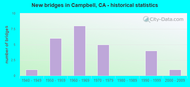
- New bridges - historical statistics
- 11940-1949
- 61950-1959
- 81960-1969
- 51970-1979
- 41990-1999
- 12000-2009

- Reconstructed bridges - Historical Statistics
- 21960-1969
- 11970-1979
- 11980-1989


- Bridge Condition - Deck
- 75.0%Good
- 16.7%Fair
- 8.3%Poor

- Bridge Condition - Superstructure
- 91.7%Good
- 8.3%Fair

- Bridge Condition - Substructure
- 91.7%Good
- 8.3%Fair

- Bridge Condition - Channel
- 66.7%Very good
- 11.1%Good
- 11.1%Satisfactory
- 11.1%Fair

- Bridge Condition - Culverts
- 66.7%Good
- 33.3%Satisfactory
Find on map >> Show street view
Structure Number: 37 0133, Location: 04-SCL-017-11.80-CMB (Lat: 37.287058, Lng: -121.936606), Route carried "on" structure: State highway 17, Year Built: 1959, Year Reconstructed: 1971, Status: Open, Structure Length: 4.08m (13.39ft), Average Daily Traffic: 151,200 (year 2017), Truck Traffic: 7%, Average Future Daily Traffic: 197,000 (year 2038), Design Load: HS 20, Features Intersected: CAMPBELL AVE
Minimum Vertical Clearance: 30+ m (98+ ft), Kilometerpoint: 11.800, Lanes on structure: 8, Lanes under structure: 4, Base Highway Network: Yes (, Subroute: 1), Owner: State Highway Agency, Approaching Roadway Width: 42.1m (138.1ft), Skew: 31 degrees, Material/Design: Steel, Design/Construction: Stringer/Multi-beam, Number Of Spans In Main Unit: 1, Number Of Approach Spans: 2, Length of Maximum Span: 20.1m (65.9ft), Curb-To-Curb Width: 41.6m (136.5ft), Out-to-Out Width: 42.9m (140.7ft)
Condition: Deck: Good, Superstructure: Good, Substructure: Good, Operating Rating: 36.9 metric tons, Method Used To Determine Operating Rating: Load and Resistance Factor Rating (LRFR) rating reported by rating factor(RF) method using HL-93 loadings, Inventory Rating: 28.5 metric tons, Method Used To Determine Inventory Rating: Load and Resistance Factor Rating (LRFR) rating reported by rating factor(RF) method using HL-93 loadings, Structural Evaluation: Better than present minimum criteria, Deck Geometry: Superior to present desirable criteria, Underclear: High priority of corrective action, Approach Roadway Alignment: Equal to present desirable criteria, Designated Inspection Frequency: Every 24 months, Inspection Date: July 2020, Deck Structure Type: Concrete Cast-file-Place
Find on map >> Show street view
Structure Number: 37 0134, Location: 04-SCL-017-12.03-CMB (Lat: 37.290186, Lng: -121.936256), Route carried "on" structure: State highway 17, Year Built: 1959, Year Reconstructed: 1971, Status: Open, Structure Length: 3.99m (13.09ft), Average Daily Traffic: 151,200 (year 2017), Truck Traffic: 7%, Average Future Daily Traffic: 197,000 (year 2038), Design Load: HS 20, Features Intersected: LOS GATOS CREEK
Minimum Vertical Clearance: 30+ m (98+ ft), Kilometerpoint: 12.030, Lanes on structure: 8, Base Highway Network: Yes (, Subroute: 1), Owner: State Highway Agency, Approaching Roadway Width: 44.8m (147.0ft), Skew: 31 degrees, Material/Design: Concrete continuous, Design/Construction: Tee Beam, Number Of Spans In Main Unit: 3, Length of Maximum Span: 15.2m (49.9ft), Curb-To-Curb Width: 44.5m (146.0ft), Out-to-Out Width: 45.8m (150.3ft)
Condition: Deck: Good, Superstructure: Good, Substructure: Good, Channel: Good, Operating Rating: 29.2 metric tons, Method Used To Determine Operating Rating: Load and Resistance Factor Rating (LRFR) rating reported by rating factor(RF) method using HL-93 loadings, Inventory Rating: 22.7 metric tons, Method Used To Determine Inventory Rating: Load and Resistance Factor Rating (LRFR) rating reported by rating factor(RF) method using HL-93 loadings, Structural Evaluation: Somewhat better than minimum adequacy, Deck Geometry: Superior to present desirable criteria, Waterway Adequacy: Superior to present desirable criteria, Approach Roadway Alignment: Equal to present desirable criteria, Designated Inspection Frequency: Every 24 months, Inspection Date: July 2020, Deck Structure Type: Concrete Cast-file-Place
Find on map >> Show street view
Structure Number: 37 0136, Location: 04-SCL-017-12.34-CMB (Lat: 37.294236, Lng: -121.938583), Route carried "on" structure: City street C199, Year Built: 1959, Year Reconstructed: 1991, Status: Open, Structure Length: 6.83m (22.41ft), Average Daily Traffic: 25,336 (year 2010), Truck Traffic: 2%, Average Future Daily Traffic: 33,000 (year 2038), Design Load: HS 20+Mod, Features Intersected: STATE ROUTE 17, Facility Carried by Structure: HAMILTON AVE
Minimum Vertical Clearance: 30+ m (98+ ft), Kilometerpoint: 0.000, Lanes on structure: 7, Lanes under structure: 8, Owner: State Highway Agency, Approaching Roadway Width: 25.7m (84.3ft), Skew: 22 degrees, Material/Design: Concrete continuous, Design/Construction: Box Beam or Girders - Multiple, Number Of Spans In Main Unit: 2, Number Of Approach Spans: 2, Length of Maximum Span: 22.6m (74.1ft), Curb or Sidewalk Widths: Left: 1.5m (4.9ft), Right: 1.5m (4.9ft), Curb-To-Curb Width: 25.7m (84.3ft), Out-to-Out Width: 30.9m (101.4ft)
Condition: Deck: Good, Superstructure: Good, Substructure: Good, Operating Rating: 53.8 metric tons, Method Used To Determine Operating Rating: Load Factor (LF), Inventory Rating: 32.1 metric tons, Method Used To Determine Inventory Rating: Load Factor (LF), Structural Evaluation: Better than present minimum criteria, Deck Geometry: Meets minimum limits, Underclear: High priority of corrective action, Approach Roadway Alignment: Equal to present desirable criteria, Designated Inspection Frequency: Every 48 months, Inspection Date: July 2020, Deck Structure Type: Concrete Cast-file-Place
Find on map >> Show street view
Structure Number: 37 0147, Location: 04-SCL-017-10.50-CMB (Lat: 37.270458, Lng: -121.947142), Route carried "on" structure: State highway 17, Year Built: 1971, Status: Open, Structure Length: 6.86m (22.51ft), Average Daily Traffic: 151,200 (year 2017), Truck Traffic: 7%, Average Future Daily Traffic: 197,000 (year 2038), Design Load: HS 20+Mod, Features Intersected: CAMDEN AVE
Minimum Vertical Clearance: 30+ m (98+ ft), Kilometerpoint: 10.500, Lanes on structure: 7, Lanes under structure: 9, Base Highway Network: Yes (, Subroute: 1), Owner: State Highway Agency, Approaching Roadway Width: 51.8m (169.9ft), Skew: 33 degrees, Material/Design: Steel continuous, Design/Construction: Box Beam or Girders - Multiple, Number Of Spans In Main Unit: 2, Length of Maximum Span: 36.3m (119.1ft), Curb-To-Curb Width: 46.0m (150.9ft), Out-to-Out Width: 49.7m (163.1ft)
Condition: Deck: Good, Superstructure: Good, Substructure: Good, Operating Rating: 58.0 metric tons, Method Used To Determine Operating Rating: Allowable Stress (AS), Inventory Rating: 30.8 metric tons, Method Used To Determine Inventory Rating: Allowable Stress (AS), Structural Evaluation: Better than present minimum criteria, Deck Geometry: Superior to present desirable criteria, Underclear: Meets minimum limits, Approach Roadway Alignment: Equal to present desirable criteria, Designated Inspection Frequency: Every 24 months, Inspection Date: July 2020, Deck Structure Type: Concrete Cast-file-Place
Find on map >> Show street view
Structure Number: 37C0053, Location: 0.01 MI N SH 17 (Lat: 37.272033, Lng: -121.949011), Route carried "on" structure: County highway , Year Built: 1968, Status: Open, Structure Length: 4.54m (14.90ft), Average Daily Traffic: 62,140 (year 2014), Truck Traffic: 7%, Average Future Daily Traffic: 77,469 (year 2044), Design Load: HS 20, Features Intersected: LOS GATOS CREEK, Facility Carried by Structure: SAN TOMAS EXPWY
Minimum Vertical Clearance: 30+ m (98+ ft), Kilometerpoint: 0.000, Lanes on structure: 9, Base Highway Network: Yes, Owner: County Highway Agency, Approaching Roadway Width: 35.4m (116.1ft), Skew: 31 degrees, Material/Design: Steel, Design/Construction: Stringer/Multi-beam, Number Of Spans In Main Unit: 3, Length of Maximum Span: 14.9m (48.9ft), Curb or Sidewalk Widths: Left: 1.2m (3.9ft), Right: 1.2m (3.9ft), Curb-To-Curb Width: 35.4m (116.1ft), Out-to-Out Width: 39.0m (128.0ft)
Condition: Deck: Good, Superstructure: Good, Substructure: Good, Channel: Very good, Operating Rating: 58.6 metric tons, Method Used To Determine Operating Rating: Load and Resistance Factor Rating (LRFR) rating reported by rating factor(RF) method using HL-93 loadings, Inventory Rating: 45.0 metric tons, Method Used To Determine Inventory Rating: Load and Resistance Factor Rating (LRFR) rating reported by rating factor(RF) method using HL-93 loadings, Structural Evaluation: Better than present minimum criteria, Deck Geometry: Somewhat better than minimum adequacy, Waterway Adequacy: Equal to present desirable criteria, Approach Roadway Alignment: Better than present minimum criteria, Designated Inspection Frequency: Every 48 months, Underwater Inspection Frequency: Every 60 months, Inspection Date: Febuary 2022, Underwater Inspection Date: Febuary 2021, Deck Structure Type: Concrete Cast-file-Place
Find on map >> Show street view
Structure Number: 37C0083, Location: AT WINCHESTER BLVD (Lat: 37.273750, Lng: -121.953206), Route carried "on" structure: County highway , Year Built: 1968, Status: Open, Structure Length: 9.36m (30.71ft), Average Daily Traffic: 62,140 (year 2014), Truck Traffic: 7%, Average Future Daily Traffic: 53,263 (year 2044), Design Load: HS 20, Features Intersected: WINCHESTER BLVD & UP RR, Facility Carried by Structure: SAN TOMAS EXPWY
Minimum Vertical Clearance: 30+ m (98+ ft), Kilometerpoint: 0.000, Lanes on structure: 6, Lanes under structure: 9, Owner: County Highway Agency, Approaching Roadway Width: 27.7m (90.9ft), Skew: 30 degrees, Material/Design: Steel, Design/Construction: Stringer/Multi-beam, Number Of Spans In Main Unit: 6, Length of Maximum Span: 18.2m (59.7ft), Curb-To-Curb Width: 25.8m (84.6ft), Out-to-Out Width: 28.9m (94.8ft)
Condition: Deck: Fair, Superstructure: Good, Substructure: Good, Operating Rating: 51.5 metric tons, Method Used To Determine Operating Rating: Allowable Stress (AS), Inventory Rating: 27.5 metric tons, Method Used To Determine Inventory Rating: Allowable Stress (AS), Structural Evaluation: Equal to present minimum criteria, Deck Geometry: Somewhat better than minimum adequacy, Underclear: High priority of corrective action, Approach Roadway Alignment: Better than present minimum criteria, Designated Inspection Frequency: Every 24 months, Inspection Date: Febuary 2022, Deck Structure Type: Concrete Cast-file-Place, Wearing Surface/Protective System: Wearing Surface: Bituminous
Find on map >> Show street view
Structure Number: 37C0083K, Location: AT WINCHESTER BLVD (Lat: 37.272350, Lng: -121.953633), Route carried "on" structure: County highway , Year Built: 1968, Status: Open, Structure Length: 14.95m (49.05ft), Average Daily Traffic: 6,500 (year 2015), Truck Traffic: 5%, Average Future Daily Traffic: 7,285 (year 2042), Features Intersected: UP RR, DELL AVE, Facility Carried by Structure: SAN TOMAS EXPWY
Minimum Vertical Clearance: 30+ m (98+ ft), Kilometerpoint: 0.000, Lanes on structure: 1, Lanes under structure: 2, Owner: County Highway Agency, Approaching Roadway Width: 6.7m (22.0ft), Material/Design: Steel, Design/Construction: Stringer/Multi-beam, Number Of Spans In Main Unit: 7, Length of Maximum Span: 20.7m (67.9ft), Curb-To-Curb Width: 6.7m (22.0ft), Out-to-Out Width: 7.9m (25.9ft)
Condition: Deck: Poor, Superstructure: Fair, Substructure: Good, Operating Rating: 41.5 metric tons, Method Used To Determine Operating Rating: Load Factor (LF), Inventory Rating: 24.9 metric tons, Method Used To Determine Inventory Rating: Load Factor (LF), Structural Evaluation: Somewhat better than minimum adequacy, Deck Geometry: High priority of replacement, Underclear: Meets minimum limits, Approach Roadway Alignment: Better than present minimum criteria, Length Of Structure Improvement: 14.79m (48.52ft), Designated Inspection Frequency: Every 24 months, Critical Feature Inspection Frequency: Every 24 months, Inspection Date: Febuary 2022, Critical Feature Inspection Date: July 2020, Bridge Improvement Cost: $1,170,000, Roadway Improvement Cost: $234,000, Total Project Cost: $1,965,000 ( Estimate for 2019), Deck Structure Type: Concrete Cast-file-Place
Find on map >> Show street view
Structure Number: 37C0083S, Location: WINCHESTER BLVD (Lat: 37.273781, Lng: -121.951956), Route carried "on" structure: Ramp County highway , Year Built: 1968, Status: Open, Structure Length: 16.66m (54.66ft), Average Daily Traffic: 9,500 (year 2010), Truck Traffic: 5%, Average Future Daily Traffic: 11,448 (year 2042), Features Intersected: UP RR, DELL AVE, Facility Carried by Structure: SAN TOMAS EXPWY
Minimum Vertical Clearance: 30+ m (98+ ft), Kilometerpoint: 0.000, Lanes on structure: 1, Lanes under structure: 2, Owner: County Highway Agency, Approaching Roadway Width: 6.7m (22.0ft), Material/Design: Steel, Design/Construction: Stringer/Multi-beam, Number Of Spans In Main Unit: 9, Length of Maximum Span: 20.9m (68.6ft), Curb-To-Curb Width: 6.7m (22.0ft), Out-to-Out Width: 7.9m (25.9ft)
Condition: Deck: Fair, Superstructure: Good, Substructure: Good, Operating Rating: 40.5 metric tons, Method Used To Determine Operating Rating: Load Factor (LF), Inventory Rating: 24.3 metric tons, Method Used To Determine Inventory Rating: Load Factor (LF), Structural Evaluation: Equal to present minimum criteria, Deck Geometry: Equal to present minimum criteria, Underclear: High priority of corrective action, Approach Roadway Alignment: Better than present minimum criteria, Designated Inspection Frequency: Every 24 months, Critical Feature Inspection Frequency: Every 24 months, Inspection Date: Febuary 2022, Critical Feature Inspection Date: July 2020, Deck Structure Type: Concrete Cast-file-Place
Find on map >> Show street view
Structure Number: 37C0108, Location: AT SAN TOMAS AQUINO CR (Lat: 37.286836, Lng: -121.961106), Route carried "on" structure: City street , Year Built: 1966, Status: Open, Structure Length: 1.13m (3.71ft), Average Daily Traffic: 2,750 (year 2013), Truck Traffic: 5%, Average Future Daily Traffic: 3,164 (year 2044), Design Load: HS 20, Features Intersected: SAN TOMAS AQUINO CREEK, Facility Carried by Structure: CAMPBELL AVE
Minimum Vertical Clearance: 30+ m (98+ ft), Kilometerpoint: 0.000, Lanes on structure: 7, Owner: City or Municipal Highway Agency, Approaching Roadway Width: 30.8m (101.0ft), Skew: 20 degrees, Material/Design: Prestressed concrete, Design/Construction: Slab, Number Of Spans In Main Unit: 1, Length of Maximum Span: 10.8m (35.4ft), Curb or Sidewalk Widths: Left: 7.0m (23.0ft), Right: 5.2m (17.1ft), Curb-To-Curb Width: 30.9m (101.4ft), Out-to-Out Width: 43.1m (141.4ft)
Condition: Deck: Good, Superstructure: Good, Substructure: Good, Channel: Very good, Operating Rating: 99.1 metric tons, Method Used To Determine Operating Rating: Load Factor (LF), Inventory Rating: 32.4 metric tons, Method Used To Determine Inventory Rating: Load Factor (LF), Structural Evaluation: Better than present minimum criteria, Deck Geometry: Better than present minimum criteria, Waterway Adequacy: Better than present minimum criteria, Approach Roadway Alignment: Equal to present desirable criteria, Designated Inspection Frequency: Every 48 months, Inspection Date: Febuary 2022, Deck Structure Type: Concrete Precast Panels, Wearing Surface/Protective System: Wearing Surface: Bituminous
Find on map >> Show street view
Structure Number: 37C0136, Location: AT SAN TOMAS EXPWY (Lat: 37.294008, Lng: -121.961150), Route carried "on" structure: City street , Year Built: 1966, Status: Open, Structure Length: 1.13m (3.71ft), Average Daily Traffic: 3,000 (year 2009), Truck Traffic: 5%, Average Future Daily Traffic: 4,219 (year 2044), Design Load: HS 20, Features Intersected: SAN TOMAS AQUINO CREEK, Facility Carried by Structure: HAMILTON AVE
Minimum Vertical Clearance: 30+ m (98+ ft), Kilometerpoint: 0.000, Lanes on structure: 4, Base Highway Network: Yes, Owner: City or Municipal Highway Agency, Approaching Roadway Width: 41.7m (136.8ft), Skew: 20 degrees, Material/Design: Prestressed concrete, Design/Construction: Slab, Number Of Spans In Main Unit: 1, Length of Maximum Span: 10.7m (35.1ft), Curb or Sidewalk Widths: Left: 5.0m (16.4ft), Right: 5.0m (16.4ft), Curb-To-Curb Width: 41.7m (136.8ft), Out-to-Out Width: 51.7m (169.6ft)
Condition: Deck: Good, Superstructure: Good, Substructure: Good, Channel: Very good, Operating Rating: 99.8 metric tons, Method Used To Determine Operating Rating: Load Factor (LF), Inventory Rating: 32.4 metric tons, Method Used To Determine Inventory Rating: Load Factor (LF), Structural Evaluation: Better than present minimum criteria, Deck Geometry: Superior to present desirable criteria, Waterway Adequacy: Better than present minimum criteria, Approach Roadway Alignment: Equal to present desirable criteria, Designated Inspection Frequency: Every 48 months, Inspection Date: Febuary 2022, Deck Structure Type: Concrete Precast Panels, Wearing Surface/Protective System: Wearing Surface: Bituminous
Find on map >> Show street view
Structure Number: 37C0149, Location: NEAR SH 17 (Lat: 37.286997, Lng: -121.938358), Route carried "on" structure: City street , Year Built: 1940, Status: Open, Structure Length: 1.68m (5.51ft), Average Daily Traffic: 23,509 (year 2013), Truck Traffic: 2%, Average Future Daily Traffic: 30,662 (year 2039), Design Load: H 15, Features Intersected: LOS GATOS CREEK, Facility Carried by Structure: CAMPBELL AVE
Minimum Vertical Clearance: 30+ m (98+ ft), Kilometerpoint: 0.000, Lanes on structure: 4, Owner: City or Municipal Highway Agency, Approaching Roadway Width: 16.5m (54.1ft), Skew: 22 degrees, Material/Design: Concrete, Design/Construction: Tee Beam, Number Of Spans In Main Unit: 1, Length of Maximum Span: 15.2m (49.9ft), Curb or Sidewalk Widths: Left: 1.5m (4.9ft), Right: 1.5m (4.9ft), Curb-To-Curb Width: 16.5m (54.1ft), Out-to-Out Width: 20.1m (65.9ft)
Condition: Deck: Good, Superstructure: Good, Substructure: Fair, Channel: Fair, Operating Rating: 53.5 metric tons, Method Used To Determine Operating Rating: Allowable Stress (AS), Inventory Rating: 32.6 metric tons, Method Used To Determine Inventory Rating: Allowable Stress (AS), Structural Evaluation: Somewhat better than minimum adequacy, Deck Geometry: Meets minimum limits, Waterway Adequacy: Better than present minimum criteria, Approach Roadway Alignment: Better than present minimum criteria, Designated Inspection Frequency: Every 24 months, Inspection Date: May 2020, Deck Structure Type: Concrete Cast-file-Place, Wearing Surface/Protective System: Wearing Surface: Bituminous
Find on map >> Show street view
Structure Number: 37C0157, Location: NEAR BASCOM AVE (Lat: 37.294153, Lng: -121.933258), Route carried "on" structure: City street , Year Built: 1960, Year Reconstructed: 1982, Status: Open, Structure Length: 3.79m (12.43ft), Average Daily Traffic: 56,709 (year 2011), Truck Traffic: 8%, Average Future Daily Traffic: 109,045 (year 2039), Design Load: HS 20, Features Intersected: LOS GATOS CREEK, Facility Carried by Structure: HAMILTON AVE
Minimum Vertical Clearance: 30+ m (98+ ft), Kilometerpoint: 0.000, Lanes on structure: 9, Base Highway Network: Yes, Owner: City or Municipal Highway Agency, Approaching Roadway Width: 31.4m (103.0ft), Skew: 21 degrees, Material/Design: Prestressed concrete, Design/Construction: Stringer/Multi-beam, Number Of Spans In Main Unit: 1, Length of Maximum Span: 36.6m (120.1ft), Curb or Sidewalk Widths: Left: 1.5m (4.9ft), Right: 1.5m (4.9ft), Curb-To-Curb Width: 31.4m (103.0ft), Out-to-Out Width: 35.1m (115.2ft)
Condition: Deck: Good, Superstructure: Good, Substructure: Good, Channel: Satisfactory, Operating Rating: 38.9 metric tons, Method Used To Determine Operating Rating: Load and Resistance Factor Rating (LRFR) rating reported by rating factor(RF) method using HL-93 loadings, Inventory Rating: 21.1 metric tons, Method Used To Determine Inventory Rating: Load and Resistance Factor Rating (LRFR) rating reported by rating factor(RF) method using HL-93 loadings, Structural Evaluation: Somewhat better than minimum adequacy, Deck Geometry: High priority of replacement, Waterway Adequacy: Equal to present minimum criteria, Approach Roadway Alignment: Equal to present desirable criteria, Designated Inspection Frequency: Every 24 months, Inspection Date: May 2020, Deck Structure Type: Concrete Cast-file-Place, Wearing Surface/Protective System: Wearing Surface: Bituminous
Find on map >> Show street view
Structure Number: 37C0282, Location: BUDD AVE (Lat: 37.279406, Lng: -121.963308), Route carried "on" structure: City street , Year Built: 1970, Status: Open, Structure Length: 0.94m (3.08ft), Average Daily Traffic: 2,704 (year 2011), Truck Traffic: 2%, Average Future Daily Traffic: 3,750 (year 2037), Features Intersected: SAN TOMAS AQUINO CREEK, Facility Carried by Structure: VIRGINIA AVE
Minimum Vertical Clearance: 30+ m (98+ ft), Kilometerpoint: 0.000, Lanes on structure: 2, Owner: City or Municipal Highway Agency, Approaching Roadway Width: 14.0m (45.9ft), Skew: 4 degrees, Material/Design: Concrete continuous, Design/Construction: Culvert, Number Of Spans In Main Unit: 2, Length of Maximum Span: 4.1m (13.5ft), Curb or Sidewalk Widths: Left: 2.1m (6.9ft), Right: 2.0m (6.6ft), Curb-To-Curb Width: 14.2m (46.6ft), Out-to-Out Width: 18.9m (62.0ft)
Condition: Channel: Very good, Culverts: Good, Operating Rating: 40.5 metric tons, Method Used To Determine Operating Rating: Field evaluation and documented engineering judgment, Inventory Rating: 24.3 metric tons, Method Used To Determine Inventory Rating: Field evaluation and documented engineering judgment, Structural Evaluation: Equal to present minimum criteria, Deck Geometry: Superior to present desirable criteria, Waterway Adequacy: Better than present minimum criteria, Approach Roadway Alignment: Better than present minimum criteria, Designated Inspection Frequency: Every 24 months, Inspection Date: May 2020
Find on map >> Show street view
Structure Number: 37C0283, Location: FENIAN DR (Lat: 37.277331, Lng: -121.976625), Route carried "on" structure: City street , Year Built: 1974, Status: Open, Structure Length: 0.79m (2.59ft), Average Daily Traffic: 7,000 (year 2010), Truck Traffic: 8%, Average Future Daily Traffic: 8,724 (year 2036), Features Intersected: SAN TOMAS AQUINO CREEK, Facility Carried by Structure: HARRIET AVE
Minimum Vertical Clearance: 30+ m (98+ ft), Kilometerpoint: 0.000, Lanes on structure: 3, Owner: City or Municipal Highway Agency, Approaching Roadway Width: 20.4m (66.9ft), Skew: 2 degrees, Material/Design: Concrete continuous, Design/Construction: Culvert, Number Of Spans In Main Unit: 2, Length of Maximum Span: 3.8m (12.5ft), Curb or Sidewalk Widths: Left: 1.9m (6.2ft), Right: 0.6m (2.0ft), Curb-To-Curb Width: 15.2m (49.9ft), Out-to-Out Width: 18.3m (60.0ft)
Condition: Channel: Very good, Culverts: Good, Operating Rating: 54.1 metric tons, Method Used To Determine Operating Rating: Field evaluation and documented engineering judgment, Inventory Rating: 32.4 metric tons, Method Used To Determine Inventory Rating: Field evaluation and documented engineering judgment, Structural Evaluation: Better than present minimum criteria, Deck Geometry: Equal to present minimum criteria, Waterway Adequacy: Better than present minimum criteria, Approach Roadway Alignment: Equal to present desirable criteria, Designated Inspection Frequency: Every 48 months, Inspection Date: May 2018
Find on map >> Show street view
Structure Number: 37C0284, Location: NEAR HARRIET AVE (Lat: 37.276511, Lng: -121.977625), Route carried "on" structure: City street , Year Built: 1970, Status: Open, Structure Length: 0.78m (2.56ft), Average Daily Traffic: 5,009 (year 2011), Truck Traffic: 2%, Average Future Daily Traffic: 7,525 (year 2037), Features Intersected: SAN TOMAS AQUINO CREEK, Facility Carried by Structure: MCCOY AVE
Minimum Vertical Clearance: 30+ m (98+ ft), Kilometerpoint: 0.000, Lanes on structure: 2, Owner: City or Municipal Highway Agency, Approaching Roadway Width: 12.2m (40.0ft), Skew: 2 degrees, Material/Design: Concrete continuous, Design/Construction: Culvert, Number Of Spans In Main Unit: 2, Length of Maximum Span: 3.4m (11.2ft), Curb or Sidewalk Widths: Left: 0.3m (1.0ft), Right: 1.7m (5.6ft), Curb-To-Curb Width: 8.6m (28.2ft), Out-to-Out Width: 11.2m (36.7ft)
Condition: Channel: Very good, Culverts: Satisfactory, Operating Rating: 40.5 metric tons, Method Used To Determine Operating Rating: Field evaluation and documented engineering judgment, Inventory Rating: 24.3 metric tons, Method Used To Determine Inventory Rating: Field evaluation and documented engineering judgment, Structural Evaluation: Equal to present minimum criteria, Deck Geometry: High priority of replacement, Waterway Adequacy: Better than present minimum criteria, Approach Roadway Alignment: Better than present minimum criteria, Designated Inspection Frequency: Every 24 months, Inspection Date: May 2020
Find on map >> Show street view
Structure Number: 37 0133, Location: 04-SCL-017-11.80-CMB (Lat: 37.287058, Lng: -121.936606), Route carried "under" structure: City street C031, Year Built: 1959, Structure Length: 0. m, Average Daily Traffic: 23,509 (year 2013), Truck Traffic: 1%, Features Intersected: CAMPBELL AVE, Facility Carried by Structure: STATE ROUTE 17
Minimum Vertical Clearance: 4.70m (15.42ft), Kilometerpoint: 0.000, Lanes on structure: 8, Lanes under structure: 4, Material/Design: Steel, Design/Construction: Stringer/Multi-beam, Length of Maximum Span: 20.1m (65.9ft)
Find on map >> Show street view
Structure Number: 37 0135, Location: 04-SCL-017-12.22-CMB (Lat: 37.292514, Lng: -121.937792), Route carried "under" structure: State highway 17, Year Built: 1959, Structure Length: 0. m, Average Daily Traffic: 151,200 (year 2017), Truck Traffic: 7%, Features Intersected: STATE ROUTE 17, Facility Carried by Structure: UP RR
Minimum Vertical Clearance: 4.64m (15.22ft), Kilometerpoint: 12.220, Lanes under structure: 8, Material/Design: Steel, Design/Construction: Girder and Floorbeam System, Length of Maximum Span: 25.0m (82.0ft)
Find on map >> Show street view
Structure Number: 37 0136, Location: 04-SCL-017-12.34-CMB (Lat: 37.294236, Lng: -121.938583), Route carried "under" structure: State highway 17, Year Built: 1959, Structure Length: 0. m, Average Daily Traffic: 184,800 (year 2017), Truck Traffic: 4%, Features Intersected: STATE ROUTE 17, Facility Carried by Structure: HAMILTON AVE
Minimum Vertical Clearance: 4.59m (15.06ft), Kilometerpoint: 12.340, Lanes on structure: 7, Lanes under structure: 8, Material/Design: Concrete continuous, Design/Construction: Box Beam or Girders - Multiple, Length of Maximum Span: 22.6m (74.1ft)
Find on map >> Show street view
Structure Number: 37 0147, Location: 04-SCL-017-10.50-CMB (Lat: 37.270458, Lng: -121.947142), Route carried "under" structure: City street , Year Built: 1971, Structure Length: 0. m, Average Daily Traffic: 62,140 (year 2014), Truck Traffic: 7%, Features Intersected: CAMDEN AVE, Facility Carried by Structure: STATE ROUTE 17
Minimum Vertical Clearance: 4.80m (15.75ft), Kilometerpoint: 0.000, Lanes on structure: 7, Lanes under structure: 9, Material/Design: Steel continuous, Design/Construction: Box Beam or Girders - Multiple, Length of Maximum Span: 36.3m (119.1ft)
Find on map >> Show street view
Structure Number: 37 0535, Location: 04-SCL-017-9.60 (Lat: 37.259675, Lng: -121.953694), Route carried "under" structure: Ramp State highway 85, Year Built: 1996, Structure Length: 0. m, Average Daily Traffic: 20,400 (year 2013), Truck Traffic: 2%, Features Intersected: SR 17, S17-N&S85 CONNS, Facility Carried by Structure: PEDESTRIAN WALKWAY
Minimum Vertical Clearance: 5.80m (19.03ft), Kilometerpoint: 10.480, Lanes under structure: 1, Material/Design: Concrete continuous, Design/Construction: Box Beam or Girders - Multiple, Length of Maximum Span: 42.2m (138.5ft)
Find on map >> Show street view
Structure Number: 37 0535, Location: 04-SCL-017-9.60 (Lat: 37.259675, Lng: -121.953694), Route carried "under" structure: Ramp State highway 17, Year Built: 1996, Structure Length: 0. m, Average Daily Traffic: 14,000 (year 2010), Truck Traffic: 5%, Features Intersected: SR 17, S17-N&S85 CONNS, Facility Carried by Structure: PEDESTRIAN WALKWAY
Minimum Vertical Clearance: 5.89m (19.32ft), Kilometerpoint: 9.800, Lanes under structure: 2, Material/Design: Concrete continuous, Design/Construction: Box Beam or Girders - Multiple, Length of Maximum Span: 42.2m (138.5ft)
Find on map >> Show street view
Structure Number: 37 0535, Location: 04-SCL-017-9.60 (Lat: 37.259675, Lng: -121.953694), Route carried "under" structure: State highway 17, Year Built: 1996, Structure Length: 0. m, Average Daily Traffic: 139,700 (year 2017), Truck Traffic: 7%, Features Intersected: SR 17, S17-N&S85 CONNS, Facility Carried by Structure: PEDESTRIAN WALKWAY
Minimum Vertical Clearance: 5.80m (19.03ft), Kilometerpoint: 9.600, Lanes under structure: 6, Material/Design: Concrete continuous, Design/Construction: Box Beam or Girders - Multiple, Length of Maximum Span: 42.2m (138.5ft)
Find on map >> Show street view
Structure Number: 37 0535, Location: 04-SCL-017-9.60 (Lat: 37.259675, Lng: -121.953694), Route carried "under" structure: Ramp State highway 17, Year Built: 1996, Structure Length: 0. m, Average Daily Traffic: 15,100 (year 2013), Truck Traffic: 5%, Features Intersected: SR 17, S17-N&S85 CONNS, Facility Carried by Structure: PEDESTRIAN WALKWAY
Minimum Vertical Clearance: 5.89m (19.32ft), Kilometerpoint: 9.810, Lanes under structure: 1, Material/Design: Concrete continuous, Design/Construction: Box Beam or Girders - Multiple, Length of Maximum Span: 42.2m (138.5ft)
Find on map >> Show street view
Structure Number: 37 0603, Location: 04-SCL-017-12.23-CMB (Lat: 37.292556, Lng: -121.937889), Route carried "under" structure: State highway 17, Year Built: 2004, Structure Length: 0. m, Average Daily Traffic: 151,200 (year 2017), Truck Traffic: 7%, Features Intersected: STATE ROUTE 17, Facility Carried by Structure: VTA LRT (2 TRACKS)
Minimum Vertical Clearance: 5.48m (17.98ft), Kilometerpoint: 12.230, Lanes under structure: 8, Material/Design: Prestressed concrete, Design/Construction: Box Beam or Girders - Multiple, Length of Maximum Span: 38.0m (124.7ft)
Find on map >> Show street view
Structure Number: 37C0083, Location: AT WINCHESTER BLVD (Lat: 37.273750, Lng: -121.953206), Route carried "under" structure: City street , Year Built: 1968, Structure Length: 0. m, Average Daily Traffic: 10,000 (year 2010), Truck Traffic: 1%, Features Intersected: WINCHESTER BLVD & UP RR, Facility Carried by Structure: SAN TOMAS EXPWY
Minimum Vertical Clearance: 6.71m (22.01ft), Kilometerpoint: 0.000, Lanes on structure: 6, Lanes under structure: 7, Material/Design: Steel, Design/Construction: Stringer/Multi-beam, Length of Maximum Span: 18.2m (59.7ft)