Bridge Statistics for Calimesa, California (CA)
Condition, Traffic, Stress, Structural Evaluation, Project Costs
- National Bridge Inventory (NBI) Statistics
- 16Number of bridges
- 131ft / 39.9mTotal length
- 622,694Total average daily traffic
- 75,095Total average daily truck traffic
- National Bridge Inventory (NBI) Registered Bridges for Calimesa
- No street view available for this location
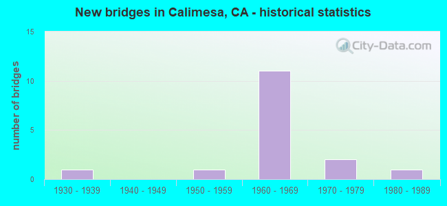
- New bridges - historical statistics
- 11930-1939
- 11950-1959
- 111960-1969
- 21970-1979
- 11980-1989

- Reconstructed bridges - Historical Statistics
- 11960-1969
- 01970-1979
- 01980-1989
- 01990-1999
- 22000-2009


- Bridge Condition - Deck
- 87.5%Good
- 12.5%Fair

- Bridge Condition - Substructure
- 62.5%Good
- 37.5%Fair

- Bridge Condition - Channel
- 14.3%Excellent
- 42.9%Very good
- 42.9%Good

- Bridge Condition - Culverts
- 33.3%Good
- 66.7%Satisfactory
Find on map >> Show street view
Structure Number: 56 0212L, Location: 08-RIV-010-R78.54 (Lat: 33.663275, Lng: -115.854056), Route carried "on" structure: Interstate 10, Year Built: 1965, Status: Open, Structure Length: 3.36m (11.02ft), Average Daily Traffic: 11,250 (year 2012), Truck Traffic: 39%, Average Future Daily Traffic: 20,430 (year 2044), Design Load: HS 20, Features Intersected: BURIED MOUNTAIN WASH
Minimum Vertical Clearance: 30+ m (98+ ft), Kilometerpoint: 78.540, Lanes on structure: 2, Base Highway Network: Yes (, Subroute: 1), Owner: State Highway Agency, Approaching Roadway Width: 12.1m (39.7ft), Skew: 3 degrees, Material/Design: Concrete continuous, Design/Construction: Slab, Number Of Spans In Main Unit: 6, Length of Maximum Span: 5.5m (18.0ft), Curb-To-Curb Width: 12.1m (39.7ft), Out-to-Out Width: 12.7m (41.7ft)
Condition: Deck: Good, Superstructure: Good, Substructure: Fair, Channel: Very good, Operating Rating: 47.6 metric tons, Method Used To Determine Operating Rating: Load Factor (LF), Inventory Rating: 28.5 metric tons, Method Used To Determine Inventory Rating: Load Factor (LF), Structural Evaluation: Somewhat better than minimum adequacy, Deck Geometry: Equal to present minimum criteria, Waterway Adequacy: Equal to present desirable criteria, Approach Roadway Alignment: Equal to present desirable criteria, Designated Inspection Frequency: Every 24 months, Inspection Date: Febuary 2022, Deck Structure Type: Concrete Cast-file-Place, Wearing Surface/Protective System: Wearing Surface: Bituminous
Find on map >> Show street view
Structure Number: 56 0215, Location: 08-RIV-010-R5.71-CMSA (Lat: 33.942739, Lng: -117.001553), Route carried "on" structure: Interstate 10, Year Built: 1951, Year Reconstructed: 2011, Status: Open, Structure Length: 3.12m (10.24ft), Average Daily Traffic: 44,500 (year 2012), Average Future Daily Traffic: 74,650 (year 2040), Design Load: HL 93, Features Intersected: MID FK SAN TIMOTEO CREEK
Minimum Vertical Clearance: 30+ m (98+ ft), Kilometerpoint: 5.710, Lanes on structure: 8, Base Highway Network: Yes (, Subroute: 1), Owner: State Highway Agency, Approaching Roadway Width: 45.1m (148.0ft), Skew: 32 degrees, Material/Design: Concrete continuous, Design/Construction: Slab, Number Of Spans In Main Unit: 5, Length of Maximum Span: 6.7m (22.0ft), Curb-To-Curb Width: 45.1m (148.0ft), Out-to-Out Width: 46.0m (150.9ft)
Condition: Deck: Good, Superstructure: Good, Substructure: Good, Channel: Good, Operating Rating: 42.1 metric tons, Method Used To Determine Operating Rating: Assigned ratings based on Load and Resistance Factor Design (LRFD) reported by rating factor (RF) using HL93 loadings, Inventory Rating: 32.4 metric tons, Method Used To Determine Inventory Rating: Assigned ratings based on Load and Resistance Factor Design (LRFD) reported by rating factor (RF) using HL93 loadings, Structural Evaluation: Better than present minimum criteria, Deck Geometry: Superior to present desirable criteria, Waterway Adequacy: Better than present minimum criteria, Approach Roadway Alignment: Equal to present desirable criteria, Designated Inspection Frequency: Every 24 months, Inspection Date: March 2021, Deck Structure Type: Concrete Cast-file-Place
Find on map >> Show street view
Structure Number: 56 037, Location: 08-RIV-010-R2.81-CMSA (Lat: 33.970578, Lng: -117.039089), Route carried "on" structure: Interstate 10, Year Built: 1937, Year Reconstructed: 1965, Status: Open, Structure Length: 1.16m (3.81ft), Average Daily Traffic: 98,000 (year 2012), Truck Traffic: 13%, Average Future Daily Traffic: 150,600 (year 2040), Features Intersected: EL CASCO CREEK
Minimum Vertical Clearance: 30+ m (98+ ft), Kilometerpoint: 2.810, Lanes on structure: 7, Base Highway Network: Yes (, Subroute: 1), Owner: State Highway Agency, Approaching Roadway Width: 37.2m (122.0ft), Skew: 6 degrees, Material/Design: Concrete continuous, Design/Construction: Culvert, Number Of Spans In Main Unit: 2, Length of Maximum Span: 5.5m (18.0ft)
Condition: Channel: Good, Culverts: Satisfactory, Operating Rating: 40.5 metric tons, Method Used To Determine Operating Rating: Field evaluation and documented engineering judgment, Inventory Rating: 24.3 metric tons, Method Used To Determine Inventory Rating: Field evaluation and documented engineering judgment, Structural Evaluation: Equal to present minimum criteria, Waterway Adequacy: Better than present minimum criteria, Approach Roadway Alignment: Equal to present desirable criteria, Designated Inspection Frequency: Every 24 months, Inspection Date: March 2021
Find on map >> Show street view
Structure Number: 56 0481, Location: 08-RIV-010-R3.05 (Lat: 33.968381, Lng: -117.035403), Route carried "on" structure: County highway W553, Year Built: 1965, Status: Open, Structure Length: 8.32m (27.30ft), Average Daily Traffic: 1,400 (year 2012), Truck Traffic: 2%, Average Future Daily Traffic: 1,462 (year 2040), Design Load: HS 20, Features Intersected: INTERSTATE 10, Facility Carried by Structure: CHERRY VALLEY BLVD
Minimum Vertical Clearance: 30+ m (98+ ft), Kilometerpoint: 0.000, Lanes on structure: 2, Lanes under structure: 6, Owner: State Highway Agency, Approaching Roadway Width: 12.2m (40.0ft), Skew: 3 degrees, Material/Design: Prestressed concrete, Design/Construction: Stringer/Multi-beam, Number Of Spans In Main Unit: 2, Number Of Approach Spans: 2, Length of Maximum Span: 28.7m (94.2ft), Curb or Sidewalk Widths: Left: 0.0m, Right: 1.5m (4.9ft), Curb-To-Curb Width: 12.2m (40.0ft), Out-to-Out Width: 14.3m (46.9ft)
Condition: Deck: Good, Superstructure: Good, Substructure: Good, Operating Rating: 29.8 metric tons, Method Used To Determine Operating Rating: Load and Resistance Factor Rating (LRFR) rating reported by rating factor(RF) method using HL-93 loadings, Inventory Rating: 21.4 metric tons, Method Used To Determine Inventory Rating: Load and Resistance Factor Rating (LRFR) rating reported by rating factor(RF) method using HL-93 loadings, Structural Evaluation: Somewhat better than minimum adequacy, Deck Geometry: Better than present minimum criteria, Underclear: Equal to present minimum criteria, Approach Roadway Alignment: Equal to present desirable criteria, Designated Inspection Frequency: Every 24 months, Inspection Date: March 2021, Deck Structure Type: Concrete Cast-file-Place, Wearing Surface/Protective System: Wearing Surface: Bituminous
Find on map >> Show street view
Structure Number: 56 0482, Location: 08-RIV-010-R1.92-CMSA (Lat: 33.979142, Lng: -117.049708), Route carried "on" structure: County highway R015, Year Built: 1965, Status: Open, Structure Length: 7.31m (23.98ft), Average Daily Traffic: 700 (year 2012), Truck Traffic: 2%, Average Future Daily Traffic: 720 (year 2040), Design Load: HS 20, Features Intersected: INTERSTATE 10, Facility Carried by Structure: SINGLETON ROAD
Minimum Vertical Clearance: 30+ m (98+ ft), Kilometerpoint: 0.000, Lanes on structure: 2, Lanes under structure: 6, Owner: State Highway Agency, Approaching Roadway Width: 9.8m (32.2ft), Skew: 1 degrees, Material/Design: Prestressed concrete, Design/Construction: Stringer/Multi-beam, Number Of Spans In Main Unit: 2, Number Of Approach Spans: 2, Length of Maximum Span: 25.3m (83.0ft), Curb or Sidewalk Widths: Left: 1.5m (4.9ft), Right: 0.0m, Curb-To-Curb Width: 9.8m (32.2ft), Out-to-Out Width: 12.0m (39.4ft)
Condition: Deck: Good, Superstructure: Good, Substructure: Good, Operating Rating: 70.0 metric tons, Method Used To Determine Operating Rating: Load Factor (LF), Inventory Rating: 32.4 metric tons, Method Used To Determine Inventory Rating: Load Factor (LF), Structural Evaluation: Better than present minimum criteria, Deck Geometry: Equal to present minimum criteria, Underclear: Equal to present minimum criteria, Approach Roadway Alignment: Equal to present desirable criteria, Designated Inspection Frequency: Every 24 months, Inspection Date: March 2021, Deck Structure Type: Concrete Cast-file-Place, Wearing Surface/Protective System: Wearing Surface: Bituminous
Find on map >> Show street view
Structure Number: 56 0483, Location: 08-RIV-010-R0.86 (Lat: 33.992975, Lng: -117.057942), Route carried "on" structure: County highway , Year Built: 1965, Status: Open, Structure Length: 7.33m (24.05ft), Average Daily Traffic: 2,800 (year 2012), Truck Traffic: 2%, Average Future Daily Traffic: 2,875 (year 2040), Design Load: HS 20, Features Intersected: INTERSTATE 10, Facility Carried by Structure: SANDALWOOD DRIVE
Minimum Vertical Clearance: 30+ m (98+ ft), Kilometerpoint: 0.000, Lanes on structure: 2, Lanes under structure: 6, Owner: State Highway Agency, Approaching Roadway Width: 12.2m (40.0ft), Material/Design: Prestressed concrete, Design/Construction: Stringer/Multi-beam, Number Of Spans In Main Unit: 2, Number Of Approach Spans: 2, Length of Maximum Span: 24.2m (79.4ft), Curb or Sidewalk Widths: Left: 0.0m, Right: 1.5m (4.9ft), Curb-To-Curb Width: 12.2m (40.0ft), Out-to-Out Width: 14.4m (47.2ft)
Condition: Deck: Good, Superstructure: Good, Substructure: Good, Operating Rating: 37.6 metric tons, Method Used To Determine Operating Rating: Load and Resistance Factor Rating (LRFR) rating reported by rating factor(RF) method using HL-93 loadings, Inventory Rating: 29.2 metric tons, Method Used To Determine Inventory Rating: Load and Resistance Factor Rating (LRFR) rating reported by rating factor(RF) method using HL-93 loadings, Structural Evaluation: Better than present minimum criteria, Deck Geometry: Equal to present minimum criteria, Underclear: Equal to present minimum criteria, Approach Roadway Alignment: Equal to present desirable criteria, Designated Inspection Frequency: Every 24 months, Inspection Date: March 2021, Deck Structure Type: Concrete Cast-file-Place, Wearing Surface/Protective System: Wearing Surface: Bituminous
Find on map >> Show street view
Structure Number: 56 0484, Location: 08-RIV-010-R0.02-CMSA (Lat: 34.003683, Lng: -117.065094), Route carried "on" structure: Interstate 10, Year Built: 1965, Year Reconstructed: 2011, Status: Open, Structure Length: 3.69m (12.11ft), Average Daily Traffic: 51,500 (year 2012), Truck Traffic: 13%, Average Future Daily Traffic: 77,050 (year 2040), Design Load: HS 20, Features Intersected: COUNTY LINE ROAD
Minimum Vertical Clearance: 30+ m (98+ ft), Kilometerpoint: 0.020, Lanes on structure: 6, Lanes under structure: 3, Base Highway Network: Yes (, Subroute: 1), Owner: State Highway Agency, Approaching Roadway Width: 48.4m (158.8ft), Skew: 30 degrees, Material/Design: Prestressed concrete, Design/Construction: Stringer/Multi-beam, Number Of Spans In Main Unit: 3, Length of Maximum Span: 19.2m (63.0ft), Curb-To-Curb Width: 48.4m (158.8ft), Out-to-Out Width: 53.0m (173.9ft)
Condition: Deck: Good, Superstructure: Good, Substructure: Fair, Operating Rating: 34.0 metric tons, Method Used To Determine Operating Rating: Load and Resistance Factor Rating (LRFR) rating reported by rating factor(RF) method using HL-93 loadings, Inventory Rating: 26.2 metric tons, Method Used To Determine Inventory Rating: Load and Resistance Factor Rating (LRFR) rating reported by rating factor(RF) method using HL-93 loadings, Structural Evaluation: Somewhat better than minimum adequacy, Deck Geometry: Superior to present desirable criteria, Underclear: Somewhat better than minimum adequacy, Approach Roadway Alignment: Equal to present desirable criteria, Designated Inspection Frequency: Every 24 months, Inspection Date: March 2021, Deck Structure Type: Concrete Cast-file-Place
Find on map >> Show street view
Structure Number: 56C0218, Location: 0.1 MI S/O COUNTY LINE RD (Lat: 34.003633, Lng: -117.056167), Route carried "on" structure: City street , Year Built: 1972, Status: Open, Structure Length: 0.73m (2.40ft), Average Daily Traffic: 3,000 (year 2014), Truck Traffic: 1%, Average Future Daily Traffic: 6,519 (year 2043), Design Load: HS 20+Mod, Features Intersected: CALIMESA CHANNEL, Facility Carried by Structure: 5TH STREET
Minimum Vertical Clearance: 30+ m (98+ ft), Kilometerpoint: 0.000, Lanes on structure: 2, Owner: City or Municipal Highway Agency, Approaching Roadway Width: 9.1m (29.9ft), Skew: 23 degrees, Material/Design: Concrete, Design/Construction: Slab, Number Of Spans In Main Unit: 1, Length of Maximum Span: 6.1m (20.0ft), Curb-To-Curb Width: 9.1m (29.9ft), Out-to-Out Width: 15.8m (51.8ft)
Condition: Deck: Good, Superstructure: Good, Substructure: Good, Channel: Excellent, Operating Rating: 81.0 metric tons, Method Used To Determine Operating Rating: Load Factor (LF), Inventory Rating: 48.9 metric tons, Method Used To Determine Inventory Rating: Load Factor (LF), Structural Evaluation: Better than present minimum criteria, Deck Geometry: Meets minimum limits, Waterway Adequacy: Superior to present desirable criteria, Approach Roadway Alignment: Equal to present desirable criteria, Designated Inspection Frequency: Every 48 months, Inspection Date: September 2021, Deck Structure Type: Concrete Cast-file-Place, Wearing Surface/Protective System: Wearing Surface: Bituminous
Find on map >> Show street view
Structure Number: 56C0244, Location: 0.3 MI W/O WOODHOUSE ROAD (Lat: 33.972808, Lng: -117.085328), Route carried "on" structure: County highway , Year Built: 1971, Status: Open, Structure Length: 3.14m (10.30ft), Average Daily Traffic: 2,544 (year 2012), Truck Traffic: 1%, Average Future Daily Traffic: 1,572 (year 2040), Design Load: HS 20, Features Intersected: SAN TIMOTEO CREEK, Facility Carried by Structure: SAN TIMOTEO CYN RD
Minimum Vertical Clearance: 30+ m (98+ ft), Kilometerpoint: 0.000, Lanes on structure: 2, Owner: County Highway Agency, Approaching Roadway Width: 7.3m (24.0ft), Skew: 5 degrees, Material/Design: Concrete continuous, Design/Construction: Tee Beam, Number Of Spans In Main Unit: 3, Length of Maximum Span: 12.2m (40.0ft), Curb-To-Curb Width: 9.8m (32.2ft), Out-to-Out Width: 9.9m (32.5ft)
Condition: Deck: Fair, Superstructure: Good, Substructure: Fair, Channel: Very good, Operating Rating: 36.9 metric tons, Method Used To Determine Operating Rating: Load and Resistance Factor Rating (LRFR) rating reported by rating factor(RF) method using HL-93 loadings, Inventory Rating: 26.2 metric tons, Method Used To Determine Inventory Rating: Load and Resistance Factor Rating (LRFR) rating reported by rating factor(RF) method using HL-93 loadings, Structural Evaluation: Somewhat better than minimum adequacy, Deck Geometry: Meets minimum limits, Waterway Adequacy: Equal to present desirable criteria, Approach Roadway Alignment: Equal to present minimum criteria, Designated Inspection Frequency: Every 24 months, Inspection Date: April 2020, Deck Structure Type: Concrete Cast-file-Place
Find on map >> Show street view
Structure Number: 56C036, Location: 0.3 MI. S/O RIVER ROAD (Lat: 33.895433, Lng: -117.576692), Route carried "on" structure: City street , Year Built: 1985, Status: Open, Structure Length: 1.07m (3.51ft), Average Daily Traffic: 7,000 (year 2009), Truck Traffic: 1%, Average Future Daily Traffic: 14,668 (year 2037), Design Load: HS 20, Features Intersected: SOUTH NORCO CHANNEL, Facility Carried by Structure: LINCOLN AVENUE
Minimum Vertical Clearance: 30+ m (98+ ft), Kilometerpoint: 0.000, Lanes on structure: 4, Owner: City or Municipal Highway Agency, Approaching Roadway Width: 12.5m (41.0ft), Skew: 22 degrees, Material/Design: Concrete, Design/Construction: Culvert, Number Of Spans In Main Unit: 3, Length of Maximum Span: 3.3m (10.8ft), Curb or Sidewalk Widths: Left: 0.0m, Right: 2.7m (8.9ft), Curb-To-Curb Width: 13.2m (43.3ft), Out-to-Out Width: 19.0m (62.3ft)
Condition: Channel: Good, Culverts: Good, Operating Rating: 54.1 metric tons, Method Used To Determine Operating Rating: Field evaluation and documented engineering judgment, Inventory Rating: 32.4 metric tons, Method Used To Determine Inventory Rating: Field evaluation and documented engineering judgment, Structural Evaluation: Better than present minimum criteria, Deck Geometry: High priority of replacement, Waterway Adequacy: Better than present minimum criteria, Approach Roadway Alignment: Equal to present desirable criteria, Designated Inspection Frequency: Every 48 months, Inspection Date: January 2019, Deck Structure Type: Concrete Cast-file-Place, Wearing Surface/Protective System: Wearing Surface: Bituminous
Find on map >> Show street view
Structure Number: 56C0369, Location: 0.3 MI. NW/O CHERRY VALLY (Lat: 33.969942, Lng: -117.036839), Route carried "on" structure: City street , Year Built: 1965, Status: Open, Structure Length: 0.67m (2.20ft), Average Daily Traffic: 1,000 (year 2014), Truck Traffic: 2%, Average Future Daily Traffic: 2,166 (year 2043), Features Intersected: N FORK EL CASCO CREEK, Facility Carried by Structure: CALIMESA BOULEVARD
Minimum Vertical Clearance: 30+ m (98+ ft), Kilometerpoint: 0.000, Lanes on structure: 2, Owner: City or Municipal Highway Agency, Approaching Roadway Width: 10.7m (35.1ft), Skew: 4 degrees, Material/Design: Concrete, Design/Construction: Culvert, Number Of Spans In Main Unit: 2, Length of Maximum Span: 3.1m (10.2ft), Curb-To-Curb Width: 10.7m (35.1ft), Out-to-Out Width: 16.3m (53.5ft)
Condition: Channel: Very good, Culverts: Satisfactory, Operating Rating: 54.1 metric tons, Method Used To Determine Operating Rating: Field evaluation and documented engineering judgment, Inventory Rating: 32.4 metric tons, Method Used To Determine Inventory Rating: Field evaluation and documented engineering judgment, Structural Evaluation: Equal to present minimum criteria, Deck Geometry: Equal to present minimum criteria, Waterway Adequacy: Equal to present desirable criteria, Approach Roadway Alignment: Equal to present desirable criteria, Designated Inspection Frequency: Every 48 months, Inspection Date: September 2021
Find on map >> Show street view
Structure Number: 56 048, Location: 08-RIV-010-R3.88-CMSA (Lat: 33.960972, Lng: -117.024111), Route carried "under" structure: Interstate 10, Year Built: 1965, Structure Length: 0. m, Average Daily Traffic: 98,000 (year 2014), Truck Traffic: 13%, Features Intersected: INTERSTATE 10, Facility Carried by Structure: BROOKSIDE AVE
Minimum Vertical Clearance: 5.16m (16.93ft), Kilometerpoint: 3.880, Lanes on structure: 2, Lanes under structure: 6, Material/Design: Prestressed concrete, Design/Construction: Stringer/Multi-beam, Length of Maximum Span: 26.7m (87.6ft)
Find on map >> Show street view
Structure Number: 56 0481, Location: 08-RIV-010-R3.05 (Lat: 33.968381, Lng: -117.035403), Route carried "under" structure: Interstate 10, Year Built: 1965, Structure Length: 0. m, Average Daily Traffic: 98,000 (year 2012), Truck Traffic: 13%, Features Intersected: INTERSTATE 10, Facility Carried by Structure: CHERRY VALLEY BLVD
Minimum Vertical Clearance: 5.21m (17.09ft), Kilometerpoint: 3.050, Lanes on structure: 2, Lanes under structure: 6, Material/Design: Prestressed concrete, Design/Construction: Stringer/Multi-beam, Length of Maximum Span: 28.7m (94.2ft)
Find on map >> Show street view
Structure Number: 56 0482, Location: 08-RIV-010-R1.92-CMSA (Lat: 33.979142, Lng: -117.049708), Route carried "under" structure: Interstate 10, Year Built: 1965, Structure Length: 0. m, Average Daily Traffic: 98,000 (year 2014), Truck Traffic: 13%, Features Intersected: INTERSTATE 10, Facility Carried by Structure: SINGLETON ROAD
Minimum Vertical Clearance: 5.69m (18.67ft), Kilometerpoint: 1.920, Lanes on structure: 2, Lanes under structure: 6, Material/Design: Prestressed concrete, Design/Construction: Stringer/Multi-beam, Length of Maximum Span: 25.3m (83.0ft)
Find on map >> Show street view
Structure Number: 56 0483, Location: 08-RIV-010-R0.86 (Lat: 33.992975, Lng: -117.057942), Route carried "under" structure: Interstate 10, Year Built: 1965, Structure Length: 0. m, Average Daily Traffic: 98,000 (year 2014), Truck Traffic: 13%, Features Intersected: INTERSTATE 10, Facility Carried by Structure: SANDALWOOD DRIVE
Minimum Vertical Clearance: 5.08m (16.67ft), Kilometerpoint: 0.860, Lanes on structure: 2, Lanes under structure: 6, Material/Design: Prestressed concrete, Design/Construction: Stringer/Multi-beam, Length of Maximum Span: 24.2m (79.4ft)
Find on map >> Show street view
Structure Number: 56 0484, Location: 08-RIV-010-R0.02-CMSA (Lat: 34.003683, Lng: -117.065094), Route carried "under" structure: City street , Year Built: 1965, Structure Length: 0. m, Average Daily Traffic: 7,000 (year 2014), Truck Traffic: 1%, Features Intersected: COUNTY LINE ROAD, Facility Carried by Structure: INTERSTATE 10
Minimum Vertical Clearance: 4.65m (15.26ft), Kilometerpoint: 0.020, Lanes on structure: 6, Lanes under structure: 3, Material/Design: Prestressed concrete, Design/Construction: Stringer/Multi-beam, Length of Maximum Span: 19.2m (63.0ft)