Bridge Statistics for Burkburnett, Texas (TX)
Condition, Traffic, Stress, Structural Evaluation, Project Costs
- National Bridge Inventory (NBI) Statistics
- 46Number of bridges
- 1,043ft / 318mTotal length
- $159,000Total costs
- 207,024Total average daily traffic
- 23,445Total average daily truck traffic
- National Bridge Inventory (NBI) Registered Bridges for Burkburnett
- No street view available for this location
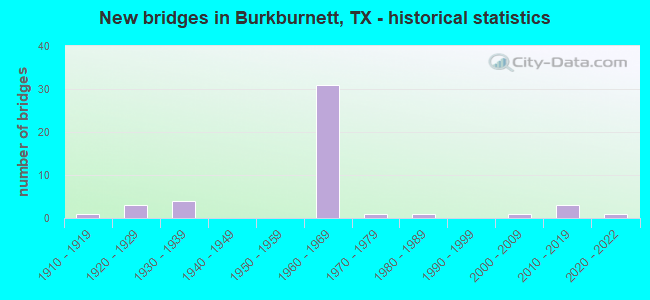
- New bridges - historical statistics
- 11910-1919
- 31920-1929
- 41930-1939
- 311960-1969
- 11970-1979
- 11980-1989
- 12000-2009
- 32010-2019
- 12020-2022

- Reconstructed bridges - Historical Statistics
- 31940-1949
- 01950-1959
- 11960-1969
- 21970-1979
- 01980-1989
- 11990-1999
- 12000-2009


- Bridge Condition - Deck
- 10.0%Very good
- 70.0%Good
- 20.0%Satisfactory

- Bridge Condition - Superstructure
- 20.0%Very good
- 55.0%Good
- 25.0%Satisfactory

- Bridge Condition - Substructure
- 5.0%Very good
- 30.0%Good
- 65.0%Satisfactory

- Bridge Condition - Channel
- 7.7%Very good
- 42.3%Good
- 34.6%Satisfactory
- 11.5%Fair
- 3.8%Poor

- Bridge Condition - Culverts
- 31.3%Good
- 50.0%Satisfactory
- 18.8%Fair
Find on map >> Show street view
Structure Number: 32430015602002, Location: 0.3 MI W OF IH 44 (Lat: 34.100550, Lng: -98.551647), Route carried "on" structure: State highway 267, Year Built: 1921, Year Reconstructed: 1949, Status: Open, Structure Length: 0.82m (2.69ft), Average Daily Traffic: 1,241 (year 2020), Truck Traffic: 16%, Average Future Daily Traffic: 1,600 (year 2033), Features Intersected: TRIB OF WILDHORSE CREEK
Minimum Vertical Clearance: 30+ m (98+ ft), Kilometerpoint: 2.198, Lanes on structure: 2, Owner: State Highway Agency, Approaching Roadway Width: 7.3m (24.0ft), Material/Design: Concrete, Design/Construction: Culvert, Number Of Spans In Main Unit: 4, Length of Maximum Span: 1.8m (5.9ft), Curb-To-Curb Width: 12.2m (40.0ft), Out-to-Out Width: 13.2m (43.3ft)
Condition: Channel: Good, Culverts: Satisfactory, Operating Rating: 39.9 metric tons, Method Used To Determine Operating Rating: Load Factor (LF), Inventory Rating: 23.6 metric tons, Method Used To Determine Inventory Rating: Load Factor (LF), Structural Evaluation: Equal to present minimum criteria, Deck Geometry: Better than present minimum criteria, Waterway Adequacy: Equal to present minimum criteria, Approach Roadway Alignment: Equal to present desirable criteria, Designated Inspection Frequency: Every 24 months, Inspection Date: May 2020, Deck Structure Type: Concrete Cast-file-Place, Wearing Surface/Protective System: Wearing Surface: Bituminous
Find on map >> Show street view
Structure Number: 32430015602003, Location: 1.20 MI SE OF IH 44 (Lat: 34.066919, Lng: -98.540542), Route carried "on" structure: State highway 240, Year Built: 1920, Year Reconstructed: 1949, Status: Open, Structure Length: 3.66m (12.01ft), Average Daily Traffic: 2,275 (year 2015), Truck Traffic: 24%, Average Future Daily Traffic: 6,150 (year 2033), Features Intersected: GILBERT CREEK
Minimum Vertical Clearance: 30+ m (98+ ft), Kilometerpoint: 7.406, Lanes on structure: 2, Owner: State Highway Agency, Approaching Roadway Width: 13.1m (43.0ft), Material/Design: Steel, Design/Construction: Stringer/Multi-beam, Number Of Spans In Main Unit: 1, Number Of Approach Spans: 4, Length of Maximum Span: 9.8m (32.2ft), Curb-To-Curb Width: 12.2m (40.0ft), Out-to-Out Width: 12.8m (42.0ft)
Condition: Deck: Satisfactory, Superstructure: Satisfactory, Substructure: Satisfactory, Channel: Good, Operating Rating: 42.6 metric tons, Method Used To Determine Operating Rating: Load Factor (LF), Inventory Rating: 25.4 metric tons, Method Used To Determine Inventory Rating: Load Factor (LF), Structural Evaluation: Equal to present minimum criteria, Deck Geometry: Equal to present minimum criteria, Waterway Adequacy: Equal to present minimum criteria, Approach Roadway Alignment: Equal to present desirable criteria, Designated Inspection Frequency: Every 24 months, Inspection Date: May 2020, Deck Structure Type: Concrete Cast-file-Place, Wearing Surface/Protective System: Wearing Surface: Bituminous
Find on map >> Show street view
Structure Number: 32430015602004, Location: 0.15 MI S OF FM 1177 (Lat: 34.047811, Lng: -98.525203), Route carried "on" structure: State highway 240, Year Built: 1918, Year Reconstructed: 1949, Status: Open, Structure Length: 1.07m (3.51ft), Average Daily Traffic: 1,987 (year 2015), Truck Traffic: 22%, Average Future Daily Traffic: 3,170 (year 2033), Features Intersected: TRIB OF GILBERT CREEK
Minimum Vertical Clearance: 30+ m (98+ ft), Kilometerpoint: 10.139, Lanes on structure: 2, Owner: State Highway Agency, Approaching Roadway Width: 11.6m (38.1ft), Material/Design: Concrete, Design/Construction: Culvert, Number Of Spans In Main Unit: 2, Length of Maximum Span: 4.9m (16.1ft), Curb-To-Curb Width: 13.4m (44.0ft), Out-to-Out Width: 14.2m (46.6ft)
Condition: Channel: Fair, Culverts: Fair, Operating Rating: 39.9 metric tons, Method Used To Determine Operating Rating: Load Factor (LF), Inventory Rating: 23.6 metric tons, Method Used To Determine Inventory Rating: Load Factor (LF), Structural Evaluation: Somewhat better than minimum adequacy, Deck Geometry: Equal to present desirable criteria, Waterway Adequacy: Equal to present minimum criteria, Approach Roadway Alignment: Equal to present desirable criteria, Designated Inspection Frequency: Every 24 months, Inspection Date: May 2020, Deck Structure Type: Concrete Cast-file-Place, Wearing Surface/Protective System: Wearing Surface: Bituminous
Find on map >> Show street view
Structure Number: 3243001560704, Location: 0.85 MI SW OF TX/OKLA SL (Lat: 34.100244, Lng: -98.546967), Route carried "on" structure: Interstate 44, Year Built: 1964, Status: Open, Structure Length: 4.39m (14.40ft), Average Daily Traffic: 6,929 (year 2019), Truck Traffic: 13%, Average Future Daily Traffic: 8,360 (year 2033), Design Load: HS 20, Features Intersected: LOOP 267/SH 240
Minimum Vertical Clearance: 30+ m (98+ ft), Kilometerpoint: 24.691, Lanes on structure: 2, Lanes under structure: 2, Owner: State Highway Agency, Approaching Roadway Width: 11.6m (38.1ft), Material/Design: Prestressed concrete, Design/Construction: Stringer/Multi-beam, Number Of Spans In Main Unit: 1, Number Of Approach Spans: 2, Length of Maximum Span: 18.9m (62.0ft), Curb-To-Curb Width: 11.7m (38.4ft), Out-to-Out Width: 12.6m (41.3ft)
Condition: Deck: Good, Superstructure: Good, Substructure: Satisfactory, Operating Rating: 68.0 metric tons, Method Used To Determine Operating Rating: Load Factor (LF), Inventory Rating: 40.8 metric tons, Method Used To Determine Inventory Rating: Load Factor (LF), Structural Evaluation: Equal to present minimum criteria, Deck Geometry: Equal to present minimum criteria, Underclear: Equal to present minimum criteria, Approach Roadway Alignment: Equal to present desirable criteria, Designated Inspection Frequency: Every 24 months, Inspection Date: June 2020, Deck Structure Type: Concrete Cast-file-Place
Find on map >> Show street view
Structure Number: 32430015607041, Location: 0.85 MI SW OF TX/OKLA SL (Lat: 34.100103, Lng: -98.546839), Route carried "on" structure: Interstate 44, Year Built: 1964, Status: Open, Structure Length: 4.39m (14.40ft), Average Daily Traffic: 6,964 (year 2019), Truck Traffic: 13%, Average Future Daily Traffic: 8,360 (year 2033), Design Load: HS 20, Features Intersected: LOOP 267/SH 240
Minimum Vertical Clearance: 30+ m (98+ ft), Kilometerpoint: 24.691, Lanes on structure: 2, Lanes under structure: 2, Owner: State Highway Agency, Approaching Roadway Width: 11.6m (38.1ft), Material/Design: Prestressed concrete, Design/Construction: Stringer/Multi-beam, Number Of Spans In Main Unit: 1, Number Of Approach Spans: 2, Length of Maximum Span: 18.9m (62.0ft), Curb-To-Curb Width: 11.7m (38.4ft), Out-to-Out Width: 12.6m (41.3ft)
Condition: Deck: Good, Superstructure: Good, Substructure: Satisfactory, Operating Rating: 68.0 metric tons, Method Used To Determine Operating Rating: Load Factor (LF), Inventory Rating: 40.8 metric tons, Method Used To Determine Inventory Rating: Load Factor (LF), Structural Evaluation: Equal to present minimum criteria, Deck Geometry: Equal to present minimum criteria, Underclear: Equal to present minimum criteria, Approach Roadway Alignment: Equal to present desirable criteria, Designated Inspection Frequency: Every 24 months, Inspection Date: June 2020, Deck Structure Type: Concrete Cast-file-Place
Find on map >> Show street view
Structure Number: 32430015607042, Location: 0.15 MI S OF LOOP 267 (Lat: 34.099022, Lng: -98.548683), Route carried "on" structure: Interstate 44, Year Built: 1964, Status: Open, Structure Length: 0.98m (3.22ft), Average Daily Traffic: 11,114 (year 2020), Truck Traffic: 13%, Average Future Daily Traffic: 16,720 (year 2033), Design Load: HS 20, Features Intersected: TRIB OF WILDHORSE CREEK
Minimum Vertical Clearance: 30+ m (98+ ft), Kilometerpoint: 24.465, Lanes on structure: 8, Owner: State Highway Agency, Approaching Roadway Width: 42.1m (138.1ft), Skew: 21 degrees, Material/Design: Concrete, Design/Construction: Culvert, Number Of Spans In Main Unit: 4, Length of Maximum Span: 2.1m (6.9ft)
Condition: Channel: Good, Culverts: Satisfactory, Operating Rating: 39.9 metric tons, Method Used To Determine Operating Rating: Load Factor (LF), Inventory Rating: 23.6 metric tons, Method Used To Determine Inventory Rating: Load Factor (LF), Structural Evaluation: Somewhat better than minimum adequacy, Waterway Adequacy: Superior to present desirable criteria, Approach Roadway Alignment: Equal to present desirable criteria, Designated Inspection Frequency: Every 24 months, Inspection Date: May 2020
Find on map >> Show street view
Structure Number: 32430015607043, Location: 0.9 MI SW OF LOOP 267 (Lat: 34.091375, Lng: -98.557458), Route carried "on" structure: Interstate 44, Year Built: 1964, Status: Open, Structure Length: 4.69m (15.39ft), Average Daily Traffic: 6,929 (year 2019), Truck Traffic: 13%, Average Future Daily Traffic: 8,360 (year 2033), Design Load: HS 20, Features Intersected: SPUR 383/GLENDALE ST
Minimum Vertical Clearance: 30+ m (98+ ft), Kilometerpoint: 23.278, Lanes on structure: 2, Lanes under structure: 3, Owner: State Highway Agency, Approaching Roadway Width: 11.6m (38.1ft), Material/Design: Prestressed concrete, Design/Construction: Stringer/Multi-beam, Number Of Spans In Main Unit: 1, Number Of Approach Spans: 2, Length of Maximum Span: 21.9m (71.9ft), Curb-To-Curb Width: 11.7m (38.4ft), Out-to-Out Width: 12.6m (41.3ft)
Condition: Deck: Satisfactory, Superstructure: Satisfactory, Substructure: Good, Operating Rating: 68.0 metric tons, Method Used To Determine Operating Rating: Load Factor (LF), Inventory Rating: 34.5 metric tons, Method Used To Determine Inventory Rating: Load Factor (LF), Structural Evaluation: Equal to present minimum criteria, Deck Geometry: Equal to present minimum criteria, Underclear: Equal to present minimum criteria, Approach Roadway Alignment: Equal to present desirable criteria, Designated Inspection Frequency: Every 24 months, Inspection Date: June 2020, Deck Structure Type: Concrete Cast-file-Place
Find on map >> Show street view
Structure Number: 32430015607044, Location: 0.9 MI SW OF LOOP 267 (Lat: 34.091353, Lng: -98.557247), Route carried "on" structure: Interstate 44, Year Built: 1964, Status: Open, Structure Length: 4.69m (15.39ft), Average Daily Traffic: 6,964 (year 2019), Truck Traffic: 13%, Average Future Daily Traffic: 8,360 (year 2033), Design Load: HS 20, Features Intersected: SPUR 383/GLENDALE ST
Minimum Vertical Clearance: 30+ m (98+ ft), Kilometerpoint: 23.278, Lanes on structure: 2, Lanes under structure: 3, Owner: State Highway Agency, Approaching Roadway Width: 11.6m (38.1ft), Material/Design: Prestressed concrete, Design/Construction: Stringer/Multi-beam, Number Of Spans In Main Unit: 1, Number Of Approach Spans: 2, Length of Maximum Span: 21.9m (71.9ft), Curb-To-Curb Width: 11.7m (38.4ft), Out-to-Out Width: 12.6m (41.3ft)
Condition: Deck: Satisfactory, Superstructure: Good, Substructure: Satisfactory, Operating Rating: 68.0 metric tons, Method Used To Determine Operating Rating: Load Factor (LF), Inventory Rating: 34.5 metric tons, Method Used To Determine Inventory Rating: Load Factor (LF), Structural Evaluation: Equal to present minimum criteria, Deck Geometry: Equal to present minimum criteria, Underclear: Somewhat better than minimum adequacy, Approach Roadway Alignment: Equal to present desirable criteria, Designated Inspection Frequency: Every 24 months, Inspection Date: June 2020, Deck Structure Type: Concrete Cast-file-Place
Find on map >> Show street view
Structure Number: 32430015607045, Location: 0.14 MI S OF SPUR 383 (Lat: 34.089303, Lng: -98.557000), Route carried "on" structure: ServiceInterstate 44, Year Built: 1964, Status: Open, Structure Length: 0.70m (2.30ft), Average Daily Traffic: 1,100 (year 2010), Truck Traffic: 15%, Average Future Daily Traffic: 1,620 (year 2030), Design Load: HS 20, Features Intersected: DRAW
Minimum Vertical Clearance: 30+ m (98+ ft), Kilometerpoint: 23.025, Lanes on structure: 2, Owner: State Highway Agency, Approaching Roadway Width: 9.8m (32.2ft), Material/Design: Concrete, Design/Construction: Culvert, Number Of Spans In Main Unit: 4, Length of Maximum Span: 1.5m (4.9ft)
Condition: Channel: Satisfactory, Culverts: Good, Operating Rating: 39.9 metric tons, Method Used To Determine Operating Rating: Load Factor (LF), Inventory Rating: 23.6 metric tons, Method Used To Determine Inventory Rating: Load Factor (LF), Structural Evaluation: Somewhat better than minimum adequacy, Waterway Adequacy: Superior to present desirable criteria, Approach Roadway Alignment: Equal to present desirable criteria, Designated Inspection Frequency: Every 24 months, Inspection Date: May 2020
Find on map >> Show street view
Structure Number: 32430015607046, Location: 1.65 MI N OF FM 3429 (Lat: 34.079925, Lng: -98.557692), Route carried "on" structure: Interstate 44, Year Built: 1964, Status: Open, Structure Length: 3.84m (12.60ft), Average Daily Traffic: 6,929 (year 2019), Truck Traffic: 13%, Average Future Daily Traffic: 8,360 (year 2033), Design Load: HS 20, Features Intersected: SH 240/LOOP 267 WB
Minimum Vertical Clearance: 30+ m (98+ ft), Kilometerpoint: 21.984, Lanes on structure: 2, Lanes under structure: 2, Owner: State Highway Agency, Approaching Roadway Width: 11.6m (38.1ft), Material/Design: Prestressed concrete, Design/Construction: Stringer/Multi-beam, Number Of Spans In Main Unit: 3, Length of Maximum Span: 13.7m (44.9ft), Curb-To-Curb Width: 11.7m (38.4ft), Out-to-Out Width: 12.6m (41.3ft)
Condition: Deck: Good, Superstructure: Good, Substructure: Good, Operating Rating: 68.0 metric tons, Method Used To Determine Operating Rating: Load Factor (LF), Inventory Rating: 40.8 metric tons, Method Used To Determine Inventory Rating: Load Factor (LF), Structural Evaluation: Better than present minimum criteria, Deck Geometry: Equal to present minimum criteria, Underclear: Somewhat better than minimum adequacy, Approach Roadway Alignment: Equal to present desirable criteria, Designated Inspection Frequency: Every 24 months, Inspection Date: June 2020, Deck Structure Type: Concrete Cast-file-Place, Wearing Surface/Protective System: Wearing Surface: Bituminous
Find on map >> Show street view
Structure Number: 32430015607047, Location: 1.65 MI NORTH OF FM 3429 (Lat: 34.079633, Lng: -98.557381), Route carried "on" structure: Interstate 44, Year Built: 1964, Status: Open, Structure Length: 3.84m (12.60ft), Average Daily Traffic: 6,964 (year 2019), Truck Traffic: 13%, Average Future Daily Traffic: 8,360 (year 2033), Design Load: HS 20, Features Intersected: SH 240/LOOP 267 WB
Minimum Vertical Clearance: 30+ m (98+ ft), Kilometerpoint: 21.984, Lanes on structure: 2, Lanes under structure: 2, Owner: State Highway Agency, Approaching Roadway Width: 11.6m (38.1ft), Material/Design: Prestressed concrete, Design/Construction: Stringer/Multi-beam, Number Of Spans In Main Unit: 3, Length of Maximum Span: 13.7m (44.9ft), Curb-To-Curb Width: 11.7m (38.4ft), Out-to-Out Width: 12.6m (41.3ft)
Condition: Deck: Good, Superstructure: Good, Substructure: Satisfactory, Operating Rating: 68.0 metric tons, Method Used To Determine Operating Rating: Load Factor (LF), Inventory Rating: 40.8 metric tons, Method Used To Determine Inventory Rating: Load Factor (LF), Structural Evaluation: Equal to present minimum criteria, Deck Geometry: Equal to present minimum criteria, Underclear: Somewhat better than minimum adequacy, Approach Roadway Alignment: Equal to present desirable criteria, Designated Inspection Frequency: Every 24 months, Inspection Date: June 2020, Deck Structure Type: Concrete Cast-file-Place, Wearing Surface/Protective System: Wearing Surface: Bituminous
Find on map >> Show street view
Structure Number: 32430015607048, Location: 1.55 MI NORTH OF FM 3429 (Lat: 34.078514, Lng: -98.557722), Route carried "on" structure: Interstate 44, Year Built: 1964, Status: Open, Structure Length: 3.84m (12.60ft), Average Daily Traffic: 6,929 (year 2019), Truck Traffic: 13%, Average Future Daily Traffic: 8,360 (year 2033), Design Load: HS 20, Features Intersected: SH 240/LOOP 267 EB
Minimum Vertical Clearance: 30+ m (98+ ft), Kilometerpoint: 21.824, Lanes on structure: 2, Lanes under structure: 2, Owner: State Highway Agency, Approaching Roadway Width: 11.6m (38.1ft), Material/Design: Prestressed concrete, Design/Construction: Stringer/Multi-beam, Number Of Spans In Main Unit: 3, Length of Maximum Span: 13.7m (44.9ft), Curb-To-Curb Width: 11.7m (38.4ft), Out-to-Out Width: 12.6m (41.3ft)
Condition: Deck: Good, Superstructure: Good, Substructure: Satisfactory, Operating Rating: 68.0 metric tons, Method Used To Determine Operating Rating: Load Factor (LF), Inventory Rating: 40.8 metric tons, Method Used To Determine Inventory Rating: Load Factor (LF), Structural Evaluation: Equal to present minimum criteria, Deck Geometry: Equal to present minimum criteria, Underclear: Meets minimum limits, Approach Roadway Alignment: Equal to present desirable criteria, Designated Inspection Frequency: Every 24 months, Inspection Date: June 2020, Deck Structure Type: Concrete Cast-file-Place, Wearing Surface/Protective System: Wearing Surface: Bituminous
Find on map >> Show street view
Structure Number: 32430015607049, Location: 1.55 MI NORTH OF FM 3429 (Lat: 34.078186, Lng: -98.557403), Route carried "on" structure: Interstate 44, Year Built: 1964, Status: Open, Structure Length: 3.84m (12.60ft), Average Daily Traffic: 9,277 (year 2019), Truck Traffic: 13%, Average Future Daily Traffic: 8,360 (year 2033), Design Load: HS 20, Features Intersected: SH 240/LOOP 267 EB
Minimum Vertical Clearance: 30+ m (98+ ft), Kilometerpoint: 21.824, Lanes on structure: 2, Lanes under structure: 2, Owner: State Highway Agency, Approaching Roadway Width: 11.6m (38.1ft), Material/Design: Prestressed concrete, Design/Construction: Stringer/Multi-beam, Number Of Spans In Main Unit: 3, Length of Maximum Span: 13.7m (44.9ft), Curb-To-Curb Width: 11.7m (38.4ft), Out-to-Out Width: 12.6m (41.3ft)
Condition: Deck: Good, Superstructure: Good, Substructure: Satisfactory, Operating Rating: 68.0 metric tons, Method Used To Determine Operating Rating: Load Factor (LF), Inventory Rating: 40.8 metric tons, Method Used To Determine Inventory Rating: Load Factor (LF), Structural Evaluation: Equal to present minimum criteria, Deck Geometry: Equal to present minimum criteria, Underclear: Meets minimum limits, Approach Roadway Alignment: Equal to present desirable criteria, Designated Inspection Frequency: Every 24 months, Inspection Date: June 2020, Deck Structure Type: Concrete Cast-file-Place, Wearing Surface/Protective System: Wearing Surface: Bituminous
Find on map >> Show street view
Structure Number: 3243001560705, Location: 1.0 MI S OF SH 240 (Lat: 34.064664, Lng: -98.557731), Route carried "on" structure: ServiceInterstate 44, Year Built: 1964, Status: Open, Structure Length: 4.15m (13.62ft), Average Daily Traffic: 110 (year 2013), Truck Traffic: 11%, Average Future Daily Traffic: 160 (year 2033), Design Load: H 20, Features Intersected: GILBERT CREEK
Minimum Vertical Clearance: 30+ m (98+ ft), Kilometerpoint: 20.281, Lanes on structure: 2, Owner: State Highway Agency, Approaching Roadway Width: 9.1m (29.9ft), Skew: 1 degrees, Material/Design: Prestressed concrete, Design/Construction: Stringer/Multi-beam, Number Of Spans In Main Unit: 3, Length of Maximum Span: 13.7m (44.9ft), Curb or Sidewalk Widths: Left: 1.0m (3.3ft), Right: 0.0m, Curb-To-Curb Width: 8.5m (27.9ft), Out-to-Out Width: 10.5m (34.4ft)
Condition: Deck: Good, Superstructure: Satisfactory, Substructure: Satisfactory, Channel: Satisfactory, Operating Rating: 58.0 metric tons, Method Used To Determine Operating Rating: Load Factor (LF), Inventory Rating: 25.4 metric tons, Method Used To Determine Inventory Rating: Load Factor (LF), Structural Evaluation: Equal to present minimum criteria, Deck Geometry: High priority of corrective action, Waterway Adequacy: Superior to present desirable criteria, Approach Roadway Alignment: Equal to present desirable criteria, Length Of Structure Improvement: 4.15m (13.62ft), Designated Inspection Frequency: Every 24 months, Inspection Date: June 2020, Deck Structure Type: Concrete Cast-file-Place, Wearing Surface/Protective System: Wearing Surface: Bituminous
Find on map >> Show street view
Structure Number: 32430015607051, Location: 1.00 MI S OF SH 240 (Lat: 34.064631, Lng: -98.557506), Route carried "on" structure: Interstate 44, Year Built: 1964, Status: Open, Structure Length: 4.15m (13.62ft), Average Daily Traffic: 9,318 (year 2019), Truck Traffic: 13%, Average Future Daily Traffic: 10,480 (year 2033), Design Load: HS 20, Features Intersected: GILBERT CREEK
Minimum Vertical Clearance: 30+ m (98+ ft), Kilometerpoint: 20.281, Lanes on structure: 2, Owner: State Highway Agency, Approaching Roadway Width: 11.6m (38.1ft), Skew: 1 degrees, Material/Design: Prestressed concrete, Design/Construction: Stringer/Multi-beam, Number Of Spans In Main Unit: 3, Length of Maximum Span: 13.7m (44.9ft), Curb-To-Curb Width: 11.8m (38.7ft), Out-to-Out Width: 12.6m (41.3ft)
Condition: Deck: Satisfactory, Superstructure: Good, Substructure: Satisfactory, Channel: Satisfactory, Operating Rating: 68.0 metric tons, Method Used To Determine Operating Rating: Load Factor (LF), Inventory Rating: 40.8 metric tons, Method Used To Determine Inventory Rating: Load Factor (LF), Structural Evaluation: Equal to present minimum criteria, Deck Geometry: Equal to present minimum criteria, Waterway Adequacy: Superior to present desirable criteria, Approach Roadway Alignment: Equal to present desirable criteria, Designated Inspection Frequency: Every 24 months, Inspection Date: June 2020, Deck Structure Type: Concrete Cast-file-Place, Wearing Surface/Protective System: Wearing Surface: Bituminous
Find on map >> Show street view
Structure Number: 32430015607052, Location: 1.0 MI S OF SH 240 (Lat: 34.064214, Lng: -98.557167), Route carried "on" structure: Interstate 44, Year Built: 1964, Status: Open, Structure Length: 4.15m (13.62ft), Average Daily Traffic: 9,277 (year 2019), Truck Traffic: 13%, Average Future Daily Traffic: 10,480 (year 2033), Design Load: HS 20, Features Intersected: GILBERT CREEK
Minimum Vertical Clearance: 30+ m (98+ ft), Kilometerpoint: 20.281, Lanes on structure: 2, Owner: State Highway Agency, Approaching Roadway Width: 11.6m (38.1ft), Skew: 1 degrees, Material/Design: Prestressed concrete, Design/Construction: Stringer/Multi-beam, Number Of Spans In Main Unit: 3, Length of Maximum Span: 13.7m (44.9ft), Curb-To-Curb Width: 11.8m (38.7ft), Out-to-Out Width: 12.6m (41.3ft)
Condition: Deck: Good, Superstructure: Good, Substructure: Good, Channel: Good, Operating Rating: 68.0 metric tons, Method Used To Determine Operating Rating: Load Factor (LF), Inventory Rating: 40.8 metric tons, Method Used To Determine Inventory Rating: Load Factor (LF), Structural Evaluation: Better than present minimum criteria, Deck Geometry: Equal to present minimum criteria, Waterway Adequacy: Superior to present desirable criteria, Approach Roadway Alignment: Equal to present desirable criteria, Designated Inspection Frequency: Every 24 months, Inspection Date: June 2020, Deck Structure Type: Concrete Cast-file-Place, Wearing Surface/Protective System: Wearing Surface: Bituminous
Find on map >> Show street view
Structure Number: 32430015607053, Location: 1.0 MI S OF SH 240 (Lat: 34.064161, Lng: -98.556922), Route carried "on" structure: ServiceInterstate 44, Year Built: 1964, Status: Open, Structure Length: 4.15m (13.62ft), Average Daily Traffic: 830 (year 2013), Truck Traffic: 12%, Average Future Daily Traffic: 1,170 (year 2033), Design Load: H 20, Features Intersected: GILBERT CREEK
Minimum Vertical Clearance: 30+ m (98+ ft), Kilometerpoint: 20.281, Lanes on structure: 2, Owner: State Highway Agency, Approaching Roadway Width: 9.1m (29.9ft), Skew: 1 degrees, Material/Design: Prestressed concrete, Design/Construction: Stringer/Multi-beam, Number Of Spans In Main Unit: 3, Length of Maximum Span: 13.7m (44.9ft), Curb or Sidewalk Widths: Left: 0.0m, Right: 1.0m (3.3ft), Curb-To-Curb Width: 8.5m (27.9ft), Out-to-Out Width: 10.5m (34.4ft)
Condition: Deck: Good, Superstructure: Very good, Substructure: Satisfactory, Channel: Good, Operating Rating: 59.0 metric tons, Method Used To Determine Operating Rating: Load Factor (LF), Inventory Rating: 26.3 metric tons, Method Used To Determine Inventory Rating: Load Factor (LF), Structural Evaluation: Equal to present minimum criteria, Deck Geometry: High priority of corrective action, Waterway Adequacy: Superior to present desirable criteria, Approach Roadway Alignment: Equal to present desirable criteria, Length Of Structure Improvement: 4.15m (13.62ft), Designated Inspection Frequency: Every 24 months, Inspection Date: June 2020, Deck Structure Type: Concrete Cast-file-Place, Wearing Surface/Protective System: Wearing Surface: Bituminous
Find on map >> Show street view
Structure Number: 32430015607054, Location: 1.55 MI S OF SH 240 (Lat: 34.055731, Lng: -98.557167), Route carried "on" structure: Interstate 44, Year Built: 1964, Status: Open, Structure Length: 4.15m (13.62ft), Average Daily Traffic: 11,317 (year 2019), Truck Traffic: 13%, Average Future Daily Traffic: 10,480 (year 2033), Design Load: HS 20, Features Intersected: DANIELS RD
Minimum Vertical Clearance: 30+ m (98+ ft), Kilometerpoint: 19.322, Lanes on structure: 2, Lanes under structure: 2, Owner: State Highway Agency, Approaching Roadway Width: 11.6m (38.1ft), Material/Design: Prestressed concrete, Design/Construction: Stringer/Multi-beam, Number Of Spans In Main Unit: 3, Length of Maximum Span: 13.7m (44.9ft), Curb-To-Curb Width: 11.7m (38.4ft), Out-to-Out Width: 12.6m (41.3ft)
Condition: Deck: Good, Superstructure: Satisfactory, Substructure: Satisfactory, Operating Rating: 68.0 metric tons, Method Used To Determine Operating Rating: Load Factor (LF), Inventory Rating: 40.8 metric tons, Method Used To Determine Inventory Rating: Load Factor (LF), Structural Evaluation: Equal to present minimum criteria, Deck Geometry: Equal to present minimum criteria, Underclear: Somewhat better than minimum adequacy, Approach Roadway Alignment: Equal to present desirable criteria, Designated Inspection Frequency: Every 24 months, Inspection Date: June 2020, Deck Structure Type: Concrete Cast-file-Place, Wearing Surface/Protective System: Wearing Surface: Bituminous
Find on map >> Show street view
Structure Number: 32430015607055, Location: 1.55 MI S OF SH 240 (Lat: 34.055731, Lng: -98.556953), Route carried "on" structure: Interstate 44, Year Built: 1964, Status: Open, Structure Length: 4.15m (13.62ft), Average Daily Traffic: 11,556 (year 2019), Truck Traffic: 13%, Average Future Daily Traffic: 10,480 (year 2033), Design Load: HS 20, Features Intersected: DANIELS RD
Minimum Vertical Clearance: 30+ m (98+ ft), Kilometerpoint: 19.322, Lanes on structure: 2, Lanes under structure: 2, Owner: State Highway Agency, Approaching Roadway Width: 11.6m (38.1ft), Material/Design: Prestressed concrete, Design/Construction: Stringer/Multi-beam, Number Of Spans In Main Unit: 3, Length of Maximum Span: 13.7m (44.9ft), Curb-To-Curb Width: 11.7m (38.4ft), Out-to-Out Width: 12.6m (41.3ft)
Condition: Deck: Good, Superstructure: Satisfactory, Substructure: Satisfactory, Operating Rating: 68.0 metric tons, Method Used To Determine Operating Rating: Load Factor (LF), Inventory Rating: 40.8 metric tons, Method Used To Determine Inventory Rating: Load Factor (LF), Structural Evaluation: Equal to present minimum criteria, Deck Geometry: Equal to present minimum criteria, Underclear: Somewhat better than minimum adequacy, Approach Roadway Alignment: Equal to present desirable criteria, Designated Inspection Frequency: Every 24 months, Inspection Date: June 2020, Deck Structure Type: Concrete Cast-file-Place, Wearing Surface/Protective System: Wearing Surface: Bituminous
Find on map >> Show street view
Structure Number: 32430015607056, Location: 0.7 MI S OF FM 3429 (Lat: 34.045564, Lng: -98.557933), Route carried "on" structure: Interstate 44, Year Built: 1964, Year Reconstructed: 1984, Status: Open, Structure Length: 0.82m (2.69ft), Average Daily Traffic: 22,291 (year 2018), Truck Traffic: 11%, Average Future Daily Traffic: 26,590 (year 2033), Design Load: HS 20, Features Intersected: TRIB OF GILBERT CREEK
Minimum Vertical Clearance: 30+ m (98+ ft), Kilometerpoint: 18.158, Lanes on structure: 8, Owner: State Highway Agency, Approaching Roadway Width: 41.5m (136.2ft), Skew: 9 degrees, Material/Design: Concrete, Design/Construction: Culvert, Number Of Spans In Main Unit: 4, Length of Maximum Span: 1.8m (5.9ft)
Condition: Channel: Good, Culverts: Good, Operating Rating: 39.9 metric tons, Method Used To Determine Operating Rating: Load Factor (LF), Inventory Rating: 23.6 metric tons, Method Used To Determine Inventory Rating: Load Factor (LF), Structural Evaluation: Somewhat better than minimum adequacy, Waterway Adequacy: Equal to present minimum criteria, Approach Roadway Alignment: Equal to present desirable criteria, Designated Inspection Frequency: Every 24 months, Inspection Date: June 2020
Find on map >> Show street view
Structure Number: 32430015607066, Location: TEXAS & OKLA STATE LINE (Lat: 34.107067, Lng: -98.536078), Route carried "on" structure: Interstate 44, Year Built: 1978, Status: Open, Structure Length: 116.10m (380.91ft), Average Daily Traffic: 5,630 (year 2013), Truck Traffic: 13%, Average Future Daily Traffic: 7,880 (year 2033), Design Load: HS 20, Features Intersected: RED RIVER
Minimum Vertical Clearance: 30+ m (98+ ft), Kilometerpoint: 25.268, Lanes on structure: 2, Owner: State Agenciy, Approaching Roadway Width: 11.6m (38.1ft), Material/Design: Prestressed concrete, Design/Construction: Stringer/Multi-beam, Number Of Spans In Main Unit: 47, Length of Maximum Span: 25.0m (82.0ft), Curb-To-Curb Width: 11.6m (38.1ft), Out-to-Out Width: 12.3m (40.4ft)
Condition: Deck: Good, Superstructure: Good, Substructure: Satisfactory, Channel: Fair, Operating Rating: 54.4 metric tons, Method Used To Determine Operating Rating: Assigned ratings based on Allowable Stress Design (ASD) reported in metric tons, Inventory Rating: 32.7 metric tons, Method Used To Determine Inventory Rating: Assigned ratings based on Allowable Stress Design (ASD) reported in metric tons, Structural Evaluation: Equal to present minimum criteria, Deck Geometry: Equal to present minimum criteria, Waterway Adequacy: Superior to present desirable criteria, Approach Roadway Alignment: Equal to present desirable criteria, Designated Inspection Frequency: Every 24 months, Inspection Date: June 2020, Deck Structure Type: Concrete Cast-file-Place
Find on map >> Show street view
Structure Number: 3243001560709, Location: AT OKLAHOMA STATE LINE (Lat: 34.107222, Lng: -98.536181), Route carried "on" structure: Interstate 44, Year Built: 2003, Status: Open, Structure Length: 119.42m (391.80ft), Average Daily Traffic: 5,000 (year 2010), Truck Traffic: 17%, Average Future Daily Traffic: 10,000 (year 2030), Design Load: HL 93, Features Intersected: RED RIVER
Minimum Vertical Clearance: 30+ m (98+ ft), Kilometerpoint: 25.371, Lanes on structure: 2, Owner: State Highway Agency, Approaching Roadway Width: 11.6m (38.1ft), Material/Design: Prestressed concrete, Design/Construction: Stringer/Multi-beam, Number Of Spans In Main Unit: 48, Length of Maximum Span: 29.3m (96.1ft), Curb-To-Curb Width: 11.4m (37.4ft), Out-to-Out Width: 12.3m (40.4ft)
Condition: Deck: Good, Superstructure: Good, Substructure: Good, Channel: Satisfactory, Operating Rating: 54.4 metric tons, Method Used To Determine Operating Rating: Assigned ratings based on Load and Resistance Factor Design (LRFD) reported in metric tons, Inventory Rating: 32.7 metric tons, Method Used To Determine Inventory Rating: Assigned ratings based on Load and Resistance Factor Design (LRFD) reported in metric tons, Structural Evaluation: Better than present minimum criteria, Deck Geometry: Somewhat better than minimum adequacy, Waterway Adequacy: Superior to present desirable criteria, Approach Roadway Alignment: Equal to present desirable criteria, Designated Inspection Frequency: Every 24 months, Inspection Date: June 2020, Deck Structure Type: Concrete Cast-file-Place
Find on map >> Show street view
Structure Number: 32430015607207, Location: 0.95 MI S OF FM 3429 (Lat: 34.042131, Lng: -98.559208), Route carried "on" structure: ServiceInterstate 44, Year Built: 2015, Status: Open, Structure Length: 1.22m (4.00ft), Average Daily Traffic: 1,900 (year 2010), Truck Traffic: 12%, Average Future Daily Traffic: 2,660 (year 2030), Design Load: HL 93, Features Intersected: TRIB OF GILBERT CREEK
Minimum Vertical Clearance: 30+ m (98+ ft), Kilometerpoint: 17.778, Lanes on structure: 2, Owner: State Highway Agency, Approaching Roadway Width: 4.0m (13.1ft), Material/Design: Prestressed concrete, Design/Construction: Slab, Number Of Spans In Main Unit: 1, Length of Maximum Span: 12.2m (40.0ft), Curb-To-Curb Width: 7.1m (23.3ft), Out-to-Out Width: 7.9m (25.9ft)
Condition: Deck: Very good, Superstructure: Very good, Substructure: Very good, Channel: Very good, Operating Rating: 54.4 metric tons, Method Used To Determine Operating Rating: Assigned ratings based on Load and Resistance Factor Design (LRFD) reported in metric tons, Inventory Rating: 32.7 metric tons, Method Used To Determine Inventory Rating: Assigned ratings based on Load and Resistance Factor Design (LRFD) reported in metric tons, Structural Evaluation: Equal to present desirable criteria, Deck Geometry: High priority of corrective action, Waterway Adequacy: Better than present minimum criteria, Approach Roadway Alignment: Equal to present desirable criteria, Designated Inspection Frequency: Every 24 months, Inspection Date: July 2020, Deck Structure Type: Concrete Cast-file-Place, Wearing Surface/Protective System: Deck Protection: Epoxy Coated Reinforcing
Find on map >> Show street view
Structure Number: 3243005140401, Location: 0.15 MI E OF SH 240 (Lat: 34.049653, Lng: -98.522553), Route carried "on" structure: State highway 1177, Year Built: 1930, Year Reconstructed: 1960, Status: Open, Structure Length: 0.94m (3.08ft), Average Daily Traffic: 1,109 (year 2020), Truck Traffic: 13%, Average Future Daily Traffic: 1,620 (year 2033), Features Intersected: TRIB OF GILBERT CREEK
Minimum Vertical Clearance: 30+ m (98+ ft), Kilometerpoint: 8.291, Lanes on structure: 2, Owner: State Highway Agency, Approaching Roadway Width: 6.7m (22.0ft), Material/Design: Concrete, Design/Construction: Culvert, Number Of Spans In Main Unit: 2, Length of Maximum Span: 4.3m (14.1ft), Curb-To-Curb Width: 9.0m (29.5ft), Out-to-Out Width: 9.6m (31.5ft)
Condition: Channel: Good, Culverts: Fair, Operating Rating: 32.7 metric tons, Method Used To Determine Operating Rating: Field evaluation and documented engineering judgment, Inventory Rating: 24.5 metric tons, Method Used To Determine Inventory Rating: Field evaluation and documented engineering judgment, Structural Evaluation: Somewhat better than minimum adequacy, Deck Geometry: Somewhat better than minimum adequacy, Waterway Adequacy: Equal to present minimum criteria, Approach Roadway Alignment: Equal to present desirable criteria, Designated Inspection Frequency: Every 24 months, Inspection Date: June 2020, Deck Structure Type: Concrete Cast-file-Place, Wearing Surface/Protective System: Wearing Surface: Bituminous
Find on map >> Show street view
Structure Number: 32430080201007, Location: 4.15 MI S OF SH 240 (Lat: 34.037331, Lng: -98.601978), Route carried "on" structure: State highway 369, Year Built: 1960, Year Reconstructed: 2004, Status: Open, Structure Length: 1.31m (4.30ft), Average Daily Traffic: 1,346 (year 2020), Truck Traffic: 6%, Average Future Daily Traffic: 1,420 (year 2033), Features Intersected: GILBERT CREEK
Minimum Vertical Clearance: 30+ m (98+ ft), Kilometerpoint: 6.690, Lanes on structure: 2, Owner: State Highway Agency, Approaching Roadway Width: 13.7m (44.9ft), Material/Design: Concrete, Design/Construction: Culvert, Number Of Spans In Main Unit: 4, Length of Maximum Span: 3.0m (9.8ft)
Condition: Channel: Satisfactory, Culverts: Satisfactory, Operating Rating: 39.9 metric tons, Method Used To Determine Operating Rating: Load Factor (LF), Inventory Rating: 23.6 metric tons, Method Used To Determine Inventory Rating: Load Factor (LF), Structural Evaluation: Equal to present minimum criteria, Waterway Adequacy: Equal to present minimum criteria, Approach Roadway Alignment: Equal to present desirable criteria, Designated Inspection Frequency: Every 24 months, Inspection Date: May 2020
Find on map >> Show street view
Structure Number: 32430080201008, Location: 1.8 MI S OF SH 240 (Lat: 34.070342, Lng: -98.596725), Route carried "on" structure: State highway 369, Year Built: 1960, Year Reconstructed: 2005, Status: Open, Structure Length: 0.67m (2.20ft), Average Daily Traffic: 1,317 (year 2020), Truck Traffic: 5%, Average Future Daily Traffic: 1,860 (year 2033), Features Intersected: TRIB OF GILBERT CREEK
Minimum Vertical Clearance: 30+ m (98+ ft), Kilometerpoint: 2.881, Lanes on structure: 2, Owner: State Highway Agency, Approaching Roadway Width: 13.7m (44.9ft), Material/Design: Concrete, Design/Construction: Culvert, Number Of Spans In Main Unit: 2, Length of Maximum Span: 3.0m (9.8ft), Curb-To-Curb Width: 17.1m (56.1ft), Out-to-Out Width: 17.9m (58.7ft)
Condition: Channel: Good, Culverts: Good, Operating Rating: 39.9 metric tons, Method Used To Determine Operating Rating: Load Factor (LF), Inventory Rating: 23.6 metric tons, Method Used To Determine Inventory Rating: Load Factor (LF), Structural Evaluation: Equal to present minimum criteria, Deck Geometry: Superior to present desirable criteria, Waterway Adequacy: Equal to present minimum criteria, Approach Roadway Alignment: Equal to present desirable criteria, Designated Inspection Frequency: Every 24 months, Inspection Date: May 2020, Deck Structure Type: Concrete Cast-file-Place, Wearing Surface/Protective System: Wearing Surface: Bituminous
Find on map >> Show street view
Structure Number: 32430320301001, Location: 0.50 MI W OF IH 44 (Lat: 34.056411, Lng: -98.565050), Route carried "on" structure: State highway 3429, Year Built: 1984, Status: Open, Structure Length: 2.23m (7.32ft), Average Daily Traffic: 5,150 (year 2020), Truck Traffic: 19%, Average Future Daily Traffic: 6,210 (year 2033), Design Load: HS 20, Features Intersected: GILBERT CREEK
Minimum Vertical Clearance: 30+ m (98+ ft), Kilometerpoint: 2.892, Lanes on structure: 2, Owner: State Highway Agency, Approaching Roadway Width: 12.2m (40.0ft), Material/Design: Concrete, Design/Construction: Culvert, Number Of Spans In Main Unit: 6, Length of Maximum Span: 3.0m (9.8ft), Curb-To-Curb Width: 16.5m (54.1ft), Out-to-Out Width: 21.0m (68.9ft)
Condition: Channel: Satisfactory, Culverts: Good, Operating Rating: 39.9 metric tons, Method Used To Determine Operating Rating: Load Factor (LF), Inventory Rating: 23.6 metric tons, Method Used To Determine Inventory Rating: Load Factor (LF), Structural Evaluation: Somewhat better than minimum adequacy, Deck Geometry: Superior to present desirable criteria, Waterway Adequacy: Equal to present minimum criteria, Approach Roadway Alignment: Equal to present minimum criteria, Designated Inspection Frequency: Every 24 months, Inspection Date: June 2020, Deck Structure Type: Concrete Cast-file-Place, Wearing Surface/Protective System: Wearing Surface: Bituminous
Find on map >> Show street view
Structure Number: 32430320301002, Location: 0.65 MI NW OF IH 44 (Lat: 34.059131, Lng: -98.565814), Route carried "on" structure: State highway 3429, Year Built: 1931, Year Reconstructed: 1984, Status: Open, Structure Length: 0.76m (2.49ft), Average Daily Traffic: 5,150 (year 2020), Truck Traffic: 19%, Average Future Daily Traffic: 6,210 (year 2033), Features Intersected: TRIB OF GILBERT CREEK
Minimum Vertical Clearance: 30+ m (98+ ft), Kilometerpoint: 2.594, Lanes on structure: 2, Owner: State Highway Agency, Approaching Roadway Width: 12.2m (40.0ft), Material/Design: Concrete, Design/Construction: Culvert, Number Of Spans In Main Unit: 2, Length of Maximum Span: 3.4m (11.2ft)
Condition: Channel: Good, Culverts: Satisfactory, Operating Rating: 32.7 metric tons, Method Used To Determine Operating Rating: Field evaluation and documented engineering judgment, Inventory Rating: 24.5 metric tons, Method Used To Determine Inventory Rating: Field evaluation and documented engineering judgment, Structural Evaluation: Equal to present minimum criteria, Waterway Adequacy: Equal to present minimum criteria, Approach Roadway Alignment: Equal to present desirable criteria, Designated Inspection Frequency: Every 24 months, Inspection Date: May 2020
Find on map >> Show street view
Structure Number: 32430AA0109002, Location: 0.75 MI E OF FM 369 (Lat: 34.052025, Lng: -98.588514), Route carried "on" structure: County highway 109, Year Built: 2020, Status: Open, Structure Length: 0.76m (2.49ft), Average Daily Traffic: 140 (year 2010), Average Future Daily Traffic: 1 (year 1900), Design Load: HL 93, Features Intersected: Gilbert Creek
Minimum Vertical Clearance: 30+ m (98+ ft), Kilometerpoint: 0.161, Lanes on structure: 2, Owner: County Highway Agency, Approaching Roadway Width: 7.3m (24.0ft), Material/Design: Concrete, Design/Construction: Culvert, Number Of Spans In Main Unit: 2, Length of Maximum Span: 3.4m (11.2ft), Curb-To-Curb Width: 7.3m (24.0ft), Out-to-Out Width: 7.9m (25.9ft)
Condition: Channel: Good, Culverts: Good, Operating Rating: 54.4 metric tons, Method Used To Determine Operating Rating: Assigned ratings based on Load and Resistance Factor Design (LRFD) reported in metric tons, Inventory Rating: 32.7 metric tons, Method Used To Determine Inventory Rating: Assigned ratings based on Load and Resistance Factor Design (LRFD) reported in metric tons, Structural Evaluation: Better than present minimum criteria, Deck Geometry: Somewhat better than minimum adequacy, Waterway Adequacy: Better than present minimum criteria, Approach Roadway Alignment: Equal to present desirable criteria, Designated Inspection Frequency: Every 24 months, Inspection Date: October 2020, Deck Structure Type: Concrete Cast-file-Place, Wearing Surface/Protective System: Wearing Surface: Bituminous
Find on map >> Show street view
Structure Number: 32430AA0122001, Location: 0.6 MI N OF CO RD 121 (Lat: 34.041992, Lng: -98.641983), Route carried "on" structure: County highway 122, Year Built: 1937, Status: Open, Structure Length: 0.70m (2.30ft), Average Daily Traffic: 20 (year 2010), Average Future Daily Traffic: 40 (year 2030), Features Intersected: GILBERT CREEK
Minimum Vertical Clearance: 30+ m (98+ ft), Kilometerpoint: 0.966, Lanes on structure: 2, Owner: County Highway Agency, Approaching Roadway Width: 5.5m (18.0ft), Material/Design: Concrete, Design/Construction: Culvert, Number Of Spans In Main Unit: 2, Length of Maximum Span: 3.4m (11.2ft), Curb-To-Curb Width: 6.5m (21.3ft), Out-to-Out Width: 7.0m (23.0ft)
Condition: Channel: Fair, Culverts: Satisfactory, Operating Rating: 39.9 metric tons, Method Used To Determine Operating Rating: Load Factor (LF), Inventory Rating: 23.6 metric tons, Method Used To Determine Inventory Rating: Load Factor (LF), Structural Evaluation: Equal to present minimum criteria, Deck Geometry: Somewhat better than minimum adequacy, Waterway Adequacy: Better than present minimum criteria, Approach Roadway Alignment: Equal to present desirable criteria, Designated Inspection Frequency: Every 24 months, Inspection Date: October 2020, Deck Structure Type: Concrete Cast-file-Place, Wearing Surface/Protective System: Wearing Surface: Gravel
Find on map >> Show street view
Structure Number: 32430AA0126001, Location: 0.9 MI E OF CO RD 132 (Lat: 34.138333, Lng: -98.620697), Route carried "on" structure: County highway 126, Year Built: 2015, Status: Open, Structure Length: 1.83m (6.00ft), Average Daily Traffic: 100 (year 2020), Average Future Daily Traffic: 40 (year 2030), Design Load: HL 93, Features Intersected: WILDHORSE CREEK
Minimum Vertical Clearance: 30+ m (98+ ft), Kilometerpoint: 1.448, Lanes on structure: 2, Owner: County Highway Agency, Approaching Roadway Width: 4.0m (13.1ft), Skew: 1 degrees, Material/Design: Prestressed concrete, Design/Construction: Stringer/Multi-beam, Number Of Spans In Main Unit: 1, Length of Maximum Span: 18.3m (60.0ft), Curb-To-Curb Width: 7.2m (23.6ft), Out-to-Out Width: 7.9m (25.9ft)
Condition: Deck: Very good, Superstructure: Very good, Substructure: Good, Channel: Satisfactory, Operating Rating: 54.4 metric tons, Method Used To Determine Operating Rating: Assigned ratings based on Load and Resistance Factor Design (LRFD) reported in metric tons, Inventory Rating: 32.7 metric tons, Method Used To Determine Inventory Rating: Assigned ratings based on Load and Resistance Factor Design (LRFD) reported in metric tons, Structural Evaluation: Better than present minimum criteria, Deck Geometry: Somewhat better than minimum adequacy, Waterway Adequacy: Better than present minimum criteria, Approach Roadway Alignment: Equal to present desirable criteria, Length Of Structure Improvement: 1.31m (4.30ft), Designated Inspection Frequency: Every 24 months, Inspection Date: October 2020, Bridge Improvement Cost: $83,000, Roadway Improvement Cost: $52,000, Total Project Cost: $159,000, Deck Structure Type: Concrete Precast Panels, Wearing Surface/Protective System: Deck Protection: Epoxy Coated Reinforcing
Find on map >> Show street view
Structure Number: 32430AA0126002, Location: 2.4 MI SE OF CO RD 132 (Lat: 34.120525, Lng: -98.613214), Route carried "on" structure: County highway 126, Year Built: 1935, Status: Open, Structure Length: 0.76m (2.49ft), Average Daily Traffic: 70 (year 2010), Average Future Daily Traffic: 140 (year 2030), Features Intersected: DRAW
Minimum Vertical Clearance: 30+ m (98+ ft), Kilometerpoint: 3.862, Lanes on structure: 2, Owner: County Highway Agency, Approaching Roadway Width: 4.0m (13.1ft), Material/Design: Concrete, Design/Construction: Culvert, Number Of Spans In Main Unit: 2, Length of Maximum Span: 3.4m (11.2ft), Curb-To-Curb Width: 6.3m (20.7ft), Out-to-Out Width: 6.8m (22.3ft)
Condition: Channel: Satisfactory, Culverts: Satisfactory, Operating Rating: 39.9 metric tons, Method Used To Determine Operating Rating: Load Factor (LF), Inventory Rating: 23.6 metric tons, Method Used To Determine Inventory Rating: Load Factor (LF), Structural Evaluation: Equal to present minimum criteria, Deck Geometry: Somewhat better than minimum adequacy, Waterway Adequacy: Better than present minimum criteria, Approach Roadway Alignment: Equal to present desirable criteria, Designated Inspection Frequency: Every 24 months, Inspection Date: October 2020, Deck Structure Type: Concrete Cast-file-Place, Wearing Surface/Protective System: Wearing Surface: Bituminous
Find on map >> Show street view
Structure Number: 32430AA0364001, Location: 0.45 MI. N OF GRESHAM RD. (Lat: 34.109964, Lng: -98.577789), Route carried "on" structure: County highway 364, Year Built: 2013, Status: Open, Structure Length: 1.59m (5.22ft), Average Daily Traffic: 171 (year 2020), Average Future Daily Traffic: 520 (year 2030), Design Load: HL 93, Features Intersected: DRAW
Minimum Vertical Clearance: 30+ m (98+ ft), Kilometerpoint: 0.724, Lanes on structure: 2, Owner: County Highway Agency, Approaching Roadway Width: 6.1m (20.0ft), Skew: 1 degrees, Material/Design: Prestressed concrete, Number Of Spans In Main Unit: 1, Length of Maximum Span: 15.2m (49.9ft), Curb-To-Curb Width: 7.2m (23.6ft), Out-to-Out Width: 7.9m (25.9ft)
Condition: Deck: Good, Superstructure: Very good, Substructure: Good, Channel: Very good, Operating Rating: 54.4 metric tons, Method Used To Determine Operating Rating: Assigned ratings based on Load and Resistance Factor Design (LRFD) reported in metric tons, Inventory Rating: 32.7 metric tons, Method Used To Determine Inventory Rating: Assigned ratings based on Load and Resistance Factor Design (LRFD) reported in metric tons, Structural Evaluation: Better than present minimum criteria, Deck Geometry: Meets minimum limits, Waterway Adequacy: Superior to present desirable criteria, Approach Roadway Alignment: Equal to present desirable criteria, Designated Inspection Frequency: Every 24 months, Inspection Date: October 2020, Deck Structure Type: Concrete Cast-file-Place
Find on map >> Show street view
Structure Number: 32430AA0369001, Location: 0.70 MI N OF FM 1177 (Lat: 34.060050, Lng: -98.515572), Route carried "on" structure: County highway 369, Year Built: 1962, Status: Open, Structure Length: 1.31m (4.30ft), Average Daily Traffic: 100 (year 2010), Average Future Daily Traffic: 200 (year 2030), Features Intersected: GILBERT CREEK
Minimum Vertical Clearance: 30+ m (98+ ft), Kilometerpoint: 3.219, Lanes on structure: 2, Owner: County Highway Agency, Approaching Roadway Width: 4.9m (16.1ft), Material/Design: Concrete, Design/Construction: Culvert, Number Of Spans In Main Unit: 4, Length of Maximum Span: 3.0m (9.8ft), Curb-To-Curb Width: 7.4m (24.3ft), Out-to-Out Width: 8.0m (26.2ft)
Condition: Channel: Poor, Culverts: Fair, Operating Rating: 32.7 metric tons, Method Used To Determine Operating Rating: Field evaluation and documented engineering judgment, Inventory Rating: 24.5 metric tons, Method Used To Determine Inventory Rating: Field evaluation and documented engineering judgment, Structural Evaluation: Somewhat better than minimum adequacy, Deck Geometry: Equal to present minimum criteria, Waterway Adequacy: Better than present minimum criteria, Approach Roadway Alignment: Equal to present desirable criteria, Designated Inspection Frequency: Every 24 months, Inspection Date: October 2020, Deck Structure Type: Concrete Cast-file-Place, Wearing Surface/Protective System: Wearing Surface: Bituminous
Find on map >> Show street view
Structure Number: 32430AA0465001, Location: 0.90 MI N OF ROLLER RD (Lat: 34.065100, Lng: -98.589581), Route carried "on" structure: County highway 465, Year Built: 1927, Status: Open, Structure Length: 0.76m (2.49ft), Average Daily Traffic: 150 (year 2010), Average Future Daily Traffic: 300 (year 2030), Features Intersected: DRAW
Minimum Vertical Clearance: 30+ m (98+ ft), Kilometerpoint: 2.414, Lanes on structure: 2, Owner: County Highway Agency, Approaching Roadway Width: 4.9m (16.1ft), Material/Design: Concrete, Design/Construction: Culvert, Number Of Spans In Main Unit: 2, Length of Maximum Span: 3.4m (11.2ft), Curb-To-Curb Width: 6.8m (22.3ft), Out-to-Out Width: 7.3m (24.0ft)
Condition: Channel: Good, Culverts: Satisfactory, Operating Rating: 32.7 metric tons, Method Used To Determine Operating Rating: Field evaluation and documented engineering judgment, Inventory Rating: 24.5 metric tons, Method Used To Determine Inventory Rating: Field evaluation and documented engineering judgment, Structural Evaluation: Equal to present minimum criteria, Deck Geometry: Meets minimum limits, Waterway Adequacy: Better than present minimum criteria, Approach Roadway Alignment: Equal to present desirable criteria, Designated Inspection Frequency: Every 24 months, Inspection Date: October 2020, Deck Structure Type: Concrete Cast-file-Place, Wearing Surface/Protective System: Wearing Surface: Bituminous
Find on map >> Show street view
Structure Number: 32430C00075001, Location: 0.5 MI N OF DANIELS RD (Lat: 34.063764, Lng: -98.552594), Route carried "on" structure: City street , Year Built: 1962, Status: Open, Structure Length: 1.31m (4.30ft), Average Daily Traffic: 630 (year 2010), Average Future Daily Traffic: 1,200 (year 2030), Features Intersected: GILBERT CREEK, Facility Carried by Structure: BISHOP ROAD
Minimum Vertical Clearance: 30+ m (98+ ft), Kilometerpoint: 0.805, Lanes on structure: 2, Owner: City or Municipal Highway Agency, Approaching Roadway Width: 5.5m (18.0ft), Material/Design: Concrete, Design/Construction: Culvert, Number Of Spans In Main Unit: 4, Length of Maximum Span: 3.0m (9.8ft), Curb-To-Curb Width: 7.4m (24.3ft), Out-to-Out Width: 8.0m (26.2ft)
Condition: Channel: Satisfactory, Culverts: Satisfactory, Operating Rating: 32.7 metric tons, Method Used To Determine Operating Rating: Field evaluation and documented engineering judgment, Inventory Rating: 24.5 metric tons, Method Used To Determine Inventory Rating: Field evaluation and documented engineering judgment, Structural Evaluation: Equal to present minimum criteria, Deck Geometry: Meets minimum limits, Waterway Adequacy: Better than present minimum criteria, Approach Roadway Alignment: Equal to present desirable criteria, Designated Inspection Frequency: Every 24 months, Inspection Date: October 2020, Deck Structure Type: Concrete Cast-file-Place, Wearing Surface/Protective System: Wearing Surface: Bituminous
Find on map >> Show street view
Structure Number: 3243001560704, Location: 0.85 MI SW OF TX/OKLA SL (Lat: 34.100244, Lng: -98.546967), Route carried "under" structure: State highway 267, Year Built: 1964, Structure Length: 0. m, Average Daily Traffic: 1,140 (year 2013), Truck Traffic: 16%, Features Intersected: LOOP 267/SH 240, Facility Carried by Structure: IH 44 SB
Minimum Vertical Clearance: 4.67m (15.32ft), Kilometerpoint: 1.650, Lanes on structure: 2, Lanes under structure: 2, Material/Design: Prestressed concrete, Design/Construction: Stringer/Multi-beam, Length of Maximum Span: 18.9m (62.0ft)
Find on map >> Show street view
Structure Number: 32430015607041, Location: 0.85 MI SW OF TX/OKLA SL (Lat: 34.100103, Lng: -98.546839), Route carried "under" structure: State highway 267, Year Built: 1964, Structure Length: 0. m, Average Daily Traffic: 1,140 (year 2013), Truck Traffic: 16%, Features Intersected: LOOP 267/SH 240, Facility Carried by Structure: IH 44 NB
Minimum Vertical Clearance: 4.60m (15.09ft), Kilometerpoint: 1.670, Lanes on structure: 2, Lanes under structure: 2, Material/Design: Prestressed concrete, Design/Construction: Stringer/Multi-beam, Length of Maximum Span: 18.9m (62.0ft)
Find on map >> Show street view
Structure Number: 32430015607043, Location: 0.9 MI SW OF LOOP 267 (Lat: 34.091375, Lng: -98.557458), Route carried "under" structure: Business State highway 383, Year Built: 1964, Structure Length: 0. m, Average Daily Traffic: 2,940 (year 2013), Truck Traffic: 2%, Features Intersected: SPUR 383/GLENDALE ST, Facility Carried by Structure: IH 44 SB
Minimum Vertical Clearance: 4.72m (15.49ft), Kilometerpoint: 0.270, Lanes on structure: 2, Lanes under structure: 3, Material/Design: Prestressed concrete, Design/Construction: Stringer/Multi-beam, Length of Maximum Span: 21.9m (71.9ft)
Find on map >> Show street view
Structure Number: 32430015607044, Location: 0.9 MI SW OF LOOP 267 (Lat: 34.091353, Lng: -98.557247), Route carried "under" structure: Business State highway 383, Year Built: 1964, Structure Length: 0. m, Average Daily Traffic: 5,120 (year 2010), Truck Traffic: 3%, Features Intersected: SPUR 383/GLENDALE ST, Facility Carried by Structure: IH 44 NB
Minimum Vertical Clearance: 5.39m (17.68ft), Kilometerpoint: 0.285, Lanes on structure: 2, Lanes under structure: 3, Material/Design: Prestressed concrete, Design/Construction: Stringer/Multi-beam, Length of Maximum Span: 21.9m (71.9ft)
Find on map >> Show street view
Structure Number: 32430015607046, Location: 1.65 MI N OF FM 3429 (Lat: 34.079925, Lng: -98.557692), Route carried "under" structure: State highway 240, Year Built: 1964, Structure Length: 0. m, Average Daily Traffic: 4,600 (year 2010), Truck Traffic: 3%, Features Intersected: SH 240/LOOP 267 WB, Facility Carried by Structure: IH 44 SB
Minimum Vertical Clearance: 4.78m (15.68ft), Kilometerpoint: 5.118, Lanes on structure: 2, Lanes under structure: 2, Material/Design: Prestressed concrete, Design/Construction: Stringer/Multi-beam, Length of Maximum Span: 13.7m (44.9ft)
Find on map >> Show street view
Structure Number: 32430015607047, Location: 1.65 MI NORTH OF FM 3429 (Lat: 34.079633, Lng: -98.557381), Route carried "under" structure: Business State highway 240, Year Built: 1964, Structure Length: 0. m, Average Daily Traffic: 4,600 (year 2010), Truck Traffic: 3%, Features Intersected: SH 240/LOOP 267 WB, Facility Carried by Structure: IH 44 NB
Minimum Vertical Clearance: 4.75m (15.58ft), Kilometerpoint: 5.118, Lanes on structure: 2, Lanes under structure: 2, Material/Design: Prestressed concrete, Design/Construction: Stringer/Multi-beam, Length of Maximum Span: 13.7m (44.9ft)
Find on map >> Show street view
Structure Number: 32430015607048, Location: 1.55 MI NORTH OF FM 3429 (Lat: 34.078514, Lng: -98.557722), Route carried "under" structure: Business State highway 240, Year Built: 1964, Structure Length: 0. m, Average Daily Traffic: 4,600 (year 2010), Truck Traffic: 3%, Features Intersected: SH 240/LOOP 267 EB, Facility Carried by Structure: IH 44 SB
Minimum Vertical Clearance: 4.70m (15.42ft), Kilometerpoint: 5.386, Lanes on structure: 2, Lanes under structure: 2, Material/Design: Prestressed concrete, Design/Construction: Stringer/Multi-beam, Length of Maximum Span: 13.7m (44.9ft)
Find on map >> Show street view
Structure Number: 32430015607049, Location: 1.55 MI NORTH OF FM 3429 (Lat: 34.078186, Lng: -98.557403), Route carried "under" structure: Business State highway 240, Year Built: 1964, Structure Length: 0. m, Average Daily Traffic: 4,600 (year 2010), Truck Traffic: 3%, Features Intersected: SH 240/LOOP 267 EB, Facility Carried by Structure: IH 44 NB
Minimum Vertical Clearance: 4.62m (15.16ft), Kilometerpoint: 5.386, Lanes on structure: 2, Lanes under structure: 2, Material/Design: Prestressed concrete, Design/Construction: Stringer/Multi-beam, Length of Maximum Span: 13.7m (44.9ft)
Find on map >> Show street view
Structure Number: 32430015607054, Location: 1.55 MI S OF SH 240 (Lat: 34.055731, Lng: -98.557167), Route carried "under" structure: City street , Year Built: 1964, Structure Length: 0. m, Average Daily Traffic: 5,000 (year 2010), Features Intersected: DANIELS RD, Facility Carried by Structure: IH 44 SB
Minimum Vertical Clearance: 5.28m (17.32ft), Kilometerpoint: 0.000, Lanes on structure: 2, Lanes under structure: 2, Material/Design: Prestressed concrete, Design/Construction: Stringer/Multi-beam, Length of Maximum Span: 13.7m (44.9ft)
Find on map >> Show street view
Structure Number: 32430015607055, Location: 1.55 MI S OF SH 240 (Lat: 34.055731, Lng: -98.556953), Route carried "under" structure: City street , Year Built: 1964, Structure Length: 0. m, Average Daily Traffic: 5,000 (year 2010), Features Intersected: DANIELS RD, Facility Carried by Structure: IH 44 NB
Minimum Vertical Clearance: 5.28m (17.32ft), Kilometerpoint: 0.000, Lanes on structure: 2, Lanes under structure: 2, Material/Design: Prestressed concrete, Design/Construction: Stringer/Multi-beam, Length of Maximum Span: 13.7m (44.9ft)