Bridge Statistics for Bellaire, Texas (TX)
Condition, Traffic, Stress, Structural Evaluation, Project Costs
- National Bridge Inventory (NBI) Statistics
- 12Number of bridges
- 135ft / 40.6mTotal length
- $283,000Total costs
- 918,166Total average daily traffic
- 44,007Total average daily truck traffic
- National Bridge Inventory (NBI) Registered Bridges for Bellaire
- No street view available for this location
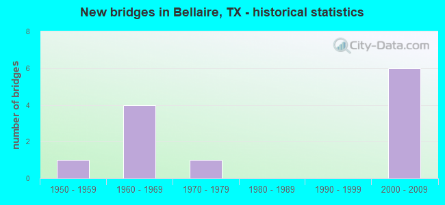
- New bridges - historical statistics
- 11950-1959
- 41960-1969
- 11970-1979
- 62000-2009

- Reconstructed bridges - Historical Statistics
- 21990-1999
- 02000-2009
- 12010-2019


- Bridge Condition - Deck
- 42.9%Good
- 57.1%Satisfactory

- Bridge Condition - Superstructure
- 42.9%Good
- 57.1%Satisfactory

- Bridge Condition - Substructure
- 71.4%Good
- 28.6%Satisfactory
Find on map >> Show street view
Structure Number: 121020027117321, Location: 1.9 MI S OF US 59 (Lat: 29.698592, Lng: -95.459256), Route carried "on" structure: Interstate 610, Year Built: 1967, Year Reconstructed: 2001, Status: Open, Structure Length: 4.88m (16.01ft), Average Daily Traffic: 98,366 (year 2019), Truck Traffic: 5%, Average Future Daily Traffic: 123,640 (year 2033), Design Load: HS 20, Features Intersected: EVERGREEN ST
Minimum Vertical Clearance: 30+ m (98+ ft), Kilometerpoint: 51.436, Lanes on structure: 5, Lanes under structure: 6, Owner: State Highway Agency, Approaching Roadway Width: 24.4m (80.1ft), Material/Design: Concrete continuous, Design/Construction: Slab, Number Of Spans In Main Unit: 3, Length of Maximum Span: 18.3m (60.0ft), Curb-To-Curb Width: 24.4m (80.1ft), Out-to-Out Width: 25.5m (83.7ft)
Condition: Deck: Satisfactory, Superstructure: Satisfactory, Substructure: Satisfactory, Operating Rating: 44.4 metric tons, Method Used To Determine Operating Rating: Assigned ratings based on Allowable Stress Design (ASD) reported in metric tons, Inventory Rating: 32.7 metric tons, Method Used To Determine Inventory Rating: Assigned ratings based on Allowable Stress Design (ASD) reported in metric tons, Structural Evaluation: Equal to present minimum criteria, Deck Geometry: Equal to present minimum criteria, Underclear: Meets minimum limits, Approach Roadway Alignment: Equal to present desirable criteria, Designated Inspection Frequency: Every 24 months, Inspection Date: August 2020, Deck Structure Type: Concrete Cast-file-Place
Find on map >> Show street view
Structure Number: 121020027117487, Location: 1.9 MI S OF US 59 (Lat: 29.698603, Lng: -95.459033), Route carried "on" structure: Interstate 610, Year Built: 1967, Year Reconstructed: 2001, Status: Open, Structure Length: 4.88m (16.01ft), Average Daily Traffic: 90,504 (year 2019), Truck Traffic: 5%, Average Future Daily Traffic: 123,640 (year 2033), Design Load: HS 20, Features Intersected: EVERGREEN ST
Minimum Vertical Clearance: 30+ m (98+ ft), Kilometerpoint: 51.436, Lanes on structure: 5, Lanes under structure: 6, Owner: State Highway Agency, Approaching Roadway Width: 27.1m (88.9ft), Material/Design: Concrete continuous, Design/Construction: Slab, Number Of Spans In Main Unit: 3, Length of Maximum Span: 18.3m (60.0ft), Curb-To-Curb Width: 27.0m (88.6ft), Out-to-Out Width: 27.5m (90.2ft)
Condition: Deck: Satisfactory, Superstructure: Satisfactory, Substructure: Satisfactory, Operating Rating: 44.4 metric tons, Method Used To Determine Operating Rating: Assigned ratings based on Allowable Stress Design (ASD) reported in metric tons, Inventory Rating: 32.7 metric tons, Method Used To Determine Inventory Rating: Assigned ratings based on Allowable Stress Design (ASD) reported in metric tons, Structural Evaluation: Equal to present minimum criteria, Deck Geometry: Superior to present desirable criteria, Underclear: Meets minimum limits, Approach Roadway Alignment: Equal to present desirable criteria, Length Of Structure Improvement: 4.88m (16.01ft), Designated Inspection Frequency: Every 24 months, Inspection Date: August 2020, Bridge Improvement Cost: $218,000, Roadway Improvement Cost: $55,000, Total Project Cost: $273,000, Deck Structure Type: Concrete Cast-file-Place
Find on map >> Show street view
Structure Number: 121020027117511, Location: 0.6 MI S OF US 59 (Lat: 29.716853, Lng: -95.459867), Route carried "on" structure: Interstate 610, Year Built: 2002, Year Reconstructed: 2018, Status: Open, Structure Length: 6.77m (22.21ft), Average Daily Traffic: 173,782 (year 2020), Truck Traffic: 5%, Average Future Daily Traffic: 270,830 (year 2033), Design Load: HS 25 or greater, Features Intersected: FOURNACE PL
Minimum Vertical Clearance: 30+ m (98+ ft), Kilometerpoint: 53.451, Lanes on structure: 11, Lanes under structure: 6, Owner: State Highway Agency, Approaching Roadway Width: 57.3m (188.0ft), Skew: 30 degrees, Material/Design: Prestressed concrete, Design/Construction: Stringer/Multi-beam, Number Of Spans In Main Unit: 3, Length of Maximum Span: 25.0m (82.0ft), Curb-To-Curb Width: 56.5m (185.4ft), Out-to-Out Width: 58.0m (190.3ft)
Condition: Deck: Good, Superstructure: Good, Substructure: Good, Operating Rating: 54.4 metric tons, Method Used To Determine Operating Rating: Assigned rating based on Load Factor Design (LFD) reported in metric tons, Inventory Rating: 32.7 metric tons, Method Used To Determine Inventory Rating: Assigned rating based on Load Factor Design (LFD) reported in metric tons, Structural Evaluation: Better than present minimum criteria, Deck Geometry: Superior to present desirable criteria, Underclear: Equal to present desirable criteria, Approach Roadway Alignment: Equal to present desirable criteria, Designated Inspection Frequency: Every 24 months, Inspection Date: August 2020, Deck Structure Type: Concrete Precast Panels
Find on map >> Show street view
Structure Number: 121020027117512, Location: 1.4 MI S OF US 59 (Lat: 29.706061, Lng: -95.459164), Route carried "on" structure: Interstate 610, Year Built: 2002, Status: Open, Structure Length: 9.45m (31.00ft), Average Daily Traffic: 156,762 (year 2020), Truck Traffic: 5%, Average Future Daily Traffic: 247,280 (year 2033), Design Load: HS 25 or greater, Features Intersected: BELLAIRE BLVD
Minimum Vertical Clearance: 30+ m (98+ ft), Kilometerpoint: 53.438, Lanes on structure: 9, Lanes under structure: 10, Owner: State Highway Agency, Approaching Roadway Width: 45.1m (148.0ft), Skew: 39 degrees, Material/Design: Prestressed concrete, Design/Construction: Stringer/Multi-beam, Number Of Spans In Main Unit: 1, Number Of Approach Spans: 2, Length of Maximum Span: 40.2m (131.9ft), Curb-To-Curb Width: 45.1m (148.0ft), Out-to-Out Width: 46.7m (153.2ft)
Condition: Deck: Good, Superstructure: Good, Substructure: Good, Operating Rating: 54.4 metric tons, Method Used To Determine Operating Rating: Assigned rating based on Load Factor Design (LFD) reported in metric tons, Inventory Rating: 32.7 metric tons, Method Used To Determine Inventory Rating: Assigned rating based on Load Factor Design (LFD) reported in metric tons, Structural Evaluation: Better than present minimum criteria, Deck Geometry: Superior to present desirable criteria, Underclear: Meets minimum limits, Approach Roadway Alignment: Equal to present desirable criteria, Designated Inspection Frequency: Every 24 months, Inspection Date: August 2020, Deck Structure Type: Concrete Precast Panels
Find on map >> Show street view
Structure Number: 121020027117513, Location: 1.0 MI S OF US 59 (Lat: 29.712056, Lng: -95.459903), Route carried "on" structure: Interstate 610, Year Built: 2002, Status: Open, Structure Length: 9.45m (31.00ft), Average Daily Traffic: 173,782 (year 2020), Truck Traffic: 5%, Average Future Daily Traffic: 247,280 (year 2033), Design Load: HS 25 or greater, Features Intersected: BISSONNET ST
Minimum Vertical Clearance: 30+ m (98+ ft), Kilometerpoint: 53.445, Lanes on structure: 11, Lanes under structure: 8, Owner: State Highway Agency, Approaching Roadway Width: 52.4m (171.9ft), Skew: 32 degrees, Material/Design: Prestressed concrete, Design/Construction: Stringer/Multi-beam, Number Of Spans In Main Unit: 1, Number Of Approach Spans: 2, Length of Maximum Span: 39.6m (129.9ft), Curb-To-Curb Width: 52.4m (171.9ft), Out-to-Out Width: 54.0m (177.2ft)
Condition: Deck: Good, Superstructure: Good, Substructure: Good, Operating Rating: 54.4 metric tons, Method Used To Determine Operating Rating: Assigned rating based on Load Factor Design (LFD) reported in metric tons, Inventory Rating: 32.7 metric tons, Method Used To Determine Inventory Rating: Assigned rating based on Load Factor Design (LFD) reported in metric tons, Structural Evaluation: Better than present minimum criteria, Deck Geometry: Superior to present desirable criteria, Underclear: Somewhat better than minimum adequacy, Approach Roadway Alignment: Equal to present desirable criteria, Designated Inspection Frequency: Every 24 months, Inspection Date: August 2020, Deck Structure Type: Concrete Precast Panels
Find on map >> Show street view
Structure Number: 121020B09361058, Location: 0.4 MI W OF STELLA LINK (Lat: 29.689461, Lng: -95.450494), Route carried "on" structure: City street , Year Built: 1959, Status: Open, Structure Length: 3.02m (9.91ft), Average Daily Traffic: 9,610 (year 2010), Average Future Daily Traffic: 16,091 (year 2030), Features Intersected: HCFCD DITCH, Facility Carried by Structure: BEECHNUT ST EB
Minimum Vertical Clearance: 30+ m (98+ ft), Kilometerpoint: 0.966, Lanes on structure: 2, Owner: City or Municipal Highway Agency, Approaching Roadway Width: 7.3m (24.0ft), Skew: 4 degrees, Material/Design: Steel continuous, Design/Construction: Stringer/Multi-beam, Number Of Spans In Main Unit: 3, Length of Maximum Span: 12.2m (40.0ft), Curb or Sidewalk Widths: Left: 0.0m, Right: 0.5m (1.6ft), Curb-To-Curb Width: 7.3m (24.0ft), Out-to-Out Width: 8.5m (27.9ft)
Condition: Deck: Satisfactory, Superstructure: Satisfactory, Substructure: Good, Channel: Good, Operating Rating: 68.0 metric tons, Method Used To Determine Operating Rating: Allowable Stress (AS), Inventory Rating: 40.8 metric tons, Method Used To Determine Inventory Rating: Allowable Stress (AS), Structural Evaluation: Equal to present minimum criteria, Deck Geometry: High priority of replacement, Waterway Adequacy: Equal to present minimum criteria, Approach Roadway Alignment: Equal to present desirable criteria, Length Of Structure Improvement: 3.02m (9.91ft), Designated Inspection Frequency: Every 24 months, Inspection Date: August 2021, Bridge Improvement Cost: $5,000, Roadway Improvement Cost: $1,000, Total Project Cost: $6,000, Deck Structure Type: Concrete Cast-file-Place
Find on map >> Show street view
Structure Number: 121020B46977502, Location: 0.1 MI N OF BEECHNUT ST (Lat: 29.689817, Lng: -95.451108), Route carried "on" structure: City street , Year Built: 1970, Status: Posted for load, Structure Length: 2.19m (7.19ft), Average Daily Traffic: 3,720 (year 2013), Average Future Daily Traffic: 4,836 (year 2033), Features Intersected: HCFCD DITCH, Facility Carried by Structure: NEWCASTLE DR
Minimum Vertical Clearance: 30+ m (98+ ft), Kilometerpoint: 0.161, Lanes on structure: 2, Owner: City or Municipal Highway Agency, Approaching Roadway Width: 7.3m (24.0ft), Skew: 2 degrees, Material/Design: Concrete, Design/Construction: Slab, Number Of Spans In Main Unit: 3, Length of Maximum Span: 7.3m (24.0ft), Curb or Sidewalk Widths: Left: 1.2m (3.9ft), Right: 1.2m (3.9ft), Curb-To-Curb Width: 7.3m (24.0ft), Out-to-Out Width: 10.4m (34.1ft)
Condition: Deck: Satisfactory, Superstructure: Satisfactory, Substructure: Good, Channel: Good, Operating Rating: 32.7 metric tons, Method Used To Determine Operating Rating: Field evaluation and documented engineering judgment, Inventory Rating: 24.5 metric tons, Method Used To Determine Inventory Rating: Field evaluation and documented engineering judgment, Structural Evaluation: Equal to present minimum criteria, Deck Geometry: High priority of replacement, Waterway Adequacy: Better than present minimum criteria, Approach Roadway Alignment: Equal to present desirable criteria, Bridge Posting: Required (Relationship of Operating Rating to Maximum Legal Load: 0.1 - 9.9% below), Length Of Structure Improvement: 2.19m (7.19ft), Designated Inspection Frequency: Every 24 months, Inspection Date: October 2021, Bridge Improvement Cost: $3,000, Roadway Improvement Cost: $1,000, Total Project Cost: $4,000, Deck Structure Type: Concrete Cast-file-Place
Find on map >> Show street view
Structure Number: 121020027117321, Location: 1.9 MI S OF US 59 (Lat: 29.698592, Lng: -95.459256), Route carried "under" structure: City street , Year Built: 1967, Structure Length: 0. m, Average Daily Traffic: 93,320 (year 2011), Truck Traffic: 3%, Features Intersected: EVERGREEN ST, Facility Carried by Structure: IH 610W SB
Minimum Vertical Clearance: 4.72m (15.49ft), Kilometerpoint: 51.436, Lanes on structure: 6, Material/Design: Concrete continuous, Design/Construction: Slab, Length of Maximum Span: 18.3m (60.0ft)
Find on map >> Show street view
Structure Number: 121020027117487, Location: 1.9 MI S OF US 59 (Lat: 29.698603, Lng: -95.459033), Route carried "under" structure: City street , Year Built: 1967, Structure Length: 0. m, Average Daily Traffic: 93,320 (year 2011), Truck Traffic: 3%, Features Intersected: EVERGREEN ST, Facility Carried by Structure: IH 610W NB
Minimum Vertical Clearance: 4.72m (15.49ft), Kilometerpoint: 51.436, Lanes on structure: 6, Material/Design: Concrete continuous, Design/Construction: Slab, Length of Maximum Span: 18.3m (60.0ft)
Find on map >> Show street view
Structure Number: 121020027117511, Location: 0.6 MI S OF US 59 (Lat: 29.716853, Lng: -95.459867), Route carried "under" structure: City street , Year Built: 2002, Structure Length: 0. m, Average Daily Traffic: 5,000 (year 2009), Truck Traffic: 15%, Features Intersected: FOURNACE PL, Facility Carried by Structure: IH 610W
Minimum Vertical Clearance: 5.54m (18.18ft), Kilometerpoint: 52.883, Lanes on structure: 6, Material/Design: Prestressed concrete, Design/Construction: Stringer/Multi-beam, Length of Maximum Span: 25.0m (82.0ft)
Find on map >> Show street view
Structure Number: 121020027117512, Location: 1.4 MI S OF US 59 (Lat: 29.706061, Lng: -95.459164), Route carried "under" structure: City street , Year Built: 2002, Structure Length: 0. m, Average Daily Traffic: 10,000 (year 2009), Truck Traffic: 15%, Features Intersected: BELLAIRE BLVD, Facility Carried by Structure: IH 610W
Minimum Vertical Clearance: 5.36m (17.59ft), Kilometerpoint: 0.003, Lanes on structure: 10, Material/Design: Prestressed concrete, Design/Construction: Stringer/Multi-beam, Length of Maximum Span: 40.2m (131.9ft)
Find on map >> Show street view
Structure Number: 121020027117513, Location: 1.0 MI S OF US 59 (Lat: 29.712056, Lng: -95.459903), Route carried "under" structure: City street , Year Built: 2002, Structure Length: 0. m, Average Daily Traffic: 10,000 (year 2009), Truck Traffic: 15%, Features Intersected: BISSONNET ST, Facility Carried by Structure: IH 610W
Minimum Vertical Clearance: 5.74m (18.83ft), Kilometerpoint: 52.883, Lanes on structure: 8, Material/Design: Prestressed concrete, Design/Construction: Stringer/Multi-beam, Length of Maximum Span: 39.6m (129.9ft)