Bridge Statistics for Athol, Massachusetts (MA)
Condition, Traffic, Stress, Structural Evaluation, Project Costs
- National Bridge Inventory (NBI) Statistics
- 26Number of bridges
- 210ft / 63.9mTotal length
- $31,382,000Total costs
- 154,971Total average daily traffic
- 12,466Total average daily truck traffic
- 182,798Total future (year 2031) average daily traffic
- National Bridge Inventory (NBI) Registered Bridges for Athol
- No street view available for this location
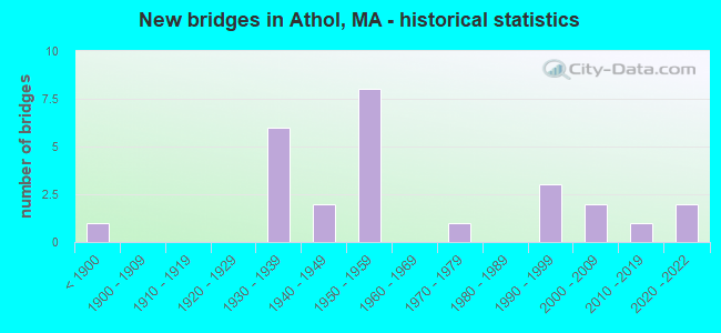
- New bridges - historical statistics
- 1Before 1900
- 61930-1939
- 21940-1949
- 81950-1959
- 11970-1979
- 31990-1999
- 22000-2009
- 12010-2019
- 22020-2022

- Reconstructed bridges - Historical Statistics
- 11950-1959
- 01960-1969
- 11970-1979
- 01980-1989
- 11990-1999
- 22000-2009
- 12010-2019
- 12020-2022


- Bridge Condition - Deck
- 5.0%Excellent
- 15.0%Very good
- 25.0%Good
- 15.0%Satisfactory
- 30.0%Fair
- 5.0%Poor
- 5.0%Serious

- Bridge Condition - Superstructure
- 8.7%Excellent
- 8.7%Very good
- 21.7%Good
- 30.4%Satisfactory
- 21.7%Fair
- 8.7%Poor

- Bridge Condition - Substructure
- 4.3%Excellent
- 4.3%Very good
- 39.1%Good
- 21.7%Satisfactory
- 30.4%Fair

- Bridge Condition - Channel
- 26.3%Very good
- 31.6%Good
- 26.3%Satisfactory
- 15.8%Fair

- Bridge Condition - Culverts
- 66.7%Good
- 33.3%Fair
Find on map >> Show street view
Structure Number: A1500418DMUNNBI, Location: .15M SO.OF WASHINGTON AVE (Lat: 42.529547, Lng: -72.262047), Route carried "on" structure: City street , Year Built: 1979, Status: Open, Structure Length: 1.12m (3.67ft), Average Daily Traffic: 387 (year 2018), Truck Traffic: 6%, Average Future Daily Traffic: 1,022 (year 2031), Features Intersected: WATER S ATHOL PND OUTLET, Facility Carried by Structure: HWY MORGAN AVE
Minimum Vertical Clearance: 30+ m (98+ ft), Kilometerpoint: 0.113, Lanes on structure: 2, Owner: Town or Township Highway Agency, Approaching Roadway Width: 5.5m (18.0ft), Skew: 5 degrees, Material/Design: Steel, Design/Construction: Culvert, Number Of Spans In Main Unit: 2, Length of Maximum Span: 5.2m (17.1ft), Curb-To-Curb Width: 5.5m (18.0ft), Out-to-Out Width: 7.0m (23.0ft)
Condition: Channel: Very good, Culverts: Good, Operating Rating: 52.8 metric tons, Method Used To Determine Operating Rating: Load Factor (LF), Inventory Rating: 31.6 metric tons, Method Used To Determine Inventory Rating: Load Factor (LF), Structural Evaluation: Better than present minimum criteria, Deck Geometry: High priority of corrective action, Waterway Adequacy: Better than present minimum criteria, Approach Roadway Alignment: Equal to present minimum criteria, Length Of Structure Improvement: 1.00m (3.28ft), Designated Inspection Frequency: Every 24 months, Inspection Date: July 2020, Bridge Improvement Cost: $265,000, Roadway Improvement Cost: $27,000, Total Project Cost: $398,000 ( Estimate for 2022)
Find on map >> Show street view
Structure Number: A15005BYRMUNNBI, Location: .05M W OF SO. ATHOL ROAD (Lat: 42.531336, Lng: -72.260642), Route carried "on" structure: City street , Year Built: 2020, Status: Open, Structure Length: 1.48m (4.86ft), Average Daily Traffic: 129 (year 2021), Truck Traffic: 6%, Design Load: HL 93, Features Intersected: WATER S ATHOL PND OUTLET, Facility Carried by Structure: HWY WASHNGTN AVE
Minimum Vertical Clearance: 30+ m (98+ ft), Kilometerpoint: 0.016, Lanes on structure: 2, Owner: Town or Township Highway Agency, Approaching Roadway Width: 6.7m (22.0ft), Material/Design: Prestressed concrete, Design/Construction: Slab, Number Of Spans In Main Unit: 1, Length of Maximum Span: 14.3m (46.9ft), Curb or Sidewalk Widths: Left: 1.7m (5.6ft), Right: 0.0m, Curb-To-Curb Width: 6.7m (22.0ft), Out-to-Out Width: 9.2m (30.2ft)
Condition: Deck: Excellent, Superstructure: Excellent, Substructure: Excellent, Channel: Good, Operating Rating: 42.1 metric tons, Method Used To Determine Operating Rating: Assigned ratings based on Load and Resistance Factor Design (LRFD) reported by rating factor (RF) using HL93 loadings, Inventory Rating: 32.4 metric tons, Method Used To Determine Inventory Rating: Assigned ratings based on Load and Resistance Factor Design (LRFD) reported by rating factor (RF) using HL93 loadings, Structural Evaluation: Equal to present desirable criteria, Deck Geometry: High priority of corrective action, Waterway Adequacy: Better than present minimum criteria, Approach Roadway Alignment: Equal to present desirable criteria, Designated Inspection Frequency: Every 24 months, Inspection Date: May 2021, Deck Structure Type: Concrete Cast-file-Place, Wearing Surface/Protective System: Wearing Surface: Bituminous, Membrane: Other
Find on map >> Show street view
Structure Number: A15006AYNDOTNBI, Location: WEST END OF DWNTWN MAIN S (Lat: 42.592894, Lng: -72.239131), Route carried "on" structure: Alternate State highway 2, Year Built: 2010, Status: Open, Structure Length: 4.02m (13.19ft), Average Daily Traffic: 26,250 (year 2018), Truck Traffic: 4%, Average Future Daily Traffic: 16,267 (year 2031), Design Load: HS 25 or greater, Features Intersected: WATER MILLERS RIVER
Minimum Vertical Clearance: 30+ m (98+ ft), Kilometerpoint: 99.294, Lanes on structure: 2, Base Highway Network: Yes, Owner: State Highway Agency, Approaching Roadway Width: 12.0m (39.4ft), Material/Design: Steel, Design/Construction: Box Beam or Girders - Single/Spread, Number Of Spans In Main Unit: 1, Length of Maximum Span: 39.0m (128.0ft), Curb or Sidewalk Widths: Left: 1.8m (5.9ft), Right: 1.8m (5.9ft), Curb-To-Curb Width: 12.1m (39.7ft), Out-to-Out Width: 16.4m (53.8ft)
Condition: Deck: Very good, Superstructure: Very good, Substructure: Good, Channel: Very good, Inventory Rating: 89.1 metric tons, Method Used To Determine Inventory Rating: Load Factor (LF), Structural Evaluation: Better than present minimum criteria, Deck Geometry: Somewhat better than minimum adequacy, Waterway Adequacy: Better than present minimum criteria, Approach Roadway Alignment: Better than present minimum criteria, Length Of Structure Improvement: 4.10m (13.45ft), Designated Inspection Frequency: Every 24 months, Inspection Date: October 2020, Bridge Improvement Cost: $503,000, Roadway Improvement Cost: $51,000, Total Project Cost: $755,000 ( Estimate for 2022), Deck Structure Type: Concrete Cast-file-Place, Wearing Surface/Protective System: Wearing Surface: Bituminous, Membrane: Preformed Fabric, Deck Protection: Epoxy Coated Reinforcing
Find on map >> Show street view
Structure Number: A1500716FMUNNBI, Location: 0.3M N OF S. MAIN ST. (Lat: 42.596703, Lng: -72.231781), Route carried "on" structure: City street , Year Built: 1939, Year Reconstructed: 2020, Status: Posted for load, Structure Length: 4.62m (15.16ft), Average Daily Traffic: 7,500 (year 2015), Truck Traffic: 6%, Average Future Daily Traffic: 15,793 (year 2032), Features Intersected: WATER MILLERS RIVER, Facility Carried by Structure: HWY EXCHANGE ST
Minimum Vertical Clearance: 4.31m (14.14ft), Kilometerpoint: 0.483, Lanes on structure: 2, Owner: Town or Township Highway Agency, Approaching Roadway Width: 11.2m (36.7ft), Skew: 1 degrees, Material/Design: Steel, Design/Construction: Truss - Thru, Number Of Spans In Main Unit: 1, Length of Maximum Span: 45.7m (149.9ft), Curb or Sidewalk Widths: Left: 1.2m (3.9ft), Right: 1.2m (3.9ft), Curb-To-Curb Width: 11.3m (37.1ft), Out-to-Out Width: 11.7m (38.4ft)
Condition: Deck: Good, Superstructure: Good, Substructure: Good, Channel: Good, Operating Rating: 34.4 metric tons, Method Used To Determine Operating Rating: Load Factor (LF), Inventory Rating: 20.6 metric tons, Method Used To Determine Inventory Rating: Load Factor (LF), Structural Evaluation: Somewhat better than minimum adequacy, Deck Geometry: Meets minimum limits, Waterway Adequacy: Equal to present desirable criteria, Approach Roadway Alignment: Equal to present desirable criteria, Designated Inspection Frequency: Every 24 months, Critical Feature Inspection Frequency: Every 24 months, Inspection Date: May 2020, Critical Feature Inspection Date: May 2020, Deck Structure Type: Concrete Cast-file-Place, Wearing Surface/Protective System: Wearing Surface: Bituminous, Membrane: Built-up
Find on map >> Show street view
Structure Number: A15008C1DMUNNBI, Location: CRECENT ST/MILLERS RIVER (Lat: 42.594458, Lng: -72.226908), Route carried "on" structure: City street , Year Built: 2020, Status: Open, Structure Length: 2.40m (7.87ft), Average Daily Traffic: 4,333 (year 2015), Truck Traffic: 6%, Design Load: HL 93, Features Intersected: WATER MILLERS RIVER, Facility Carried by Structure: HWY CRESCENT ST
Minimum Vertical Clearance: 30+ m (98+ ft), Kilometerpoint: 0.080, Lanes on structure: 2, Owner: Town or Township Highway Agency, Approaching Roadway Width: 11.6m (38.1ft), Material/Design: Prestressed concrete, Design/Construction: Box Beam or Girders - Single/Spread, Number Of Spans In Main Unit: 1, Length of Maximum Span: 23.0m (75.5ft), Curb or Sidewalk Widths: Left: 1.7m (5.6ft), Right: 1.7m (5.6ft), Curb-To-Curb Width: 9.1m (29.9ft), Out-to-Out Width: 13.4m (44.0ft)
Condition: Deck: Very good, Superstructure: Excellent, Substructure: Very good, Channel: Very good, Operating Rating: 42.1 metric tons, Method Used To Determine Operating Rating: Assigned ratings based on Load and Resistance Factor Design (LRFD) reported by rating factor (RF) using HL93 loadings, Inventory Rating: 32.4 metric tons, Method Used To Determine Inventory Rating: Assigned ratings based on Load and Resistance Factor Design (LRFD) reported by rating factor (RF) using HL93 loadings, Structural Evaluation: Equal to present desirable criteria, Deck Geometry: Meets minimum limits, Waterway Adequacy: Equal to present desirable criteria, Approach Roadway Alignment: Equal to present desirable criteria, Designated Inspection Frequency: Every 24 months, Inspection Date: December 2020, Deck Structure Type: Concrete Cast-file-Place, Wearing Surface/Protective System: Wearing Surface: Bituminous, Membrane: Epoxy, Deck Protection: Epoxy Coated Reinforcing
Find on map >> Show street view
Structure Number: A15009BPPMUNNBI, Location: 0.2 M N OF RTE. 2A (Lat: 42.596933, Lng: -72.220453), Route carried "on" structure: State highway 32, Year Built: 1850, Year Reconstructed: 1998, Status: Posted for load, Structure Length: 3.39m (11.12ft), Average Daily Traffic: 2,716 (year 2000), Truck Traffic: 9%, Design Load: HS 20, Features Intersected: WATER MILLERS RIVER
Minimum Vertical Clearance: 30+ m (98+ ft), Kilometerpoint: 0.225, Lanes on structure: 2, Owner: Town or Township Highway Agency, Approaching Roadway Width: 7.4m (24.3ft), Material/Design: Steel, Design/Construction: Truss - Thru, Number Of Spans In Main Unit: 1, Length of Maximum Span: 33.5m (109.9ft), Curb or Sidewalk Widths: Left: 1.4m (4.6ft), Right: 0.0m, Curb-To-Curb Width: 7.4m (24.3ft), Out-to-Out Width: 8.2m (26.9ft)
Condition: Deck: Satisfactory, Superstructure: Satisfactory, Substructure: Fair, Channel: Satisfactory, Operating Rating: 49.1 metric tons, Method Used To Determine Operating Rating: Load Factor (LF), Inventory Rating: 29.4 metric tons, Method Used To Determine Inventory Rating: Load Factor (LF), Structural Evaluation: Somewhat better than minimum adequacy, Deck Geometry: High priority of replacement, Waterway Adequacy: Equal to present desirable criteria, Approach Roadway Alignment: High priority of corrective action, Length Of Structure Improvement: 3.40m (11.15ft), Designated Inspection Frequency: Every 24 months, Critical Feature Inspection Frequency: Every 24 months, Underwater Inspection Frequency: Every 36 months, Inspection Date: December 2020, Critical Feature Inspection Date: December 2020, Underwater Inspection Date: October 2020, Bridge Improvement Cost: $1,096,000, Roadway Improvement Cost: $110,000, Total Project Cost: $1,645,000 ( Estimate for 2022), Deck Structure Type: Steel plate, Wearing Surface/Protective System: Wearing Surface: Other
Find on map >> Show street view
Structure Number: A15012ADBDOT634, Location: 100' N JCT ST 2A & ST 32 (Lat: 42.595808, Lng: -72.221281), Route carried "on" structure: State highway 32, Year Built: 1995, Status: Posted for load, Structure Length: 3.17m (10.40ft), Average Daily Traffic: 6,000 (year 2019), Truck Traffic: 5%, Average Future Daily Traffic: 2,655 (year 2032), Design Load: HS 20, Features Intersected: RR BMRR
Minimum Vertical Clearance: 30+ m (98+ ft), Kilometerpoint: 82.200, Lanes on structure: 2, Owner: State Highway Agency, Approaching Roadway Width: 7.3m (24.0ft), Material/Design: Steel, Design/Construction: Truss - Thru, Number Of Spans In Main Unit: 1, Length of Maximum Span: 30.7m (100.7ft), Curb or Sidewalk Widths: Left: 0.0m, Right: 1.4m (4.6ft), Curb-To-Curb Width: 7.2m (23.6ft), Out-to-Out Width: 7.6m (24.9ft)
Condition: Deck: Fair, Superstructure: Satisfactory, Substructure: Good, Operating Rating: 54.1 metric tons, Method Used To Determine Operating Rating: Load Factor (LF), Inventory Rating: 32.4 metric tons, Method Used To Determine Inventory Rating: Load Factor (LF), Structural Evaluation: Equal to present minimum criteria, Deck Geometry: High priority of replacement, Underclear: High priority of corrective action, Approach Roadway Alignment: Equal to present minimum criteria, Length Of Structure Improvement: 3.20m (10.50ft), Designated Inspection Frequency: Every 24 months, Critical Feature Inspection Frequency: Every 24 months, Inspection Date: December 2021, Critical Feature Inspection Date: December 2021, Bridge Improvement Cost: $2,635,000, Roadway Improvement Cost: $264,000, Total Project Cost: $3,953,000 ( Estimate for 2022), Deck Structure Type: Steel plate, Wearing Surface/Protective System: Wearing Surface: Epoxy Overlay
Find on map >> Show street view
Structure Number: A150131B2DOT634, Location: .1 M W JCT CHSNT HILL RD. (Lat: 42.594875, Lng: -72.224625), Route carried "on" structure: Alternate State highway 2, Year Built: 1938, Status: Open, Structure Length: 2.55m (8.37ft), Average Daily Traffic: 10,649 (year 2017), Truck Traffic: 4%, Average Future Daily Traffic: 13,887 (year 2031), Design Load: H 20, Features Intersected: RR BMRR
Minimum Vertical Clearance: 30+ m (98+ ft), Kilometerpoint: 40.876, Lanes on structure: 2, Base Highway Network: Yes, Owner: State Highway Agency, Approaching Roadway Width: 9.1m (29.9ft), Skew: 5 degrees, Material/Design: Steel, Design/Construction: Girder and Floorbeam System, Number Of Spans In Main Unit: 1, Length of Maximum Span: 25.1m (82.3ft), Curb or Sidewalk Widths: Left: 2.1m (6.9ft), Right: 2.1m (6.9ft), Curb-To-Curb Width: 9.1m (29.9ft), Out-to-Out Width: 10.4m (34.1ft)
Condition: Deck: Fair, Superstructure: Poor, Substructure: Satisfactory, Operating Rating: 56.8 metric tons, Method Used To Determine Operating Rating: Load Factor (LF), Inventory Rating: 34.0 metric tons, Method Used To Determine Inventory Rating: Load Factor (LF), Structural Evaluation: Meets minimum limits, Deck Geometry: High priority of corrective action, Underclear: High priority of corrective action, Approach Roadway Alignment: Better than present minimum criteria, Length Of Structure Improvement: 2.60m (8.53ft), Designated Inspection Frequency: Every 12 months, Critical Feature Inspection Frequency: Every 24 months, Other Special Inspection Frequency: Every 12 months, Inspection Date: September 2020, Critical Feature Inspection Date: September 2020, Other Special Inspection Date: September 2021, Bridge Improvement Cost: $1,063,000, Roadway Improvement Cost: $107,000, Total Project Cost: $1,595,000 ( Estimate for 2022), Deck Structure Type: Concrete Cast-file-Place, Wearing Surface/Protective System: Wearing Surface: Bituminous, Membrane: Built-up
Find on map >> Show street view
Structure Number: A150151B1DOT634, Location: 1.5 M N JCT ORANGE T.L. (Lat: 42.580244, Lng: -72.257114), Route carried "on" structure: State highway , Year Built: 1990, Status: Open, Structure Length: 5.33m (17.49ft), Average Daily Traffic: 15,000 (year 2020), Truck Traffic: 6%, Average Future Daily Traffic: 4,493 (year 2033), Design Load: HS 20, Features Intersected: RR PANAM, Facility Carried by Structure: HWY DAN SHAY HWY
Minimum Vertical Clearance: 30+ m (98+ ft), Kilometerpoint: 2.253, Lanes on structure: 2, Base Highway Network: Yes, Owner: State Highway Agency, Approaching Roadway Width: 12.2m (40.0ft), Skew: 4 degrees, Material/Design: Steel continuous, Design/Construction: Stringer/Multi-beam, Number Of Spans In Main Unit: 3, Length of Maximum Span: 20.7m (67.9ft), Curb or Sidewalk Widths: Left: 0.3m (1.0ft), Right: 1.5m (4.9ft), Curb-To-Curb Width: 12.2m (40.0ft), Out-to-Out Width: 14.8m (48.6ft)
Condition: Deck: Good, Superstructure: Satisfactory, Substructure: Satisfactory, Operating Rating: 68.2 metric tons, Method Used To Determine Operating Rating: Load Factor (LF), Inventory Rating: 40.9 metric tons, Method Used To Determine Inventory Rating: Load Factor (LF), Structural Evaluation: Equal to present minimum criteria, Deck Geometry: Somewhat better than minimum adequacy, Underclear: Better than present minimum criteria, Approach Roadway Alignment: Equal to present desirable criteria, Length Of Structure Improvement: 5.40m (17.72ft), Designated Inspection Frequency: Every 24 months, Inspection Date: March 2020, Bridge Improvement Cost: $611,000, Roadway Improvement Cost: $62,000, Total Project Cost: $917,000 ( Estimate for 2022), Deck Structure Type: Concrete Cast-file-Place, Wearing Surface/Protective System: Wearing Surface: Bituminous, Membrane: Built-up, Deck Protection: Epoxy Coated Reinforcing
Find on map >> Show street view
Structure Number: A1501618GMUNNBI, Location: ATHOL/ORANGE TOWN LINE (Lat: 42.614481, Lng: -72.238303), Route carried "on" structure: City street , Year Built: 1937, Status: Posted for load, Structure Length: 1.69m (5.54ft), Average Daily Traffic: 1,293 (year 2017), Truck Traffic: 6%, Average Future Daily Traffic: 2,655 (year 2032), Design Load: H 20, Features Intersected: WATER E BR TULLY RIVER, Facility Carried by Structure: HWY PINEDALE AVE
Minimum Vertical Clearance: 30+ m (98+ ft), Kilometerpoint: 0.016, Lanes on structure: 2, Owner: Town or Township Highway Agency, Approaching Roadway Width: 7.3m (24.0ft), Material/Design: Steel, Design/Construction: Stringer/Multi-beam, Number Of Spans In Main Unit: 1, Length of Maximum Span: 15.7m (51.5ft), Curb or Sidewalk Widths: Left: 0.2m (0.7ft), Right: 0.2m (0.7ft), Curb-To-Curb Width: 7.3m (24.0ft), Out-to-Out Width: 8.7m (28.5ft)
Condition: Deck: Serious, Superstructure: Fair, Substructure: Fair, Channel: Good, Operating Rating: 2.7 metric tons, Method Used To Determine Operating Rating: Load Factor (LF), Inventory Rating: 2.7 metric tons, Method Used To Determine Inventory Rating: Load Factor (LF), Structural Evaluation: High priority of corrective action, Deck Geometry: Meets minimum limits, Waterway Adequacy: Meets minimum limits, Approach Roadway Alignment: Equal to present minimum criteria, Bridge Posting: Required (Relationship of Operating Rating to Maximum Legal Load: > 39.9% below), Length Of Structure Improvement: 1.70m (5.58ft), Designated Inspection Frequency: Every 6 months, Underwater Inspection Frequency: Every 36 months, Other Special Inspection Frequency: Every 6 months, Inspection Date: May 2021, Underwater Inspection Date: Febuary 2020, Other Special Inspection Date: November 2021, Bridge Improvement Cost: $581,000, Roadway Improvement Cost: $59,000, Total Project Cost: $872,000 ( Estimate for 2022), Deck Structure Type: Concrete Cast-file-Place, Wearing Surface/Protective System: Wearing Surface: Bituminous, Membrane: Other
Find on map >> Show street view
Structure Number: A1501718BMUNNBI, Location: 0.1MI W. OF RTE. 32 (Lat: 42.629364, Lng: -72.226208), Route carried "on" structure: City street , Year Built: 1937, Status: Posted for load, Structure Length: 1.55m (5.09ft), Average Daily Traffic: 2,328 (year 2017), Truck Traffic: 6%, Average Future Daily Traffic: 816 (year 2032), Design Load: H 15, Features Intersected: WATER E BR TULLY RIVER, Facility Carried by Structure: HWY LOGAN RD
Minimum Vertical Clearance: 30+ m (98+ ft), Kilometerpoint: 0.016, Lanes on structure: 2, Owner: Town or Township Highway Agency, Approaching Roadway Width: 7.3m (24.0ft), Material/Design: Steel, Design/Construction: Stringer/Multi-beam, Number Of Spans In Main Unit: 1, Length of Maximum Span: 14.3m (46.9ft), Curb or Sidewalk Widths: Left: 0.2m (0.7ft), Right: 0.2m (0.7ft), Curb-To-Curb Width: 7.3m (24.0ft), Out-to-Out Width: 8.5m (27.9ft)
Condition: Deck: Fair, Superstructure: Fair, Substructure: Fair, Channel: Satisfactory, Operating Rating: 40.0 metric tons, Method Used To Determine Operating Rating: Load Factor (LF), Inventory Rating: 23.9 metric tons, Method Used To Determine Inventory Rating: Load Factor (LF), Structural Evaluation: Somewhat better than minimum adequacy, Deck Geometry: High priority of replacement, Waterway Adequacy: Equal to present desirable criteria, Approach Roadway Alignment: Somewhat better than minimum adequacy, Length Of Structure Improvement: 1.60m (5.25ft), Designated Inspection Frequency: Every 24 months, Underwater Inspection Frequency: Every 36 months, Inspection Date: October 2021, Underwater Inspection Date: Febuary 2020, Bridge Improvement Cost: $535,000, Roadway Improvement Cost: $54,000, Total Project Cost: $803,000 ( Estimate for 2022), Deck Structure Type: Concrete Cast-file-Place, Wearing Surface/Protective System: Wearing Surface: Bituminous
Find on map >> Show street view
Structure Number: A1501818TDOTNBI, Location: 1500' W OF BROOKSIDE RD (Lat: 42.582864, Lng: -72.260756), Route carried "on" structure: Alternate State highway 2, Year Built: 1930, Status: Open, Structure Length: 0.91m (2.99ft), Average Daily Traffic: 8,704 (year 2017), Truck Traffic: 4%, Average Future Daily Traffic: 14,909 (year 2031), Features Intersected: WATER WEST BROOK
Minimum Vertical Clearance: 30+ m (98+ ft), Kilometerpoint: 37.175, Lanes on structure: 2, Base Highway Network: Yes, Owner: State Highway Agency, Approaching Roadway Width: 9.8m (32.2ft), Skew: 4 degrees, Material/Design: Concrete, Design/Construction: Slab, Number Of Spans In Main Unit: 1, Length of Maximum Span: 8.0m (26.2ft), Curb-To-Curb Width: 9.8m (32.2ft), Out-to-Out Width: 18.9m (62.0ft)
Condition: Deck: Poor, Superstructure: Poor, Substructure: Fair, Channel: Fair, Operating Rating: 97.6 metric tons, Method Used To Determine Operating Rating: Load Factor (LF), Inventory Rating: 58.8 metric tons, Method Used To Determine Inventory Rating: Load Factor (LF), Structural Evaluation: Meets minimum limits, Deck Geometry: Meets minimum limits, Waterway Adequacy: Better than present minimum criteria, Approach Roadway Alignment: Better than present minimum criteria, Length Of Structure Improvement: 1.00m (3.28ft), Designated Inspection Frequency: Every 12 months, Underwater Inspection Frequency: Every 36 months, Other Special Inspection Frequency: Every 12 months, Inspection Date: May 2020, Underwater Inspection Date: July 2021, Other Special Inspection Date: May 2021, Bridge Improvement Cost: $743,000, Roadway Improvement Cost: $75,000, Total Project Cost: $1,115,000 ( Estimate for 2022), Deck Structure Type: Concrete Cast-file-Place, Wearing Surface/Protective System: Wearing Surface: Bituminous
Find on map >> Show street view
Structure Number: A1502019UDOTNBI, Location: 1.0 M N JCT ORANGE T.L. (Lat: 42.575922, Lng: -72.260814), Route carried "on" structure: US , Year Built: 1935, Status: Open, Structure Length: 5.17m (16.96ft), Average Daily Traffic: 6,002 (year 2016), Truck Traffic: 9%, Average Future Daily Traffic: 9,599 (year 2032), Design Load: H 20, Features Intersected: WATER MILLERS RIVER, Facility Carried by Structure: HWY DANIEL SHAYS
Minimum Vertical Clearance: 30+ m (98+ ft), Kilometerpoint: 96.558, Lanes on structure: 2, Base Highway Network: Yes, Owner: State Highway Agency, Approaching Roadway Width: 12.2m (40.0ft), Skew: 2 degrees, Material/Design: Concrete continuous, Design/Construction: Tee Beam, Number Of Spans In Main Unit: 7, Length of Maximum Span: 7.3m (24.0ft), Curb or Sidewalk Widths: Left: 0.2m (0.7ft), Right: 1.5m (4.9ft), Curb-To-Curb Width: 12.2m (40.0ft), Out-to-Out Width: 14.9m (48.9ft)
Condition: Deck: Fair, Superstructure: Fair, Substructure: Fair, Channel: Satisfactory, Operating Rating: 69.0 metric tons, Method Used To Determine Operating Rating: Load Factor (LF), Inventory Rating: 45.1 metric tons, Method Used To Determine Inventory Rating: Load Factor (LF), Structural Evaluation: Somewhat better than minimum adequacy, Deck Geometry: Somewhat better than minimum adequacy, Waterway Adequacy: Equal to present desirable criteria, Approach Roadway Alignment: Equal to present desirable criteria, Length Of Structure Improvement: 5.20m (17.06ft), Designated Inspection Frequency: Every 24 months, Underwater Inspection Frequency: Every 36 months, Inspection Date: April 2021, Underwater Inspection Date: August 2019, Bridge Improvement Cost: $3,044,000, Roadway Improvement Cost: $305,000, Total Project Cost: $4,567,000 ( Estimate for 2022), Deck Structure Type: Concrete Cast-file-Place, Wearing Surface/Protective System: Wearing Surface: Monolithic Concrete
Find on map >> Show street view
Structure Number: A1502119TDOTNBI, Location: .3 M N JCT ORANGE T.L. (Lat: 42.569414, Lng: -72.272344), Route carried "on" structure: US , Year Built: 1955, Status: Open, Structure Length: 2.15m (7.05ft), Average Daily Traffic: 4,075 (year 2016), Truck Traffic: 6%, Average Future Daily Traffic: 8,577 (year 2031), Design Load: H 20, Features Intersected: WATER LAKE ROHNTA OUTLET, Facility Carried by Structure: HWY DANIEL SHAYS
Minimum Vertical Clearance: 30+ m (98+ ft), Kilometerpoint: 95.271, Lanes on structure: 2, Base Highway Network: Yes, Owner: State Highway Agency, Approaching Roadway Width: 13.4m (44.0ft), Skew: 3 degrees, Material/Design: Steel, Design/Construction: Stringer/Multi-beam, Number Of Spans In Main Unit: 1, Length of Maximum Span: 20.2m (66.3ft), Curb or Sidewalk Widths: Left: 0.4m (1.3ft), Right: 0.9m (3.0ft), Curb-To-Curb Width: 13.4m (44.0ft), Out-to-Out Width: 15.5m (50.9ft)
Condition: Deck: Fair, Superstructure: Satisfactory, Substructure: Satisfactory, Channel: Satisfactory, Operating Rating: 35.0 metric tons, Method Used To Determine Operating Rating: Allowable Stress (AS), Inventory Rating: 18.0 metric tons, Method Used To Determine Inventory Rating: Allowable Stress (AS), Structural Evaluation: Somewhat better than minimum adequacy, Deck Geometry: Better than present minimum criteria, Waterway Adequacy: Equal to present desirable criteria, Approach Roadway Alignment: Equal to present desirable criteria, Length Of Structure Improvement: 2.20m (7.22ft), Designated Inspection Frequency: Every 24 months, Inspection Date: October 2020, Bridge Improvement Cost: $1,340,000, Roadway Improvement Cost: $135,000, Total Project Cost: $2,011,000 ( Estimate for 2022), Deck Structure Type: Concrete Cast-file-Place, Wearing Surface/Protective System: Wearing Surface: Monolithic Concrete
Find on map >> Show street view
Structure Number: A150225YBMUNNBI, Location: 0.1 M S OF KING ST (Lat: 42.550800, Lng: -72.263603), Route carried "on" structure: City street , Year Built: 2004, Status: Open, Structure Length: 0.98m (3.22ft), Average Daily Traffic: 517 (year 2019), Truck Traffic: 4%, Design Load: HS 25 or greater, Features Intersected: WATER WHITE POND OUT, Facility Carried by Structure: HWY WHITE POND
Minimum Vertical Clearance: 30+ m (98+ ft), Kilometerpoint: 0.000, Lanes on structure: 2, Owner: Town or Township Highway Agency, Approaching Roadway Width: 9.7m (31.8ft), Material/Design: Concrete, Design/Construction: Frame, Number Of Spans In Main Unit: 1, Length of Maximum Span: 9.8m (32.2ft), Curb-To-Curb Width: 9.7m (31.8ft), Out-to-Out Width: 10.7m (35.1ft)
Condition: Superstructure: Good, Substructure: Good, Channel: Good, Inventory Rating: 76.7 metric tons, Method Used To Determine Inventory Rating: Load Factor (LF), Structural Evaluation: Better than present minimum criteria, Deck Geometry: Equal to present minimum criteria, Waterway Adequacy: Equal to present desirable criteria, Approach Roadway Alignment: Equal to present desirable criteria, Length Of Structure Improvement: 1.00m (3.28ft), Designated Inspection Frequency: Every 24 months, Inspection Date: January 2021, Bridge Improvement Cost: $236,000, Roadway Improvement Cost: $24,000, Total Project Cost: $355,000 ( Estimate for 2022), Wearing Surface/Protective System: Wearing Surface: Bituminous
Find on map >> Show street view
Structure Number: A1503019LDOTNBI, Location: MM 71.3 ON RT 2 (Lat: 42.562583, Lng: -72.274167), Route carried "on" structure: State highway 2, Year Built: 1955, Year Reconstructed: 2010, Status: Open, Structure Length: 1.72m (5.64ft), Average Daily Traffic: 11,683 (year 2018), Truck Traffic: 8%, Average Future Daily Traffic: 13,478 (year 2032), Design Load: HS 25 or greater, Features Intersected: WATER LAKE ROHUNTA
Minimum Vertical Clearance: 30+ m (98+ ft), Kilometerpoint: 114.703, Lanes on structure: 2, Base Highway Network: Yes, Owner: State Highway Agency, Approaching Roadway Width: 15.0m (49.2ft), Material/Design: Prestressed concrete, Design/Construction: Box Beam or Girders - Single/Spread, Number Of Spans In Main Unit: 1, Length of Maximum Span: 16.0m (52.5ft), Curb-To-Curb Width: 15.0m (49.2ft), Out-to-Out Width: 16.0m (52.5ft)
Condition: Deck: Very good, Superstructure: Very good, Substructure: Good, Channel: Very good, Operating Rating: 61.1 metric tons, Method Used To Determine Operating Rating: Load Factor (LF), Inventory Rating: 36.6 metric tons, Method Used To Determine Inventory Rating: Load Factor (LF), Structural Evaluation: Better than present minimum criteria, Deck Geometry: Superior to present desirable criteria, Waterway Adequacy: Equal to present desirable criteria, Approach Roadway Alignment: Equal to present desirable criteria, Length Of Structure Improvement: 1.80m (5.91ft), Designated Inspection Frequency: Every 24 months, Underwater Inspection Frequency: Every 36 months, Inspection Date: July 2021, Underwater Inspection Date: April 2021, Bridge Improvement Cost: $340,000, Roadway Improvement Cost: $35,000, Total Project Cost: $511,000 ( Estimate for 2022), Deck Structure Type: Concrete Cast-file-Place, Wearing Surface/Protective System: Wearing Surface: Bituminous, Membrane: Preformed Fabric, Deck Protection: Epoxy Coated Reinforcing
Find on map >> Show street view
Structure Number: A150311ADDOTNBI, Location: PLEASANT ST/US 202 & ST 2 (Lat: 42.566072, Lng: -72.218858), Route carried "on" structure: City street , Year Built: 1954, Status: Open, Structure Length: 4.95m (16.24ft), Average Daily Traffic: 1,940 (year 2014), Truck Traffic: 6%, Average Future Daily Traffic: 409 (year 2031), Design Load: H 20, Features Intersected: US202 /ST2, Facility Carried by Structure: HWY PLEASANT ST
Minimum Vertical Clearance: 30+ m (98+ ft), Kilometerpoint: 0.000, Lanes on structure: 2, Lanes under structure: 2, Owner: State Highway Agency, Approaching Roadway Width: 12.2m (40.0ft), Skew: 1 degrees, Material/Design: Steel continuous, Design/Construction: Stringer/Multi-beam, Number Of Spans In Main Unit: 3, Length of Maximum Span: 18.7m (61.4ft), Curb or Sidewalk Widths: Left: 0.5m (1.6ft), Right: 1.7m (5.6ft), Curb-To-Curb Width: 12.2m (40.0ft), Out-to-Out Width: 15.0m (49.2ft)
Condition: Deck: Satisfactory, Superstructure: Fair, Substructure: Satisfactory, Operating Rating: 46.5 metric tons, Method Used To Determine Operating Rating: Allowable Stress (AS), Inventory Rating: 29.6 metric tons, Method Used To Determine Inventory Rating: Allowable Stress (AS), Structural Evaluation: Somewhat better than minimum adequacy, Deck Geometry: Better than present minimum criteria, Underclear: High priority of corrective action, Approach Roadway Alignment: Equal to present desirable criteria, Length Of Structure Improvement: 5.00m (16.40ft), Designated Inspection Frequency: Every 24 months, Inspection Date: October 2020, Bridge Improvement Cost: $2,947,000, Roadway Improvement Cost: $295,000, Total Project Cost: $4,421,000 ( Estimate for 2022), Deck Structure Type: Concrete Cast-file-Place, Wearing Surface/Protective System: Wearing Surface: Latex Concrete
Find on map >> Show street view
Structure Number: A1503219MDOTNBI, Location: 1.3M W. OF PHILLIPSTON TL (Lat: 42.570719, Lng: -72.201069), Route carried "on" structure: State highway 2, Year Built: 1956, Year Reconstructed: 1983, Status: Open, Structure Length: 3.66m (12.01ft), Average Daily Traffic: 1,491 (year 2016), Truck Traffic: 5%, Average Future Daily Traffic: 21,794 (year 2031), Design Load: H 20, Features Intersected: ST 32 PETERSHAM RD
Minimum Vertical Clearance: 30+ m (98+ ft), Kilometerpoint: 121.068, Lanes on structure: 2, Lanes under structure: 2, Base Highway Network: Yes, Owner: State Highway Agency, Approaching Roadway Width: 14.3m (46.9ft), Skew: 6 degrees, Material/Design: Steel, Design/Construction: Stringer/Multi-beam, Number Of Spans In Main Unit: 1, Length of Maximum Span: 34.0m (111.5ft), Curb-To-Curb Width: 14.4m (47.2ft), Out-to-Out Width: 15.3m (50.2ft)
Condition: Deck: Satisfactory, Superstructure: Satisfactory, Substructure: Fair, Operating Rating: 65.9 metric tons, Method Used To Determine Operating Rating: Load Factor (LF), Inventory Rating: 39.5 metric tons, Method Used To Determine Inventory Rating: Load Factor (LF), Structural Evaluation: Somewhat better than minimum adequacy, Deck Geometry: Superior to present desirable criteria, Underclear: Meets minimum limits, Approach Roadway Alignment: Equal to present desirable criteria, Length Of Structure Improvement: 3.70m (12.14ft), Designated Inspection Frequency: Every 24 months, Inspection Date: November 2020, Bridge Improvement Cost: $2,224,000, Roadway Improvement Cost: $223,000, Total Project Cost: $3,337,000 ( Estimate for 2022), Deck Structure Type: Concrete Cast-file-Place, Wearing Surface/Protective System: Wearing Surface: Latex Concrete, Deck Protection: Bituminous
Find on map >> Show street view
Structure Number: A1503319QDOTNBI, Location: MM 71.7 ON ST 2 (Lat: 42.565083, Lng: -72.265378), Route carried "on" structure: State highway 2, Year Built: 1954, Year Reconstructed: 2012, Status: Open, Structure Length: 2.28m (7.48ft), Average Daily Traffic: 12,802 (year 2019), Truck Traffic: 19%, Average Future Daily Traffic: 17,320 (year 2032), Design Load: HS 25 or greater, Features Intersected: HWY WHITE POND RD
Minimum Vertical Clearance: 30+ m (98+ ft), Kilometerpoint: 115.900, Lanes on structure: 2, Lanes under structure: 2, Base Highway Network: Yes, Owner: State Highway Agency, Approaching Roadway Width: 15.0m (49.2ft), Skew: 3 degrees, Material/Design: Steel, Design/Construction: Stringer/Multi-beam, Number Of Spans In Main Unit: 1, Length of Maximum Span: 21.3m (69.9ft), Curb-To-Curb Width: 15.0m (49.2ft), Out-to-Out Width: 16.0m (52.5ft)
Condition: Deck: Good, Superstructure: Good, Substructure: Good, Operating Rating: 92.4 metric tons, Method Used To Determine Operating Rating: Load Factor (LF), Inventory Rating: 55.3 metric tons, Method Used To Determine Inventory Rating: Load Factor (LF), Structural Evaluation: Better than present minimum criteria, Deck Geometry: Superior to present desirable criteria, Underclear: High priority of corrective action, Approach Roadway Alignment: Equal to present desirable criteria, Length Of Structure Improvement: 2.30m (7.55ft), Designated Inspection Frequency: Every 24 months, Inspection Date: Febuary 2021, Bridge Improvement Cost: $145,000, Roadway Improvement Cost: $15,000, Total Project Cost: $218,000 ( Estimate for 2022), Deck Structure Type: Concrete Cast-file-Place, Wearing Surface/Protective System: Wearing Surface: Bituminous, Membrane: Preformed Fabric, Deck Protection: Epoxy Coated Reinforcing
Find on map >> Show street view
Structure Number: A1503419PDOTNBI, Location: MM 72.7 ON ST 2 (Lat: 42.563508, Lng: -72.247067), Route carried "on" structure: State highway 2, Year Built: 1954, Year Reconstructed: 2012, Status: Open, Structure Length: 1.97m (6.46ft), Average Daily Traffic: 12,802 (year 2019), Truck Traffic: 19%, Average Future Daily Traffic: 21,478 (year 2033), Design Load: HS 25 or greater, Features Intersected: HWY S ATHOL RD
Minimum Vertical Clearance: 30+ m (98+ ft), Kilometerpoint: 117.036, Lanes on structure: 2, Lanes under structure: 2, Base Highway Network: Yes, Owner: State Highway Agency, Approaching Roadway Width: 15.0m (49.2ft), Skew: 2 degrees, Material/Design: Steel, Design/Construction: Stringer/Multi-beam, Number Of Spans In Main Unit: 1, Length of Maximum Span: 18.3m (60.0ft), Curb-To-Curb Width: 15.0m (49.2ft), Out-to-Out Width: 16.0m (52.5ft)
Condition: Deck: Good, Superstructure: Good, Substructure: Good, Inventory Rating: 75.6 metric tons, Method Used To Determine Inventory Rating: Load Factor (LF), Structural Evaluation: Better than present minimum criteria, Deck Geometry: Superior to present desirable criteria, Underclear: High priority of corrective action, Approach Roadway Alignment: Equal to present desirable criteria, Length Of Structure Improvement: 2.00m (6.56ft), Designated Inspection Frequency: Every 24 months, Inspection Date: Febuary 2021, Bridge Improvement Cost: $126,000, Roadway Improvement Cost: $13,000, Total Project Cost: $190,000 ( Estimate for 2022), Deck Structure Type: Concrete Cast-file-Place, Wearing Surface/Protective System: Wearing Surface: Bituminous, Membrane: Preformed Fabric, Deck Protection: Epoxy Coated Reinforcing
Find on map >> Show street view
Structure Number: A1503519NDOTNBI, Location: MM 74.7 ON RT 2 (Lat: 42.567886, Lng: -72.210897), Route carried "on" structure: State highway 2, Year Built: 1954, Status: Open, Structure Length: 1.52m (4.99ft), Average Daily Traffic: 14,910 (year 2018), Truck Traffic: 9%, Average Future Daily Traffic: 13,887 (year 2032), Design Load: H 20, Features Intersected: WATER LAKE ELLIS
Minimum Vertical Clearance: 30+ m (98+ ft), Kilometerpoint: 120.094, Lanes on structure: 2, Base Highway Network: Yes, Owner: State Highway Agency, Approaching Roadway Width: 12.2m (40.0ft), Material/Design: Concrete continuous, Design/Construction: Culvert, Number Of Spans In Main Unit: 3, Length of Maximum Span: 4.9m (16.1ft)
Condition: Channel: Fair, Culverts: Fair, Operating Rating: 51.8 metric tons, Method Used To Determine Operating Rating: Load Factor (LF), Inventory Rating: 32.4 metric tons, Method Used To Determine Inventory Rating: Load Factor (LF), Structural Evaluation: Somewhat better than minimum adequacy, Waterway Adequacy: Better than present minimum criteria, Approach Roadway Alignment: Equal to present desirable criteria, Length Of Structure Improvement: 1.30m (4.27ft), Designated Inspection Frequency: Every 24 months, Underwater Inspection Frequency: Every 36 months, Inspection Date: July 2021, Underwater Inspection Date: April 2019, Bridge Improvement Cost: $777,000, Roadway Improvement Cost: $78,000, Total Project Cost: $1,166,000 ( Estimate for 2022), Wearing Surface/Protective System: Wearing Surface: Bituminous, Membrane: Built-up
Find on map >> Show street view
Structure Number: A1504518FMUNNBI, Location: BETWN RT2A&S.ATHOL RD (Lat: 42.591636, Lng: -72.236606), Route carried "on" structure: City street , Year Built: 1993, Status: Open, Structure Length: 0.67m (2.20ft), Average Daily Traffic: 259 (year 2020), Average Future Daily Traffic: 1,022 (year 2033), Design Load: HS 20, Features Intersected: WATER MILL BROOK, Facility Carried by Structure: HWY CANAL ST
Minimum Vertical Clearance: 30+ m (98+ ft), Kilometerpoint: 0.032, Lanes on structure: 2, Owner: Town or Township Highway Agency, Approaching Roadway Width: 7.3m (24.0ft), Skew: 1 degrees, Material/Design: Concrete, Design/Construction: Culvert, Number Of Spans In Main Unit: 2, Length of Maximum Span: 3.1m (10.2ft), Curb or Sidewalk Widths: Left: 1.5m (4.9ft), Right: 0.3m (1.0ft), Curb-To-Curb Width: 7.3m (24.0ft), Out-to-Out Width: 10.0m (32.8ft)
Condition: Channel: Fair, Culverts: Good, Operating Rating: 99.7 metric tons, Method Used To Determine Operating Rating: Allowable Stress (AS), Inventory Rating: 59.7 metric tons, Method Used To Determine Inventory Rating: Allowable Stress (AS), Structural Evaluation: Better than present minimum criteria, Deck Geometry: Somewhat better than minimum adequacy, Waterway Adequacy: Equal to present desirable criteria, Approach Roadway Alignment: Equal to present desirable criteria, Length Of Structure Improvement: 0.40m (1.31ft), Designated Inspection Frequency: Every 24 months, Inspection Date: March 2020, Bridge Improvement Cost: $247,000, Roadway Improvement Cost: $25,000, Total Project Cost: $371,000 ( Estimate for 2022)
Find on map >> Show street view
Structure Number: CEPNEDMA2510009, Location: 4.8 KM NORTH OF ATHOL (Lat: 42.638331, Lng: -72.224039), Route carried "on" structure: ServiceFederal lands road , Year Built: 1948, Status: Open, Structure Length: 2.06m (6.76ft), Average Daily Traffic: 1,000 (year 2016), Truck Traffic: 2%, Average Future Daily Traffic: 500 (year 2040), Design Load: H 15, Features Intersected: SPILLWAY CHANNEL, Facility Carried by Structure: MA ROUTE 32
Minimum Vertical Clearance: 30+ m (98+ ft), Kilometerpoint: 0.000, Lanes on structure: 2, Owner: Corps of Engineers (Civil), Approaching Roadway Width: 6.7m (22.0ft), Material/Design: Concrete, Design/Construction: Arch - Deck, Number Of Spans In Main Unit: 1, Length of Maximum Span: 20.6m (67.6ft), Curb or Sidewalk Widths: Left: 0.9m (3.0ft), Right: 0.9m (3.0ft), Curb-To-Curb Width: 6.7m (22.0ft), Out-to-Out Width: 8.5m (27.9ft)
Condition: Superstructure: Satisfactory, Substructure: Fair, Channel: Very good, Operating Rating: 97.2 metric tons, Method Used To Determine Operating Rating: Load and Resistance Factor Rating (LRFR) rating reported by rating factor(RF) method using HL-93 loadings, Inventory Rating: 83.6 metric tons, Method Used To Determine Inventory Rating: Load and Resistance Factor Rating (LRFR) rating reported by rating factor(RF) method using HL-93 loadings, Structural Evaluation: Somewhat better than minimum adequacy, Deck Geometry: Meets minimum limits, Waterway Adequacy: Superior to present desirable criteria, Approach Roadway Alignment: Equal to present minimum criteria, Length Of Structure Improvement: 4.02m (13.19ft), Designated Inspection Frequency: Every 24 months, Inspection Date: September 2020, Bridge Improvement Cost: $249,000, Roadway Improvement Cost: $1,000, Total Project Cost: $250,000 ( Estimate for 2020), Deck Structure Type: Concrete Cast-file-Place
Find on map >> Show street view
Structure Number: CEPNEDMA251001, Location: 1.609 KM N OF TULLY LAKE (Lat: 42.650631, Lng: -72.208464), Route carried "on" structure: ServiceFederal lands road , Year Built: 1944, Year Reconstructed: 1950, Status: Posted for load, Structure Length: 1.63m (5.35ft), Average Daily Traffic: 200 (year 2021), Truck Traffic: 5%, Average Future Daily Traffic: 300 (year 2039), Design Load: H 15, Features Intersected: TULLY RIVER, Facility Carried by Structure: DOANE HILL ROAD
Minimum Vertical Clearance: 30+ m (98+ ft), Kilometerpoint: 0.000, Lanes on structure: 2, Owner: Corps of Engineers (Civil), Approaching Roadway Width: 7.3m (24.0ft), Material/Design: Steel, Design/Construction: Stringer/Multi-beam, Number Of Spans In Main Unit: 1, Length of Maximum Span: 15.0m (49.2ft), Curb or Sidewalk Widths: Left: 0.4m (1.3ft), Right: 0.4m (1.3ft), Curb-To-Curb Width: 7.3m (24.0ft), Out-to-Out Width: 8.2m (26.9ft)
Condition: Deck: Good, Superstructure: Satisfactory, Substructure: Good, Channel: Good, Operating Rating: 26.3 metric tons, Method Used To Determine Operating Rating: Allowable Stress (AS), Inventory Rating: 13.0 metric tons, Method Used To Determine Inventory Rating: Allowable Stress (AS), Structural Evaluation: Meets minimum limits, Deck Geometry: Somewhat better than minimum adequacy, Waterway Adequacy: Better than present minimum criteria, Approach Roadway Alignment: Better than present minimum criteria, Length Of Structure Improvement: 3.19m (10.47ft), Designated Inspection Frequency: Every 24 months, Inspection Date: July 2021, Bridge Improvement Cost: $1,000, Roadway Improvement Cost: $1,000, Total Project Cost: $2,000 ( Estimate for 2017), Deck Structure Type: Concrete Cast-file-Place, Wearing Surface/Protective System: Wearing Surface: Bituminous, Membrane: Preformed Fabric
Find on map >> Show street view
Structure Number: O03003AMPMUNNBI, Location: 0.3M WEST OF TULLY RD (Lat: 42.635289, Lng: -72.251708), Route carried "on" structure: City street , Year Built: 2001, Status: Open, Structure Length: 0.87m (2.85ft), Average Daily Traffic: 450 (year 2005), Truck Traffic: 1%, Average Future Daily Traffic: 711 (year 2032), Design Load: HS 20, Features Intersected: WATER W BR TULLY RIVER, Facility Carried by Structure: HWY ROYALSTON RD
Minimum Vertical Clearance: 30+ m (98+ ft), Kilometerpoint: 0.966, Lanes on structure: 2, Owner: Town or Township Highway Agency, Approaching Roadway Width: 6.0m (19.7ft), Skew: 1 degrees, Material/Design: Concrete, Design/Construction: Frame, Number Of Spans In Main Unit: 1, Length of Maximum Span: 8.1m (26.6ft), Curb or Sidewalk Widths: Left: 0.0m, Right: 1.5m (4.9ft), Curb-To-Curb Width: 6.0m (19.7ft), Out-to-Out Width: 8.4m (27.6ft)
Condition: Superstructure: Good, Substructure: Good, Channel: Good, Operating Rating: 95.4 metric tons, Method Used To Determine Operating Rating: Load Factor (LF), Inventory Rating: 63.0 metric tons, Method Used To Determine Inventory Rating: Load Factor (LF), Structural Evaluation: Better than present minimum criteria, Deck Geometry: High priority of replacement, Waterway Adequacy: Equal to present desirable criteria, Approach Roadway Alignment: Equal to present desirable criteria, Length Of Structure Improvement: 0.90m (2.95ft), Designated Inspection Frequency: Every 24 months, Underwater Inspection Frequency: Every 24 months, Inspection Date: November 2021, Underwater Inspection Date: June 2021, Bridge Improvement Cost: $527,000, Roadway Improvement Cost: $53,000, Total Project Cost: $791,000 ( Estimate for 2022), Wearing Surface/Protective System: Wearing Surface: Bituminous, Membrane: Preformed Fabric, Deck Protection: Epoxy Coated Reinforcing
Find on map >> Show street view
Structure Number: O030040TVMUNNBI, Location: 1100' S INT CREAMERY RD (Lat: 42.645744, Lng: -72.256703), Route carried "on" structure: City street , Year Built: 1954, Status: Posted for load, Structure Length: 2.07m (6.79ft), Average Daily Traffic: 1,551 (year 2019), Truck Traffic: 5%, Average Future Daily Traffic: 1,226 (year 2032), Design Load: H 20, Features Intersected: WATER W BR TULLY RIVER, Facility Carried by Structure: HWY TULLY RD
Minimum Vertical Clearance: 30+ m (98+ ft), Kilometerpoint: 3.701, Lanes on structure: 2, Owner: Town or Township Highway Agency, Approaching Roadway Width: 7.9m (25.9ft), Material/Design: Concrete continuous, Design/Construction: Slab, Number Of Spans In Main Unit: 4, Length of Maximum Span: 5.0m (16.4ft), Curb or Sidewalk Widths: Left: 0.3m (1.0ft), Right: 0.3m (1.0ft), Curb-To-Curb Width: 7.9m (25.9ft), Out-to-Out Width: 9.2m (30.2ft)
Condition: Deck: Fair, Superstructure: Fair, Substructure: Satisfactory, Channel: Satisfactory, Operating Rating: 40.6 metric tons, Method Used To Determine Operating Rating: Load Factor (LF), Inventory Rating: 24.3 metric tons, Method Used To Determine Inventory Rating: Load Factor (LF), Structural Evaluation: Somewhat better than minimum adequacy, Deck Geometry: Meets minimum limits, Waterway Adequacy: Better than present minimum criteria, Approach Roadway Alignment: Better than present minimum criteria, Length Of Structure Improvement: 2.10m (6.89ft), Designated Inspection Frequency: Every 24 months, Underwater Inspection Frequency: Every 36 months, Inspection Date: January 2021, Underwater Inspection Date: April 2020, Bridge Improvement Cost: $759,000, Roadway Improvement Cost: $76,000, Total Project Cost: $1,139,000 ( Estimate for 2022), Deck Structure Type: Concrete Cast-file-Place, Wearing Surface/Protective System: Wearing Surface: Bituminous