Bridge Statistics for Ashland, Wisconsin (WI)
Condition, Traffic, Stress, Structural Evaluation, Project Costs
- National Bridge Inventory (NBI) Statistics
- 14Number of bridges
- 36ft / 10.7mTotal length
- $435,000Total costs
- 34,088Total average daily traffic
- 575Total average daily truck traffic
- National Bridge Inventory (NBI) Registered Bridges for Ashland
- No street view available for this location
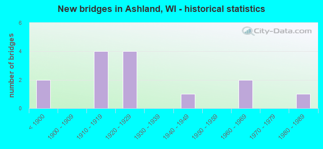
- New bridges - historical statistics
- 2Before 1900
- 41910-1919
- 41920-1929
- 11940-1949
- 21960-1969
- 11980-1989

- Reconstructed bridges - Historical Statistics
- 11960-1969
- 01970-1979
- 11980-1989
- 11990-1999


- Bridge Condition - Deck
- 40.0%Good
- 20.0%Satisfactory
- 20.0%Fair
- 20.0%Poor

- Bridge Condition - Superstructure
- 60.0%Good
- 20.0%Fair
- 20.0%Poor

- Bridge Condition - Substructure
- 20.0%Good
- 40.0%Satisfactory
- 20.0%Fair
- 20.0%Poor

- Bridge Condition - Channel
- 33.3%Very good
- 33.3%Good
- 33.3%Satisfactory
Find on map >> Show street view
Structure Number: F328, Location: 7 KM EAST OF ASHLAND (Lat: 46.582953, Lng: -90.796631), Route carried "on" structure: Federal lands road 19, Year Built: 1981, Status: Open, Structure Length: 2.19m (7.19ft), Average Daily Traffic: 300 (year 2020), Truck Traffic: 15%, Average Future Daily Traffic: 400 (year 2040), Design Load: HS 20+Mod, Features Intersected: BEAR TRAP CREEK
Minimum Vertical Clearance: 30+ m (98+ ft), Kilometerpoint: 6.440, Lanes on structure: 2, Owner: Bureau of Indian Affairs, Approaching Roadway Width: 6.9m (22.6ft), Material/Design: Prestressed concrete, Design/Construction: Stringer/Multi-beam, Number Of Spans In Main Unit: 1, Length of Maximum Span: 21.3m (69.9ft), Curb-To-Curb Width: 9.1m (29.9ft), Out-to-Out Width: 9.8m (32.2ft)
Condition: Deck: Good, Superstructure: Good, Substructure: Good, Channel: Good, Operating Rating: 57.1 metric tons, Method Used To Determine Operating Rating: Load Factor (LF), Inventory Rating: 26.1 metric tons, Method Used To Determine Inventory Rating: Load Factor (LF), Structural Evaluation: Equal to present minimum criteria, Deck Geometry: Equal to present minimum criteria, Waterway Adequacy: Equal to present minimum criteria, Approach Roadway Alignment: Better than present minimum criteria, Designated Inspection Frequency: Every 24 months, Inspection Date: September 2020, Deck Structure Type: Concrete Cast-file-Place, Wearing Surface/Protective System: Wearing Surface: Monolithic Concrete
Find on map >> Show street view
Structure Number: B020011, Location: 0.6M E JCT STH 13 TO S (Lat: 46.597611, Lng: -90.873392), Route carried "on" structure: US 2, Year Built: 1969, Status: Open, Structure Length: 0.73m (2.40ft), Average Daily Traffic: 15,400 (year 2019), Truck Traffic: 3%, Average Future Daily Traffic: 18,500 (year 2039), Design Load: H 20, Features Intersected: BAY CITY CREEK
Minimum Vertical Clearance: 30+ m (98+ ft), Kilometerpoint: 0.000, Lanes on structure: 4, Base Highway Network: Yes, Owner: City or Municipal Highway Agency, Approaching Roadway Width: 19.5m (64.0ft), Skew: 2 degrees, Material/Design: Concrete continuous, Design/Construction: Culvert, Number Of Spans In Main Unit: 2, Length of Maximum Span: 3.0m (9.8ft)
Condition: Channel: Satisfactory, Culverts: Good, Operating Rating: 53.9 metric tons, Method Used To Determine Operating Rating: Field evaluation and documented engineering judgment, Inventory Rating: 24.3 metric tons, Method Used To Determine Inventory Rating: Field evaluation and documented engineering judgment, Structural Evaluation: Equal to present minimum criteria, Waterway Adequacy: Equal to present desirable criteria, Approach Roadway Alignment: Equal to present desirable criteria, Designated Inspection Frequency: Every 24 months, Inspection Date: August 2020, Deck Structure Type: Concrete Cast-file-Place, Wearing Surface/Protective System: Wearing Surface: Bituminous
Find on map >> Show street view
Structure Number: B020414, Location: 3.7M N JCT CTH E (Lat: 46.497619, Lng: -90.909214), Route carried "on" structure: State highway 112, Year Built: 1926, Year Reconstructed: 1985, Status: Open, Structure Length: 2.23m (7.32ft), Average Daily Traffic: 1,700 (year 2019), Truck Traffic: 4%, Average Future Daily Traffic: 2,220 (year 2040), Design Load: HS 20, Features Intersected: WHITE RIVER
Minimum Vertical Clearance: 30+ m (98+ ft), Kilometerpoint: 0.000, Lanes on structure: 2, Owner: State Highway Agency, Approaching Roadway Width: 10.4m (34.1ft), Material/Design: Prestressed concrete continuous, Design/Construction: Stringer/Multi-beam, Number Of Spans In Main Unit: 1, Length of Maximum Span: 22.3m (73.2ft), Curb-To-Curb Width: 10.4m (34.1ft), Out-to-Out Width: 11.3m (37.1ft)
Condition: Deck: Fair, Superstructure: Good, Substructure: Satisfactory, Channel: Very good, Operating Rating: 58.8 metric tons, Method Used To Determine Operating Rating: Load Factor (LF), Inventory Rating: 29.2 metric tons, Method Used To Determine Inventory Rating: Load Factor (LF), Structural Evaluation: Equal to present minimum criteria, Deck Geometry: Equal to present minimum criteria, Waterway Adequacy: Equal to present desirable criteria, Approach Roadway Alignment: Equal to present minimum criteria, Designated Inspection Frequency: Every 24 months, Underwater Inspection Frequency: Every 60 months, Inspection Date: October 2021, Underwater Inspection Date: November 2021, Deck Structure Type: Concrete Cast-file-Place, Wearing Surface/Protective System: Wearing Surface: Monolithic Concrete, Deck Protection: Epoxy Coated Reinforcing
Find on map >> Show street view
Structure Number: B020423, Location: 6.0M N JCT STH 77 (Lat: 46.268972, Lng: -90.840083), Route carried "on" structure: County highway , Year Built: 1948, Year Reconstructed: 1960, Status: Open, Structure Length: 0.69m (2.26ft), Average Daily Traffic: 534 (year 2019), Average Future Daily Traffic: 587 (year 2040), Design Load: H 15, Features Intersected: MCCARTHY CREEK, Facility Carried by Structure: CTH GG
Minimum Vertical Clearance: 30+ m (98+ ft), Kilometerpoint: 0.000, Lanes on structure: 2, Owner: County Highway Agency, Approaching Roadway Width: 9.8m (32.2ft), Material/Design: Wood or Timber, Design/Construction: Stringer/Multi-beam, Number Of Spans In Main Unit: 1, Length of Maximum Span: 6.3m (20.7ft), Curb-To-Curb Width: 8.5m (27.9ft), Out-to-Out Width: 8.8m (28.9ft)
Condition: Deck: Satisfactory, Superstructure: Poor, Substructure: Fair, Channel: Good, Operating Rating: 42.5 metric tons, Method Used To Determine Operating Rating: Load Factor (LF), Inventory Rating: 29.2 metric tons, Method Used To Determine Inventory Rating: Load Factor (LF), Structural Evaluation: Meets minimum limits, Deck Geometry: Somewhat better than minimum adequacy, Waterway Adequacy: Equal to present desirable criteria, Approach Roadway Alignment: Equal to present desirable criteria, Length Of Structure Improvement: 1.13m (3.71ft), Designated Inspection Frequency: Every 12 months, Inspection Date: August 2021, Bridge Improvement Cost: $108,000, Roadway Improvement Cost: $10,000, Total Project Cost: $162,000 ( Estimate for 2021), Deck Structure Type: Wood or Timber, Wearing Surface/Protective System: Wearing Surface: Bituminous
Find on map >> Show street view
Structure Number: P020707, Location: 0.3M E JCT STH 13 (Lat: 46.327556, Lng: -90.655583), Route carried "on" structure: City street , Year Built: 1920, Status: Posted for load, Structure Length: 1.92m (6.30ft), Average Daily Traffic: 117 (year 2019), Average Future Daily Traffic: 128 (year 2040), Design Load: H 15, Features Intersected: BAD RIVER, Facility Carried by Structure: LRD E TYLER ST
Minimum Vertical Clearance: 30+ m (98+ ft), Kilometerpoint: 0.000, Lanes on structure: 2, Owner: City or Municipal Highway Agency, Approaching Roadway Width: 7.3m (24.0ft), Material/Design: Steel, Design/Construction: Stringer/Multi-beam, Number Of Spans In Main Unit: 2, Length of Maximum Span: 9.0m (29.5ft), Curb or Sidewalk Widths: Left: 2.0m (6.6ft), Right: 0.0m, Curb-To-Curb Width: 6.1m (20.0ft), Out-to-Out Width: 7.7m (25.3ft)
Condition: Deck: Poor, Superstructure: Fair, Substructure: Poor, Channel: Very good, Operating Rating: 27.8 metric tons, Method Used To Determine Operating Rating: Load Factor (LF), Inventory Rating: 16.2 metric tons, Method Used To Determine Inventory Rating: Load Factor (LF), Structural Evaluation: Meets minimum limits, Deck Geometry: Meets minimum limits, Waterway Adequacy: Meets minimum limits, Approach Roadway Alignment: Equal to present desirable criteria, Length Of Structure Improvement: 2.38m (7.81ft), Designated Inspection Frequency: Every 12 months, Inspection Date: August 2021, Bridge Improvement Cost: $182,000, Roadway Improvement Cost: $18,000, Total Project Cost: $273,000 ( Estimate for 2021), Deck Structure Type: Concrete Cast-file-Place, Wearing Surface/Protective System: Wearing Surface: Other
Find on map >> Show street view
Structure Number: P020713, Location: 0.6M E JCT STH 13 (Lat: 46.596028, Lng: -90.873194), Route carried "on" structure: City street , Year Built: 1968, Year Reconstructed: 1997, Status: Open, Structure Length: 2.98m (9.78ft), Average Daily Traffic: 3,807 (year 2019), Average Future Daily Traffic: 4,187 (year 2039), Design Load: HS 20, Features Intersected: BAY CITY CREEK, Facility Carried by Structure: LRD MAIN ST
Minimum Vertical Clearance: 30+ m (98+ ft), Kilometerpoint: 0.000, Lanes on structure: 2, Owner: City or Municipal Highway Agency, Approaching Roadway Width: 11.0m (36.1ft), Material/Design: Prestressed concrete, Design/Construction: Stringer/Multi-beam, Number Of Spans In Main Unit: 3, Length of Maximum Span: 9.8m (32.2ft), Curb or Sidewalk Widths: Left: 2.0m (6.6ft), Right: 0.0m, Curb-To-Curb Width: 10.4m (34.1ft), Out-to-Out Width: 13.0m (42.7ft)
Condition: Deck: Good, Superstructure: Good, Substructure: Satisfactory, Channel: Satisfactory, Operating Rating: 55.5 metric tons, Method Used To Determine Operating Rating: Load Factor (LF), Inventory Rating: 35.6 metric tons, Method Used To Determine Inventory Rating: Load Factor (LF), Structural Evaluation: Equal to present minimum criteria, Deck Geometry: Somewhat better than minimum adequacy, Waterway Adequacy: Equal to present desirable criteria, Approach Roadway Alignment: Equal to present desirable criteria, Designated Inspection Frequency: Every 24 months, Inspection Date: August 2020, Deck Structure Type: Concrete Cast-file-Place, Wearing Surface/Protective System: Wearing Surface: Monolithic Concrete, Deck Protection: Epoxy Coated Reinforcing
Find on map >> Show street view
Structure Number: B020417, Location: 0.3M S JCT USH 2 (Lat: 46.586786, Lng: -90.885836), Route carried "under" structure: City street , Year Built: 1917, Structure Length: 0. m, Average Daily Traffic: 1,300 (year 2018), Features Intersected: LRD VAUGHN AVE, Facility Carried by Structure: CNW RR
Minimum Vertical Clearance: 3.25m (10.66ft), Kilometerpoint: 0.000, Lanes under structure: 2, Material/Design: Steel, Design/Construction: Girder and Floorbeam System, Length of Maximum Span: 17.1m (56.1ft)
Find on map >> Show street view
Structure Number: B020418, Location: 0.3M S JCT USH 2 (Lat: 46.586783, Lng: -90.885867), Route carried "under" structure: City street , Year Built: 1897, Structure Length: 0. m, Average Daily Traffic: 1,300 (year 2018), Features Intersected: LRD VAUGHN AVE, Facility Carried by Structure: BN RR
Minimum Vertical Clearance: 3.35m (10.99ft), Kilometerpoint: 0.000, Lanes under structure: 2, Material/Design: Steel, Design/Construction: Girder and Floorbeam System, Length of Maximum Span: 13.7m (44.9ft)
Find on map >> Show street view
Structure Number: B020419, Location: 0.2M S JCT USH 2 (Lat: 46.586783, Lng: -90.885867), Route carried "under" structure: City street , Year Built: 1896, Structure Length: 0. m, Average Daily Traffic: 1,300 (year 2018), Features Intersected: LRD VAUGHN AVE, Facility Carried by Structure: SOO LINE
Minimum Vertical Clearance: 3.30m (10.83ft), Kilometerpoint: 0.000, Lanes under structure: 2, Material/Design: Steel, Design/Construction: Girder and Floorbeam System, Length of Maximum Span: 13.7m (44.9ft)
Find on map >> Show street view
Structure Number: B02042, Location: 0.2M S JCT USH 2 (Lat: 46.586783, Lng: -90.885867), Route carried "under" structure: City street , Year Built: 1917, Structure Length: 0. m, Average Daily Traffic: 1,300 (year 2018), Features Intersected: LRD VAUGHN AVE, Facility Carried by Structure: CNW RR
Minimum Vertical Clearance: 3.53m (11.58ft), Kilometerpoint: 0.000, Lanes under structure: 2, Material/Design: Steel, Design/Construction: Girder and Floorbeam System, Length of Maximum Span: 13.1m (43.0ft)
Structure Number: P020708, Location: 0.1M N JCT USH 2, Route carried "under" structure: City street , Year Built: 1922, Structure Length: 0. m, Average Daily Traffic: 250 (year 2019), Features Intersected: LRD ST CLAIR ST, Facility Carried by Structure: CNW RR
Minimum Vertical Clearance: 9.14m (29.99ft), Kilometerpoint: 0.000, Lanes under structure: 2, Material/Design: Steel, Design/Construction: Stringer/Multi-beam, Length of Maximum Span: 25.3m (83.0ft)
Minimum Vertical Clearance: 9.14m (29.99ft), Kilometerpoint: 0.000, Lanes under structure: 2, Material/Design: Steel, Design/Construction: Stringer/Multi-beam, Length of Maximum Span: 25.3m (83.0ft)
Structure Number: P020709, Location: 0.2M N JCT USH 2, Route carried "under" structure: City street , Year Built: 1922, Structure Length: 0. m, Average Daily Traffic: 300 (year 2019), Features Intersected: LRD WATER ST, Facility Carried by Structure: SOO LINE
Minimum Vertical Clearance: 12.19m (39.99ft), Kilometerpoint: 0.000, Lanes under structure: 2, Material/Design: Steel, Design/Construction: Stringer/Multi-beam, Length of Maximum Span: 11.1m (36.4ft)
Minimum Vertical Clearance: 12.19m (39.99ft), Kilometerpoint: 0.000, Lanes under structure: 2, Material/Design: Steel, Design/Construction: Stringer/Multi-beam, Length of Maximum Span: 11.1m (36.4ft)
Structure Number: P020712, Location: 0.5M E JCT STH 13, Route carried "under" structure: City street , Year Built: 1910, Structure Length: 0. m, Average Daily Traffic: 3,240 (year 2019), Features Intersected: LRD 2ND ST, Facility Carried by Structure: SOO LINE
Minimum Vertical Clearance: 7.62m (25.00ft), Kilometerpoint: 0.000, Lanes under structure: 2, Material/Design: Steel, Design/Construction: Girder and Floorbeam System, Length of Maximum Span: 13.3m (43.6ft)
Minimum Vertical Clearance: 7.62m (25.00ft), Kilometerpoint: 0.000, Lanes under structure: 2, Material/Design: Steel, Design/Construction: Girder and Floorbeam System, Length of Maximum Span: 13.3m (43.6ft)
Structure Number: P020714, Location: 0.5M E JCT STH 13, Route carried "under" structure: City street , Year Built: 1910, Structure Length: 0. m, Average Daily Traffic: 3,240 (year 2019), Features Intersected: LRD 2ND ST, Facility Carried by Structure: SOO LINE
Minimum Vertical Clearance: 3.83m (12.57ft), Kilometerpoint: 0.000, Lanes under structure: 2, Material/Design: Steel, Design/Construction: Girder and Floorbeam System, Length of Maximum Span: 13.3m (43.6ft)
Minimum Vertical Clearance: 3.83m (12.57ft), Kilometerpoint: 0.000, Lanes under structure: 2, Material/Design: Steel, Design/Construction: Girder and Floorbeam System, Length of Maximum Span: 13.3m (43.6ft)