Bridge Statistics for Aransas Pass, Texas (TX)
Condition, Traffic, Stress, Structural Evaluation, Project Costs
- National Bridge Inventory (NBI) Statistics
- 16Number of bridges
- 804ft / 245mTotal length
- $4,076,000Total costs
- 133,598Total average daily traffic
- 11,891Total average daily truck traffic
- National Bridge Inventory (NBI) Registered Bridges for Aransas Pass
- No street view available for this location
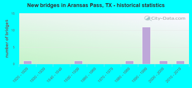
- New bridges - historical statistics
- 11920-1929
- 11950-1959
- 11980-1989
- 111990-1999
- 12000-2009
- 12010-2019


- Bridge Condition - Deck
- 81.8%Good
- 18.2%Fair

- Bridge Condition - Superstructure
- 9.1%Very good
- 45.5%Good
- 27.3%Satisfactory
- 18.2%Fair

- Bridge Condition - Substructure
- 63.6%Good
- 18.2%Satisfactory
- 18.2%Fair

- Bridge Condition - Channel
- 10.0%Very good
- 70.0%Good
- 10.0%Satisfactory
- 10.0%Fair

- Bridge Condition - Culverts
- 50.0%Good
- 50.0%Satisfactory
Find on map >> Show street view
Structure Number: 161780226302004, Location: 0.80 MI SE OF COMMERCIAL (Lat: 27.895347, Lng: -97.131872), Route carried "on" structure: State highway 361, Year Built: 1959, Status: Open, Structure Length: 63.89m (209.61ft), Average Daily Traffic: 6,462 (year 2020), Truck Traffic: 10%, Average Future Daily Traffic: 8,770 (year 2033), Design Load: H 20, Features Intersected: GULF INTRACOASTAL W-WAY
Minimum Vertical Clearance: 30+ m (98+ ft), Kilometerpoint: 0.278, Lanes on structure: 2, Owner: State Highway Agency, Approaching Roadway Width: 12.8m (42.0ft), Navigation Control: Yes ( Vertical Clearance: 15.2m (49.9ft), Horizontal Clearance: 38.1m (125.0ft)), Material/Design: Steel continuous, Design/Construction: Girder and Floorbeam System, Number Of Spans In Main Unit: 3, Number Of Approach Spans: 32, Length of Maximum Span: 45.7m (149.9ft), Curb or Sidewalk Widths: Left: 0.9m (3.0ft), Right: 0.0m, Curb-To-Curb Width: 8.5m (27.9ft), Out-to-Out Width: 10.2m (33.5ft)
Condition: Deck: Good, Superstructure: Satisfactory, Substructure: Satisfactory, Channel: Very good, Operating Rating: 50.8 metric tons, Method Used To Determine Operating Rating: Load Factor (LF), Inventory Rating: 29.9 metric tons, Method Used To Determine Inventory Rating: Load Factor (LF), Structural Evaluation: Equal to present minimum criteria, Deck Geometry: Meets minimum limits, Waterway Adequacy: Equal to present desirable criteria, Approach Roadway Alignment: Equal to present desirable criteria, Length Of Structure Improvement: 64.53m (211.71ft), Designated Inspection Frequency: Every 24 months, Underwater Inspection Frequency: Every 60 months, Inspection Date: August 2020, Underwater Inspection Date: July 2019, Bridge Improvement Cost: $3,261,000, Roadway Improvement Cost: $815,000, Total Project Cost: $4,076,000, Deck Structure Type: Concrete Cast-file-Place, Wearing Surface/Protective System: Wearing Surface: Bituminous
Find on map >> Show street view
Structure Number: 16178022630202, Location: 2.40 MI SE OF COMMERCIAL (Lat: 27.889164, Lng: -97.110583), Route carried "on" structure: State highway 361, Year Built: 1994, Status: Open, Structure Length: 12.65m (41.50ft), Average Daily Traffic: 5,268 (year 2016), Truck Traffic: 10%, Average Future Daily Traffic: 8,770 (year 2033), Design Load: HS 20, Features Intersected: MORRIS & CUMMINGS CUT
Minimum Vertical Clearance: 30+ m (98+ ft), Kilometerpoint: 3.140, Lanes on structure: 2, Owner: State Highway Agency, Approaching Roadway Width: 13.4m (44.0ft), Material/Design: Prestressed concrete, Number Of Spans In Main Unit: 8, Length of Maximum Span: 16.8m (55.1ft), Curb-To-Curb Width: 13.2m (43.3ft), Out-to-Out Width: 14.0m (45.9ft)
Condition: Deck: Good, Superstructure: Satisfactory, Substructure: Fair, Channel: Fair, Operating Rating: 54.4 metric tons, Method Used To Determine Operating Rating: Assigned rating based on Load Factor Design (LFD) reported in metric tons, Inventory Rating: 32.7 metric tons, Method Used To Determine Inventory Rating: Assigned rating based on Load Factor Design (LFD) reported in metric tons, Structural Evaluation: Somewhat better than minimum adequacy, Deck Geometry: Somewhat better than minimum adequacy, Waterway Adequacy: Equal to present minimum criteria, Approach Roadway Alignment: Equal to present desirable criteria, Designated Inspection Frequency: Every 24 months, Underwater Inspection Frequency: Every 24 months, Inspection Date: August 2020, Underwater Inspection Date: September 2020, Deck Structure Type: Concrete Precast Panels
Find on map >> Show street view
Structure Number: 161780226302021, Location: 2.75 MI SE OF COMMERCIAL (Lat: 27.885944, Lng: -97.106364), Route carried "on" structure: State highway 361, Year Built: 1995, Status: Open, Structure Length: 61.57m (202.00ft), Average Daily Traffic: 5,268 (year 2016), Truck Traffic: 10%, Average Future Daily Traffic: 8,770 (year 2033), Design Load: HS 20, Features Intersected: RED FISH BAY
Minimum Vertical Clearance: 30+ m (98+ ft), Kilometerpoint: 3.689, Lanes on structure: 2, Owner: State Highway Agency, Approaching Roadway Width: 13.4m (44.0ft), Material/Design: Prestressed concrete, Number Of Spans In Main Unit: 38, Length of Maximum Span: 16.8m (55.1ft), Curb-To-Curb Width: 13.2m (43.3ft), Out-to-Out Width: 14.0m (45.9ft)
Condition: Deck: Good, Superstructure: Satisfactory, Substructure: Good, Channel: Satisfactory, Operating Rating: 54.4 metric tons, Method Used To Determine Operating Rating: Assigned rating based on Load Factor Design (LFD) reported in metric tons, Inventory Rating: 32.7 metric tons, Method Used To Determine Inventory Rating: Assigned rating based on Load Factor Design (LFD) reported in metric tons, Structural Evaluation: Equal to present minimum criteria, Deck Geometry: Somewhat better than minimum adequacy, Waterway Adequacy: Equal to present minimum criteria, Approach Roadway Alignment: Equal to present desirable criteria, Designated Inspection Frequency: Every 24 months, Underwater Inspection Frequency: Every 24 months, Inspection Date: August 2020, Underwater Inspection Date: October 2020, Deck Structure Type: Concrete Cast-file-Place, Wearing Surface/Protective System: Wearing Surface: Bituminous
Find on map >> Show street view
Structure Number: 161780226302022, Location: AT SAN PAT C/L (Lat: 27.898100, Lng: -97.139850), Route carried "on" structure: State highway 361, Year Built: 2008, Status: Open, Structure Length: 5.49m (18.01ft), Average Daily Traffic: 5,268 (year 2016), Truck Traffic: 10%, Average Future Daily Traffic: 8,770 (year 2033), Design Load: HS 20, Features Intersected: SEAWALL CHANNEL
Minimum Vertical Clearance: 30+ m (98+ ft), Kilometerpoint: 0.018, Lanes on structure: 5, Owner: State Highway Agency, Approaching Roadway Width: 19.2m (63.0ft), Material/Design: Prestressed concrete, Design/Construction: Box Beam or Girders - Multiple, Number Of Spans In Main Unit: 3, Length of Maximum Span: 18.3m (60.0ft), Curb or Sidewalk Widths: Left: 2.7m (8.9ft), Right: 2.7m (8.9ft), Curb-To-Curb Width: 19.2m (63.0ft), Out-to-Out Width: 25.1m (82.3ft)
Condition: Deck: Good, Superstructure: Very good, Substructure: Good, Channel: Good, Operating Rating: 54.4 metric tons, Method Used To Determine Operating Rating: Assigned rating based on Load Factor Design (LFD) reported in metric tons, Inventory Rating: 32.7 metric tons, Method Used To Determine Inventory Rating: Assigned rating based on Load Factor Design (LFD) reported in metric tons, Structural Evaluation: Better than present minimum criteria, Deck Geometry: Meets minimum limits, Waterway Adequacy: Equal to present minimum criteria, Approach Roadway Alignment: Equal to present desirable criteria, Designated Inspection Frequency: Every 24 months, Underwater Inspection Frequency: Every 60 months, Inspection Date: August 2020, Underwater Inspection Date: September 2020, Deck Structure Type: Concrete Precast Panels
Find on map >> Show street view
Structure Number: 161780226302023, Location: 4.75 MI SE OF COMMERCIAL (Lat: 27.865094, Lng: -97.084083), Route carried "on" structure: State highway 361, Year Built: 2010, Status: Open, Structure Length: 46.33m (152.00ft), Average Daily Traffic: 5,268 (year 2016), Truck Traffic: 10%, Average Future Daily Traffic: 8,770 (year 2033), Design Load: HL 93, Features Intersected: RED FISH BAY RELIEF
Minimum Vertical Clearance: 30+ m (98+ ft), Kilometerpoint: 6.886, Lanes on structure: 2, Owner: State Highway Agency, Approaching Roadway Width: 13.4m (44.0ft), Material/Design: Prestressed concrete, Design/Construction: Stringer/Multi-beam, Number Of Spans In Main Unit: 19, Length of Maximum Span: 24.4m (80.1ft), Curb-To-Curb Width: 13.2m (43.3ft), Out-to-Out Width: 14.0m (45.9ft)
Condition: Deck: Good, Superstructure: Good, Substructure: Good, Channel: Good, Operating Rating: 54.4 metric tons, Method Used To Determine Operating Rating: Assigned ratings based on Load and Resistance Factor Design (LRFD) reported in metric tons, Inventory Rating: 32.7 metric tons, Method Used To Determine Inventory Rating: Assigned ratings based on Load and Resistance Factor Design (LRFD) reported in metric tons, Structural Evaluation: Better than present minimum criteria, Deck Geometry: Somewhat better than minimum adequacy, Waterway Adequacy: Superior to present desirable criteria, Approach Roadway Alignment: Equal to present desirable criteria, Designated Inspection Frequency: Every 24 months, Underwater Inspection Frequency: Every 60 months, Inspection Date: August 2020, Underwater Inspection Date: September 2020, Deck Structure Type: Concrete Cast-file-Place
Find on map >> Show street view
Structure Number: 162050018006028, Location: 1.80 MI E OF FM 3512 (Lat: 27.929178, Lng: -97.187403), Route carried "on" structure: State highway 35, Year Built: 1926, Year Reconstructed: 1954, Status: Open, Structure Length: 5.36m (17.59ft), Average Daily Traffic: 8,830 (year 2011), Truck Traffic: 11%, Average Future Daily Traffic: 17,470 (year 2031), Design Load: H 15, Features Intersected: MCCAMPBELL SLOUGH
Minimum Vertical Clearance: 30+ m (98+ ft), Kilometerpoint: 5.121, Lanes on structure: 2, Owner: State Highway Agency, Approaching Roadway Width: 11.6m (38.1ft), Material/Design: Concrete continuous, Design/Construction: Slab, Number Of Spans In Main Unit: 16, Length of Maximum Span: 3.4m (11.2ft), Curb-To-Curb Width: 12.5m (41.0ft), Out-to-Out Width: 13.2m (43.3ft)
Condition: Deck: Fair, Superstructure: Fair, Substructure: Fair, Channel: Good, Operating Rating: 32.7 metric tons, Method Used To Determine Operating Rating: Field evaluation and documented engineering judgment, Inventory Rating: 24.5 metric tons, Method Used To Determine Inventory Rating: Field evaluation and documented engineering judgment, Structural Evaluation: Somewhat better than minimum adequacy, Deck Geometry: Better than present minimum criteria, Waterway Adequacy: Equal to present minimum criteria, Approach Roadway Alignment: Equal to present desirable criteria, Designated Inspection Frequency: Every 24 months, Inspection Date: April 2020, Deck Structure Type: Concrete Cast-file-Place, Wearing Surface/Protective System: Wearing Surface: Bituminous
Find on map >> Show street view
Structure Number: 162050018006047, Location: 1.80 MI E OF FM 3512 (Lat: 27.929567, Lng: -97.186886), Route carried "on" structure: State highway 35, Year Built: 1984, Status: Open, Structure Length: 5.49m (18.01ft), Average Daily Traffic: 5,450 (year 2011), Truck Traffic: 9%, Average Future Daily Traffic: 7,920 (year 2031), Design Load: HS 20, Features Intersected: MCCAMPBELL SLOUGH
Minimum Vertical Clearance: 30+ m (98+ ft), Kilometerpoint: 5.119, Lanes on structure: 2, Owner: State Highway Agency, Approaching Roadway Width: 11.6m (38.1ft), Material/Design: Prestressed concrete, Design/Construction: Box Beam or Girders - Multiple, Number Of Spans In Main Unit: 3, Length of Maximum Span: 18.3m (60.0ft), Curb-To-Curb Width: 11.5m (37.7ft), Out-to-Out Width: 12.3m (40.4ft)
Condition: Deck: Fair, Superstructure: Fair, Substructure: Good, Channel: Good, Operating Rating: 54.4 metric tons, Method Used To Determine Operating Rating: Assigned rating based on Load Factor Design (LFD) reported in metric tons, Inventory Rating: 32.7 metric tons, Method Used To Determine Inventory Rating: Assigned rating based on Load Factor Design (LFD) reported in metric tons, Structural Evaluation: Somewhat better than minimum adequacy, Deck Geometry: Equal to present minimum criteria, Waterway Adequacy: Superior to present desirable criteria, Approach Roadway Alignment: Equal to present desirable criteria, Designated Inspection Frequency: Every 24 months, Inspection Date: April 2020, Deck Structure Type: Concrete Precast Panels, Wearing Surface/Protective System: Wearing Surface: Bituminous
Find on map >> Show street view
Structure Number: 162050018006059, Location: 0.5 MI W OF FM 1069 (Lat: 27.930156, Lng: -97.183950), Route carried "on" structure: Ramp State highway 35, Year Built: 1994, Status: Open, Structure Length: 19.35m (63.48ft), Average Daily Traffic: 12,700 (year 2014), Average Future Daily Traffic: 1,500 (year 2034), Design Load: HS 20, Features Intersected: SH 35
Minimum Vertical Clearance: 30+ m (98+ ft), Kilometerpoint: 0.161, Lanes on structure: 1, Lanes under structure: 5, Owner: State Highway Agency, Approaching Roadway Width: 7.9m (25.9ft), Material/Design: Prestressed concrete, Design/Construction: Stringer/Multi-beam, Number Of Spans In Main Unit: 4, Number Of Approach Spans: 3, Length of Maximum Span: 36.6m (120.1ft), Curb-To-Curb Width: 7.7m (25.3ft), Out-to-Out Width: 8.5m (27.9ft)
Condition: Deck: Good, Superstructure: Good, Substructure: Satisfactory, Operating Rating: 54.4 metric tons, Method Used To Determine Operating Rating: Assigned rating based on Load Factor Design (LFD) reported in metric tons, Inventory Rating: 32.7 metric tons, Method Used To Determine Inventory Rating: Assigned rating based on Load Factor Design (LFD) reported in metric tons, Structural Evaluation: Equal to present minimum criteria, Deck Geometry: Better than present minimum criteria, Underclear: Better than present minimum criteria, Approach Roadway Alignment: Equal to present minimum criteria, Designated Inspection Frequency: Every 24 months, Inspection Date: April 2020, Deck Structure Type: Concrete Precast Panels
Find on map >> Show street view
Structure Number: 16205001800606, Location: 0.25 MI NE OF BUS 35 (Lat: 27.926903, Lng: -97.174694), Route carried "on" structure: State highway 35, Year Built: 1994, Status: Open, Structure Length: 8.69m (28.51ft), Average Daily Traffic: 14,600 (year 2011), Truck Traffic: 10%, Average Future Daily Traffic: 17,780 (year 2031), Design Load: HS 20, Features Intersected: FM 1069
Minimum Vertical Clearance: 30+ m (98+ ft), Kilometerpoint: 2.575, Lanes on structure: 2, Lanes under structure: 6, Owner: State Highway Agency, Approaching Roadway Width: 11.3m (37.1ft), Material/Design: Prestressed concrete, Design/Construction: Stringer/Multi-beam, Number Of Spans In Main Unit: 3, Length of Maximum Span: 32.0m (105.0ft), Curb-To-Curb Width: 11.3m (37.1ft), Out-to-Out Width: 12.2m (40.0ft)
Condition: Deck: Good, Superstructure: Good, Substructure: Good, Operating Rating: 54.4 metric tons, Method Used To Determine Operating Rating: Assigned rating based on Load Factor Design (LFD) reported in metric tons, Inventory Rating: 32.7 metric tons, Method Used To Determine Inventory Rating: Assigned rating based on Load Factor Design (LFD) reported in metric tons, Structural Evaluation: Better than present minimum criteria, Deck Geometry: Equal to present minimum criteria, Underclear: Superior to present desirable criteria, Approach Roadway Alignment: Equal to present desirable criteria, Designated Inspection Frequency: Every 24 months, Inspection Date: April 2020, Deck Structure Type: Concrete Precast Panels
Find on map >> Show street view
Structure Number: 162050018006061, Location: 0.25 MI NE OF BUS 35 (Lat: 27.927144, Lng: -97.174514), Route carried "on" structure: State highway 35, Year Built: 1994, Status: Open, Structure Length: 8.69m (28.51ft), Average Daily Traffic: 14,600 (year 2011), Truck Traffic: 10%, Average Future Daily Traffic: 17,780 (year 2031), Design Load: HS 20, Features Intersected: FM 1069
Minimum Vertical Clearance: 30+ m (98+ ft), Kilometerpoint: 2.575, Lanes on structure: 2, Lanes under structure: 6, Owner: State Highway Agency, Approaching Roadway Width: 11.6m (38.1ft), Material/Design: Prestressed concrete, Design/Construction: Stringer/Multi-beam, Number Of Spans In Main Unit: 3, Length of Maximum Span: 32.0m (105.0ft), Curb-To-Curb Width: 11.3m (37.1ft), Out-to-Out Width: 12.2m (40.0ft)
Condition: Deck: Good, Superstructure: Good, Substructure: Good, Operating Rating: 54.4 metric tons, Method Used To Determine Operating Rating: Assigned rating based on Load Factor Design (LFD) reported in metric tons, Inventory Rating: 32.7 metric tons, Method Used To Determine Inventory Rating: Assigned rating based on Load Factor Design (LFD) reported in metric tons, Structural Evaluation: Better than present minimum criteria, Deck Geometry: Equal to present minimum criteria, Underclear: Superior to present desirable criteria, Approach Roadway Alignment: Equal to present desirable criteria, Designated Inspection Frequency: Every 24 months, Inspection Date: April 2020, Deck Structure Type: Concrete Precast Panels
Find on map >> Show street view
Structure Number: 162050018006062, Location: 0.8 MI W OF FM 1069 (Lat: 27.930264, Lng: -97.188000), Route carried "on" structure: Ramp State highway 35, Year Built: 1994, Status: Open, Structure Length: 5.49m (18.01ft), Average Daily Traffic: 7,620 (year 2013), Truck Traffic: 10%, Average Future Daily Traffic: 10,670 (year 2033), Design Load: HS 20, Features Intersected: MCCAMPBELL SLOUGH
Minimum Vertical Clearance: 30+ m (98+ ft), Kilometerpoint: 53.564, Lanes on structure: 2, Owner: State Highway Agency, Approaching Roadway Width: 7.9m (25.9ft), Material/Design: Prestressed concrete, Design/Construction: Stringer/Multi-beam, Number Of Spans In Main Unit: 3, Length of Maximum Span: 18.3m (60.0ft), Curb-To-Curb Width: 7.9m (25.9ft), Out-to-Out Width: 8.5m (27.9ft)
Condition: Deck: Good, Superstructure: Good, Substructure: Good, Channel: Good, Operating Rating: 54.4 metric tons, Method Used To Determine Operating Rating: Assigned rating based on Load Factor Design (LFD) reported in metric tons, Inventory Rating: 32.7 metric tons, Method Used To Determine Inventory Rating: Assigned rating based on Load Factor Design (LFD) reported in metric tons, Structural Evaluation: Better than present minimum criteria, Deck Geometry: High priority of replacement, Waterway Adequacy: Superior to present desirable criteria, Approach Roadway Alignment: Equal to present desirable criteria, Designated Inspection Frequency: Every 24 months, Inspection Date: April 2020, Deck Structure Type: Concrete Precast Panels
Find on map >> Show street view
Structure Number: 162050018006063, Location: 0.7 MI W OF FM 1069 (Lat: 27.929242, Lng: -97.184392), Route carried "on" structure: State highway 35, Year Built: 1994, Status: Open, Structure Length: 0.88m (2.89ft), Average Daily Traffic: 14,600 (year 2011), Truck Traffic: 10%, Average Future Daily Traffic: 17,780 (year 2031), Design Load: HS 20, Features Intersected: DRAIN
Minimum Vertical Clearance: 30+ m (98+ ft), Kilometerpoint: 3.492, Lanes on structure: 5, Owner: State Highway Agency, Approaching Roadway Width: 23.2m (76.1ft), Skew: 20 degrees, Material/Design: Concrete, Design/Construction: Culvert, Number Of Spans In Main Unit: 4, Length of Maximum Span: 1.8m (5.9ft)
Condition: Channel: Good, Culverts: Satisfactory, Operating Rating: 39.9 metric tons, Method Used To Determine Operating Rating: Load Factor (LF), Inventory Rating: 23.6 metric tons, Method Used To Determine Inventory Rating: Load Factor (LF), Structural Evaluation: Somewhat better than minimum adequacy, Waterway Adequacy: Equal to present minimum criteria, Approach Roadway Alignment: Equal to present desirable criteria, Designated Inspection Frequency: Every 48 months, Inspection Date: May 2020
Find on map >> Show street view
Structure Number: 16205001801005, Location: 1.00 MI N OF FM 2725 (Lat: 27.892597, Lng: -97.152847), Route carried "on" structure: State highway 361, Year Built: 1992, Status: Open, Structure Length: 1.19m (3.90ft), Average Daily Traffic: 7,364 (year 2020), Truck Traffic: 10%, Average Future Daily Traffic: 11,700 (year 2033), Design Load: HS 20, Features Intersected: DRAINAGE DITCH
Minimum Vertical Clearance: 30+ m (98+ ft), Kilometerpoint: 14.927, Lanes on structure: 5, Owner: State Highway Agency, Approaching Roadway Width: 19.8m (65.0ft), Material/Design: Concrete, Design/Construction: Culvert, Number Of Spans In Main Unit: 4, Length of Maximum Span: 2.4m (7.9ft)
Condition: Channel: Good, Culverts: Good, Operating Rating: 39.9 metric tons, Method Used To Determine Operating Rating: Load Factor (LF), Inventory Rating: 23.6 metric tons, Method Used To Determine Inventory Rating: Load Factor (LF), Structural Evaluation: Somewhat better than minimum adequacy, Waterway Adequacy: Equal to present minimum criteria, Approach Roadway Alignment: Equal to present desirable criteria, Designated Inspection Frequency: Every 48 months, Inspection Date: April 2018
Find on map >> Show street view
Structure Number: 162050018006059, Location: 0.5 MI W OF FM 1069 (Lat: 27.930156, Lng: -97.183950), Route carried "under" structure: State highway 35, Year Built: 1994, Structure Length: 0. m, Average Daily Traffic: 12,700 (year 2014), Truck Traffic: 10%, Features Intersected: SH 35
Minimum Vertical Clearance: 5.31m (17.42ft), Kilometerpoint: 3.380, Material/Design: Prestressed concrete, Design/Construction: Stringer/Multi-beam, Length of Maximum Span: 36.6m (120.1ft)
Structure Number: 16205001800606, Location: 0.25 MI NE OF BUS 35, Route carried "under" structure: State highway 1069, Year Built: 1994, Structure Length: 0. m, Average Daily Traffic: 3,800 (year 2011), Truck Traffic: 7%, Features Intersected: FM 1069, Facility Carried by Structure: SH 35 NB
Minimum Vertical Clearance: 5.46m (17.91ft), Kilometerpoint: 0.161, Material/Design: Prestressed concrete, Design/Construction: Stringer/Multi-beam, Length of Maximum Span: 32.0m (105.0ft)
Minimum Vertical Clearance: 5.46m (17.91ft), Kilometerpoint: 0.161, Material/Design: Prestressed concrete, Design/Construction: Stringer/Multi-beam, Length of Maximum Span: 32.0m (105.0ft)
Structure Number: 162050018006061, Location: 0.25 MI NE OF BUS 35, Route carried "under" structure: State highway 1069, Year Built: 1994, Structure Length: 0. m, Average Daily Traffic: 3,800 (year 2011), Truck Traffic: 7%, Features Intersected: FM 1069, Facility Carried by Structure: SH 35 SB
Minimum Vertical Clearance: 5.36m (17.59ft), Kilometerpoint: 0.161, Material/Design: Prestressed concrete, Design/Construction: Stringer/Multi-beam, Length of Maximum Span: 32.0m (105.0ft)
Minimum Vertical Clearance: 5.36m (17.59ft), Kilometerpoint: 0.161, Material/Design: Prestressed concrete, Design/Construction: Stringer/Multi-beam, Length of Maximum Span: 32.0m (105.0ft)