The Corridor neighborhood in Toledo, Ohio (OH), 43620, 43610, 43612 detailed profile
Settings
X


Business Search - 14 Million verified businesses
Area: 1.596 square miles
Population: 5,377
Population density:
| The Corridor: | 3,369 people per square mile |
| Toledo: | 3,303 people per square mile |

- 3,19853.6%Black
- 1,69728.4%White
- 4507.5%Two or more races
- 2484.2%Hispanic or Latino
- 2313.9%Asian
- 1472.5%Some other race

Distribution of median household income
![Distribution of median household income]()
- 392Less than $10,000
- 431$10,000 to $19,999
- 331$20,000 to $29,999
- 212$30,000 to $39,999
- 756$40,000 to $49,999
- 262$50,000 to $59,999
- 432$60,000 to $74,999
- 532$75,000 to $99,999
- 298$100,000 to $124,999
- 237$125,000 to $149,999
- 202$150,000 to $199,999
- 145$200,000 or more

Distribution of owner-occupied house/condo value
![Distribution of owner-occupied house/condo value]()
- 1,326Less than $50,000
- 944$50,000 to $99,999
- 335$100,000 to $149,999
- 335$150,000 to $199,999
- 378$200,000 to $249,999
- 112$250,000 to $299,999
- 27$400,000 to $499,999
- 4$500,000 to $749,999
- 185$750,000 to $999,999

Distribution of rent paid by renters
![Distribution of rent paid by renters]()
- 54Less than $100
- 340$100 to $199
- 600$200 to $299
- 254$300 to $399
- 272$400 to $499
- 495$500 to $599
- 506$600 to $699
- 305$700 to $799
- 233$800 to $899
- 58$900 to $999
- 454$1,000 to $1,249
- 20$1,250 to $1,499

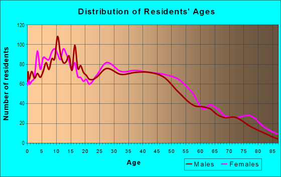
| Males: | 2,437 |
| Females: | 2,939 |
Males:
| This neighborhood: | 37.3 years |
| Whole city: | 35.4 years |
| This neighborhood: | 40.9 years |
| Whole city: | 38.2 years |
Average household size:
| The Corridor: | 2.3 people |
| Toledo: | 2.1 people |
Percentage of family households:
| The Corridor: | 31.9% |
| Toledo: | 37.8% |
| Here: | 23.2% |
| Toledo: | 29.6% |
Percentage of married-couple families with children (among all households):
| The Corridor: | 36.8% |
| Toledo: | 19.6% |
Percentage of single-mother households (among all households):
| The Corridor: | 25.2% |
| Toledo: | 21.5% |
Percentage of never married males 15 years old and over:
Percentage of never married females 15 years old and over:
| The Corridor: | 21.7% |
| Toledo: | 22.1% |
Percentage of never married females 15 years old and over:
| The Corridor: | 26.3% |
| city: | 21.2% |
Percentage of people that speak English not well or not at all:
| The Corridor: | 0.2% |
| Toledo: | 0.7% |
Percentage of people born in this state:
Percentage of people born in another U.S. state:
Percentage of native residents but born outside the U.S.:
Percentage of foreign born residents:
| Here: | 80.7% |
| Toledo: | 76.6% |
Percentage of people born in another U.S. state:
| The Corridor: | 16.9% |
| Toledo: | 19.3% |
Percentage of native residents but born outside the U.S.:
| Here: | 0.3% |
| city: | 0.6% |
Percentage of foreign born residents:
| Here: | 2.4% |
| Toledo: | 3.6% |

Owner-occupied
Renter-occupied


- Rooms in owner-occupied houses and condos in The Corridor
- 01 room
- 02 rooms
- 1233 rooms
- 2384 rooms
- 1095 rooms
- 1626 rooms
- 2897 rooms
- 1838 rooms
- 3309+ rooms

- Rooms in renter-occupied apartments in The Corridor
- 1151 room
- 3062 rooms
- 1703 rooms
- 8084 rooms
- 2975 rooms
- 4956 rooms
- 3537 rooms
- 1568 rooms
- 429+ rooms
Owner-occupied
Renter-occupied

- Bedrooms in owner-occupied houses and condos in The Corridor
- 19no bedroom
- 2141 bedroom
- 2982 bedrooms
- 4473 bedrooms
- 1934 bedrooms
- 4225+ bedrooms

- Bedrooms in renter-occupied apartments in The Corridor
- 123no bedroom
- 9081 bedroom
- 4172 bedrooms
- 3133 bedrooms
- 2384 bedrooms
- 105+ bedrooms
Average number of cars or other vehicles available in houses/condos:
Average number of cars or other vehicles available in apartments:
| This neighborhood: | |
| Toledo: |
Average number of cars or other vehicles available in apartments:
| Here: | 0.8 |
| city: | 1.2 |
Percentage of units with a mortgage:
| The Corridor: | 49.3% |
| Toledo: | 54.5% |

- Year house built in The Corridor
- 02020 or later
- 582010 to 2019
- 672000 to 2009
- 1681990 to 1999
- 2851980 to 1989
- 2511970 to 1979
- 3481960 to 1969
- 2631950 to 1959
- 2711940 to 1949
- 1,8521939 or earlier

City-data.com crime index for city in 2020 (higher means more crime):
| City: | 452.0 |
| U.S. average: | 219.5 |
Travel time to work (commute)
![Travel time to work (commute)]()
- 45Less than 5 minutes
- 1935 to 9 minutes
- 69810 to 14 minutes
- 34315 to 19 minutes
- 43520 to 24 minutes
- 6925 to 29 minutes
- 15030 to 34 minutes
- 2135 to 39 minutes
- 11540 to 44 minutes
- 39445 to 59 minutes
- 13860 to 89 minutes
- 3590 or more minutes

Means of transportation to work
![Means of transportation to work]()
- 74.5%1,462Drove a car alone
- 27.2%534Carpooled
- 7.1%139Bus
- 3.4%66Taxi
- 8.6%169Walked
- 7.9%155Other means
- 11.1%217Worked at home

Time leaving home to go to work
![Time leaving home to go to work]()
- 35912:00 a.m. to 4:59 a.m.
- 605:00 a.m. to 5:29 a.m.
- 625:30 a.m. to 5:59 a.m.
- 616:00 a.m. to 6:29 a.m.
- 806:30 a.m. to 6:59 a.m.
- 837:00 a.m. to 7:29 a.m.
- 2057:30 a.m. to 7:59 a.m.
- 3968:00 a.m. to 8:29 a.m.
- 668:30 a.m. to 8:59 a.m.
- 1429:00 a.m. to 9:59 a.m.
- 13110:00 a.m. to 10:59 a.m.
- 4411:00 a.m. to 11:59 a.m.
- 22512:00 p.m. to 3:59 p.m.
- 4394:00 p.m. to 11:59 p.m.

Occupations of males:
- Percentage of males in management occupations (except farmers):
Here: 10.4% city: 6.4%
- Percentage of males in architecture and engineering occupations:
Here: 5.2% city: 2.2%
- Percentage of males in arts, design, entertainment, sports, and media occupations:
Here: 1.3% city: 1.6%
- Percentage of males in service occupations:
Here: 16.7% city: 16.4%
- Percentage of males in sales and office occupations:
Here: 14.9% city: 14.8%
- Percentage of males in farming, fishing, and forestry occupations:
Here: 1.7% city: 0.2%
- Percentage of males in construction, extraction, and maintenance occupations:
Here: 6.2% city: 7.8%
- Percentage of males in production occupations:
Here: 5.5% city: 14.7%
- Percentage of males in transportation occupations:
Here: 12.5% city: 7.7%
- Percentage of males in material moving occupations:
Here: 20.7% city: 10.7%
Occupations of females:
- Percentage of females in management occupations (except farmers):
Here: 13.1% city: 7.4%
- Percentage of females in life, physical, and social science occupations:
Here: 6.0% city: 0.6%
- Percentage of females in community and social services occupations:
Here: 1.9% city: 2.8%
- Percentage of females in education, training, and library occupations:
Here: 1.7% city: 7.0%
- Percentage of females in healthcare practitioners and technical occupations:
Here: 3.7% city: 9.7%
- Percentage of females in service occupations:
Here: 30.0% city: 24.8%
- Percentage of females in sales and office occupations:
Here: 23.2% city: 27.5%
- Percentage of females in construction, extraction, and maintenance occupations:
Here: 1.3% city: 0.4%
- Percentage of females in production occupations:
Here: 8.8% city: 7.0%
- Percentage of females in material moving occupations:
Here: 6.6% city: 3.9%
Percentage of people 16-64 in Armed Forces:
| The Corridor: | 0.1% |
| Toledo: | 0.2% |
Education in this neighborhood (subdivision or community):
- Percentage of people 3 years and older in K-12 schools:
The Corridor: 43.1% Toledo: 16.7%
- Percentage of people 3 years and older in undergraduate colleges:
The Corridor: 4.2% Toledo: 6.1%
- Percentage of people 3 years and older in grad. or professional schools:
The Corridor: 5.5% Toledo: 1.7%
- Percentage of students K-12 enrolled in private schools:
The Corridor: 67.4% Toledo: 21.4%
Percentage of population below poverty level:
| The Corridor: | 26.5% |
| Toledo: | 23.3% |
Percentage of married-couple families with both working:
| The Corridor: | 123.2% |
| Toledo: | 69.3% |

- 57.7%Utility gas
- 27.9%Electricity
- 7.7%Other fuel
- 3.3%Bottled, tank, or LP gas
- 3.3%No fuel used
Limited-access highways (interstate or state) in this neighborhood:
I- 75
Length: 3.12 miles
Directions: E-W, N-S, SW-NE
Directions: E-W, N-S, SW-NE
Highways in this neighborhood:
W Central Ave (State Rte 120, Central Ave W)
Length: 1.61 miles
Direction: E-W
Address range: 221 to 1239
Direction: E-W
Address range: 221 to 1239
N Detroit Ave (US Hwy 24)
Length: 0.77 miles
Direction: SW-NE
Address range: 3100 to 3699
Direction: SW-NE
Address range: 3100 to 3699
Roads and streets:
Collingwood Blvd
Length: 1.85 miles
Direction: N-S
Address range: 2000 to 3499
Direction: N-S
Address range: 2000 to 3499
Parkwood Ave
Length: 1.68 miles
Directions: E-W, N-S, SE-NW
Address range: 2000 to 3399
Directions: E-W, N-S, SE-NW
Address range: 2000 to 3399
Scottwood Ave
Length: 1.39 miles
Directions: E-W, N-S, SE-NW
Address range: 1900 to 3199
Directions: E-W, N-S, SE-NW
Address range: 1900 to 3199
Cherry St
Length: 1.28 miles
Directions: E-W, N-S, SE-NW
Address range: 2544 to 3499
Directions: E-W, N-S, SE-NW
Address range: 2544 to 3499
Fulton St
Length: 1.15 miles
Direction: N-S
Address range: 2000 to 3099
Direction: N-S
Address range: 2000 to 3099
W Woodruff Ave
Length: 0.94 miles
Direction: E-W
Address range: 1 to 699
Direction: E-W
Address range: 1 to 699
Winthrop St
Length: 0.94 miles
Direction: E-W
Address range: 1 to 699
Direction: E-W
Address range: 1 to 699
W Bancroft St
Length: 0.94 miles
Direction: E-W
Address range: 1 to 648
Direction: E-W
Address range: 1 to 648
W Delaware Ave
Length: 0.94 miles
Direction: E-W
Address range: 1 to 635
Direction: E-W
Address range: 1 to 635
Islington St
Length: 0.89 miles
Directions: E-W, SW-NE
Address range: 100 to 634
Directions: E-W, SW-NE
Address range: 100 to 634
Franklin Ave
Length: 0.84 miles
Directions: N-S, SW-NE
Address range: 2000 to 2649
Directions: N-S, SW-NE
Address range: 2000 to 2649
Floyd St
Length: 0.84 miles
Direction: E-W
Address range: 100 to 699
Direction: E-W
Address range: 100 to 699
N Cove Blvd
Length: 0.83 miles
Directions: E-W, SW-NE
Address range: 800 to 1199
Directions: E-W, SW-NE
Address range: 800 to 1199
Arcadia Ave
Length: 0.81 miles
Directions: E-W, SE-NW, SW-NE
Address range: 325 to 799
Directions: E-W, SE-NW, SW-NE
Address range: 325 to 799
Putnam St
Length: 0.80 miles
Directions: N-S, SW-NE
Address range: 1900 to 2499
Directions: N-S, SW-NE
Address range: 1900 to 2499
Warren St
Length: 0.80 miles
Direction: N-S
Address range: 1956 to 2499
Direction: N-S
Address range: 1956 to 2499
Ashland Ave
Length: 0.75 miles
Direction: SE-NW
Address range: 1900 to 2399
Direction: SE-NW
Address range: 1900 to 2399
Glenwood Ave
Length: 0.67 miles
Directions: N-S, SW-NE
Address range: 3100 to 3499
Directions: N-S, SW-NE
Address range: 3100 to 3499
Melrose Ave
Length: 0.67 miles
Directions: E-W, SE-NW
Address range: 1 to 499
Directions: E-W, SE-NW
Address range: 1 to 499
Prescott St
Length: 0.66 miles
Direction: E-W
Address range: 1 to 499
Direction: E-W
Address range: 1 to 499
Machen St
Length: 0.66 miles
Direction: E-W
Address range: 1 to 499
Direction: E-W
Address range: 1 to 499
Maplewood Ave
Length: 0.59 miles
Directions: E-W, N-S, SW-NE
Address range: 3100 to 3499
Directions: E-W, N-S, SW-NE
Address range: 3100 to 3499
Batavia St
Length: 0.56 miles
Directions: E-W, SW-NE
Address range: 1 to 499
Directions: E-W, SW-NE
Address range: 1 to 499
Rockingham St
Length: 0.56 miles
Directions: E-W, SW-NE
Address range: 100 to 499
Directions: E-W, SW-NE
Address range: 100 to 499
Kenilworth Ave
Length: 0.51 miles
Directions: E-W, SW-NE
Address range: 200 to 499
Directions: E-W, SW-NE
Address range: 200 to 499
Highland Ave
Length: 0.51 miles
Directions: E-W, SW-NE
Address range: 500 to 799
Directions: E-W, SW-NE
Address range: 500 to 799
Columbia St
Length: 0.51 miles
Direction: E-W
Address range: 100 to 399
Direction: E-W
Address range: 100 to 399
Irving St
Length: 0.50 miles
Direction: E-W
Address range: 1 to 499
Direction: E-W
Address range: 1 to 499
Berdan Ave
Length: 0.43 miles
Directions: E-W, SE-NW
Address range: 700 to 849
Directions: E-W, SE-NW
Address range: 700 to 849
Boston Pl
Length: 0.33 miles
Direction: E-W
Address range: 300 to 499
Direction: E-W
Address range: 300 to 499
Victoria Pl
Length: 0.33 miles
Direction: E-W
Address range: 300 to 499
Direction: E-W
Address range: 300 to 499
N Cove Blvd N
Length: 0.29 miles
Directions: N-S, SW-NE
Directions: N-S, SW-NE
Nesslewood Ave
Length: 0.28 miles
Direction: E-W
Address range: 500 to 663
Direction: E-W
Address range: 500 to 663
Acklin Ave
Length: 0.28 miles
Direction: E-W
Address range: 500 to 699
Direction: E-W
Address range: 500 to 699
Virginia St
Length: 0.27 miles
Direction: E-W
Address range: 500 to 634
Direction: E-W
Address range: 500 to 634
Cambridge St
Length: 0.27 miles
Directions: E-W, N-S, SW-NE
Address range: 3100 to 3299
Directions: E-W, N-S, SW-NE
Address range: 3100 to 3299
Collins St
Length: 0.26 miles
Direction: E-W
Address range: 500 to 659
Direction: E-W
Address range: 500 to 659
Rosalind Pl
Length: 0.25 miles
Direction: SW-NE
Address range: 1 to 299
Direction: SW-NE
Address range: 1 to 299
Horton St
Length: 0.25 miles
Direction: N-S
Address range: 2000 to 2199
Direction: N-S
Address range: 2000 to 2199
Kimball Ave
Length: 0.24 miles
Direction: N-S
Address range: 3100 to 3299
Direction: N-S
Address range: 3100 to 3299
Brentwood Ave
Length: 0.20 miles
Direction: N-S
Address range: 2500 to 2799
Direction: N-S
Address range: 2500 to 2799
Castle Blvd
Length: 0.18 miles
Direction: E-W
Address range: 700 to 799
Direction: E-W
Address range: 700 to 799
Cumberland Pl
Length: 0.18 miles
Directions: E-W, SW-NE
Address range: 300 to 499
Directions: E-W, SW-NE
Address range: 300 to 499
Melington Dr
Length: 0.16 miles
Directions: E-W, N-S
Address range: 300 to 399
Directions: E-W, N-S
Address range: 300 to 399
Proctor Pl
Length: 0.14 miles
Directions: E-W, N-S, SE-NW, SW-NE
Address range: 1 to 58
Directions: E-W, N-S, SE-NW, SW-NE
Address range: 1 to 58
Kevin Pl
Length: 0.14 miles
Direction: SW-NE
Address range: 200 to 299
Direction: SW-NE
Address range: 200 to 299
Baldwin Pl
Length: 0.14 miles
Direction: E-W
Address range: 600 to 699
Direction: E-W
Address range: 600 to 699
Stratford Pl
Length: 0.14 miles
Direction: E-W
Address range: 600 to 699
Direction: E-W
Address range: 600 to 699
Tennyson Pl
Length: 0.13 miles
Direction: E-W
Address range: 500 to 699
Direction: E-W
Address range: 500 to 699
Winfield Rd
Length: 0.13 miles
Direction: E-W
Address range: 500 to 599
Direction: E-W
Address range: 500 to 599
Mellington Dr
Length: 0.13 miles
Directions: E-W, N-S
Address range: 412 to 499
Directions: E-W, N-S
Address range: 412 to 499
Rockwood Pl
Length: 0.12 miles
Direction: N-S
Address range: 2800 to 2999
Direction: N-S
Address range: 2800 to 2999
Willys Pkwy
Length: 0.12 miles
Direction: SE-NW
Direction: SE-NW
Adams St
Length: 0.12 miles
Direction: SE-NW
Address range: 2100 to 2199
Direction: SE-NW
Address range: 2100 to 2199
Lowell Dr
Length: 0.11 miles
Direction: E-W
Address range: 500 to 599
Direction: E-W
Address range: 500 to 599
Hackett Rd
Length: 0.11 miles
Direction: E-W
Address range: 500 to 599
Direction: E-W
Address range: 500 to 599
Bates Rd
Length: 0.11 miles
Direction: E-W
Address range: 500 to 599
Direction: E-W
Address range: 500 to 599
Acacia Aly
Length: 0.11 miles
Direction: E-W
Address range: 100 to 199
Direction: E-W
Address range: 100 to 199
Cadillac Ct
Length: 0.10 miles
Direction: E-W
Address range: 500 to 699
Direction: E-W
Address range: 500 to 699
Edmund Ln
Length: 0.10 miles
Directions: N-S, SE-NW
Address range: 2500 to 2599
Directions: N-S, SE-NW
Address range: 2500 to 2599
Albion St
Length: 0.09 miles
Directions: SE-NW, SW-NE
Address range: 2974 to 3099
Directions: SE-NW, SW-NE
Address range: 2974 to 3099
Tremain Dr
Length: 0.08 miles
Direction: SW-NE
Address range: 1 to 99
Direction: SW-NE
Address range: 1 to 99
Madison Ave
Length: 0.07 miles
Direction: SE-NW
Address range: 2300 to 2399
Direction: SE-NW
Address range: 2300 to 2399
N Cove Blvd S
Length: 0.07 miles
Direction: E-W
Direction: E-W
Chatham Ct
Length: 0.07 miles
Direction: E-W
Address range: 600 to 699
Direction: E-W
Address range: 600 to 699
Evanston Ct
Length: 0.06 miles
Directions: E-W, SE-NW
Address range: 3300 to 3399
Directions: E-W, SE-NW
Address range: 3300 to 3399
Nottingham Ter
Length: 0.06 miles
Direction: E-W
Address range: 500 to 599
Direction: E-W
Address range: 500 to 599
W Manhattan Blvd
Length: 0.06 miles
Direction: E-W
Address range: 459 to 499
Direction: E-W
Address range: 459 to 499
Colonial Ct
Length: 0.06 miles
Direction: E-W
Address range: 500 to 599
Direction: E-W
Address range: 500 to 599
Mentor Dr
Length: 0.05 miles
Direction: SW-NE
Address range: 300 to 399
Direction: SW-NE
Address range: 300 to 399
Lenox St
Length: 0.05 miles
Direction: E-W
Address range: 300 to 399
Direction: E-W
Address range: 300 to 399
Bryant Ct
Length: 0.05 miles
Direction: E-W
Address range: 400 to 499
Direction: E-W
Address range: 400 to 499
Unity Walk
Length: 0.05 miles
Direction: N-S
Address range: 2200 to 2299
Direction: N-S
Address range: 2200 to 2299
Devon Pl
Length: 0.05 miles
Direction: E-W
Address range: 500 to 599
Direction: E-W
Address range: 500 to 599
Jefferson Ave
Length: 0.04 miles
Directions: E-W, SE-NW
Address range: 2491 to 2495
Directions: E-W, SE-NW
Address range: 2491 to 2495
Evergreen Ct
Length: 0.04 miles
Direction: E-W
Address range: 400 to 499
Direction: E-W
Address range: 400 to 499
Hyde Pl
Length: 0.04 miles
Direction: N-S
Address range: 1 to 99
Direction: N-S
Address range: 1 to 99
22nd St
Length: 0.04 miles
Direction: SW-NE
Address range: 323 to 399
Direction: SW-NE
Address range: 323 to 399
23rd St
Length: 0.04 miles
Directions: N-S, SW-NE
Address range: 300 to 399
Directions: N-S, SW-NE
Address range: 300 to 399
W Central Ave (State Rte 120)
Length: 0.03 miles
Direction: E-W
Direction: E-W
Avon St
Length: 0.03 miles
Direction: N-S
Address range: 2300 to 2399
Direction: N-S
Address range: 2300 to 2399
Burnett Pl
Length: 0.03 miles
Direction: N-S
Address range: 2900 to 2999
Direction: N-S
Address range: 2900 to 2999
Railroad features:
New York Central RR
Length: 0.90 miles
Direction: SW-NE
Direction: SW-NE
Other features:
Ottawa Riv
Length: 1.33 miles
Directions: E-W, N-S, SE-NW, SW-NE
Directions: E-W, N-S, SE-NW, SW-NE
Willys Crk
Length: 0.18 miles
Directions: E-W, SW-NE
Directions: E-W, SW-NE