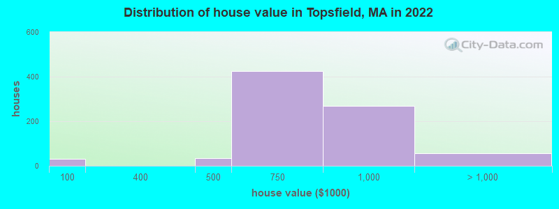
Estimated median house or condo value in 2022: $751,253 (it was $302,400 in 2000)
Topsfield:
$751,253
MA:
$534,700
Mean prices in 2022:all housing units: $645,471; detached houses: $712,185; townhouses or other attached units: $551,275; in 2-unit structures: $503,219; in 3-to-4-unit structures: $450,535; in 5-or-more-unit structures: $352,534; mobile homes: $123,118; occupied boats, rvs, vans, etc.: $131,058
Median gross rent in 2022: $1,012.
March 2022 cost of living index in Topsfield: 131.5 (high, U.S. average is 100)
The City-Data.com crime index weighs serious crimes and violent crimes more heavily. Higher means more crime, U.S. average is 246.1. It adjusts for the number of visitors and daily workers commuting into cities.
Ancestries: European (17.7%), Irish (15.3%), English (13.0%), Italian (10.7%), Polish (4.7%), American (2.7%).
Current Local Time: EST time zone
Incorporated in 1650
Elevation: 63 feet
Land area: 2.76 square miles.
Population density: 983 people per square mile (low).
220 residents are foreign born (3.5% Europe, 1.5% Latin America, 1.4% Asia, 1.3% Oceania).
This place:
7.9%
Massachusetts:
17.6%
Median real estate property taxes paid for housing units with mortgages in 2022: $9,573 (1.3%) Median real estate property taxes paid for housing units with no mortgage in 2022: $9,214 (1.2%)
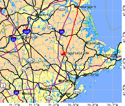
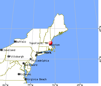
Nearest city with pop. 50,000+: Lynn, MA (11.4 miles , pop. 89,050).
Nearest city with pop. 200,000+: Boston, MA (23.0 miles , pop. 589,141).
Nearest city with pop. 1,000,000+: Bronx, NY (195.0 miles , pop. 1,332,650).
Air Quality Index (AQI) level in 2022 was 74.3. This is about average.
City:
74.3
U.S.:
72.6
Carbon Monoxide (CO) [ppm] level in 2022 was 0.267. This is about average.Closest monitor was 13.6 miles away from the city center.
City:
0.267
U.S.:
0.251
Nitrogen Dioxide (NO2) [ppb] level in 2022 was 8.64. This is significantly worse than average.Closest monitor was 2.7 miles away from the city center.
City:
8.64
U.S.:
5.11
Sulfur Dioxide (SO2) [ppb] level in 2022 was 0.358. This is significantly better than average.Closest monitor was 5.7 miles away from the city center.
City:
0.358
U.S.:
1.515
Ozone [ppb] level in 2022 was 27.4. This is better than average.Closest monitor was 3.4 miles away from the city center.
City:
27.4
U.S.:
33.3
Particulate Matter (PM2.5) [µg/m3] level in 2022 was 6.56. This is better than average.Closest monitor was 11.4 miles away from the city center.
City:
6.56
U.S.:
8.11
Tornado activity:
Topsfield-area historical tornado activity is slightly below Massachusetts state average. It is 47% smaller than the overall U.S. average.
On 9/29/1974, a category F3 (max. wind speeds 158-206 mph) tornado 12.5 miles away from the Topsfield place center injured one personand causedbetween $50,000 and $500,000 in damages.
On 6/9/1953, a category F4 (max. wind speeds 207-260 mph) tornado 37.2 miles away from the place center killed 90 peopleand injured 1228 peopleand causedbetween $50,000,000 and $500,000,000 in damages.
Earthquake activity:
Topsfield-area historical earthquake activity is significantly above Massachusetts state average. It is 73% smaller than the overall U.S. average.
On 4/20/2002 at 10:50:47, a magnitude 5.3 (5.3 ML, Depth: 3.0 mi, Class: Moderate, Intensity: VI - VII) earthquake occurred 188.8 miles away from the city center On 1/19/1982 at 00:14:42, a magnitude 4.7 (4.5 MB, 4.7 MD, 4.5 LG, Class: Light, Intensity: IV - V) earthquake occurred 67.9 miles away from the city center On 10/7/1983 at 10:18:46, a magnitude 5.3 (5.1 MB, 5.3 LG, 5.1 ML) earthquake occurred 193.2 miles away from the city center On 10/16/2012 at 23:12:25, a magnitude 4.7 (4.7 ML, Depth: 10.0 mi) earthquake occurred 68.0 miles away from the city center On 4/20/2002 at 10:50:47, a magnitude 5.2 (5.2 MB, 4.2 MS, 5.2 MW, 5.0 MW) earthquake occurred 188.4 miles away from Topsfield center On 8/22/1992 at 12:20:32, a magnitude 4.8 (4.8 MB, 3.8 MS, 4.7 LG, Depth: 6.2 mi) earthquake occurred 246.6 miles away from Topsfield center Magnitude types: regional Lg-wave magnitude (LG), body-wave magnitude (MB), duration magnitude (MD), local magnitude (ML), surface-wave magnitude (MS), moment magnitude (MW)
Natural disasters:
The number of natural disasters in Essex County (33) is a lot greater than the US average (15). Major Disasters (Presidential) Declared: 20 Emergencies Declared: 13
Causes of natural disasters: Floods: 14, Storms: 11, Hurricanes: 6, Snowstorms: 5, Winter Storms: 5, Snows: 3, Blizzards: 2, Fire: 1, Heavy Rain: 1, Snowfall: 1, Water Main Break: 1, Wind: 1 (Note: some incidents may be assigned to more than one category).
Hospitals and medical centers in Topsfield:
MASCONOMET HEALTHCARE CENTER (123 HIGH STREET)
Other hospitals and medical centers near Topsfield:
CHARLES V HOGAN REGIONAL CENTER (Hospital, about 4 miles away; HATHORNE, MA)
CEDAR GLEN CARE AND REHABILITATION CENTER (Nursing Home, about 5 miles away; DANVERS, MA)
CEDAR GLEN NURSING HOME (Nursing Home, about 5 miles away; DANVERS, MA)
HUNT NURS AND RET HOME INC (Nursing Home, about 5 miles away; DANVERS, MA)
HUNT NURSING AND REHAB CENTER (Nursing Home, about 5 miles away; DANVERS, MA)
HUNT HOSPITAL,THE (Hospital, about 5 miles away; DANVERS, MA)
NORTH SHORE REHABILITATION AND SNC (Nursing Home, about 5 miles away; DANVERS, MA)
TOPSFIELD TOWN LIBRARY (Operating income: $571,798; Location: 1 SOUTH COMMON STREET; 54,976 books; 5,315 audio materials; 3,333 video materials; 9 local licensed databases; 34 state licensed databases; 3 other licensed databases; 144 print serial subscriptions)
Birthplace of: Ryan Bourque - Ice hockey player, Asahel Huntington - Politician.
Essex County has a predicted average indoor radon screening level greater than 4 pCi/L (pico curies per liter) - Highest Potential
Drinking water stations with addresses in Topsfield and their reported violations in the past:
TOPSFIELD WATER DEPARTMENT (Population served: 5,305, Groundwater):
Past health violations:
MCL, Monthly (TCR) - In AUG-2008, Contaminant: Coliform. Follow-up actions: St AO (w/o penalty) issued (OCT-01-2008)
MCL, Monthly (TCR) - In OCT-2006, Contaminant: Coliform. Follow-up actions: St AO (w/o penalty) issued (DEC-12-2006)
Past monitoring violations:
Follow-up Or Routine LCR Tap M/R - In JAN-01-2007, Contaminant: Lead and Copper Rule. Follow-up actions: St AO (w/o penalty) issued (OCT-31-2007), St Compliance achieved (NOV-06-2007)
3 regular monitoring violations
EAGLE TOR TRUST (Address: 46 WENHAM ST , Population served: 38, Groundwater):
Past health violations:
MCL, Monthly (TCR) - In AUG-2009, Contaminant: Coliform. Follow-up actions: St AO (w/penalty) issued (JAN-28-2010)
Past monitoring violations:
Follow-up Or Routine LCR Tap M/R - In JAN-01-2007, Contaminant: Lead and Copper Rule. Follow-up actions: St AO (w/o penalty) issued (OCT-31-2007), St Compliance achieved (NOV-06-2007)
Follow-up Or Routine LCR Tap M/R - In OCT-01-2005, Contaminant: Lead and Copper Rule. Follow-up actions: St AO (w/penalty) issued (MAR-17-2006), St Compliance achieved (DEC-15-2006)
25 regular monitoring violations
Average household size:
This place:
2.7 people
Massachusetts:
2.5 people
Percentage of family households:
This place:
74.6%
Whole state:
63.0%
Percentage of households with unmarried partners:
This place:
2.9%
Whole state:
7.0%
Likely homosexual households (counted as self-reported same-sex unmarried-partner households)
Lesbian couples: 0.1% of all households
Gay men: 0.1% of all households
116 people in nursing facilities/skilled-nursing facilities in 2010
84 people in nursing homes in 2000
4 people in religious group quarters in 2000
Banks with branches in Topsfield (2011 data):
People's United Bank: Topsfield Branch at 15 Main Street, branch established on 1990/03/05. Info updated 2012/02/16: Bank assets: $27,319.3 mil, Deposits: $20,835.4 mil, headquarters in Bridgeport, CT, positive income, Commercial Lending Specialization, 374 total offices
TD Bank, National Association: Topsfield Branch at 16 Main Street, branch established on 1955/08/04. Info updated 2010/10/04: Bank assets: $188,912.6 mil, Deposits: $153,149.8 mil, headquarters in Wilmington, DE, positive income, 1314 total offices, Holding Company: Toronto-Dominion Bank, The
Sovereign Bank, National Association: Topsfield Branch at 20 Main Street, branch established on 1959/08/17. Info updated 2012/01/31: Bank assets: $78,146.9 mil, Deposits: $48,042.9 mil, headquarters in Wilmington, DE, positive income, Commercial Lending Specialization, 718 total offices, Holding Company: Banco Santander, S.A.
Religion statistics for Topsfield, MA (based on Essex County data)
Religion
Adherents
Congregations
Catholic
341,970
55
Mainline Protestant
33,710
140
Evangelical Protestant
20,925
160
Other
15,882
63
Orthodox
11,590
13
Black Protestant
376
3
None
318,706
-
Source: Clifford Grammich, Kirk Hadaway, Richard Houseal, Dale E.Jones, Alexei Krindatch, Richie Stanley and Richard H.Taylor. 2012. 2010 U.S.Religion Census: Religious Congregations & Membership Study. Association of Statisticians of American Religious Bodies. Jones, Dale E., et al. 2002. Congregations and Membership in the United States 2000. Nashville, TN: Glenmary Research Center. Graphs represent county-level data
FAA Registered Aircraft Manufacturers and Dealers:
3
PAN JET LLC, 461 Boston St Ste C4, Topsfield, MA 01983 Certificate: 05-0345 (LLC), Certificate Issue Date: 02/11/2005, Expiration Date: 02/10/2006
WARNER AEROCRAFT CORP, Po Box 114, Topsfield, MA 01983 Certificate: D002071 (Corporation), Certificate Issue Date: 03/17/2009, Expiration Date: 03/16/2010
PAN JET LLC, 461 Boston St Ste C4, Topsfield, MA 01983 Certificate: 05-0345 (Corporation), Certificate Issue Date: 02/11/2005, Expiration Date: 02/10/2006
FAA Registered Aircraft:
4
Aircraft: BOWMAN RAYMOND AND PENELOPE ROTORWAY EXEC (Category: Land, Seats: 2, Weight: Up to 12,499 Pounds), Engine: ROTORWAY RW152 (150 HP) (Reciprocating) N-Number: 19PR, N19PR, N-19PR, Serial Number: 3547, Year manufactured: 1991, Airworthiness Date: 07/10/1991, Certificate Issue Date: 05/25/1988 Registrant (Co-Owned): Raymond C Bowman, Po Box 420, Topsfield, MA 01983, Other Owners: Penelope A Bowman
Aircraft: MORRIS CHARLES LEE STEPCHILD 22 (Category: Land, Seats: 2, Weight: Up to 12,499 Pounds), Engine: LYCOMING 0-290 SERIES (140 HP) (Reciprocating) N-Number: 224M, N224M, N-224M, Serial Number: 1, Year manufactured: 1991, Airworthiness Date: 12/21/1998, Certificate Issue Date: 08/28/1995 Registrant (Individual): Robert N Edwards, 68 Parsonage Ln, Topsfield, MA 01983
Aircraft: CESSNA 182P (Category: Land, Seats: 4, Weight: Up to 12,499 Pounds, Speed: 120 mph), Engine: CONT MOTOR O-470 SERIES (230 HP) (Reciprocating) N-Number: 4703K, N4703K, N-4703K, Serial Number: 18263702, Year manufactured: 1975, Airworthiness Date: 03/18/1975, Certificate Issue Date: 03/24/2020 Registrant (Individual): Robert C Skeffington, 82 North St, Topsfield, MA 01983
Aircraft: PIPER PA-28-140 (Category: Land, Seats: 4, Weight: Up to 12,499 Pounds, Speed: 107 mph), Engine: LYCOMING 0-320 SERIES (180 HP) (Reciprocating) N-Number: 901TQ, N901TQ, N-901TQ, Serial Number: 28-7725178, Year manufactured: 1977, Airworthiness Date: 02/24/1977, Certificate Issue Date: 09/04/2013 Registrant (Individual): Lance S Eskelund, 20 Willowdale Rd, Topsfield, MA 01983
Home Mortgage Disclosure Act Aggregated Statistics For Year 2009 (Based on 1 partial tract)
A) FHA, FSA/RHS & VA Home Purchase Loans
B) Conventional Home Purchase Loans
C) Refinancings
D) Home Improvement Loans
F) Non-occupant Loans on < 5 Family Dwellings (A B C & D)
Number
Average Value
Number
Average Value
Number
Average Value
Number
Average Value
Number
Average Value
LOANS ORIGINATED
2
$430,995
10
$330,105
63
$313,689
3
$230,160
1
$199,280
APPLICATIONS APPROVED, NOT ACCEPTED
0
$0
0
$0
4
$299,610
1
$59,780
0
$0
APPLICATIONS DENIED
0
$0
1
$364,640
9
$390,810
1
$148,400
1
$567,310
APPLICATIONS WITHDRAWN
0
$0
2
$393,790
6
$341,885
1
$367,180
1
$631,970
FILES CLOSED FOR INCOMPLETENESS
0
$0
0
$0
2
$327,540
0
$0
0
$0
Aggregated Statistics For Year 2008 (Based on 1 partial tract)
A) FHA, FSA/RHS & VA Home Purchase Loans
B) Conventional Home Purchase Loans
C) Refinancings
D) Home Improvement Loans
F) Non-occupant Loans on < 5 Family Dwellings (A B C & D)
Number
Average Value
Number
Average Value
Number
Average Value
Number
Average Value
Number
Average Value
LOANS ORIGINATED
1
$305,280
10
$375,622
23
$338,287
2
$144,370
2
$284,505
APPLICATIONS APPROVED, NOT ACCEPTED
0
$0
1
$396,440
1
$433,330
1
$93,280
0
$0
APPLICATIONS DENIED
0
$0
1
$871,530
3
$401,033
0
$0
0
$0
APPLICATIONS WITHDRAWN
0
$0
1
$394,110
3
$379,267
0
$0
0
$0
FILES CLOSED FOR INCOMPLETENESS
0
$0
0
$0
1
$296,800
0
$0
0
$0
Aggregated Statistics For Year 2007 (Based on 1 partial tract)
B) Conventional Home Purchase Loans
C) Refinancings
D) Home Improvement Loans
F) Non-occupant Loans on < 5 Family Dwellings (A B C & D)
Number
Average Value
Number
Average Value
Number
Average Value
Number
Average Value
LOANS ORIGINATED
12
$341,691
20
$344,012
6
$120,628
1
$265,000
APPLICATIONS APPROVED, NOT ACCEPTED
2
$277,190
4
$270,405
1
$54,060
0
$0
APPLICATIONS DENIED
2
$443,185
4
$409,478
1
$236,380
0
$0
APPLICATIONS WITHDRAWN
1
$342,800
2
$272,630
1
$341,320
0
$0
FILES CLOSED FOR INCOMPLETENESS
0
$0
1
$128,260
0
$0
0
$0
Aggregated Statistics For Year 2006 (Based on 1 partial tract)
B) Conventional Home Purchase Loans
C) Refinancings
D) Home Improvement Loans
F) Non-occupant Loans on < 5 Family Dwellings (A B C & D)
Number
Average Value
Number
Average Value
Number
Average Value
Number
Average Value
LOANS ORIGINATED
12
$309,113
29
$331,985
7
$117,297
1
$218,150
APPLICATIONS APPROVED, NOT ACCEPTED
1
$126,140
3
$304,713
1
$57,880
0
$0
APPLICATIONS DENIED
1
$425,700
10
$404,941
3
$121,477
1
$93,280
APPLICATIONS WITHDRAWN
1
$336,870
9
$275,977
1
$27,770
0
$0
FILES CLOSED FOR INCOMPLETENESS
0
$0
2
$502,120
0
$0
0
$0
Aggregated Statistics For Year 2005 (Based on 1 partial tract)
B) Conventional Home Purchase Loans
C) Refinancings
D) Home Improvement Loans
F) Non-occupant Loans on < 5 Family Dwellings (A B C & D)
Number
Average Value
Number
Average Value
Number
Average Value
Number
Average Value
LOANS ORIGINATED
21
$330,235
31
$324,210
6
$141,898
1
$243,800
APPLICATIONS APPROVED, NOT ACCEPTED
2
$372,270
5
$253,594
1
$39,220
0
$0
APPLICATIONS DENIED
2
$281,750
7
$444,049
1
$91,800
0
$0
APPLICATIONS WITHDRAWN
2
$380,540
9
$356,843
1
$313,550
1
$216,240
FILES CLOSED FOR INCOMPLETENESS
0
$0
3
$308,320
0
$0
0
$0
Aggregated Statistics For Year 2004 (Based on 1 partial tract)
B) Conventional Home Purchase Loans
C) Refinancings
D) Home Improvement Loans
F) Non-occupant Loans on < 5 Family Dwellings (A B C & D)
Number
Average Value
Number
Average Value
Number
Average Value
Number
Average Value
LOANS ORIGINATED
18
$431,255
42
$292,721
4
$165,838
2
$237,650
APPLICATIONS APPROVED, NOT ACCEPTED
3
$409,020
3
$348,317
1
$55,540
0
$0
APPLICATIONS DENIED
2
$382,870
8
$353,378
2
$148,295
0
$0
APPLICATIONS WITHDRAWN
1
$506,470
7
$319,909
1
$114,480
0
$0
FILES CLOSED FOR INCOMPLETENESS
0
$0
6
$403,825
0
$0
0
$0
Aggregated Statistics For Year 2003 (Based on 1 partial tract)
B) Conventional Home Purchase Loans
C) Refinancings
D) Home Improvement Loans
F) Non-occupant Loans on < 5 Family Dwellings (A B C & D)
Number
Average Value
Number
Average Value
Number
Average Value
Number
Average Value
LOANS ORIGINATED
15
$368,640
138
$249,509
2
$152,640
1
$511,980
APPLICATIONS APPROVED, NOT ACCEPTED
2
$248,890
17
$246,207
1
$115,540
0
$0
APPLICATIONS DENIED
2
$379,055
13
$285,140
1
$56,180
0
$0
APPLICATIONS WITHDRAWN
1
$360,610
13
$289,690
0
$0
0
$0
FILES CLOSED FOR INCOMPLETENESS
0
$0
1
$222,810
0
$0
0
$0
Aggregated Statistics For Year 2002 (Based on 1 partial tract)
B) Conventional Home Purchase Loans
C) Refinancings
D) Home Improvement Loans
F) Non-occupant Loans on < 5 Family Dwellings (A B C & D)
Number
Average Value
Number
Average Value
Number
Average Value
Number
Average Value
LOANS ORIGINATED
15
$290,228
96
$248,221
5
$75,048
1
$237,860
APPLICATIONS APPROVED, NOT ACCEPTED
0
$0
9
$209,150
1
$58,300
0
$0
APPLICATIONS DENIED
1
$139,920
9
$271,196
2
$65,510
0
$0
APPLICATIONS WITHDRAWN
2
$390,290
9
$265,047
0
$0
0
$0
FILES CLOSED FOR INCOMPLETENESS
0
$0
3
$333,333
0
$0
0
$0
Aggregated Statistics For Year 2001 (Based on 1 partial tract)
B) Conventional Home Purchase Loans
C) Refinancings
D) Home Improvement Loans
F) Non-occupant Loans on < 5 Family Dwellings (A B C & D)
Number
Average Value
Number
Average Value
Number
Average Value
Number
Average Value
LOANS ORIGINATED
17
$292,660
64
$231,580
1
$70,600
1
$245,500
APPLICATIONS APPROVED, NOT ACCEPTED
1
$318,420
5
$214,544
1
$102,180
0
$0
APPLICATIONS DENIED
2
$353,510
6
$236,203
2
$55,120
0
$0
APPLICATIONS WITHDRAWN
1
$317,790
7
$193,586
1
$130,380
0
$0
FILES CLOSED FOR INCOMPLETENESS
0
$0
2
$217,725
0
$0
0
$0
Aggregated Statistics For Year 2000 (Based on 1 partial tract)
B) Conventional Home Purchase Loans
C) Refinancings
D) Home Improvement Loans
F) Non-occupant Loans on < 5 Family Dwellings (A B C & D)
Number
Average Value
Number
Average Value
Number
Average Value
Number
Average Value
LOANS ORIGINATED
18
$267,473
11
$197,064
3
$35,333
1
$190,160
APPLICATIONS APPROVED, NOT ACCEPTED
3
$325,280
2
$150,095
2
$71,445
0
$0
APPLICATIONS DENIED
2
$371,740
4
$179,458
1
$156,670
0
$0
APPLICATIONS WITHDRAWN
1
$272,000
2
$177,020
0
$0
0
$0
FILES CLOSED FOR INCOMPLETENESS
0
$0
1
$157,090
0
$0
0
$0
Aggregated Statistics For Year 1999 (Based on 1 partial tract)
B) Conventional Home Purchase Loans
C) Refinancings
D) Home Improvement Loans
F) Non-occupant Loans on < 5 Family Dwellings (A B C & D)
Detailed PMIC statistics for the following Tracts:2141.00
2002 - 2018 National Fire Incident Reporting System (NFIRS) incidents
According to the data from the years 2002 - 2018 the average number of fires per year is 87. The highest number of reported fires - 118 took place in 2007, and the least - 53 in 2005. The data has a growing trend.
When looking into fire subcategories, the most incidents belonged to: Structure Fires (77.9%), and Outside Fires (16.7%).
Fire incident types reported to NFIRS in Topsfield, MA


 Recent articles from our blog. Our writers, many of them Ph.D. graduates or candidates, create easy-to-read articles on a wide variety of topics.

 (11.4 miles


 According to the data from the years 2002 - 2018 the average number of fires per year is 87. The highest number of reported fires - 118 took place in 2007, and the least - 53 in 2005. The data has a growing trend.
 When looking into fire subcategories, the most incidents belonged to: Structure Fires (77.9%), and Outside Fires (16.7%).