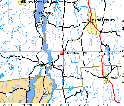
Shoreham, Vermont
Submit your own pictures of this town and show them to the world
- OSM Map
- General Map
- Google Map
- MSN Map
Population change since 2000: +3.5%
 |
| Males: 637 | |
| Females: 628 |
| Median resident age: | 44.7 years |
| Vermont median age: | 45.8 years |
Zip codes: 05770.
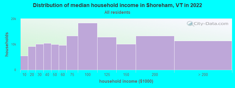
| Shoreham: | $78,348 |
| VT: | $73,991 |
Estimated per capita income in 2022: $38,707 (it was $17,650 in 2000)
Shoreham town income, earnings, and wages data
Estimated median house or condo value in 2022: $336,417 (it was $112,300 in 2000)
| Shoreham: | $336,417 |
| VT: | $304,700 |
Mean prices in 2022: all housing units: $400,302; detached houses: $427,258; townhouses or other attached units: $389,241; in 2-unit structures: $373,341; in 3-to-4-unit structures: $633,103; in 5-or-more-unit structures: $292,995; mobile homes: $101,709
Detailed information about poverty and poor residents in Shoreham, VT


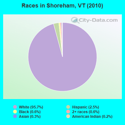
- 1,21195.7%White alone
- 312.5%Hispanic
- 80.6%Black alone
- 80.6%Two or more races
- 40.3%Asian alone
- 30.2%American Indian alone
Races in Shoreham detailed stats: ancestries, foreign born residents, place of birth
According to our research of Vermont and other state lists, there were 2 registered sex offenders living in Shoreham, Vermont as of June 08, 2024.
The ratio of all residents to sex offenders in Shoreham is 633 to 1.
The ratio of registered sex offenders to all residents in this city is lower than the state average.
 Recent articles from our blog. Our writers, many of them Ph.D. graduates or candidates, create easy-to-read articles on a wide variety of topics.

 | Cell Phone Coverage (69 replies) |
| Need Help Planning A 7 State New England Fall Foliage Tour (39 replies) |
| Vermont Weather (3779 replies) |
| WhistlePig Farms (49 replies) |
| Looking to move to NE Region... (5 replies) |
| What no Champlain bridge construction thread? (37 replies) |
Latest news from Shoreham, VT collected exclusively by city-data.com from local newspapers, TV, and radio stations
Ancestries: English (17.9%), French Canadian (16.6%), Irish (13.9%), French (11.6%), United States (10.3%), German (8.2%).
Current Local Time: EST time zone
Elevation: 333 feet
Land area: 43.5 square miles.
Population density: 29 people per square mile (very low).
30 residents are foreign born (1.3% Europe, 0.6% Asia, 0.6% North America).
| This town: | 2.5% |
| Vermont: | 3.8% |
| Shoreham town: | 2.0% ($2,282) |
| Vermont: | 2.0% ($2,196) |
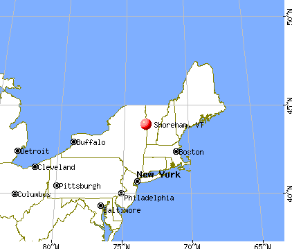
Nearest city with pop. 50,000+: Schenectady, NY  (81.4 miles , pop. 61,821).
Nearest city with pop. 200,000+: Boston, MA (156.2 miles , pop. 589,141).
Nearest city with pop. 1,000,000+: Bronx, NY (212.6 miles , pop. 1,332,650).
Nearest cities:
), ), Latitude: 43.89 N, Longitude: 73.31 W
Area code: 802

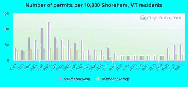
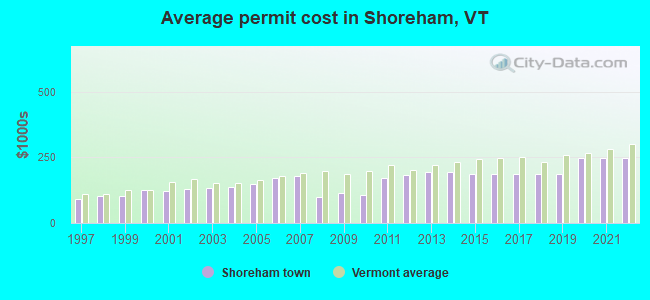
Single-family new house construction building permits:
- 2022: 6 buildings, average cost: $248,200
- 2021: 6 buildings, average cost: $248,200
- 2020: 5 buildings, average cost: $248,200
- 2019: 2 buildings, average cost: $187,500
- 2018: 2 buildings, average cost: $187,500
- 2017: 2 buildings, average cost: $187,500
- 2016: 2 buildings, average cost: $187,500
- 2015: 2 buildings, average cost: $187,500
- 2014: 2 buildings, average cost: $193,300
- 2013: 2 buildings, average cost: $193,300
- 2012: 3 buildings, average cost: $184,000
- 2011: 5 buildings, average cost: $172,800
- 2010: 4 buildings, average cost: $107,500
- 2009: 4 buildings, average cost: $112,500
- 2008: 4 buildings, average cost: $100,000
- 2007: 8 buildings, average cost: $181,200
- 2006: 7 buildings, average cost: $171,000
- 2005: 8 buildings, average cost: $150,200
- 2004: 8 buildings, average cost: $138,800
- 2003: 9 buildings, average cost: $132,600
- 2002: 15 buildings, average cost: $128,800
- 2001: 13 buildings, average cost: $121,400
- 2000: 8 buildings, average cost: $126,100
- 1999: 9 buildings, average cost: $102,500
- 1998: 4 buildings, average cost: $101,700
- 1997: 5 buildings, average cost: $91,700
| Here: | 1.5% |
| Vermont: | 2.0% |
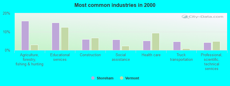
- Agriculture, forestry, fishing & hunting (15.8%)
- Educational services (14.9%)
- Construction (5.9%)
- Social assistance (5.8%)
- Health care (5.2%)
- Truck transportation (4.6%)
- Professional, scientific, technical services (4.1%)
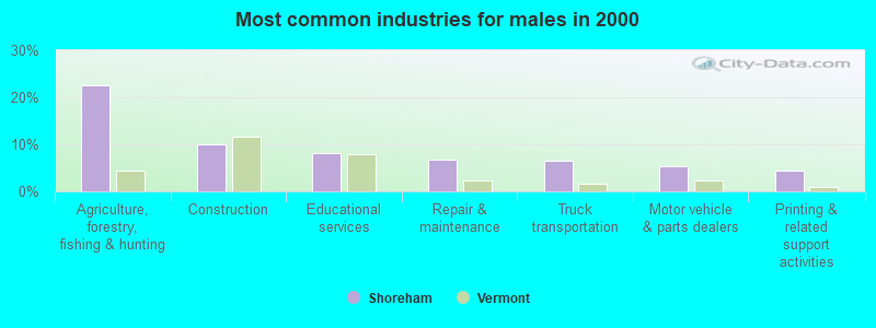
- Agriculture, forestry, fishing & hunting (22.6%)
- Construction (9.9%)
- Educational services (8.2%)
- Repair & maintenance (6.8%)
- Truck transportation (6.5%)
- Motor vehicle & parts dealers (5.4%)
- Printing & related support activities (4.5%)
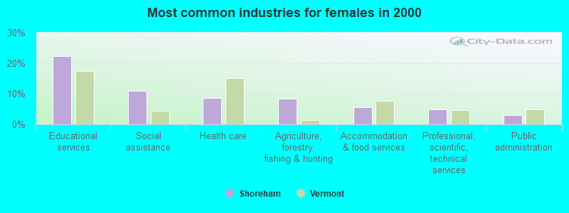
- Educational services (22.4%)
- Social assistance (10.9%)
- Health care (8.7%)
- Agriculture, forestry, fishing & hunting (8.4%)
- Accommodation & food services (5.6%)
- Professional, scientific, technical services (5.0%)
- Public administration (3.1%)
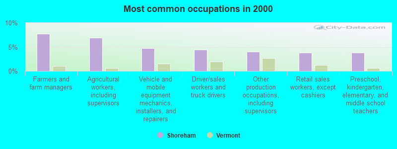
- Farmers and farm managers (7.7%)
- Agricultural workers, including supervisors (7.0%)
- Vehicle and mobile equipment mechanics, installers, and repairers (4.7%)
- Driver/sales workers and truck drivers (4.4%)
- Other production occupations, including supervisors (4.0%)
- Retail sales workers, except cashiers (3.8%)
- Preschool, kindergarten, elementary, and middle school teachers (3.8%)
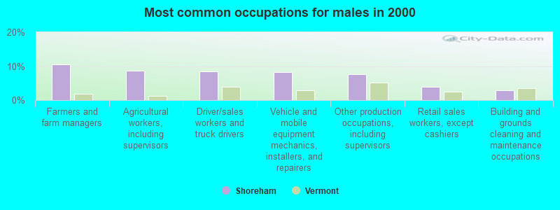
- Farmers and farm managers (10.5%)
- Agricultural workers, including supervisors (8.8%)
- Driver/sales workers and truck drivers (8.5%)
- Vehicle and mobile equipment mechanics, installers, and repairers (8.2%)
- Other production occupations, including supervisors (7.6%)
- Retail sales workers, except cashiers (4.0%)
- Building and grounds cleaning and maintenance occupations (2.8%)
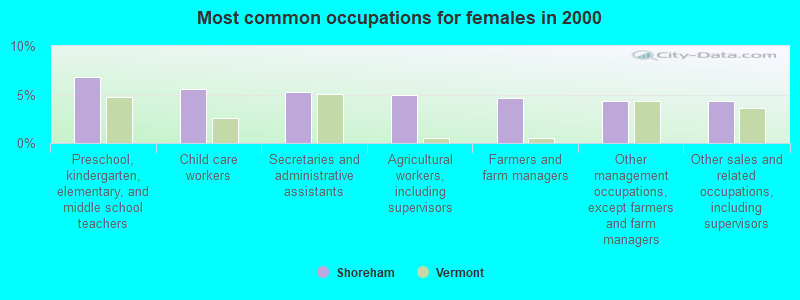
- Preschool, kindergarten, elementary, and middle school teachers (6.8%)
- Child care workers (5.6%)
- Secretaries and administrative assistants (5.3%)
- Agricultural workers, including supervisors (5.0%)
- Farmers and farm managers (4.7%)
- Other management occupations, except farmers and farm managers (4.3%)
- Other sales and related occupations, including supervisors (4.3%)
Average climate in Shoreham, Vermont
Based on data reported by over 4,000 weather stations


Earthquake activity:
Shoreham-area historical earthquake activity is significantly above Vermont state average. It is 70% smaller than the overall U.S. average.On 4/20/2002 at 10:50:47, a magnitude 5.3 (5.3 ML, Depth: 3.0 mi, Class: Moderate, Intensity: VI - VII) earthquake occurred 47.0 miles away from Shoreham center
On 10/7/1983 at 10:18:46, a magnitude 5.3 (5.1 MB, 5.3 LG, 5.1 ML) earthquake occurred 51.5 miles away from the city center
On 4/20/2002 at 10:50:47, a magnitude 5.2 (5.2 MB, 4.2 MS, 5.2 MW, 5.0 MW) earthquake occurred 45.8 miles away from Shoreham center
On 1/19/1982 at 00:14:42, a magnitude 4.7 (4.5 MB, 4.7 MD, 4.5 LG, Class: Light, Intensity: IV - V) earthquake occurred 89.8 miles away from the city center
On 10/16/2012 at 23:12:25, a magnitude 4.7 (4.7 ML, Depth: 10.0 mi) earthquake occurred 134.3 miles away from the city center
On 4/20/2000 at 08:46:55, a magnitude 3.8 (3.8 ML, Depth: 3.1 mi, Class: Light, Intensity: II - III) earthquake occurred 47.2 miles away from Shoreham center
Magnitude types: regional Lg-wave magnitude (LG), body-wave magnitude (MB), duration magnitude (MD), local magnitude (ML), surface-wave magnitude (MS), moment magnitude (MW)
Natural disasters:
The number of natural disasters in Addison County (23) is greater than the US average (15).Major Disasters (Presidential) Declared: 16
Emergencies Declared: 3
Causes of natural disasters: Floods: 16, Storms: 15, Drought: 1, Heavy Rain: 1, Hurricane: 1, Ice Storm: 1, Landslide: 1, Snow: 1, Snowstorm: 1, Tornado: 1, Tropical Storm: 1, Wind: 1, Winter Storm: 1, Other: 1 (Note: some incidents may be assigned to more than one category).

Hospitals and medical centers near Shoreham:
- MOSES-LUDINGTON HOSPITAL Critical Access Hospitals (about 7 miles away; TICONDEROGA, NY)
- HERITAGE COMMONS RESIDENTIAL HEALTH CARE (Nursing Home, about 7 miles away; TICONDEROGA, NY)
- HELEN PORTER HEALTHCARE AND REHAB (Nursing Home, about 11 miles away; MIDDLEBURY, VT)
- PORTER HOSPITAL, INC Critical Access Hospitals (about 11 miles away; MIDDLEBURY, VT)
Airports located in Shoreham:
- Brisson Airport (37VT) (Runways: 1)
Amtrak stations near Shoreham:
- 5 miles: TICONDEROGA (RTE. 74 (FORT TICONDEROGA RD.)) . Services: enclosed waiting area, public restrooms, free short-term parking, free long-term parking, call for taxi service.
- 13 miles: PORT HENRY (RTE. 9 NORTH & RTE. 22) . Services: enclosed waiting area, public restrooms, public payphones, free short-term parking, free long-term parking, call for car rental service, call for taxi service.
Colleges/universities with over 2000 students nearest to Shoreham:
- Middlebury College (about 11 miles; Middlebury, VT; Full-time enrollment: 3,077)
- Castleton State College (about 21 miles; Castleton, VT; FT enrollment: 2,079)
- Norwich University (about 37 miles; Northfield, VT; FT enrollment: 4,221)
- Champlain College (about 41 miles; Burlington, VT; FT enrollment: 2,623)
- Adirondack Community College (about 42 miles; Queensbury, NY; FT enrollment: 2,826)
- University of Vermont (about 42 miles; Burlington, VT; FT enrollment: 11,566)
- Community College of Vermont (about 42 miles; Winooski, VT; FT enrollment: 3,394)
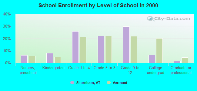
Public elementary/middle school in Shoreham:
- SHOREHAM ELEMENTARY SCHOOL (Students: 94, Location: 130 SCHOOL ROAD, Grades: PK-6)
Points of interest:
Notable locations in Shoreham: Larrabees Point Station (A), Platt Memorial Library (B), Larrabees Point Complex (C), Shoreham Fire Department (D). Display/hide their locations on the map
Churches in Shoreham include: Shoreham Congregational Church (A), Saint Genevieve Church (B), All Saint Chapel (C). Display/hide their locations on the map
Cemeteries: East Shoreham Cemetery (1), Lakeview Cemetery (2), Lapell Cemetery (3), Callender Cemetery (4), Jennison Cemetery (5), Knapp Cemetery (6), Rich Family Cemetery (7). Display/hide their locations on the map
Reservoirs and swamps: Richville Pond (A), Cedar Swamp (B). Display/hide their locations on the map
Streams, rivers, and creeks: Sawmill Brook (A), Perry Brook (B), Bascom Brook (C). Display/hide their locations on the map
Birthplace of: Ansel Briggs - Politician, Columbus Delano - Politician, Ebenezer J. Ormsbee - Politician, Levi P. Morton - Politician, Joel Turrill - Politician, John W. Cary - Politician, Silas H. Jennison - Politician.
| This town: | 2.5 people |
| Vermont: | 2.3 people |
| This town: | 70.6% |
| Whole state: | 62.5% |
| This town: | 10.4% |
| Whole state: | 9.2% |
Likely homosexual households (counted as self-reported same-sex unmarried-partner households)
- Lesbian couples: 1.0% of all households
- Gay men: 0.4% of all households
| This town: | 7.5% |
| Whole state: | 9.4% |
| This town: | 1.7% |
| Whole state: | 3.6% |
Banks with branches in Shoreham (2011 data):
- The First National Bank of Orwell: The First National Bank Of Orwell -s at 2936 Vt Route 22a, branch established on 2006/12/11. Info updated 2010/06/02: Bank assets: $41.6 mil, Deposits: $37.7 mil, headquarters in Orwell, VT, positive income, Mortgage Lending Specialization, 2 total offices
For population 15 years and over in Shoreham:
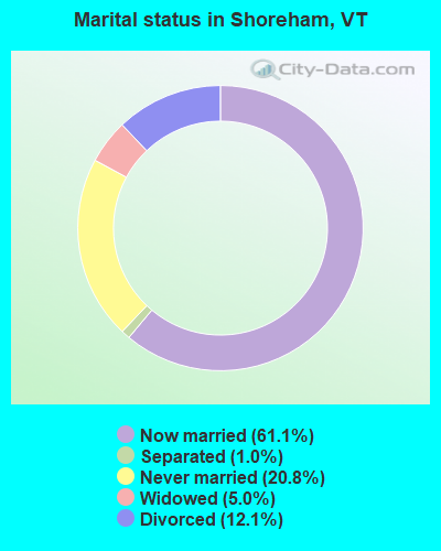
- Never married: 20.8%
- Now married: 61.1%
- Separated: 1.0%
- Widowed: 5.0%
- Divorced: 12.1%
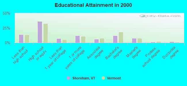
For population 25 years and over in Shoreham:
- High school or higher: 85.9%
- Bachelor's degree or higher: 23.4%
- Graduate or professional degree: 11.2%
- Unemployed: 2.3%
- Mean travel time to work (commute): 25.0 minutes
| Here: | 12.1 |
| Vermont average: | 11.7 |
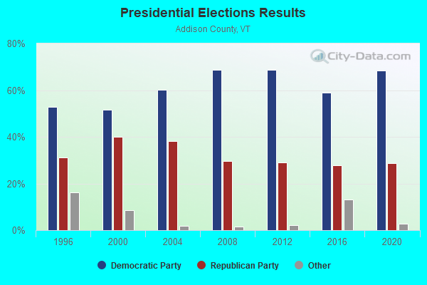
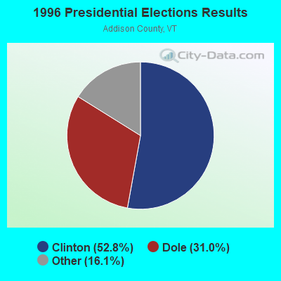

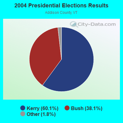
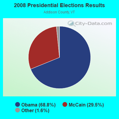
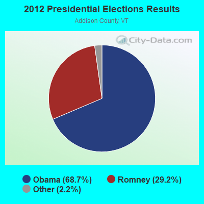

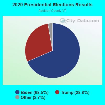
Graphs represent county-level data. Detailed 2008 Election Results
Religion statistics for Shoreham, VT (based on Addison County data)
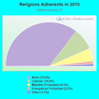
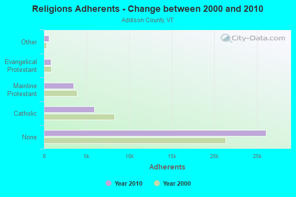
| Religion | Adherents | Congregations |
|---|---|---|
| Catholic | 5,892 | 6 |
| Mainline Protestant | 3,491 | 27 |
| Evangelical Protestant | 801 | 13 |
| Other | 560 | 6 |
| None | 26,077 | - |
Food Environment Statistics:
| Addison County: | 4.64 / 10,000 pop. |
| Vermont: | 3.84 / 10,000 pop. |
| Here: | 1.36 / 10,000 pop. |
| State: | 1.95 / 10,000 pop. |
| This county: | 6.55 / 10,000 pop. |
| Vermont: | 6.40 / 10,000 pop. |
| Here: | 8.45 / 10,000 pop. |
| State: | 11.52 / 10,000 pop. |
| This county: | 5.8% |
| Vermont: | 6.8% |
| Addison County: | 20.9% |
| State: | 22.3% |
| This county: | 9.1% |
| State: | 13.3% |
Strongest AM radio stations in Shoreham:
- WIPS (1250 AM; 1 kW; TICONDEROGA, NY; Owner: CALVIN HUGH CARR)
- WGY (810 AM; 50 kW; SCHENECTADY, NY; Owner: CLEAR CHANNEL BROADCASTING LICENSES, INC.)
- WCHP (760 AM; 35 kW; CHAMPLAIN, NY; Owner: CHAMPLAIN RADIO, INC.)
- WFAD (1490 AM; 1 kW; MIDDLEBURY, VT; Owner: ADDISON BROADCASTING COMPANY, INC.)
- WSYB (1380 AM; 5 kW; RUTLAND, VT; Owner: CAPSTAR TX LIMITED PARTNERSHIP)
- WICY (1490 AM; 50 kW; MALONE, NY; Owner: CARTIER COMMUNICATIONS INC.)
- WNNZ (640 AM; 50 kW; WESTFIELD, MA; Owner: CLEAR CHANNEL BROADCASTING LICENSES, INC.)
- WDEV (550 AM; 5 kW; WATERBURY, VT; Owner: RADIO VERMONT, INC.)
- WPTR (1540 AM; 50 kW; ALBANY, NY; Owner: KIMTRON, INC.)
- WVMT (620 AM; 5 kW; BURLINGTON, VT; Owner: SISON BROADCASTING, INC.)
- WRKO (680 AM; 50 kW; BOSTON, MA; Owner: ENTERCOM BOSTON LICENSE, LLC)
- WCRN (830 AM; 50 kW; WORCESTER, MA; Owner: CARTER BROADCASTING CORPORATION)
- WIRD (920 AM; 5 kW; LAKE PLACID, NY; Owner: RADIO LAKE PLACID INC)
Strongest FM radio stations in Shoreham:
- WEXP (101.5 FM; BRANDON, VT; Owner: VOX VERMONT, L.L.C.)
- WANC (103.9 FM; TICONDEROGA, NY; Owner: WAMC)
- WDEV-FM (96.1 FM; WARREN, VT; Owner: RADIO VERMONT, INC.)
- WEBK (105.3 FM; KILLINGTON, VT; Owner: 6 JOHNSON ROAD LICENSES, INC.)
- WWFY (100.9 FM; BERLIN, VT; Owner: VOX ALLEGANY, LLC)
- WJJR (98.1 FM; RUTLAND, VT; Owner: 6 JOHNSON ROAD LICENSES, INC.)
- WZRT (97.1 FM; RUTLAND, VT; Owner: CAPSTAR TX LIMITED PARTNERSHIP)
- WGLV (91.7 FM; WOODSTOCK, VT; Owner: CHRISTIAN MINISTRIES INC)
- WHDQ-FM1 (106.1 FM; RUTLAND, VT; Owner: GREAT NORTHERN RADIO, L.L.C.)
- WJEN (94.5 FM; RUTLAND, VT; Owner: 6 JOHNSON ROAD LICENSES, INC.)
- WCVT (101.7 FM; STOWE, VT; Owner: RADIO VERMONT CLASSICS, L.L.C.)
- WXLG (89.9 FM; NORTH CREEK, NY; Owner: THE ST. LAWRENCE UNIVERSITY)
- WVPS (107.9 FM; BURLINGTON, VT; Owner: VERMONT PUBLIC RADIO)
- WEZF (92.9 FM; BURLINGTON, VT; Owner: CAPSTAR TX LIMITED PARTNERSHIP)
- WLKC (103.3 FM; WATERBURY, VT; Owner: RADIO BROADCASTING SERVICES, INC.)
- WNCS (104.7 FM; MONTPELIER, VT; Owner: MONTPELIER BROADCASTING, INC.)
- WEQX (102.7 FM; MANCHESTER, VT; Owner: NORTHSHIRE COMMUNICATIONS, INC.)
- WJAN (95.1 FM; SUNDERLAND, VT; Owner: 6 JOHNSON ROAD LICENSES, INC.)
- WVPR (89.5 FM; WINDSOR, VT; Owner: VERMONT PUBLIC RADIO)
- WXAL-FM (93.7 FM; ADDISON, VT; Owner: ADDISON BROADCASTING COMPANY, INC.)
TV broadcast stations around Shoreham:
- WVER (Channel 28; RUTLAND, VT; Owner: VERMONT ETV, INC.)
- W61CE (Channel 61; RUTLAND, VT; Owner: MARGARET SANGUINETTI (ADMINISTRATRIX OF THE ESTATE))
- W67AW (Channel 67; TICONDEROGA, NY; Owner: MOUNTAIN LAKES PUB.TELECOMM.COUNCIL)
- Shoreham, Vermont
- Fatal accident count12
- Vehicles involved in fatal accidents18
- Fatal accidents involving drunk persons:6
- Fatalities12
- Persons involved in fatal accidents29
- Pedestrians involved in fatal accidents1
- Vermont average
- Fatal accident count1021
- Vehicles involved in fatal accidents1410
- Fatal accidents involving drunk persons513
- Fatalities1149
- Persons involved in fatal accidents2549
- Pedestrians involved in fatal accidents47
- National Bridge Inventory (NBI) Statistics
- 5Number of bridges
- 66ft / 20.1mTotal length
- $2,035,000Total costs
- 4,548Total average daily traffic
- 213Total average daily truck traffic
- 4,776Total future (year 2027) average daily traffic
FCC Registered Broadcast Land Mobile Towers:
1- ROBIN, 479 Tottingham Rd (Lat: 43.899611 Lon: -73.292944), Type: Tower, Structure height: 12.2 m, Call Sign: WNAG507,
Assigned Frequencies: 159.022 MHz, 151.415 MHz, Grant Date: 08/04/2014, Expiration Date: 08/24/2024, Registrant: Burlington Communications, 4735 Williston Rd, Ste 30, Williston, VT 05495, Phone: (802) 862-7092, Fax: (802) 329-2080, Email:
FCC Registered Microwave Towers:
1- SHOREHAM B, 425 North Cream Hill Road (Lat: 43.916556 Lon: -73.335528), Type: Mtower, Structure height: 42.7 m, Call Sign: WRNL759,
Assigned Frequencies: 6315.84 MHz, 6375.14 MHz, 6315.84 MHz, 6375.14 MHz, 6315.84 MHz, 6375.14 MHz, 6315.84 MHz, 6375.14 MHz, 6315.84 MHz, 6375.14 MHz... (+6 more), Grant Date: 07/23/2021, Expiration Date: 07/23/2031, Cancellation Date: 08/07/2023, Certifier: Christophe Le Scanve, Registrant: Cellco Partnership, 5055 North Point Pkwy, Np2ne Network Engineering, Alpharetta, GA 30022, Phone: (770) 797-1070, Email:
FCC Registered Amateur Radio Licenses:
15 (See the full list of FCC Registered Amateur Radio Licenses in Shoreham)FAA Registered Aircraft:
10 (See the full list of FAA Registered Aircraft in Shoreham)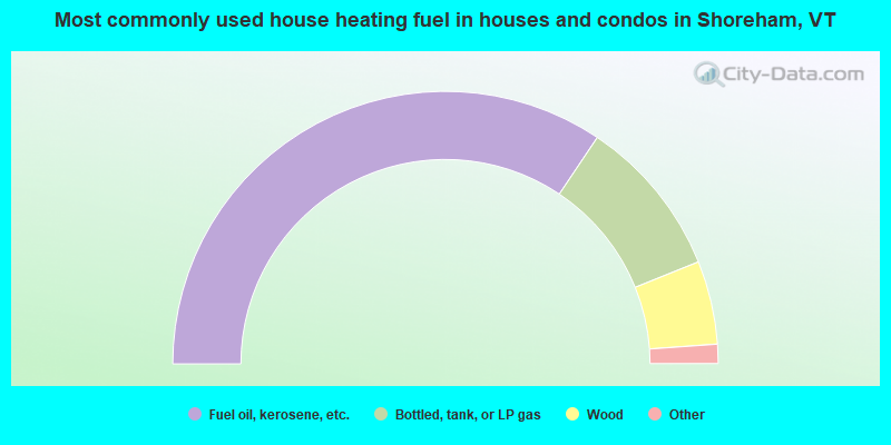
- 68.8%Fuel oil, kerosene, etc.
- 19.0%Bottled, tank, or LP gas
- 9.9%Wood
- 1.7%Coal or coke
- 0.6%Electricity
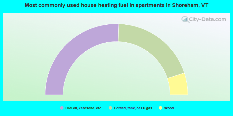
- 51.0%Fuel oil, kerosene, etc.
- 39.0%Bottled, tank, or LP gas
- 10.0%Wood
Shoreham compared to Vermont state average:
- Unemployed percentage significantly below state average.
- Foreign-born population percentage below state average.
- Renting percentage below state average.
- Length of stay since moving in significantly above state average.
- Number of rooms per house significantly below state average.
- House age significantly below state average.
- Number of college students below state average.