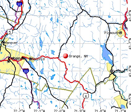
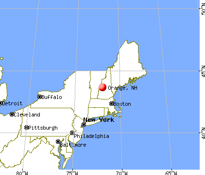
Orange, New Hampshire
Submit your own pictures of this town and show them to the world
- OSM Map
- General Map
- Google Map
- MSN Map
Population change since 2000: +10.7%
 |
| Males: 168 | |
| Females: 163 |
| Median resident age: | 42.9 years |
| New Hampshire median age: | 43.9 years |
Zip codes: 03741.
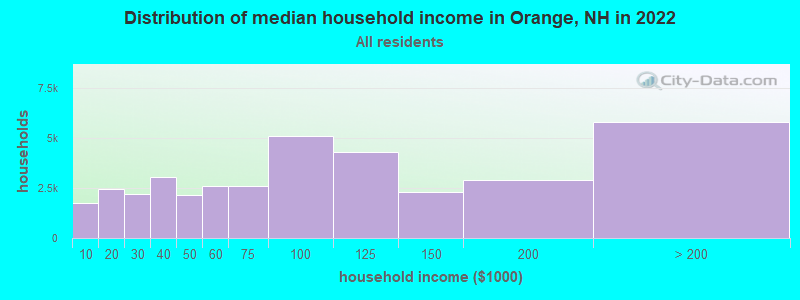
| Orange: | $80,653 |
| NH: | $89,992 |
Estimated per capita income in 2022: $39,695 (it was $17,456 in 2000)
Orange town income, earnings, and wages data
Estimated median house or condo value in 2022: $354,462 (it was $110,900 in 2000)
| Orange: | $354,462 |
| NH: | $384,700 |
Mean prices in 2022: all housing units: $486,096; detached houses: $533,852; townhouses or other attached units: $375,744; in 2-unit structures: $230,260; in 3-to-4-unit structures: $242,363; in 5-or-more-unit structures: $588,257; mobile homes: $127,035
Detailed information about poverty and poor residents in Orange, NH
Compare current foreclosures near Orange, NH:
| Photo | Address | Area | Beds / Baths | Price | Details |
|---|---|---|---|---|---|

|
#1
N Shore Rd
Hebron, NH 03241
|
3,352 sq. feet
|
4 baths 4 beds |
show details | |

|
#2
Hallelujah Ave
Rumney, NH 03266
|
981 sq. feet
|
1 baths 1 beds |
show details | |

|
#3
Daniels Dr
Enfield, NH 03748
|
636 sq. feet
|
1 baths 2 beds |
show details | |

|
#4
Knights Hill Rd
New London, NH 03257
|
3,024 sq. feet
|
2 baths 4 beds |
show details | |

|
#5
Orchard Rd
Enfield, NH 03748
|
1,056 sq. feet
|
2 baths 2 beds |
show details | |

|
#6
Bank Street Ext
Lebanon, NH 03766
|
1,232 sq. feet
|
1 baths 4 beds |
show details | |

|
#7
Slab City Rd
Grafton, NH 03240
|
- sq. feet
|
- baths - beds |
show details | |

|
#8
Renihan Mdws
Lebanon, NH 03766
|
- sq. feet
|
- baths - beds |
show details | |

|
#9
Us Route 4, Unit 5
Enfield, NH 03748
|
- sq. feet
|
- baths - beds |
show details | |

|
#10
Lake St Apt 1
Bristol, NH 03222
|
- sq. feet
|
- baths - beds |
show details |
| Photo | Address | Area | Beds / Baths | Price | Details |
|---|---|---|---|---|---|

|
#11
N Main St
Bristol, NH 03222
|
- sq. feet
|
- baths - beds |
show details | |

|
#12
Bowman Rd
Springfield, NH 03284
|
- sq. feet
|
- baths - beds |
show details | |

|
#13
Streeter Woods Rd
Rumney, NH 03266
|
- sq. feet
|
- baths - beds |
show details | |

|
#14
New Hebron Rd
Plymouth, NH 03264
|
- sq. feet
|
- baths - beds |
show details | |

|
#15
Church St
Lebanon, NH 03766
|
- sq. feet
|
- baths - beds |
show details | |

|
#16
Nh Route 4a
Wilmot, NH 03287
|
- sq. feet
|
- baths - beds |
show details | |

|
#17
Mayhew Tpke
Plymouth, NH 03264
|
- sq. feet
|
- baths - beds |
show details | |

|
#18
Fairgrounds Rd
Plymouth, NH 03264
|
- sq. feet
|
- baths - beds |
show details | |

|
#19
Snow Rd
Hill, NH 03243
|
- sq. feet
|
- baths - beds |
show details | |

|
#20
Ragged Mountain Rd
Danbury, NH 03230
|
- sq. feet
|
- baths - beds |
show details |
| Photo | Address | Area | Beds / Baths | Price | Details |
|---|---|---|---|---|---|

|
#21
Pine Meadow Rd
New Hampton, NH 03256
|
- sq. feet
|
- baths - beds |
show details | |

|
Check over 1 million property listings on Foreclosure.com!
|
browse all offers | |||

- 31896.1%White alone
- 92.7%Hispanic
- 10.3%Black alone
- 10.3%Asian alone
- 10.3%Other race alone
- 10.3%Two or more races

Races in Orange detailed stats: ancestries, foreign born residents, place of birth
According to our research of New Hampshire and other state lists, there was 1 registered sex offender living in Orange, New Hampshire as of June 03, 2024.
The ratio of all residents to sex offenders in Orange is 331 to 1.
 Recent articles from our blog. Our writers, many of them Ph.D. graduates or candidates, create easy-to-read articles on a wide variety of topics.

 | Country (2019 replies) |
| Currently researching solar panels for our house (31 replies) |
| So ashamed of my state (330 replies) |
| Seacoast- In Depth (26 replies) |
| Thinking of moving to New Hampshire from WA (40 replies) |
| NH Primary season (3 replies) |
Latest news from Orange, NH collected exclusively by city-data.com from local newspapers, TV, and radio stations
Ancestries: English (38.5%), French (27.8%), Irish (19.4%), Scottish (11.0%), German (8.0%), French Canadian (6.0%).
Current Local Time: EST time zone
Incorporated in 1790
Elevation: 1214 feet
Land area: 23.2 square miles.
Population density: 14 people per square mile (very low).
8 residents are foreign born (1.7% Europe, 1.0% Latin America).
| This town: | 2.7% |
| New Hampshire: | 4.4% |
| Orange town: | 1.7% ($1,833) |
| New Hampshire: | 2.3% ($2,946) |
Nearest city with pop. 50,000+: Manchester, NH  (52.7 miles , pop. 107,006).
Nearest city with pop. 200,000+: Boston, MA (102.1 miles , pop. 589,141).
Nearest city with pop. 1,000,000+: Bronx, NY (217.3 miles , pop. 1,332,650).
Nearest cities:
), ), Latitude: 43.65 N, Longitude: 71.96 W
Area code commonly used in this area: 603

Single-family new house construction building permits:
- 2022: 1 building, cost: $279,200
- 2020: 1 building, cost: $248,200
- 2019: 1 building, cost: $282,200
- 2018: 1 building, cost: $249,800
- 2017: 1 building, cost: $248,100
- 2016: 1 building, cost: $246,000
- 2014: 1 building, cost: $211,200
- 2013: 1 building, cost: $100,000
- 2008: 1 building, cost: $200,000
- 2007: 1 building, cost: $181,200
- 2006: 1 building, cost: $50,000
- 2005: 1 building, cost: $50,000
- 2004: 1 building, cost: $50,000
- 2003: 1 building, cost: $50,000
- 2002: 3 buildings, average cost: $121,400
- 2001: 3 buildings, average cost: $121,400
- 2000: 1 building, cost: $78,000
- 1999: 1 building, cost: $100,300
- 1998: 2 buildings, average cost: $120,200
- 1997: 2 buildings, average cost: $91,700


| Here: | 2.9% |
| New Hampshire: | 2.5% |


- Health care (13.1%)
- Educational services (10.1%)
- Construction (9.5%)
- Metal & metal products (6.0%)
- Public administration (5.4%)
- Agriculture, forestry, fishing & hunting (4.8%)
- Miscellaneous manufacturing (4.8%)

- Construction (15.5%)
- Metal & metal products (8.7%)
- Health care (8.7%)
- Public administration (7.8%)
- Agriculture, forestry, fishing & hunting (4.9%)
- Publishing, motion picture & sound recording industries (4.9%)
- Real estate & rental & leasing (4.9%)

- Health care (20.0%)
- Educational services (18.5%)
- Miscellaneous manufacturing (7.7%)
- Food & beverage stores (6.2%)
- Accommodation & food services (6.2%)
- Agriculture, forestry, fishing & hunting (4.6%)
- Used merchandise, gift, novelty, souvenir, other miscellaneous stores (4.6%)

- Driver/sales workers and truck drivers (6.5%)
- Other production occupations, including supervisors (6.5%)
- Other management occupations, except farmers and farm managers (6.0%)
- Metal workers and plastic workers (6.0%)
- Cooks and food preparation workers (3.6%)
- Carpenters (3.6%)
- Material recording, scheduling, dispatching, and distributing workers (3.6%)

- Driver/sales workers and truck drivers (10.7%)
- Other management occupations, except farmers and farm managers (9.7%)
- Metal workers and plastic workers (9.7%)
- Carpenters (5.8%)
- Electrical equipment mechanics and other installation, maintenance, and repair workers, including supervisors (5.8%)
- Postsecondary teachers (4.9%)
- Construction traders workers except carpenters, electricians, painters, plumbers, and construction laborers (4.9%)

- Cooks and food preparation workers (9.2%)
- Other production occupations, including supervisors (9.2%)
- Financial clerks, except bookkeeping, accounting and auditing clerks (7.7%)
- Cashiers (6.2%)
- Preschool, kindergarten, elementary, and middle school teachers (4.6%)
- Building and grounds cleaning and maintenance occupations (4.6%)
- Counselors, social workers, and other community and social service specialists (4.6%)
Average climate in Orange, New Hampshire
Based on data reported by over 4,000 weather stations


(lower is better)

Air Quality Index (AQI) level in 2022 was 52.5. This is better than average.
| City: | 52.5 |
| U.S.: | 72.6 |

Ozone [ppb] level in 2022 was 26.2. This is better than average. Closest monitor was 13.5 miles away from the city center.
| City: | 26.2 |
| U.S.: | 33.3 |

Particulate Matter (PM2.5) [µg/m3] level in 2022 was 5.19. This is significantly better than average. Closest monitor was 15.5 miles away from the city center.
| City: | 5.19 |
| U.S.: | 8.11 |
Tornado activity:
Orange-area historical tornado activity is slightly below New Hampshire state average. It is 64% smaller than the overall U.S. average.
On 5/11/1973, a category F2 (max. wind speeds 113-157 mph) tornado 5.7 miles away from the Orange town center .
On 8/11/1966, a category F2 tornado 25.0 miles away from the town center caused between $50,000 and $500,000 in damages.
Earthquake activity:
Orange-area historical earthquake activity is significantly above New Hampshire state average. It is 71% smaller than the overall U.S. average.On 4/20/2002 at 10:50:47, a magnitude 5.3 (5.3 ML, Depth: 3.0 mi, Class: Moderate, Intensity: VI - VII) earthquake occurred 104.8 miles away from Orange center
On 10/7/1983 at 10:18:46, a magnitude 5.3 (5.1 MB, 5.3 LG, 5.1 ML) earthquake occurred 120.6 miles away from Orange center
On 4/20/2002 at 10:50:47, a magnitude 5.2 (5.2 MB, 4.2 MS, 5.2 MW, 5.0 MW) earthquake occurred 104.6 miles away from the city center
On 1/19/1982 at 00:14:42, a magnitude 4.7 (4.5 MB, 4.7 MD, 4.5 LG, Class: Light, Intensity: IV - V) earthquake occurred 21.0 miles away from the city center
On 10/16/2012 at 23:12:25, a magnitude 4.7 (4.7 ML, Depth: 10.0 mi) earthquake occurred 65.5 miles away from Orange center
On 6/16/1995 at 12:13:11, a magnitude 3.8 (3.8 LG, Depth: 3.1 mi, Class: Light, Intensity: II - III) earthquake occurred 43.9 miles away from Orange center
Magnitude types: regional Lg-wave magnitude (LG), body-wave magnitude (MB), duration magnitude (MD), local magnitude (ML), surface-wave magnitude (MS), moment magnitude (MW)
Natural disasters:
The number of natural disasters in Grafton County (32) is a lot greater than the US average (15).Major Disasters (Presidential) Declared: 20
Emergencies Declared: 9
Causes of natural disasters: Floods: 16, Storms: 16, Hurricanes: 3, Snows: 3, Winter Storms: 3, Tropical Storms: 2, Blizzard: 1, Heavy Rain: 1, Ice Storm: 1, Landslide: 1, Snowfall: 1, Snowstorm: 1, Wind: 1, Other: 1 (Note: some incidents may be assigned to more than one category).
Hospitals and medical centers near Orange:
- NEWFOUND AREA NURSING ASSN (Home Health Center, about 12 miles away; BRISTOL, NH)
- FRESENIUS MEDICAL CARE OF LEBANON (Dialysis Facility, about 14 miles away; LEBANON, NH)
- SPEARE MEMORIAL HOSPITAL Critical Access Hospitals (about 16 miles away; PLYMOUTH, NH)
- LAKE SUNAPEE REGION VNA (Home Health Center, about 16 miles away; NEW LONDON, NH)
Amtrak station near Orange:
Colleges/universities with over 2000 students nearest to Orange:
- Plymouth State University (about 16 miles; Plymouth, NH; Full-time enrollment: 4,838)
- Dartmouth College (about 17 miles; Hanover, NH; FT enrollment: 6,030)
- NHTI-Concord's Community College (about 37 miles; Concord, NH; FT enrollment: 2,865)
- Norwich University (about 49 miles; Northfield, VT; FT enrollment: 4,221)
- Southern New Hampshire University (about 50 miles; Manchester, NH; FT enrollment: 16,552)
- Saint Anselm College (about 52 miles; Manchester, NH; FT enrollment: 2,059)
- Keene State College (about 53 miles; Keene, NH; FT enrollment: 5,098)
Points of interest:
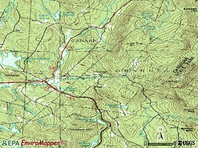
Cemetery: Orange Common Cemetery (1). Display/hide its location on the map
Lakes: Derby Pond (A), Orange Pond (B). Display/hide their locations on the map
Streams, rivers, and creeks: Number Seven Brook (A). Display/hide its location on the map
Park in Orange: Mount Cardigan State Park (1). Display/hide its location on the map
| This town: | 2.5 people |
| New Hampshire: | 2.5 people |
| This town: | 63.6% |
| Whole state: | 66.3% |
| This town: | 12.9% |
| Whole state: | 8.3% |
Likely homosexual households (counted as self-reported same-sex unmarried-partner households)
- Lesbian couples: 1.5% of all households
- Gay men: 2.3% of all households
| This town: | 6.6% |
| Whole state: | 6.5% |
| This town: | 6.3% |
| Whole state: | 2.8% |
For population 15 years and over in Orange:

- Never married: 24.4%
- Now married: 51.7%
- Separated: 1.2%
- Widowed: 5.0%
- Divorced: 17.8%
For population 25 years and over in Orange:
- High school or higher: 77.1%
- Bachelor's degree or higher: 17.4%
- Graduate or professional degree: 7.3%
- Unemployed: 3.4%
- Mean travel time to work (commute): 31.5 minutes


| Here: | 12.7 |
| New Hampshire average: | 10.9 |


Graphs represent county-level data. Detailed 2008 Election Results
Religion statistics for Orange, NH (based on Grafton County data)


| Religion | Adherents | Congregations |
|---|---|---|
| Catholic | 9,503 | 12 |
| Mainline Protestant | 7,832 | 57 |
| Evangelical Protestant | 1,494 | 29 |
| Other | 1,320 | 11 |
| None | 68,969 | - |
Food Environment Statistics:
| This county: | 3.87 / 10,000 pop. |
| State: | 2.14 / 10,000 pop. |
| Here: | 0.23 / 10,000 pop. |
| New Hampshire: | 0.15 / 10,000 pop. |
| Grafton County: | 1.29 / 10,000 pop. |
| New Hampshire: | 1.78 / 10,000 pop. |
| Grafton County: | 6.45 / 10,000 pop. |
| New Hampshire: | 4.02 / 10,000 pop. |
| This county: | 14.41 / 10,000 pop. |
| New Hampshire: | 9.70 / 10,000 pop. |
| This county: | 7.2% |
| New Hampshire: | 7.6% |
| Grafton County: | 22.9% |
| New Hampshire: | 24.4% |
| Grafton County: | 15.9% |
| New Hampshire: | 15.9% |
Strongest AM radio stations in Orange:
- WNTK (1020 AM; 10 kW; NEWPORT, NH; Owner: KOOR COMMUNICATIONS, INC.)
- WPNH (1300 AM; 5 kW; PLYMOUTH, NH; Owner: NORTHEAST COMMUNICATIONS CORPORATION)
- WRKO (680 AM; 50 kW; BOSTON, MA; Owner: ENTERCOM BOSTON LICENSE, LLC)
- WEZS (1350 AM; 5 kW; LACONIA, NH; Owner: GARY W. HAMMOND)
- WCRN (830 AM; 50 kW; WORCESTER, MA; Owner: CARTER BROADCASTING CORPORATION)
- WNNZ (640 AM; 50 kW; WESTFIELD, MA; Owner: CLEAR CHANNEL BROADCASTING LICENSES, INC.)
- WEEI (850 AM; 50 kW; BOSTON, MA; Owner: ENTERCOM BOSTON LICENSE, LLC)
- WKOX (1200 AM; 50 kW; FRAMINGHAM, MA; Owner: CAPSTAR TX LIMITED PARTNERSHIP)
- WGY (810 AM; 50 kW; SCHENECTADY, NY; Owner: CLEAR CHANNEL BROADCASTING LICENSES, INC.)
- WBZ (1030 AM; 50 kW; BOSTON, MA; Owner: INFINITY BROADCASTING OPERATIONS, INC.)
- WBIX (1060 AM; 40 kW; NATICK, MA; Owner: LANGER BROADCASTING CORPORATION)
- WTWN (1100 AM; daytime; 5 kW; WELLS RIVER, VT; Owner: PUFFER BROADCASTING, INC.)
- WWZN (1510 AM; 50 kW; BOSTON, MA; Owner: ROSE CITY RADIO CORPORATION)
Strongest FM radio stations in Orange:
- WPNH-FM (100.1 FM; PLYMOUTH, NH; Owner: NORTHEAST COMMUNICATIONS CORPORATION)
- WEVH (91.3 FM; HANOVER, NH; Owner: NEW HAMPSHIRE PUBLIC RADIO INC)
- WHDQ (106.1 FM; CLAREMONT, NH; Owner: GREAT NORTHERN RADIO, L.L.C.)
- WVPR (89.5 FM; WINDSOR, VT; Owner: VERMONT PUBLIC RADIO)
- WVFM (105.7 FM; CAMPTON, NH; Owner: DEVON BROADCASTING COMPANY, INC.)
- WNTK-FM (99.7 FM; NEW LONDON, NH; Owner: SHEILA E. VINIKOOR)
- WSCY (106.9 FM; MOULTONBOROUGH, NH; Owner: NORTHEAST COMMUNICATIONS CORPORATION)
- WPKQ (103.7 FM; NORTH CONWAY, NH; Owner: CITADEL BROADCASTING COMPANY)
- WHOM (94.9 FM; MT. WASHINGTON, NH; Owner: CITADEL BROADCASTING COMPANY)
- WJJR (98.1 FM; RUTLAND, VT; Owner: 6 JOHNSON ROAD LICENSES, INC.)
- WZRT (97.1 FM; RUTLAND, VT; Owner: CAPSTAR TX LIMITED PARTNERSHIP)
- WEBK (105.3 FM; KILLINGTON, VT; Owner: 6 JOHNSON ROAD LICENSES, INC.)
- WXXK (100.5 FM; LEBANON, NH; Owner: CAPSTAR TX LIMITED PARTNERSHIP)
- WVRR (101.7 FM; NEWPORT, NH; Owner: CAPSTAR TX LIMITED PARTNERSHIP)
- WGLV (91.7 FM; WOODSTOCK, VT; Owner: CHRISTIAN MINISTRIES INC)
- WHDQ-FM1 (106.1 FM; RUTLAND, VT; Owner: GREAT NORTHERN RADIO, L.L.C.)
- WNHI (93.3 FM; BELMONT, NH; Owner: CONCORD BROADCASTING, L.L.C.)
- WLKZ (104.9 FM; WOLFEBORO, NH; Owner: TELE-MEDIA COMPANY OF NEW HAMPSHIRE, L.L.C.)
- WDEV-FM (96.1 FM; WARREN, VT; Owner: RADIO VERMONT, INC.)
- WRJT (103.1 FM; ROYALTON, VT; Owner: LISBON COMMUNICATIONS, INC.)
TV broadcast stations around Orange:
- W15BK (Channel 15; HANOVER, NH; Owner: UNIVERSITY OF NEW HAMPSHIRE)
- National Bridge Inventory (NBI) Statistics
- 2Number of bridges
- 7ft / 2.4mTotal length
- $6,284,000Total costs
- 197Total average daily traffic
- 7Total average daily truck traffic
- 290Total future (year 2042) average daily traffic
FCC Registered Broadcast Land Mobile Towers:
1- Cardigan Mountain Lookout Sta (Lat: 43.649806 Lon: -71.913972), Type: Bant, Structure height: 10 m, Call Sign: KCD842,
Assigned Frequencies: 31.9000 MHz, Grant Date: 08/23/2022, Expiration Date: 11/18/2032, Registrant: Nh Dncr, 172 Pembroke Road, Concord, NH 03301, Phone: (603) 271-2654, Fax: (603) 271-6488, Email:
FCC Registered Amateur Radio Licenses:
6- Call Sign: KB1FJJ, Licensee ID: L00262165, Grant Date: 05/13/2020, Expiration Date: 06/22/2030, Cancellation Date: 05/27/2020, Certifier: Alexander G Smith, Registrant: Alexander G Smith, 50 Tug Mountain Road, Orange, NH 03741
- Call Sign: KC1CKP, Licensee ID: L01886119, Grant Date: 08/20/2014, Expiration Date: 08/20/2024, Certifier: Donald S Mcfarlane, Registrant: Donald S Mcfarlane, 280 Burnt Hill Rd, Orange, NH 03741
- Call Sign: AC1JF, Licensee ID: L02334524, Grant Date: 03/18/2020, Expiration Date: 03/18/2030, Cancellation Date: 05/16/2020, Certifier: Alasdair G Dunlap-Smith, Registrant: Alasdair G Dunlap-Smith, 50 Tug Mountian Rd, Orange, NH 03741
- Call Sign: W1UC, Previous Call Sign: AC1JF, Licensee ID: L02334524, Grant Date: 05/16/2020, Expiration Date: 05/16/2030, Certifier: Alasdair G Dunlap-Smith, Registrant: Alasdair G Dunlap-Smith, 50 Tug Mountain Rd, Orange, NH 03741
- Call Sign: W1FET, Previous Call Sign: KB1FJJ, Licensee ID: L00262165, Grant Date: 05/27/2020, Expiration Date: 05/27/2030, Certifier: Alexander G Smith, Registrant: Alexander G Smith, 50 Tug Mountain Road, Orange, NH 03741
- Call Sign: KC1OBJ, Licensee ID: L02386615, Grant Date: 10/23/2020, Expiration Date: 10/23/2030, Certifier: Jason C Azze, Registrant: Jason C Azze, 25 Cardigan Mountain Rd, Orange, NH 03741
Orange compared to New Hampshire state average:
- Unemployed percentage significantly below state average.
- Black race population percentage significantly below state average.
- Foreign-born population percentage below state average.
- Renting percentage significantly below state average.
- Length of stay since moving in significantly above state average.
- Number of rooms per house significantly below state average.
- House age significantly below state average.
- Number of college students below state average.
- Percentage of population with a bachelor's degree or higher below state average.

|
Total of 7 patent applications in 2008-2024.