Oma, Wisconsin
Submit your own pictures of this town and show them to the world
- OSM Map
- Google Map
- MSN Map
Population change since 2000: -18.6%
 |
| Males: 146 | |
| Females: 143 |
| Median resident age: | 55.4 years |
| Wisconsin median age: | 42.6 years |
Zip codes: 54547.
| Oma: | $57,122 |
| WI: | $70,996 |
Estimated per capita income in 2022: $32,271 (it was $16,146 in 2000)
Oma town income, earnings, and wages data
Estimated median house or condo value in 2022: $212,024 (it was $86,600 in 2000)
| Oma: | $212,024 |
| WI: | $252,800 |
Mean prices in 2022: all housing units: $231,545; detached houses: $237,798; townhouses or other attached units: $114,627; in 2-unit structures: $45,407; in 3-to-4-unit structures: $106,715; in 5-or-more-unit structures: $145,737; mobile homes: $98,744
Detailed information about poverty and poor residents in Oma, WI


 Recent articles from our blog. Our writers, many of them Ph.D. graduates or candidates, create easy-to-read articles on a wide variety of topics.
Ancestries: German (25.4%), Italian (16.9%), Irish (13.8%), Polish (11.3%), French (6.8%), Swedish (6.8%).
Current Local Time: CST time zone
Land area: 74.7 square miles.
Population density: 3.9 people per square mile (very low).
4 residents are foreign born
| This town: | 1.1% |
| Wisconsin: | 3.6% |
| Oma town: | 1.7% ($1,484) |
| Wisconsin: | 2.0% ($2,245) |
Nearest city with pop. 50,000+: Duluth, MN  (104.1 miles , pop. 86,918).
Nearest city with pop. 200,000+: St. Paul, MN (174.2 miles , pop. 287,151).
Nearest city with pop. 1,000,000+: Chicago, IL (329.0 miles , pop. 2,896,016).
Nearest cities:
)Latitude: 46.28 N, Longitude: 90.05 W

| Here: | 5.4% |
| Wisconsin: | 2.7% |

- Accommodation & food services (14.1%)
- Health care (11.3%)
- Construction (9.2%)
- Educational services (8.5%)
- Agriculture, forestry, fishing & hunting (7.7%)
- Public administration (7.0%)
- Building material & garden equipment & supplies dealers (4.9%)

- Agriculture, forestry, fishing & hunting (11.4%)
- Construction (11.4%)
- Building material & garden equipment & supplies dealers (10.0%)
- Accommodation & food services (10.0%)
- Public administration (7.1%)
- Real estate & rental & leasing (5.7%)
- Health care (5.7%)

- Accommodation & food services (18.1%)
- Health care (16.7%)
- Educational services (13.9%)
- Construction (6.9%)
- Public administration (6.9%)
- Finance & insurance (6.9%)
- Agriculture, forestry, fishing & hunting (4.2%)

- Other management occupations, except farmers and farm managers (8.5%)
- Other sales and related occupations, including supervisors (6.3%)
- Driver/sales workers and truck drivers (5.6%)
- Preschool, kindergarten, elementary, and middle school teachers (4.9%)
- Secretaries and administrative assistants (4.9%)
- Cooks and food preparation workers (4.9%)
- Information and record clerks, except customer service representatives (3.5%)

- Other management occupations, except farmers and farm managers (14.3%)
- Driver/sales workers and truck drivers (11.4%)
- Other sales and related occupations, including supervisors (10.0%)
- Health technologists and technicians (5.7%)
- Other protective service workers, including supervisors (5.7%)
- Construction traders workers except carpenters, electricians, painters, plumbers, and construction laborers (5.7%)
- Fire fighting and prevention workers, including supervisors (4.3%)

- Preschool, kindergarten, elementary, and middle school teachers (9.7%)
- Cooks and food preparation workers (9.7%)
- Secretaries and administrative assistants (9.7%)
- Information and record clerks, except customer service representatives (6.9%)
- Food and beverage serving workers, except waiters and waitresses (5.6%)
- Registered nurses (5.6%)
- Bookkeeping, accounting, and auditing clerks (5.6%)
Average climate in Oma, Wisconsin
Based on data reported by over 4,000 weather stations


(lower is better)

Air Quality Index (AQI) level in 2022 was 53.8. This is better than average.
| City: | 53.8 |
| U.S.: | 72.6 |

Sulfur Dioxide (SO2) [ppb] level in 2003 was 1.94. This is worse than average. Closest monitor was 22.7 miles away from the city center.
| City: | 1.94 |
| U.S.: | 1.51 |

Ozone [ppb] level in 2022 was 31.5. This is about average. Closest monitor was 14.7 miles away from the city center.
| City: | 31.5 |
| U.S.: | 33.3 |

Particulate Matter (PM2.5) [µg/m3] level in 2022 was 4.92. This is significantly better than average. Closest monitor was 24.9 miles away from the city center.
| City: | 4.92 |
| U.S.: | 8.11 |

Lead (Pb) [µg/m3] level in 2002 was 0.00227. This is significantly better than average. Closest monitor was 24.9 miles away from the city center.
| City: | 0.00227 |
| U.S.: | 0.00931 |
Tornado activity:
Oma-area historical tornado activity is significantly below Wisconsin state average. It is 71% smaller than the overall U.S. average.
On 4/27/1984, a category F3 (max. wind speeds 158-206 mph) tornado 30.3 miles away from the Oma town center killed one person and injured 8 people and caused between $5,000,000 and $50,000,000 in damages.
On 6/8/1985, a category F3 tornado 31.5 miles away from the town center killed 2 people and injured 42 people and caused between $5,000,000 and $50,000,000 in damages.
Earthquake activity:
Oma-area historical earthquake activity is significantly above Wisconsin state average. It is 76% smaller than the overall U.S. average.On 7/9/1975 at 14:54:15, a magnitude 4.6 (4.6 MB, Class: Light, Intensity: IV - V) earthquake occurred 290.8 miles away from the city center
On 3/2/2017 at 16:53:31, a magnitude 3.2 (3.2 ML, Class: Light, Intensity: II - III) earthquake occurred 129.6 miles away from the city center
On 2/7/2020 at 18:30:28, a magnitude 3.3 (3.3 ML) earthquake occurred 151.0 miles away from the city center
On 4/8/2020 at 17:14:33, a magnitude 3.3 (3.3 ML) earthquake occurred 151.3 miles away from the city center
On 1/9/2020 at 18:16:48, a magnitude 3.3 (3.3 MB) earthquake occurred 151.9 miles away from Oma center
On 6/5/1993 at 01:24:53, a magnitude 4.1 (4.1 LG, Depth: 6.2 mi) earthquake occurred 302.7 miles away from Oma center
Magnitude types: regional Lg-wave magnitude (LG), body-wave magnitude (MB), local magnitude (ML)
Natural disasters:
The number of natural disasters in Iron County (11) is smaller than the US average (15).Major Disasters (Presidential) Declared: 8
Emergencies Declared: 2
Causes of natural disasters: Floods: 8, Storms: 5, Winds: 3, Tornadoes: 2, Drought: 1, Heavy Rain: 1, Hurricane: 1, Landslide: 1, Other: 1 (Note: some incidents may be assigned to more than one category).
Hospitals and medical centers near Oma:
- VILLA MARIA HEALTH AND REHAB CTR (Nursing Home, about 13 miles away; HURLEY, WI)
- SKY VIEW NURSING CENTER (Nursing Home, about 14 miles away; HURLEY, WI)
- JOSEPHSON NURSING HOME (Nursing Home, about 14 miles away; IRONWOOD, MI)
- GOGEBIC MEDICAL CARE FACILITY (Nursing Home, about 14 miles away; WAKEFIELD, MI)
- WESTGATE NURSING AND REHAB COMMUNITY (Nursing Home, about 14 miles away; IRONWOOD, MI)
Colleges/universities with over 2000 students nearest to Oma:
- Northcentral Technical College (about 92 miles; Wausau, WI; Full-time enrollment: 3,356)
- Michigan Technological University (about 92 miles; Houghton, MI; FT enrollment: 6,078)
- Wisconsin Indianhead Technical College (about 97 miles; Shell Lake, WI; FT enrollment: 2,414)
- University of Wisconsin-Superior (about 102 miles; Superior, WI; FT enrollment: 2,302)
- University of Minnesota-Duluth (about 104 miles; Duluth, MN; FT enrollment: 10,612)
- The College of Saint Scholastica (about 105 miles; Duluth, MN; FT enrollment: 3,762)
- Lake Superior College (about 106 miles; Duluth, MN; FT enrollment: 3,768)
Points of interest:
Notable locations in Oma: Sandrock (A), Oma Volunteer Fire Department (B). Display/hide their locations on the map
Church in Oma: Finnish Church (A). Display/hide its location on the map
Lakes and swamps: Negro Lakes (A), Oak Lake (B), Oriole Lake (C), Otter Lake (D), Owl Lake (E), Pardee Lake (F), Pine Lake (G), Spinnet Lake (H). Display/hide their locations on the map
Rivers and creeks: Sandrock Creek (A), Laymans Creek (B), Pardee Creek (C), Virgin Creek (D), Lake One Creek (E), South Fork Black River (F). Display/hide their locations on the map
Parks in Oma include: Lake Evelyn State Natural Area (1), Oma Park (2), Schomberg County Park (3), Underwood State Wildlife Area (4). Display/hide their locations on the map
| This town: | 2.1 people |
| Wisconsin: | 2.4 people |
| This town: | 65.0% |
| Whole state: | 64.4% |
| This town: | 5.1% |
| Whole state: | 7.3% |
Likely homosexual households (counted as self-reported same-sex unmarried-partner households)
- Lesbian couples: 1.5% of all households
- Gay men: 0.0% of all households
| This town: | 16.1% |
| Whole state: | 8.7% |
For population 15 years and over in Oma:

- Never married: 10.6%
- Now married: 71.1%
- Separated: 1.1%
- Widowed: 8.7%
- Divorced: 8.4%
For population 25 years and over in Oma:
- High school or higher: 84.7%
- Bachelor's degree or higher: 15.3%
- Graduate or professional degree: 1.2%
- Unemployed: 7.8%
- Mean travel time to work (commute): 21.9 minutes


| Here: | 7.9 |
| Wisconsin average: | 11.0 |
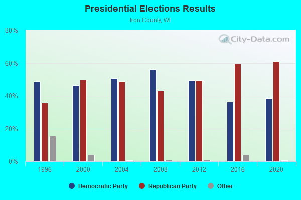
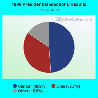
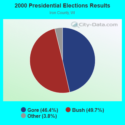


Graphs represent county-level data. Detailed 2008 Election Results
Religion statistics for Oma, WI (based on Iron County data)
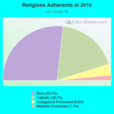
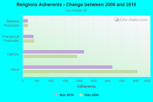
| Religion | Adherents | Congregations |
|---|---|---|
| Catholic | 2,173 | 3 |
| Evangelical Protestant | 388 | 6 |
| Mainline Protestant | 181 | 3 |
| None | 3,174 | - |
Food Environment Statistics:
| This county: | 3.18 / 10,000 pop. |
| Wisconsin: | 1.86 / 10,000 pop. |
| Here: | 11.13 / 10,000 pop. |
| Wisconsin: | 4.12 / 10,000 pop. |
| This county: | 23.85 / 10,000 pop. |
| State: | 8.64 / 10,000 pop. |
| Here: | 8.9% |
| Wisconsin: | 7.6% |
| This county: | 26.7% |
| Wisconsin: | 27.5% |
| This county: | 13.1% |
| Wisconsin: | 13.0% |
Strongest AM radio stations in Oma:
- WJMS (590 AM; 5 kW; IRONWOOD, MI; Owner: ROBERTS BROADCASTING, INC.)
- WEBC (560 AM; 50 kW; DULUTH, MN)
- WHRY (1450 AM; 1 kW; HURLEY, WI; Owner: BIG G LITTLE O INC.)
- WSAU (550 AM; 20 kW; WAUSAU, WI; Owner: WRIG, INC.)
- WSPT (1010 AM; 50 kW; STEVENS POINT, WI)
- WLKD (1570 AM; 5 kW; MINOCQUA, WI; Owner: RAVEN BROADCASTING CORPORATION)
- WCCO (830 AM; 50 kW; MINNEAPOLIS, MN; Owner: INFINITY MEDIA CORPORATION)
- WCTS (1030 AM; 50 kW; MAPLEWOOD, MN; Owner: CNTL. BAPT. THEO/AL SEMI MINNEAPOLIS)
- WNAM (1280 AM; 50 kW; NEENAH-MENASHA, WI; Owner: CUMULUS LICENSING CORP.)
- WDSM (710 AM; 10 kW; SUPERIOR, WI; Owner: MIDWEST COMMUNICATIONS, INC.)
- KSTP (1500 AM; 50 kW; ST. PAUL, MN; Owner: KSTP-AM, LLC (DELAWARE))
- KFAN (1130 AM; 50 kW; MINNEAPOLIS, MN; Owner: AMFM RADIO LICENSES, L.L.C.)
- WTMJ (620 AM; 50 kW; MILWAUKEE, WI; Owner: JOURNAL BROADCAST CORPORATION)
Strongest FM radio stations in Oma:
- WIMI (99.7 FM; IRONWOOD, MI; Owner: ROBERTS BROADCASTING, INC.)
- WUPM (106.9 FM; IRONWOOD, MI; Owner: BIG G LITTLE O, INC.)
- W207BR (89.3 FM; IRONWOOD, MI; Owner: NORTHWESTERN COLLEGE)
- W280DD (103.9 FM; IRONWOOD, MI; Owner: GOSPEL OPPORTUNITIES, INC.)
- W265AI (100.9 FM; IRONWOOD, MI; Owner: WHITE PINE COMMUNITY B/C, INC.)
- WHBM-FM (90.3 FM; PARK FALLS, WI; Owner: STATE OF WISCONSIN - EDUCATIONAL COMMUNICATIONS BOARD)
- W224AW (92.7 FM; BERGLAND, MI; Owner: GOSPEL OPPORTUNITIES, INC.)
TV broadcast stations around Oma:
- WLEF-TV (Channel 36; PARK FALLS, WI; Owner: STATE OF WISCONSIN - EDUCATIONAL COMMUNICATIONS BOARD)
- WYOW (Channel 34; EAGLE RIVER, WI; Owner: WAOW-WYOW TELEVISION, INC.)
- W57AR (Channel 57; SAYNER/VILAS COUNTY, WI; Owner: GRAY MIDAMERICA TV LICENSEE CORP.)
- W31BA (Channel 31; MINOCQUA, WI; Owner: THREE ANGELS BROADCASTING NETWORK)
- National Bridge Inventory (NBI) Statistics
- 4Number of bridges
- 23ft / 6.6mTotal length
- 2,753Total average daily traffic
- 269Total average daily truck traffic
- 3,898Total future (year 2039) average daily traffic
FCC Registered Antenna Towers:
1- Brandon Yuchasz, Pine Lake , Oma , Wisconsin 54547 (Lat: 46.262194 Lon: -90.123722), Type: 50.0, Structure height: 55051 m, Overall height: 50 m, Registrant: Gogebicrange.Net LLC, Brandon@gogebicrange.Net, , Maren-isco, Phone: (906) 842-3394

- 55.0%Bottled, tank, or LP gas
- 21.4%Fuel oil, kerosene, etc.
- 18.3%Wood
- 3.8%Electricity
- 1.5%Utility gas

- 84.6%Bottled, tank, or LP gas
- 15.4%Fuel oil, kerosene, etc.
Oma compared to Wisconsin state average:
- Black race population percentage significantly below state average.
- Hispanic race population percentage significantly below state average.
- Median age significantly above state average.
- Foreign-born population percentage significantly below state average.
- Renting percentage significantly below state average.
- Length of stay since moving in significantly above state average.
- Number of rooms per house significantly below state average.
- House age significantly below state average.
- Number of college students significantly below state average.
- Percentage of population with a bachelor's degree or higher below state average.
Oma on our top lists:
- #38 on the list of "Top 100 least racially diverse cities"
- #80 on the list of "Top 101 counties with the highest number of deaths per 1000 residents 2007-2013"