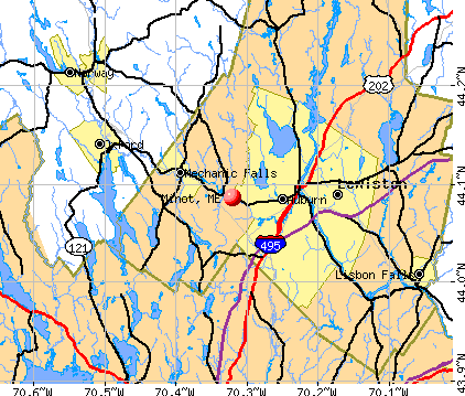
Minot, Maine

Minot: 2008-03-07

Minot: View from Castle Ledge in Minot

Minot: 2008-03-07 where's the fence??
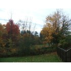
Minot: nice fall colors

Minot: wild turkeys IN the yard
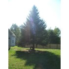
Minot: big 'ol tree

Minot
- add
your
Submit your own pictures of this town and show them to the world
- OSM Map
- General Map
- Google Map
- MSN Map
Population change since 2000: +16.0%
 |
| Males: 1,308 | |
| Females: 1,299 |
| Median resident age: | 42.3 years |
| Maine median age: | 43.0 years |
Zip codes: 04258.
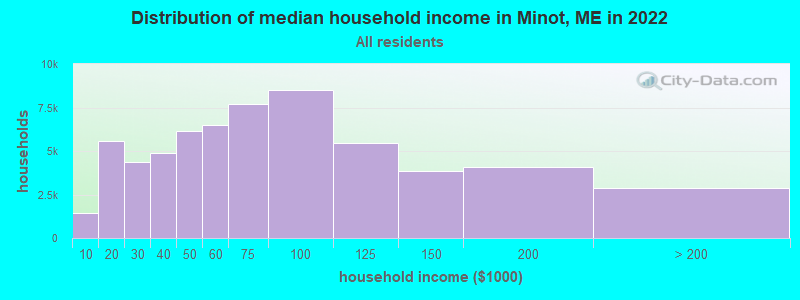
| Minot: | $84,288 |
| ME: | $69,543 |
Estimated per capita income in 2022: $32,797 (it was $18,668 in 2000)
Minot town income, earnings, and wages data
Estimated median house or condo value in 2022: $278,336 (it was $97,300 in 2000)
| Minot: | $278,336 |
| ME: | $290,600 |
Mean prices in 2022: all housing units: $249,170; detached houses: $267,476; townhouses or other attached units: $202,361; in 2-unit structures: $200,400; in 3-to-4-unit structures: $182,257; in 5-or-more-unit structures: $238,166; mobile homes: $73,615
Detailed information about poverty and poor residents in Minot, ME

Compare current foreclosures near Minot, ME:
| Photo | Address | Area | Beds / Baths | Price | Details |
|---|---|---|---|---|---|

|
#1
Shaw Hill Rd
Minot, ME 04258
|
1,008 sq. feet
|
- baths - beds |
show details | |

|
#2
Rodmar Rd
Minot, ME 04258
|
1,092 sq. feet
|
- baths - beds |
show details | |

|
#3
Upland Rd
Lisbon, ME 04250
|
714 sq. feet
|
1 baths 3 beds |
show details | |

|
#4
Frost Hill Ave
Lisbon Falls, ME 04252
|
1,952 sq. feet
|
3 baths 3 beds |
show details | |

|
#5
Brandywine Cir
Auburn, ME 04210
|
2,588 sq. feet
|
4 baths 4 beds |
show details | |

|
#6
Norway Rd
Harrison, ME 04040
|
864 sq. feet
|
1 baths 3 beds |
show details | |

|
#7
Patterson St
Lisbon, ME 04250
|
759 sq. feet
|
2 baths 2 beds |
show details | |

|
#8
Warren Ave
Lewiston, ME 04240
|
1,200 sq. feet
|
1 baths 3 beds |
show details | |

|
#9
Bluff Cir
New Gloucester, ME 04260
|
1,008 sq. feet
|
1 baths 3 beds |
show details | |

|
#10
Leach Hill Rd
Casco, ME 04015
|
4,032 sq. feet
|
1 baths 4 beds |
show details |
| Photo | Address | Area | Beds / Baths | Price | Details |
|---|---|---|---|---|---|

|
#11
Ralph Richardson Rd
Norway, ME 04268
|
1,963 sq. feet
|
2 baths 3 beds |
show details | |

|
#12
Upton Rd
Harrison, ME 04040
|
1,404 sq. feet
|
2 baths 3 beds |
show details | |

|
#13
Bartholomew St
Lisbon, ME 04250
|
1,056 sq. feet
|
2 baths 3 beds |
show details | |

|
#14
Poland Spring Rd
Casco, ME 04015
|
1,152 sq. feet
|
2 baths 2 beds |
show details | |

|
#15
Crest Ave
Lisbon, ME 04250
|
1,066 sq. feet
|
3 baths 3 beds |
show details | |

|
#16
Spring St
Lisbon, ME 04250
|
1,141 sq. feet
|
1 baths 3 beds |
show details | |

|
#17
S Hatch Hl
Greene, ME 04236
|
1,373 sq. feet
|
1 baths 3 beds |
show details | |

|
#18
Lewiston Rd
New Gloucester, ME 04260
|
1,632 sq. feet
|
2 baths 5 beds |
show details | |

|
#19
Key Hill Rd
Greene, ME 04236
|
3,300 sq. feet
|
4 baths 4 beds |
show details | |

|
#20
Lisbon St
Lisbon, ME 04250
|
988 sq. feet
|
1 baths 3 beds |
show details |
| Photo | Address | Area | Beds / Baths | Price | Details |
|---|---|---|---|---|---|

|
#21
Lewiston Rd
New Gloucester, ME 04260
|
1,715 sq. feet
|
1 baths 4 beds |
show details | |

|
#22
Wiley Rd
Greene, ME 04236
|
1,420 sq. feet
|
1 baths 3 beds |
show details | |

|
#23
Brook St
Oxford, ME 04270
|
1,064 sq. feet
|
2 baths 3 beds |
show details | |

|
#24
Tenney Hill Rd
Casco, ME 04015
|
798 sq. feet
|
1 baths 3 beds |
show details | |

|
#25
Vivian St
Auburn, ME 04210
|
1,523 sq. feet
|
2 baths 5 beds |
show details | |

|
#26
Turkey Ln
Casco, ME 04015
|
816 sq. feet
|
2 baths 2 beds |
show details | |

|
#27
Hotel Rd
Auburn, ME 04210
|
920 sq. feet
|
1 baths 2 beds |
show details | |

|
#28
Colley Hill Rd
Gray, ME 04039
|
2,596 sq. feet
|
3 baths 3 beds |
show details | |

|
#29
Elm St
Mechanic Falls, ME 04256
|
1,872 sq. feet
|
2 baths 3 beds |
show details | |

|
#30
High St
Lisbon Falls, ME 04252
|
1,288 sq. feet
|
2 baths 4 beds |
show details |
| Photo | Address | Area | Beds / Baths | Price | Details |
|---|---|---|---|---|---|

|
#31
Woodlawn Ave
Auburn, ME 04210
|
1,176 sq. feet
|
2 baths 3 beds |
show details | |

|
#32
Pleasant St
Lisbon Falls, ME 04252
|
561 sq. feet
|
2 baths 2 beds |
show details | |

|
#33
Carsley Rd
Harrison, ME 04040
|
1,008 sq. feet
|
2 baths 3 beds |
show details | |

|
#34
Summit St
Auburn, ME 04210
|
2,344 sq. feet
|
2 baths 5 beds |
show details | |

|
#35
Tenney Hill Rd
Casco, ME 04015
|
1,926 sq. feet
|
3 baths 3 beds |
show details | |

|
#36
Blackmer St
Auburn, ME 04210
|
1,125 sq. feet
|
1 baths 3 beds |
show details | |

|
#37
Western Prom
Auburn, ME 04210
|
2,908 sq. feet
|
3 baths 5 beds |
show details | |

|
#38
Mckinnon St
Auburn, ME 04210
|
775 sq. feet
|
1 baths 2 beds |
show details | |

|
#39
Sheridan Ave
Auburn, ME 04210
|
991 sq. feet
|
1 baths 1 beds |
show details | |

|
#40
Parillo St
Lisbon Falls, ME 04252
|
890 sq. feet
|
2 baths 3 beds |
show details |
| Photo | Address | Area | Beds / Baths | Price | Details |
|---|---|---|---|---|---|

|
#41
Poland Rd
Auburn, ME 04210
|
1,153 sq. feet
|
1 baths 3 beds |
show details | |

|
#42
Greene St
Sabattus, ME 04280
|
1,281 sq. feet
|
1 baths 3 beds |
show details | |

|
#43
Wing St
Lisbon Falls, ME 04252
|
960 sq. feet
|
1 baths 3 beds |
show details | |

|
#44
Western Promenade
Auburn, ME 04210
|
3,070 sq. feet
|
3 baths 6 beds |
show details | |

|
#45
Lane Rd
Greene, ME 04236
|
528 sq. feet
|
1 baths 3 beds |
show details | |

|
#46
Cressey Rd
Monmouth, ME 04259
|
2,503 sq. feet
|
2 baths 4 beds |
show details | |

|
#47
Brandywine Cir
Auburn, ME 04210
|
2,640 sq. feet
|
2 baths - beds |
show details | |

|
#48
Alpine St
Norway, ME 04268
|
1,232 sq. feet
|
1 baths 3 beds |
show details | |

|
#49
Foster Rd
Auburn, ME 04210
|
1,673 sq. feet
|
3 baths - beds |
show details | |

|
Check over 1 million property listings on Foreclosure.com!
|
browse all offers | |||

- 2,54097.4%White alone
- 291.1%Two or more races
- 200.8%Hispanic
- 80.3%Asian alone
- 60.2%Black alone
- 40.2%American Indian alone
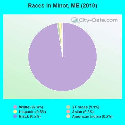
Races in Minot detailed stats: ancestries, foreign born residents, place of birth
According to our research of Maine and other state lists, there were 3 registered sex offenders living in Minot, Maine as of June 08, 2024.
The ratio of all residents to sex offenders in Minot is 869 to 1.
The ratio of registered sex offenders to all residents in this city is lower than the state average.
 Recent articles from our blog. Our writers, many of them Ph.D. graduates or candidates, create easy-to-read articles on a wide variety of topics.

 | Influx of Refugees Into Maine (79 replies) |
| Coastal towns - what am I missing? (15 replies) |
| Bears?! (52 replies) |
| Norway Area Housing (4 replies) |
| Over-the-air reception in Auburn (6 replies) |
| Fighter Jets (24 replies) |
Latest news from Minot, ME collected exclusively by city-data.com from local newspapers, TV, and radio stations
Ancestries: English (23.2%), French (22.5%), French Canadian (15.8%), Irish (12.7%), United States (9.6%), German (5.9%).
Current Local Time: EST time zone
Incorporated on 02/18/1802
Elevation: 2631 feet
Land area: 29.8 square miles.
Population density: 88 people per square mile (very low).
28 residents are foreign born
| This town: | 1.2% |
| Maine: | 2.9% |
| Minot town: | 1.8% ($1,736) |
| Maine: | 1.5% ($1,417) |
Nearest city with pop. 50,000+: Portland, ME  (32.7 miles , pop. 64,249).
Nearest city with pop. 200,000+: Boston, MA (131.2 miles , pop. 589,141).
Nearest city with pop. 1,000,000+: Bronx, NY (290.5 miles , pop. 1,332,650).
Nearest cities:
), ), )Latitude: 44.14 N, Longitude: 70.33 W
Area code commonly used in this area: 207

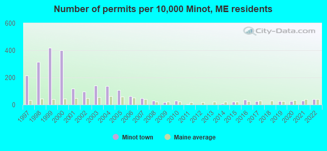
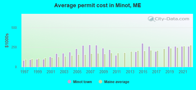
Single-family new house construction building permits:
- 2022: 9 buildings, average cost: $262,400
- 2021: 7 buildings, average cost: $262,400
- 2020: 6 buildings, average cost: $262,400
- 2019: 6 buildings, average cost: $262,400
- 2017: 6 buildings, average cost: $200,000
- 2016: 8 buildings, average cost: $264,000
- 2015: 5 buildings, average cost: $300,000
- 2014: 2 buildings, average cost: $195,000
- 2011: 1 building, cost: $150,000
- 2010: 7 buildings, average cost: $222,600
- 2009: 4 buildings, average cost: $241,900
- 2008: 7 buildings, average cost: $278,600
- 2007: 11 buildings, average cost: $284,000
- 2006: 14 buildings, average cost: $276,100
- 2005: 24 buildings, average cost: $233,500
- 2004: 31 buildings, average cost: $192,400
- 2003: 32 buildings, average cost: $174,900
- 2002: 22 buildings, average cost: $170,600
- 2001: 27 buildings, average cost: $130,300
- 2000: 90 buildings, average cost: $97,600
- 1999: 94 buildings, average cost: $97,900
- 1998: 71 buildings, average cost: $95,600
- 1997: 48 buildings, average cost: $84,200
| Here: | 2.9% |
| Maine: | 3.4% |


- Health care (9.2%)
- Educational services (8.2%)
- Construction (7.7%)
- Accommodation & food services (5.0%)
- Finance & insurance (4.4%)
- Food & beverage stores (4.1%)
- Professional, scientific, technical services (3.9%)

- Construction (13.6%)
- Educational services (5.5%)
- Repair & maintenance (4.6%)
- Food & beverage stores (4.3%)
- Transportation equipment (4.3%)
- Administrative & support & waste management services (3.8%)
- Agriculture, forestry, fishing & hunting (3.2%)

- Health care (17.2%)
- Educational services (11.3%)
- Accommodation & food services (7.3%)
- Finance & insurance (6.6%)
- Department & other general merchandise stores (6.1%)
- Professional, scientific, technical services (5.9%)
- Social assistance (5.2%)

- Other sales and related occupations, including supervisors (6.5%)
- Other management occupations, except farmers and farm managers (4.5%)
- Other production occupations, including supervisors (3.7%)
- Electrical equipment mechanics and other installation, maintenance, and repair workers, including supervisors (3.4%)
- Material recording, scheduling, dispatching, and distributing workers (3.2%)
- Driver/sales workers and truck drivers (3.2%)
- Bookkeeping, accounting, and auditing clerks (2.8%)

- Other sales and related occupations, including supervisors (7.6%)
- Driver/sales workers and truck drivers (6.1%)
- Electrical equipment mechanics and other installation, maintenance, and repair workers, including supervisors (6.1%)
- Other management occupations, except farmers and farm managers (4.7%)
- Metal workers and plastic workers (4.6%)
- Material recording, scheduling, dispatching, and distributing workers (4.4%)
- Vehicle and mobile equipment mechanics, installers, and repairers (4.3%)

- Bookkeeping, accounting, and auditing clerks (5.4%)
- Secretaries and administrative assistants (5.2%)
- Other sales and related occupations, including supervisors (5.2%)
- Registered nurses (4.7%)
- Other office and administrative support workers, including supervisors (4.4%)
- Customer service representatives (4.4%)
- Other management occupations, except farmers and farm managers (4.2%)
Average climate in Minot, Maine
Based on data reported by over 4,000 weather stations


(lower is better)

Air Quality Index (AQI) level in 2023 was 60.6. This is about average.
| City: | 60.6 |
| U.S.: | 72.6 |
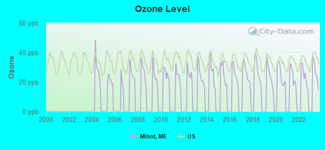
Ozone [ppb] level in 2023 was 27.1. This is better than average. Closest monitor was 15.2 miles away from the city center.
| City: | 27.1 |
| U.S.: | 33.3 |
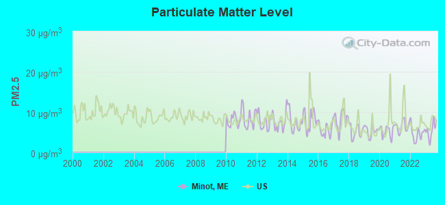
Particulate Matter (PM2.5) [µg/m3] level in 2023 was 5.52. This is significantly better than average. Closest monitor was 6.6 miles away from the city center.
| City: | 5.52 |
| U.S.: | 8.11 |
Earthquake activity:
Minot-area historical earthquake activity is significantly above Maine state average. It is 75% smaller than the overall U.S. average.On 4/20/2002 at 10:50:47, a magnitude 5.3 (5.3 ML, Depth: 3.0 mi, Class: Moderate, Intensity: VI - VII) earthquake occurred 168.6 miles away from the city center
On 10/16/2012 at 23:12:25, a magnitude 4.7 (4.7 ML, Depth: 10.0 mi, Class: Light, Intensity: IV - V) earthquake occurred 40.7 miles away from the city center
On 4/20/2002 at 10:50:47, a magnitude 5.2 (5.2 MB, 4.2 MS, 5.2 MW, 5.0 MW) earthquake occurred 169.4 miles away from Minot center
On 10/7/1983 at 10:18:46, a magnitude 5.3 (5.1 MB, 5.3 LG, 5.1 ML) earthquake occurred 199.8 miles away from Minot center
On 1/19/1982 at 00:14:42, a magnitude 4.7 (4.5 MB, 4.7 MD, 4.5 LG) earthquake occurred 77.1 miles away from the city center
On 2/26/1999 at 03:38:43, a magnitude 3.8 (3.8 LG, Depth: 2.0 mi, Class: Light, Intensity: II - III) earthquake occurred 46.6 miles away from the city center
Magnitude types: regional Lg-wave magnitude (LG), body-wave magnitude (MB), duration magnitude (MD), local magnitude (ML), surface-wave magnitude (MS), moment magnitude (MW)
Natural disasters:
The number of natural disasters in Androscoggin County (28) is a lot greater than the US average (15).Major Disasters (Presidential) Declared: 21
Emergencies Declared: 7
Causes of natural disasters: Floods: 17, Storms: 12, Snows: 7, Winter Storms: 4, Hurricanes: 3, Heavy Rains: 2, Blizzard: 1, Ice Storm: 1, Mudslide: 1, Snowfall: 1, Snowstorm: 1, Tornado: 1, Wind: 1, Other: 2 (Note: some incidents may be assigned to more than one category).
Hospitals and medical centers near Minot:
- ANDROSCOGGIN KIDNEY CENTER (Dialysis Facility, about 5 miles away; AUBURN, ME)
- GOOD SHEPHERD HEALTH CARE - AUBURN (Nursing Home, about 6 miles away; AUBURN, ME)
- AUBURN NURSING HOME (Nursing Home, about 6 miles away; AUBURN, ME)
- LOVELETT HEALTH CARE CENTER (Nursing Home, about 6 miles away; AUBURN, ME)
- PROMENADE HEALTH CARE FACILITY (Nursing Home, about 6 miles away; AUBURN, ME)
- CLOVER HOME HEALTH, INC (Home Health Center, about 6 miles away; AUBURN, ME)
- CLOVER MANOR (Nursing Home, about 6 miles away; AUBURN, ME)
Colleges/universities with over 2000 students nearest to Minot:
- Saint Joseph's College of Maine (about 23 miles; Standish, ME; Full-time enrollment: 2,010)
- University of Maine at Augusta (about 30 miles; Augusta, ME; FT enrollment: 3,204)
- University of Southern Maine (about 33 miles; Portland, ME; FT enrollment: 6,647)
- Southern Maine Community College (about 35 miles; South Portland, ME; FT enrollment: 4,666)
- University of Maine at Farmington (about 38 miles; Farmington, ME; FT enrollment: 2,036)
- University of New England (about 47 miles; Biddeford, ME; FT enrollment: 4,539)
- Plymouth State University (about 73 miles; Plymouth, NH; FT enrollment: 4,838)
Public elementary/middle school in Minot:
- MINOT CONSOLIDATED SCHOOL (Location: 23 SHAW HILL ROAD, Grades: PK-6)
Points of interest:
Notable locations in Minot: West Minot Village Fire Department (A), Minot Fire Department (B), Minot Fire Department - Death Valley Substation (C). Display/hide their locations on the map
Cemeteries: Deane Cemetery (1), Bucknam Cemetery (2), Atkinson Cemetery (3), Center Hill Cemetery (4), Woodman Cemetery (5), Scott Cemetery (6), Riverside Cemetery (7). Display/hide their locations on the map
Lake: Hawkes Pond (A). Display/hide its location on the map
Streams, rivers, and creeks: Indian Brook (A), Gardner Brook (B), Morgan Brook (C), Cool Brook (D), Bog Brook (E). Display/hide their locations on the map
Birthplace of: Samuel G. Hilborn - Politician.
Drinking water stations with addresses in Minot and their reported violations in the past:
TOWN OF MINOT (Population served: 330, Groundwater):Past health violations:Past monitoring violations:
- MCL, Average - Between OCT-2008 and DEC-2008, Contaminant: Arsenic. Follow-up actions: St Public Notif requested (JAN-22-2009), St Formal NOV issued (JAN-22-2009), St Public Notif received (FEB-03-2009), St Compliance achieved (FEB-12-2009)
- MCL, Average - Between JUL-2008 and SEP-2008, Contaminant: Arsenic. Follow-up actions: St Public Notif requested (NOV-19-2008), St Formal NOV issued (NOV-19-2008), St Compliance achieved (FEB-12-2009), St Intentional no-action (SEP-15-2011)
- MCL, Average - Between APR-2008 and JUN-2008, Contaminant: Arsenic. Follow-up actions: St Public Notif requested (JUL-09-2008), St Formal NOV issued (JUL-09-2008), St Public Notif received (SEP-04-2008), St Compliance achieved (FEB-12-2009)
- MCL, Average - Between JAN-2008 and MAR-2008, Contaminant: Arsenic. Follow-up actions: St Public Notif requested (FEB-12-2008), St Formal NOV issued (FEB-12-2008), St Public Notif received (MAY-22-2008), St Compliance achieved (FEB-12-2009)
- MCL, Average - Between OCT-2007 and DEC-2007, Contaminant: Arsenic. Follow-up actions: St Public Notif requested (FEB-14-2008), St Formal NOV issued (FEB-14-2008), St Public Notif received (FEB-26-2008), St Compliance achieved (FEB-12-2009)
- MCL, Single Sample - Between JAN-2007 and DEC-2007, Contaminant: Combined Uranium. Follow-up actions: St Violation/Reminder Notice (MAR-28-2007), St Compliance achieved (FEB-12-2009)
- MCL, Monthly (TCR) - In NOV-2005, Contaminant: Coliform. Follow-up actions: St Public Notif requested (NOV-28-2005), St Violation/Reminder Notice (NOV-28-2005), St Public Notif received (2 times from JAN-12-2006 to JAN-12-2006), St Compliance achieved (JAN-12-2006)
- 4 routine major monitoring violations
- One regular monitoring violation
| This town: | 2.6 people |
| Maine: | 2.3 people |
| This town: | 75.6% |
| Whole state: | 62.9% |
| This town: | 9.3% |
| Whole state: | 9.4% |
Likely homosexual households (counted as self-reported same-sex unmarried-partner households)
- Lesbian couples: 0.6% of all households
- Gay men: 0.2% of all households
| This town: | 6.1% |
| Whole state: | 10.9% |
| This town: | 3.1% |
| Whole state: | 4.1% |
9 people in homes for the mentally retarded in 2000
For population 15 years and over in Minot:
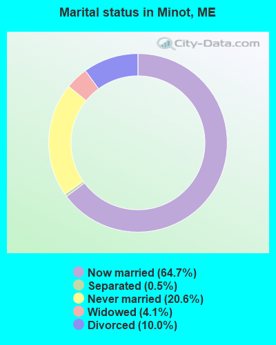
- Never married: 20.6%
- Now married: 64.7%
- Separated: 0.5%
- Widowed: 4.1%
- Divorced: 10.0%
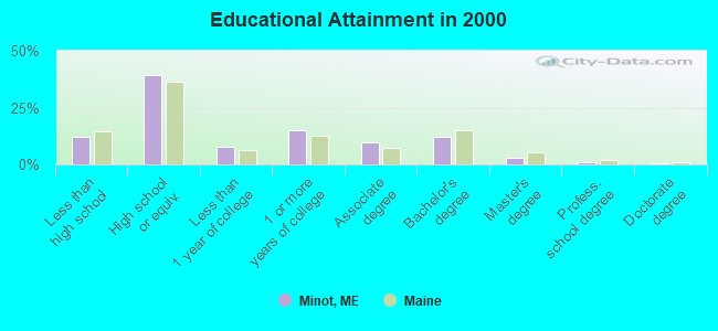
For population 25 years and over in Minot:
- High school or higher: 87.9%
- Bachelor's degree or higher: 16.2%
- Graduate or professional degree: 4.2%
- Unemployed: 3.7%
- Mean travel time to work (commute): 26.7 minutes

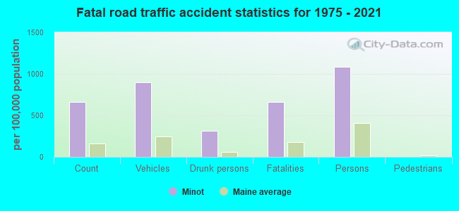
| Here: | 9.6 |
| Maine average: | 11.2 |

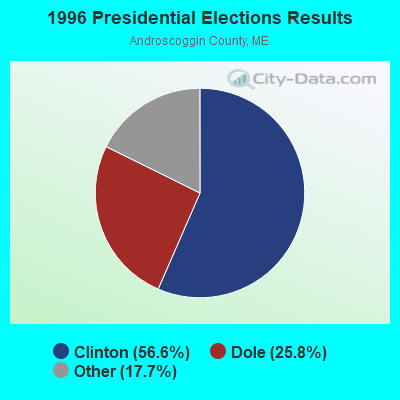
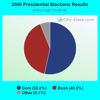


Graphs represent county-level data. Detailed 2008 Election Results
Religion statistics for Minot, ME (based on Androscoggin County data)
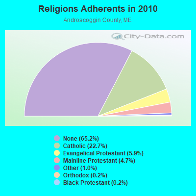
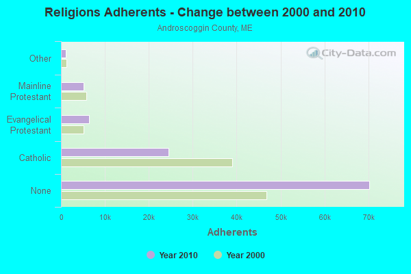
| Religion | Adherents | Congregations |
|---|---|---|
| Catholic | 24,480 | 6 |
| Evangelical Protestant | 6,383 | 37 |
| Mainline Protestant | 5,082 | 27 |
| Other | 1,097 | 8 |
| Orthodox | 225 | 1 |
| Black Protestant | 182 | 1 |
| None | 70,253 | - |
Food Environment Statistics:
| Androscoggin County: | 1.69 / 10,000 pop. |
| Maine: | 2.80 / 10,000 pop. |
| Here: | 0.19 / 10,000 pop. |
| Maine: | 0.14 / 10,000 pop. |
| This county: | 1.97 / 10,000 pop. |
| Maine: | 2.20 / 10,000 pop. |
| Here: | 5.90 / 10,000 pop. |
| State: | 5.75 / 10,000 pop. |
| Here: | 7.87 / 10,000 pop. |
| Maine: | 11.02 / 10,000 pop. |
| Androscoggin County: | 8.0% |
| State: | 8.2% |
| Androscoggin County: | 27.9% |
| Maine: | 25.0% |
Strongest AM radio stations in Minot:
- WLAM (1470 AM; 5 kW; LEWISTON, ME; Owner: RADIO PARTNERS OF MAINE, L.P.)
- WCNM (1240 AM; 1 kW; LEWISTON, ME; Owner: CHRISTIAN FAMILY RADIO, INC.)
- WTME (780 AM; 10 kW; RUMFORD, ME; Owner: MOUNTAIN VALLEY BROADCASTING, INC.)
- WMTW (870 AM; 10 kW; GORHAM, ME; Owner: RADIO PARTNERS OF MAINE, L.P.)
- WGAN (560 AM; 5 kW; PORTLAND, ME; Owner: SAGA COMMUNICATIONS OF NEW ENGLAND, LLC)
- WFAU (1280 AM; 5 kW; GARDINER, ME; Owner: CAPSTAR TX LIMITED PARTNERSHIP)
- WKTQ (1450 AM; 1 kW; SOUTH PARIS, ME; Owner: PENNESSEEWASSEE BROADCASTING CO INC.)
- WRKO (680 AM; 50 kW; BOSTON, MA; Owner: ENTERCOM BOSTON LICENSE, LLC)
- WLOB (1310 AM; 5 kW; PORTLAND, ME; Owner: ATLANTIC COAST RADIO, LLC)
- WZAN (970 AM; 5 kW; PORTLAND, ME; Owner: SAGA COMMUNICATIONS OF NEW ENGLAND, LLC)
- WJAE (1440 AM; 5 kW; WESTBROOK, ME; Owner: ALTANTIC COAST RADIO, LLC)
- WSKW (1160 AM; 10 kW; SKOWHEGAN, ME; Owner: MOUNTAIN WIRELESS, INCORPORATED)
- WEEI (850 AM; 50 kW; BOSTON, MA; Owner: ENTERCOM BOSTON LICENSE, LLC)
Strongest FM radio stations in Minot:
- WBLM (102.9 FM; PORTLAND, ME; Owner: CITADEL BROADCASTING COMPANY)
- WTHT (107.5 FM; LEWISTON, ME; Owner: RADIO PARTNERS OF MAINE, L.P.)
- WMEA (90.1 FM; PORTLAND, ME; Owner: MAINE PUBLIC BROADCASTING CORPORATION)
- WPKQ (103.7 FM; NORTH CONWAY, NH; Owner: CITADEL BROADCASTING COMPANY)
- WMEK-FM (99.9 FM; AUBURN, ME; Owner: RADIO PARTNERS OF MAINE, L.P.)
- WHOM (94.9 FM; MT. WASHINGTON, NH; Owner: CITADEL BROADCASTING COMPANY)
- WJBQ (97.9 FM; PORTLAND, ME; Owner: CITADEL BROADCASTING COMPANY)
- WCYI (93.9 FM; LEWISTON, ME; Owner: CITADEL BROADCASTING COMPANY)
- WLOB-FM (96.3 FM; RUMFORD, ME; Owner: ATLANTIC COAST RADIO, LLC)
- WOXO-FM (92.7 FM; NORWAY, ME; Owner: TRI-COUNTY BROADCASTING, INC.)
- WMTW-FM (106.7 FM; NORTH WINDHAM, ME; Owner: RADIO PARTNERS OF MAINE, L.P.)
- WTBM (100.7 FM; MEXICO, ME; Owner: MOUNTAIN VALLEY BROADCASTING, INC.)
- WTOS-FM (105.1 FM; SKOWHEGAN, ME; Owner: CAPSTAR TX LIMITED PARTNERSHIP)
- WSCY (106.9 FM; MOULTONBOROUGH, NH; Owner: NORTHEAST COMMUNICATIONS CORPORATION)
- WBCI (105.9 FM; BATH, ME; Owner: BLOUNT COMMUNICATIONS, INC.)
- WVFM (105.7 FM; CAMPTON, NH; Owner: DEVON BROADCASTING COMPANY, INC.)
- WCLZ (98.9 FM; BRUNSWICK, ME; Owner: CITADEL BROADCASTING COMPANY)
- WPOR (101.9 FM; PORTLAND, ME; Owner: SAGA COMMUNICATIONS OF NEW ENGLAND, LLC)
- WJJB-FM (95.5 FM; TOPSHAM, ME; Owner: ATLANTIC COAST RADIO, LLC)
- WMSJ (89.3 FM; FREEPORT, ME; Owner: DOWNEAST CHRISTIAN COMMUNICATIONS)
TV broadcast stations around Minot:
- WGME-TV (Channel 13; PORTLAND, ME; Owner: WGME LICENSEE, LLC)
- WMTW-TV (Channel 8; POLAND SPRING, ME; Owner: WMTW BROADCAST GROUP, LLC)
- WPFO (Channel 23; WATERVILLE, ME; Owner: CMCG PORTLAND LICENSE LLC)
- WCSH (Channel 6; PORTLAND, ME; Owner: PACIFIC AND SOUTHERN COMPANY, INC.)
- WCBB (Channel 10; AUGUSTA, ME; Owner: MAINE PUBLIC BROADCASTING CORP.)
- WPXT (Channel 51; PORTLAND, ME; Owner: HMW, INC.)
- WPME (Channel 35; LEWISTON, ME; Owner: KB PRIME MEDIA LLC)
- W32CA (Channel 32; PORTLAND, ME; Owner: NATIONAL MINORITY T.V., INC.)
- WMEA-TV (Channel 26; BIDDEFORD, ME; Owner: MAINE PUBLIC BROADCASTING CORP.)
- National Bridge Inventory (NBI) Statistics
- 5Number of bridges
- 26ft / 7.7mTotal length
- 8,587Total average daily traffic
- 424Total average daily truck traffic
- 12,263Total future (year 2035) average daily traffic
FCC Registered Antenna Towers:
13 (See the full list of FCC Registered Antenna Towers in Minot)FCC Registered Broadcast Land Mobile Towers:
4- 389 Woodman Hill Road Rte 119 (Lat: 44.111111 Lon: -70.329444), Type: Bant, Structure height: 10.4 m, Overall height: 13.4 m, Call Sign: WNAJ922,
Assigned Frequencies: 154.265 MHz, 154.310 MHz, Grant Date: 10/06/2023, Expiration Date: 01/01/2034, Registrant: County Of Androscoggin, 2 College Street, Lewiston, ME 04240-7101, Phone: (207) 784-0147, Fax: (207) 795-8938, Email:
- Pottle Hill Rd 3.2 Mi Off Rte 119 (Lat: 44.118972 Lon: -70.367556), Call Sign: WNAJ924, Licensee ID: L00809500,
Assigned Frequencies: 154.265 MHz, 154.310 MHz, Grant Date: 06/21/2000, Expiration Date: 10/23/2004, Cancellation Date: 10/07/2004, Registrant: Androscoggin County Of Maine, Eoc 2 College Street, Lewiston, ME 04240-7101, Phone: (207) 784-0147, Fax: (207) 784-0149, Email:
- EOC CENTRAL FIRE STA, 389 Woodman Hill Road Rte 119 (Lat: 44.111111 Lon: -70.329444), Type: Pipe, Structure height: 10.4 m, Overall height: 13.4 m, Call Sign: KNIQ360,
Assigned Frequencies: 154.115 MHz, Grant Date: 05/25/2023, Expiration Date: 06/01/2033, Registrant: County Of Androscoggin, 2 College Street, Lewiston, ME 04240-7101, Phone: (207) 784-0147, Fax: (207) 795-8938, Email:
- Lat: 44.125083 Lon: -70.315306, Call Sign: WQDL886,
Assigned Frequencies: 72.1400 MHz, Grant Date: 09/27/2005, Expiration Date: 09/27/2015, Cancellation Date: 11/28/2015, Certifier: Margaret Pitts, Registrant: Primex Wireless, 965 Wells Street, Lake Geneva, WI 53147, Phone: (262) 249-2344
FCC Registered Microwave Towers:
1- West Minot, 140 Harris Rd (Lat: 44.164028 Lon: -70.342861), Type: Ltower, Structure height: 36.6 m, Overall height: 39 m, Call Sign: WQRC634,
Assigned Frequencies: 11345.0 MHz, 11345.0 MHz, 11345.0 MHz, 11345.0 MHz, 11345.0 MHz, 11345.0 MHz, 11345.0 MHz, 11345.0 MHz, 11345.0 MHz, 17915.0 MHz... (+8 more), Grant Date: 04/16/2013, Expiration Date: 04/16/2023, Cancellation Date: 09/17/2020, Certifier: Jessica B Lyons, Registrant: At&t Services, Inc., 208 S. Akard Street, Room 2100, Dallas, TX 75202, Phone: (855) 699-7073, Email:
FCC Registered Amateur Radio Licenses:
15 (See the full list of FCC Registered Amateur Radio Licenses in Minot)FAA Registered Aircraft:
7- Aircraft: RANS INC RANS S-7LS (Category: Land, Seats: 2, Weight: Up to 12,499 Pounds), Engine: ROTAX SEE BOMBADIER (4 Cycle)
N-Number: 144NS, N144NS, N-144NS, Serial Number: 0705408, Year manufactured: 2006, Airworthiness Date: 03/23/2006, Certificate Issue Date: 06/05/2006
Registrant (Individual): Paul Sasseville, Po Box 152, Minot, ME 04258 - Aircraft: YOULAND DAVID R/YOULAND KURT R PA-18 REPLICA (Category: Amphibian, Seats: 2, Weight: Up to 12,499 Pounds), Engine: LYCOMING O-320-E2A (150 HP) (Reciprocating)
N-Number: 150JP, N150JP, N-150JP, Serial Number: 001, Year manufactured: 2010, Airworthiness Date: 02/18/2010, Certificate Issue Date: 06/06/2019
Registrant (Individual): Jill M Piper, 318 Holbrook Rd, Minot, ME 04258
Deregistered: Cancel Date: 05/15/2012, Exported to: Germany - Aircraft: PABLO BARROZO RI 162F (Category: Land, Seats: 2, Weight: Up to 12,499 Pounds), Engine: ROTORWAY RI 162F (150 HP) (4 Cycle)
N-Number: 352ZX, N352ZX, N-352ZX, Serial Number: 6368, Year manufactured: 2019, Airworthiness Date: 09/06/2019, Certificate Issue Date: 09/24/2020
Registrant (Individual): Michael N Dubuc, 60 Star Dr, Minot, ME 04258 - Aircraft: CESSNA 172S (Category: Land, Seats: 4, Weight: Up to 12,499 Pounds), Engine: LYCOMING O&VO-360 SER (180 HP) (Reciprocating)
N-Number: 598SP, N598SP, N-598SP, Serial Number: 172S8526, Year manufactured: 2000, Airworthiness Date: 07/27/2000, Certificate Issue Date: 08/05/2019
Registrant (LLC): Fb Aviation LLC, 196 Marston Hill Rd, Minot, ME 04258 - Aircraft: SIXCHUTER SR7 (Category: Land, Seats: 2, Weight: Up to 12,499 Pounds), Engine: ROTAX 583 (92 HP) (2 Cycle)
N-Number: 76969, N76969, N-76969, Serial Number: 99-2184-SR7XL, Year manufactured: 1999, Airworthiness Date: 04/07/2007, Certificate Issue Date: 02/08/2007
Registrant (Individual): Michael A Theriault, 165 Millett Rd, Minot, ME 04258 - Aircraft: SCHWEIZER SGS 1-35 (Category: Land, Weight: Up to 12,499 Pounds, Speed: 105 mph), Engine: None
N-Number: 135SA, N135SA, N-135SA, Serial Number: 90, Year manufactured: 1978, Airworthiness Date: 10/26/1978, Certificate Issue Date: 06/01/2016
Registrant (Co-Owned): Jason J Piper, 318 Holbrook Rd, Minot, ME 04258, Other Owners: Peter A Stauble, Roy A Bourgeois, Peter C Eiche
Deregistered: Cancel Date: 12/17/2018 - Aircraft: CESSNA 140 (Category: Land, Seats: 2, Weight: Up to 12,499 Pounds, Speed: 105 mph), Engine: CONT MOTOR C85 SERIES (85 HP) (Reciprocating)
N-Number: 2414N, N2414N, N-2414N, Serial Number: 12663, Year manufactured: 1947, Airworthiness Date: 12/20/1955
Registrant (Individual): Reported Sale, 318 Holbrook Rd, Minot, ME 04258
Deregistered: Cancel Date: 09/07/2018
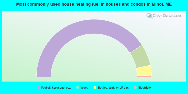
- 81.3%Fuel oil, kerosene, etc.
- 12.2%Wood
- 5.7%Bottled, tank, or LP gas
- 0.8%Electricity
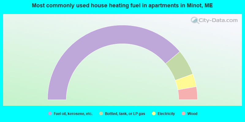
- 77.8%Fuel oil, kerosene, etc.
- 11.1%Bottled, tank, or LP gas
- 5.6%Electricity
- 5.6%Wood
Minot compared to Maine state average:
- Unemployed percentage significantly below state average.
- Black race population percentage significantly below state average.
- Hispanic race population percentage below state average.
- Foreign-born population percentage significantly below state average.
- Renting percentage significantly below state average.
- Length of stay since moving in significantly above state average.
- Number of rooms per house significantly below state average.
- House age significantly below state average.
- Percentage of population with a bachelor's degree or higher below state average.

|
|
Total of 7 patent applications in 2008-2024.