Milford, New Jersey

Milford: Bike in Springtime

Milford: Bike in Springtime

Milford: Bike in Springtime
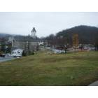
Milford: View of the town of Milford from Cemetary Hill
- add
your
Submit your own pictures of this borough and show them to the world
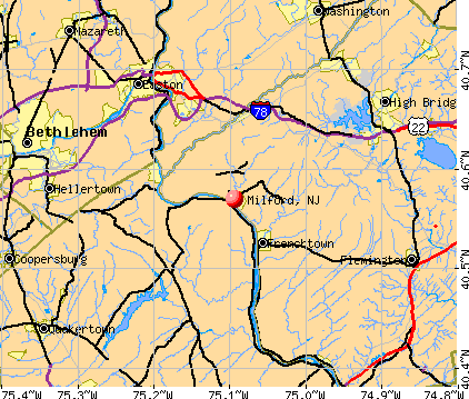
- OSM Map
- General Map
- Google Map
- MSN Map
Population change since 2000: +1.9%
 |
| Males: 583 | |
| Females: 635 |
| Median resident age: | 48.8 years |
| New Jersey median age: | 40.4 years |
Zip codes: 08848.
| Milford: | $95,197 |
| NJ: | $96,346 |
Estimated per capita income in 2022: $49,406 (it was $25,039 in 2000)
Milford borough income, earnings, and wages data
Estimated median house or condo value in 2022: $283,545 (it was $152,200 in 2000)
| Milford: | $283,545 |
| NJ: | $428,900 |
Mean prices in 2022: all housing units: $519,414; detached houses: $544,766; townhouses or other attached units: $427,886; in 2-unit structures: $378,121; in 3-to-4-unit structures: $339,996; in 5-or-more-unit structures: $247,029; mobile homes: $41,970
Median gross rent in 2022: $1,476.
(5.4% for White Non-Hispanic residents, 1.6% for Hispanic or Latino residents, 100.0% for American Indian residents, 7.0% for two or more races residents)
Detailed information about poverty and poor residents in Milford, NJ


- 1,11188.9%White alone
- 705.6%Hispanic
- 241.9%Black alone
- 131.0%Two or more races
- 80.6%Asian alone

Races in Milford detailed stats: ancestries, foreign born residents, place of birth
 Recent articles from our blog. Our writers, many of them Ph.D. graduates or candidates, create easy-to-read articles on a wide variety of topics.


Latest news from Milford, NJ collected exclusively by city-data.com from local newspapers, TV, and radio stations
Ancestries: Italian (15.4%), English (11.5%), German (8.6%), American (8.1%), Hungarian (8.1%), Irish (7.3%).
Current Local Time: EST time zone
Elevation: 300 feet
Land area: 1.15 square miles.
Population density: 1,058 people per square mile (low).
44 residents are foreign born (2.2% Europe, 0.6% Asia, 0.6% Latin America).
| This borough: | 3.5% |
| New Jersey: | 23.2% |
Median real estate property taxes paid for housing units with mortgages in 2022: $9,453 (3.1%)
Median real estate property taxes paid for housing units with no mortgage in 2022: $8,894 (3.6%)
Nearest city with pop. 50,000+: Bethlehem, PA  (15.3 miles , pop. 71,329).
Nearest city with pop. 200,000+: Philadelphia, PA (39.6 miles , pop. 1,517,550).
Nearest cities:
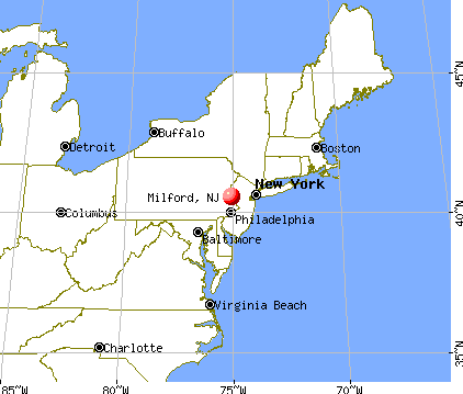
), ), ), ), )Latitude: 40.57 N, Longitude: 75.09 W
Area code: 908


| Here: | 3.5% |
| New Jersey: | 4.5% |
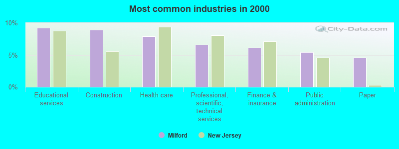
- Educational services (9.2%)
- Construction (8.9%)
- Health care (7.9%)
- Professional, scientific, technical services (6.6%)
- Finance & insurance (6.1%)
- Public administration (5.4%)
- Paper (4.6%)
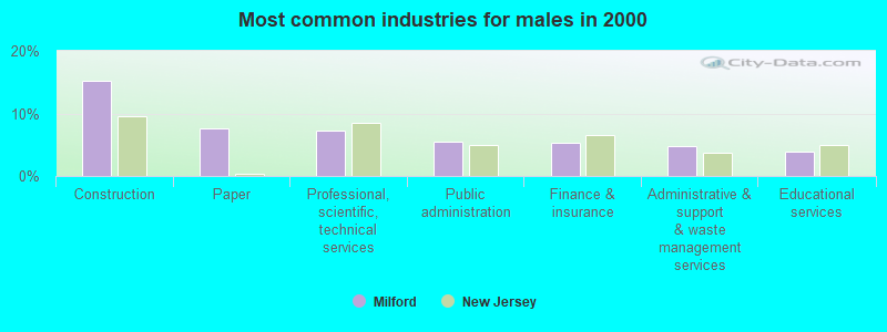
- Construction (15.2%)
- Paper (7.6%)
- Professional, scientific, technical services (7.3%)
- Public administration (5.6%)
- Finance & insurance (5.3%)
- Administrative & support & waste management services (4.7%)
- Educational services (3.8%)
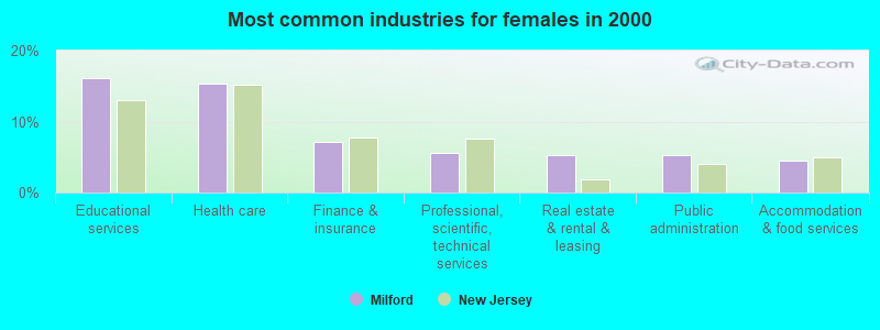
- Educational services (16.1%)
- Health care (15.4%)
- Finance & insurance (7.1%)
- Professional, scientific, technical services (5.6%)
- Real estate & rental & leasing (5.2%)
- Public administration (5.2%)
- Accommodation & food services (4.5%)

- Secretaries and administrative assistants (6.1%)
- Other production occupations, including supervisors (4.4%)
- Other office and administrative support workers, including supervisors (4.1%)
- Electrical equipment mechanics and other installation, maintenance, and repair workers, including supervisors (4.1%)
- Other sales and related occupations, including supervisors (3.9%)
- Retail sales workers, except cashiers (3.6%)
- Computer specialists (3.5%)

- Electrical equipment mechanics and other installation, maintenance, and repair workers, including supervisors (7.3%)
- Other production occupations, including supervisors (6.2%)
- Computer specialists (5.3%)
- Other office and administrative support workers, including supervisors (5.0%)
- Top executives (4.7%)
- Driver/sales workers and truck drivers (4.1%)
- Construction laborers (3.2%)

- Secretaries and administrative assistants (13.1%)
- Other sales and related occupations, including supervisors (7.1%)
- Financial clerks, except bookkeeping, accounting and auditing clerks (5.6%)
- Retail sales workers, except cashiers (5.6%)
- Preschool, kindergarten, elementary, and middle school teachers (4.9%)
- Registered nurses (4.9%)
- Information and record clerks, except customer service representatives (4.1%)
Average climate in Milford, New Jersey
Based on data reported by over 4,000 weather stations


(lower is better)

Air Quality Index (AQI) level in 2023 was 107. This is significantly worse than average.
| City: | 107 |
| U.S.: | 73 |

Carbon Monoxide (CO) [ppm] level in 2013 was 0.0642. This is significantly better than average. Closest monitor was 9.2 miles away from the city center.
| City: | 0.0642 |
| U.S.: | 0.2513 |

Nitrogen Dioxide (NO2) [ppb] level in 2023 was 8.45. This is significantly worse than average. Closest monitor was 9.2 miles away from the city center.
| City: | 8.45 |
| U.S.: | 5.11 |

Sulfur Dioxide (SO2) [ppb] level in 2023 was 0.696. This is significantly better than average. Closest monitor was 9.2 miles away from the city center.
| City: | 0.696 |
| U.S.: | 1.515 |

Ozone [ppb] level in 2023 was 30.8. This is about average. Closest monitor was 11.3 miles away from the city center.
| City: | 30.8 |
| U.S.: | 33.3 |

Particulate Matter (PM10) [µg/m3] level in 2022 was 13.0. This is significantly better than average. Closest monitor was 13.6 miles away from the city center.
| City: | 13.0 |
| U.S.: | 19.2 |

Particulate Matter (PM2.5) [µg/m3] level in 2023 was 13.4. This is significantly worse than average. Closest monitor was 10.1 miles away from the city center.
| City: | 13.4 |
| U.S.: | 8.1 |
Tornado activity:
Milford-area historical tornado activity is slightly above New Jersey state average. It is 7% smaller than the overall U.S. average.
On 10/18/1990, a category F3 (max. wind speeds 158-206 mph) tornado 18.1 miles away from the Milford borough center injured 8 people and caused between $500,000 and $5,000,000 in damages.
On 7/26/1981, a category F3 tornado 27.4 miles away from the borough center injured 2 people and caused between $50,000 and $500,000 in damages.
Earthquake activity:
Milford-area historical earthquake activity is significantly above New Jersey state average. It is 67% smaller than the overall U.S. average.On 8/23/2011 at 17:51:04, a magnitude 5.8 (5.8 MW, Depth: 3.7 mi, Class: Moderate, Intensity: VI - VII) earthquake occurred 238.8 miles away from Milford center
On 1/16/1994 at 01:49:16, a magnitude 4.6 (4.6 MB, 4.6 LG, Depth: 3.1 mi, Class: Light, Intensity: IV - V) earthquake occurred 52.3 miles away from the city center
On 10/7/1983 at 10:18:46, a magnitude 5.3 (5.1 MB, 5.3 LG, 5.1 ML) earthquake occurred 237.2 miles away from Milford center
On 1/16/1994 at 00:42:43, a magnitude 4.2 (4.2 MB, 4.0 LG, Depth: 3.1 mi) earthquake occurred 50.9 miles away from Milford center
On 4/20/2002 at 10:50:47, a magnitude 5.3 (5.3 ML, Depth: 3.0 mi) earthquake occurred 281.8 miles away from the city center
On 4/20/2002 at 10:50:47, a magnitude 5.2 (5.2 MB, 4.2 MS, 5.2 MW, 5.0 MW) earthquake occurred 279.9 miles away from the city center
Magnitude types: regional Lg-wave magnitude (LG), body-wave magnitude (MB), local magnitude (ML), surface-wave magnitude (MS), moment magnitude (MW)
Natural disasters:
The number of natural disasters in Hunterdon County (23) is greater than the US average (15).Major Disasters (Presidential) Declared: 14
Emergencies Declared: 9
Causes of natural disasters: Hurricanes: 7, Floods: 4, Storms: 4, Blizzards: 2, Snowstorms: 2, Water Shortages: 2, Heavy Rain: 1, Tropical Depression: 1, Tropical Storm: 1, Winter Storm: 1, Other: 3 (Note: some incidents may be assigned to more than one category).

Hospitals and medical centers near Milford:
- VALLEY VIEW HEALTH CARE CTR (Nursing Home, about 3 miles away; FRENCHTOWN, NJ)
- COUNTRY ARCH CARE CENTER (Nursing Home, about 9 miles away; PITTSTOWN, NJ)
- PHILLIPSBURG CENTER (Nursing Home, about 9 miles away; PHILLIPSBURG, NJ)
- FMC PHILLIPSBURG DIALYSIS CTR (Dialysis Facility, about 10 miles away; PHILLIPSBURG, NJ)
- KAQ HOME CARE, INC (Home Health Center, about 10 miles away; PHILLIPSBURG, NJ)
- BRAKELEY PARK CENTER (Nursing Home, about 11 miles away; PHILLIPSBURG, NJ)
- ST LUKE'S WARREN HOSPITAL Acute Care Hospitals (about 11 miles away; PHILLIPSBURG, NJ)
Airports and other landing facilities located in Milford:
See details about Airports and other landing facilities located in Milford, NJColleges/universities with over 2000 students nearest to Milford:
- Lafayette College (about 11 miles; Easton, PA; Full-time enrollment: 2,562)
- Northampton County Area Community College (about 14 miles; Bethlehem, PA; FT enrollment: 7,195)
- DeSales University (about 15 miles; Center Valley, PA; FT enrollment: 2,862)
- Lehigh University (about 16 miles; Bethlehem, PA; FT enrollment: 6,565)
- Delaware Valley College (about 20 miles; Doylestown, PA; FT enrollment: 2,025)
- Raritan Valley Community College (about 22 miles; Branchburg, NJ; FT enrollment: 5,735)
- Muhlenberg College (about 22 miles; Allentown, PA; FT enrollment: 2,792)
Public elementary/middle schools in Milford:
- HOLLAND TOWNSHIP ELEMENTARY SCHOOL (Students: 448, Location: 714 MILFORD WARREN GLEN ROAD, Grades: PK-8)
- MILFORD SCHOOL (Students: 119, Location: 7 HILLSIDE AVENUE, Grades: PK-8)
Libraries in Milford:
- HOLLAND TOWNSHIP FREE PUBLIC LIBRARY (Operating income: $69,816; Location: 129 SPRING MILLS ROAD; 26,416 books; 1,250 audio materials; 1,928 video materials; 22 state licensed databases; 67 print serial subscriptions)
- MILFORD PUBLIC LIBRARY (Operating income: $57,050; Location: 40 FRENCHTOWN-MILFORD ROAD; 16,479 books; 718 audio materials; 417 video materials; 22 state licensed databases; 32 print serial subscriptions)
Points of interest:
Notable locations in Milford: Milford - Holland Rescue Squad (A), Milford Fire Company (B). Display/hide their locations on the map
Cemetery: Milford Union Cemetery (1). Display/hide its location on the map
Creek: Hakihokake Creek (A). Display/hide its location on the map
Tourist attraction: Education-Enrichment - Libraries (Cultural Attractions- Events- & Facilities; Frenchtown Road).
Birthplace of: George C. Ludlow - Politician.
| This borough: | 2.4 people |
| New Jersey: | 2.7 people |
| This borough: | 63.7% |
| Whole state: | 69.3% |
| This borough: | 6.9% |
| Whole state: | 5.9% |
Likely homosexual households (counted as self-reported same-sex unmarried-partner households)
- Lesbian couples: 0.0% of all households
- Gay men: 0.6% of all households
For population 15 years and over in Milford:

- Never married: 26.8%
- Now married: 57.3%
- Separated: 0.9%
- Widowed: 3.4%
- Divorced: 11.5%
For population 25 years and over in Milford:
- High school or higher: 93.5%
- Bachelor's degree or higher: 31.2%
- Graduate or professional degree: 13.4%
- Unemployed: 3.6%
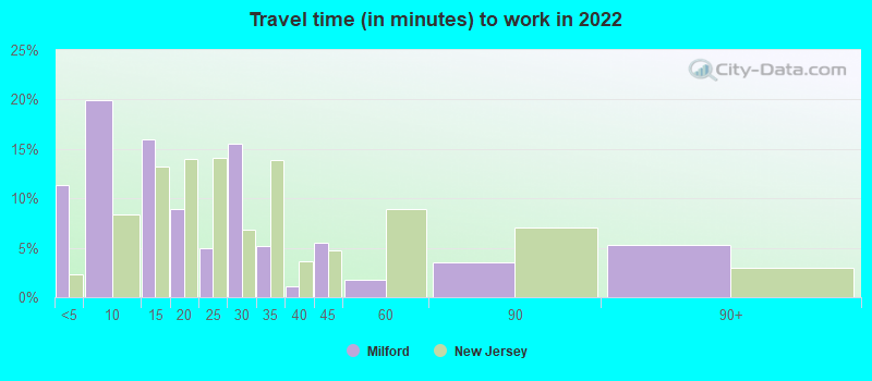
- Mean travel time to work (commute): 28.0 minutes


| Here: | 11.3 |
| New Jersey average: | 12.8 |
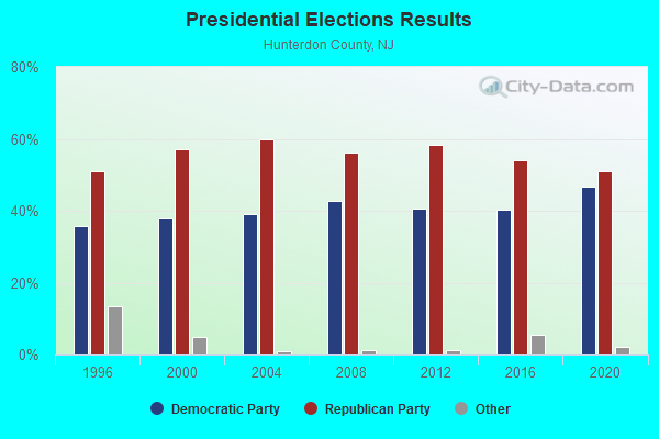
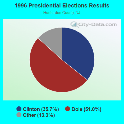
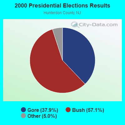
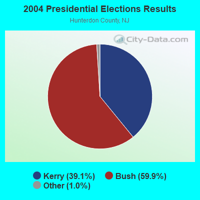
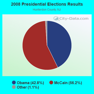


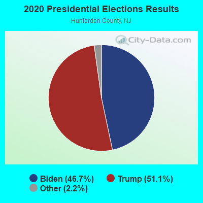
Graphs represent county-level data. Detailed 2008 Election Results
Religion statistics for Milford, NJ (based on Hunterdon County data)
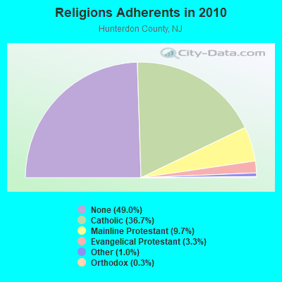
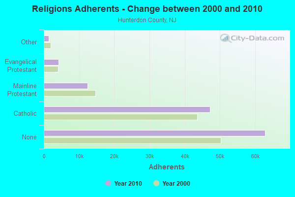
| Religion | Adherents | Congregations |
|---|---|---|
| Catholic | 47,122 | 10 |
| Mainline Protestant | 12,472 | 61 |
| Evangelical Protestant | 4,222 | 27 |
| Other | 1,336 | 11 |
| Orthodox | 362 | 2 |
| None | 62,835 | - |
Food Environment Statistics:
| This county: | 1.94 / 10,000 pop. |
| New Jersey: | 2.90 / 10,000 pop. |
| This county: | 0.08 / 10,000 pop. |
| New Jersey: | 0.06 / 10,000 pop. |
| Hunterdon County: | 1.24 / 10,000 pop. |
| New Jersey: | 1.76 / 10,000 pop. |
| Here: | 1.32 / 10,000 pop. |
| New Jersey: | 0.81 / 10,000 pop. |
| Hunterdon County: | 8.53 / 10,000 pop. |
| New Jersey: | 7.15 / 10,000 pop. |
| Hunterdon County: | 6.8% |
| State: | 8.3% |
| Here: | 18.8% |
| State: | 23.3% |
| Hunterdon County: | 17.4% |
| New Jersey: | 18.0% |
Health and Nutrition:
| Milford: | 49.7% |
| New Jersey: | 50.6% |
| This city: | 47.4% |
| New Jersey: | 48.5% |
| Here: | 29.2 |
| State: | 28.5 |
| This city: | 23.0% |
| State: | 20.0% |
| This city: | 9.7% |
| New Jersey: | 11.1% |
| Here: | 6.8 |
| New Jersey: | 6.8 |
| Here: | 38.4% |
| State: | 33.6% |
| Here: | 56.3% |
| New Jersey: | 56.9% |
| This city: | 77.6% |
| New Jersey: | 80.0% |
More about Health and Nutrition of Milford, NJ Residents
| Local government employment and payroll (March 2022) | |||||
| Function | Full-time employees | Monthly full-time payroll | Average yearly full-time wage | Part-time employees | Monthly part-time payroll |
|---|---|---|---|---|---|
| Streets and Highways | 2 | $8,702 | $52,212 | 0 | $0 |
| Sewerage | 2 | $12,573 | $75,438 | 3 | $456 |
| Other Government Administration | 1 | $6,065 | $72,780 | 8 | $382 |
| Local Libraries | 1 | $5,531 | $66,372 | 3 | $708 |
| Water Supply | 1 | $5,445 | $65,340 | 0 | $0 |
| Firefighters | 0 | $0 | 1 | $152 | |
| Judicial and Legal | 0 | $0 | 3 | $1,498 | |
| Other and Unallocable | 0 | $0 | 8 | $2,859 | |
| Police - Other | 0 | $0 | 1 | $1,566 | |
| Totals for Government | 7 | $38,316 | $65,685 | 27 | $7,621 |
Milford government finances - Expenditure in 2017 (per resident):
- Current Operations - General - Other: $223,000 ($183.09)
Regular Highways: $118,000 ($96.88)
Central Staff Services: $113,000 ($92.78)
Solid Waste Management: $95,000 ($78.00)
Local Fire Protection: $62,000 ($50.90)
Judicial and Legal Services: $60,000 ($49.26)
Libraries: $49,000 ($40.23)
Health - Other: $41,000 ($33.66)
Financial Administration: $40,000 ($32.84)
General Public Buildings: $19,000 ($15.60)
Housing and Community Development: $10,000 ($8.21)
Parks and Recreation: $2,000 ($1.64)
Police Protection: $2,000 ($1.64)
- General - Interest on Debt: $193,000 ($158.46)
- Total Salaries and Wages: $175,000 ($143.68)
Milford government finances - Revenue in 2017 (per resident):
- Miscellaneous - Interest Earnings: $3,000 ($2.46)
- State Intergovernmental - General Local Government Support: $286,000 ($234.81)
Other: $7,000 ($5.75)
- Tax - Property: $3,927,000 ($3224.14)
Alcoholic Beverage License: $6,000 ($4.93)
Milford government finances - Debt in 2017 (per resident):
- Long Term Debt - Beginning Outstanding - Unspecified Public Purpose: $4,827,000 ($3963.05)
Outstanding Unspecified Public Purpose: $4,748,000 ($3898.19)
Retired Unspecified Public Purpose: $79,000 ($64.86)
Milford government finances - Cash and Securities in 2017 (per resident):
- Other Funds - Cash and Securities: $1,881,000 ($1544.33)
Businesses in Milford, NJ
- H&R Block: 1
Strongest AM radio stations in Milford:
- WWJZ (640 AM; 50 kW; MOUNT HOLLY, NJ; Owner: ABC, INC.)
- WCHR (1040 AM; 5 kW; FLEMINGTON, NJ; Owner: NASSAU BROADCASTING II, L.L.C.)
- WZZD (990 AM; 50 kW; PHILADELPHIA, PA; Owner: PENNSYLVANIA MEDIA ASSOCIATES, INC.)
- KYW (1060 AM; 50 kW; PHILADELPHIA, PA; Owner: INFINITY BROADCASTING OPERATIONS, INC.)
- WPEN (950 AM; 50 kW; PHILADELPHIA, PA; Owner: GREATER PHILADELPHIA RADIO, INC.)
- WMCA (570 AM; 50 kW; NEW YORK, NY; Owner: SALEM MEDIA OF NEW YORK, LLC)
- WVCH (740 AM; 50 kW; CHESTER, PA; Owner: WVCH COMMUNICATIONS, INC.)
- WPHT (1210 AM; 50 kW; PHILADELPHIA, PA; Owner: INFINITY BROADCASTING OPERATIONS, INC.)
- WNWR (1540 AM; 50 kW; PHILADELPHIA, PA)
- WOR (710 AM; 50 kW; NEW YORK, NY; Owner: BUCKLEY BROADCASTING CORPORATION)
- WABC (770 AM; 50 kW; NEW YORK, NY; Owner: WABC-AM RADIO, INC.)
- WINS (1010 AM; 50 kW; NEW YORK, NY; Owner: INFINITY BROADCASTING OPERATIONS, INC.)
- WEPN (1050 AM; 50 kW; NEW YORK, NY; Owner: NEW YORK AM RADIO, LLC)
Strongest FM radio stations in Milford:
- WZZO (95.1 FM; BETHLEHEM, PA; Owner: CAPSTAR TX LIMITED PARTNERSHIP)
- W245AC (96.9 FM; HARMONY TOWNSHIP, NJ; Owner: MERCER COUNTY COMMUNITY COLLEGE)
- WLEV (100.7 FM; ALLENTOWN, PA; Owner: CITADEL BROADCASTING COMPANY)
- WCVH (90.5 FM; FLEMINGTON, NJ; Owner: HUNTERDON CENTRAL H. S. BD. OF EDUC.)
- WDIY (88.1 FM; ALLENTOWN, PA; Owner: LEHIGH VALLEY COMMUNITY BR/CST ASSOC)
- WODE-FM (99.9 FM; EASTON, PA; Owner: NASSAU BROADCASTING II, LLC)
- WJCS (89.3 FM; ALLENTOWN, PA; Owner: BEACON BROADCASTING CORPORATION)
- WWPJ (89.5 FM; PEN ARGYL, PA; Owner: MERCER COUNTY COMMUNITY COLLEGE)
- WLVR-FM (91.3 FM; BETHLEHEM, PA; Owner: LEHIGH UNIVERSITY)
- W289AA (105.7 FM; LEBANON TOWNSHIP, NJ; Owner: MERCER COUNTY COMMUNITY COLLEGE)
- W278AI (103.5 FM; CENTER VALLEY, PA; Owner: BUX-MONT EDUCATIONAL RADIO ASSOCIATION)
- W224AU (92.7 FM; ALLENTOWN, PA; Owner: MERCER COUNTY COMMUNITY COLLEGE)
- W224AS (92.7 FM; WASHINGTON, NJ; Owner: WRNJ RADIO, INC.)
- WDVR (89.7 FM; DELAWARE TOWNSHIP, NJ; Owner: PENN-JERSEY EDUCATIONAL RADIO CORP.)
- W246AA (97.1 FM; ALLENTOWN, ETC., PA; Owner: TEMPLE UNIV. OF THE COMMONWEALTH,ETC)
- WCTO (96.1 FM; EASTON, PA; Owner: CITADEL BROADCASTING COMPANY)
- W290AC (105.9 FM; PALMERTON, PA; Owner: FAMILY STATIONS, INC.)
- WKXW-FM (101.5 FM; TRENTON, NJ; Owner: MILLENNIUM CENTRAL NEW JERSEY LICENSE HOLDCO, LLC)
- WSBG (93.5 FM; STROUDSBURG, PA; Owner: NASSAU BROADCASTING II, L.L.C.)
- WAWZ (99.1 FM; ZAREPHATH, NJ; Owner: PILLAR OF FIRE)
TV broadcast stations around Milford:
- WFMZ-TV (Channel 69; ALLENTOWN, PA; Owner: MARANATHA BROADCASTING COMPANY, INC.)
- KYW-TV (Channel 3; PHILADELPHIA, PA; Owner: CBS BROADCASTING INC.)
- WLVT-TV (Channel 39; ALLENTOWN, PA; Owner: LEHIGH VALLEY PUBLIC TELECOMMUNICATIONS CORP.)
- WPHL-TV (Channel 17; PHILADELPHIA, PA; Owner: TRIBUNE TELEVISION COMPANY)
- W07DC (Channel 7; ALLENTOWN/BETHLEHEM, PA; Owner: NEW YORK TIMES MANAGEMENT SERVICES)
- WNJT (Channel 52; TRENTON, NJ; Owner: NEW JERSEY PUBLIC BROADCASTING AUTHORITY)
- WPPX (Channel 61; WILMINGTON, DE; Owner: PAXSON PHILADELPHIA LICENSE, INC.)
- WBPH-TV (Channel 60; BETHLEHEM, PA; Owner: SONSHINE FAMILY TELEVISION CORPORATION)
- WPVI-TV (Channel 6; PHILADELPHIA, PA; Owner: ABC, INC.)
- WPSG (Channel 57; PHILADELPHIA, PA; Owner: VIACOM STATIONS GROUP OF PHILADELPHIA INC.)
- WCAU (Channel 10; PHILADELPHIA, PA; Owner: NBC SUBSIDIARY (WCAU-TV), L.P.)
- WGTW (Channel 48; BURLINGTON, NJ; Owner: BRUNSON COMMUNICATIONS, INC.)
- WYBE (Channel 35; PHILADELPHIA, PA; Owner: INDEPENDENCE PUBLIC MEDIA OF PHILADELPHIA, INC.)
- WELL-LP (Channel 8; WILLOW GROVE, ETC., PA; Owner: WORD OF GOD FELLOWSHIP, INC.)
- WHYY-TV (Channel 12; WILMINGTON, DE; Owner: WHYY, INC.)
- WTXF-TV (Channel 29; PHILADELPHIA, PA; Owner: FOX TV STATIONS OF PHILADELPHIA)
- W25BB (Channel 25; PITTSTOWN, NJ; Owner: NEW JERSEY PUBLIC B/CASTNG AUTHORITY)
- WPXO-LP (Channel 34; EAST ORANGE, NJ; Owner: PAXSON COMMUNICATIONS LPTV, INC.)
- WNJN (Channel 50; MONTCLAIR, NJ; Owner: NEW JERSEY PUBLIC B/CNG AUTHORITY)
- W55BS (Channel 55; BELVIDERE, NJ; Owner: NEW JERSEY PUBLIC BROADCASTING AUTHORITY)
- W46BL (Channel 46; ALLENTOWN-BETHLEHEM, PA; Owner: MARANATHA BROADCASTING COMPANY, INC.)
Milford fatal accident list:
Sep 2, 2021 07:21 AM, Carpenter St, Lat: 40.565825, Lon: -75.093550, Vehicles: 1, Persons: 1, Fatalities: 1
Dec 11, 1986 02:47 PM, Cr619, Vehicles: 2, Persons: 2, Fatalities: 1
Jan 12, 1980 00:56 AM, Vehicles: 1, Persons: 1, Fatalities: 1
Aug 12, 1979 07:22 PM, Vehicles: 2, Persons: 3, Fatalities: 1
- National Bridge Inventory (NBI) Statistics
- 17Number of bridges
- 128ft / 38.8mTotal length
- $2,384,000Total costs
- 28,180Total average daily traffic
- 938Total average daily truck traffic
- 34,055Total future (year 2040) average daily traffic

- New bridges - historical statistics
- 41900-1909
- 11930-1939
- 21940-1949
- 11950-1959
- 31980-1989
- 11990-1999
- 42000-2009
- 12010-2019
FCC Registered Antenna Towers:
28 (See the full list of FCC Registered Antenna Towers in Milford)FCC Registered Broadcast Land Mobile Towers:
7- Dirt Lane Off Church Rd (Lat: 40.589806 Lon: -75.141833), Type: Tower, Structure height: 18 m, Overall height: 37 m, Call Sign: KJK695,
Assigned Frequencies: 155.865 MHz, Grant Date: 02/09/2021, Expiration Date: 02/20/2031, Registrant: Industrial Communications Company, 121 N Sitgreaves St, Easton, PA 18042-3697, Phone: (610) 253-1214, Fax: (610) 253-4504, Email:
- Lat: 40.582611 Lon: -75.191278, Call Sign: WPNP682,
Assigned Frequencies: 466.962 MHz, 466.412 MHz, 466.712 MHz, Grant Date: 02/26/2024, Expiration Date: 04/23/2034, Certifier: Claressia Leaks, Registrant: Georgia-Pacific LLC, 133 Peachtree St Ne - 24th Fl, Atlanta, GA 30303, Phone: (404) 487-4134, Email:
- Gilbert Station River Rd (Lat: 40.568167 Lon: -75.162111), Call Sign: WNGR556,
Assigned Frequencies: 48.8000 MHz, 49.5000 MHz, Grant Date: 06/15/2011, Expiration Date: 08/19/2021, Cancellation Date: 10/23/2021, Registrant: Talen Energy Supply, LLC, 835 Hamilton Street, Suite 150, Allentown, PA 18101, Phone: (610) 774-4219, Fax: (610) 774-6293, Email:
- Rd 1 (Lat: 40.570389 Lon: -75.152667), Call Sign: KED381, Licensee ID: L00288741,
Assigned Frequencies: 153.425 MHz, 153.605 MHz, 153.665 MHz, Grant Date: 03/02/2000, Expiration Date: 03/14/2005, Cancellation Date: 03/06/2002, Certifier: Steven F Lux, Registrant: Felhc, Inc., 76 South Main Street, Akron, OH 44308, Phone: (330) 384-5498, Fax: (330) 761-7203
- Marshall Hill Rd 1/4 Mi E Union Vly Rd W (Lat: 41.137028 Lon: -74.345417), Type: Building, Structure height: 25 m, Call Sign: WPDE325,
Assigned Frequencies: 48.5200 MHz, 48.8800 MHz, 48.9000 MHz, Grant Date: 01/28/2015, Expiration Date: 02/06/2025, Registrant: Blooston, Mordkofsky, Dickens & Prendergast, LLP, 2120 L Street, N.W., Suite 825, Washington, DC 20037, Phone: (202) 828-5565, Fax: (202) 828-5568, Email:
- 7 Hillside Avenue (Lat: 40.568333 Lon: -75.092500), Call Sign: WQRU815,
Assigned Frequencies: 462.362 MHz, 452.087 MHz, 452.687 MHz, 452.412 MHz, Grant Date: 07/30/2013, Expiration Date: 07/30/2023, Cancellation Date: 09/30/2023, Certifier: Susan Schaffer, Registrant: National License, 12591 Brompton Road, Carmel, IN 46033, Phone: (317) 564-8018, Email:
- Lat: 40.605444 Lon: -75.109306, Call Sign: WQTZ655,
Assigned Frequencies: 456.962 MHz, 457.387 MHz, 451.487 MHz, 456.487 MHz, Grant Date: 05/13/2014, Expiration Date: 05/13/2024, Certifier: Joel Jacquemot, Registrant: Cara Enterprises Inc, Las Vegas, NV 89140-0124, Phone: (702) 838-9728, Fax: (702) 363-4607, Email:
FCC Registered Microwave Towers:
4- STATION, Holland Twp Gravel Hill Approx 1.5 Mi W Of Route 519 (Lat: 40.589806 Lon: -75.141833), Overall height: 30.5 m, Call Sign: WNTK369,
Assigned Frequencies: 2196.00 MHz, 2188.00 MHz, Grant Date: 01/23/2008, Expiration Date: 04/13/2018, Cancellation Date: 03/19/2008, Registrant: Delaware River Joint Toll Bridge Commission, 110 Wood Street, Morrisville, PA 19067, Phone: (215) 295-5061, Fax: (215) 295-3337, Email:
- HOLLAND, Gravel Hill Approx 1.5 Mi W Of Rt 519 (Lat: 40.589639 Lon: -75.140917), Type: Ltower, Structure height: 30.5 m, Call Sign: WNTT258,
Assigned Frequencies: 6735.62 MHz, 6695.00 MHz, 6695.00 MHz, 6695.00 MHz, 6695.00 MHz, 6695.00 MHz, 6695.00 MHz, 6695.00 MHz, Grant Date: 01/20/2021, Expiration Date: 03/19/2031, Registrant: County Of Hunterdon, 201 Cherryville Rd., Flemington, NJ 08822, Phone: (908) 788-1205, Email:
- FN25, 452 County Road 579 (Lat: 40.620944 Lon: -75.027111), Type: Tower, Structure height: 42.7 m, Overall height: 43.6 m, Call Sign: WQPI944,
Assigned Frequencies: 6063.80 MHz, 6093.45 MHz, Grant Date: 06/01/2012, Expiration Date: 06/01/2022, Cancellation Date: 09/16/2015, Certifier: Melvin L Van Cleave, Registrant: Cavell Mertz & Associates, Inc., 7724 Donegan Drive, Manassas, VA 20109, Phone: (703) 392-9090, Fax: (703) 392-9559, Email:
- PHPHL00233A, 118 Carpenter Street (Nj22381-A) (Lat: 40.564583 Lon: -75.092278), Type: Mtower, Structure height: 46 m, Overall height: 48.8 m, Call Sign: WSAI667,
Assigned Frequencies: 11305.0 MHz, 11305.0 MHz, 11305.0 MHz, 11305.0 MHz, 11305.0 MHz, 11305.0 MHz, 11305.0 MHz, 11305.0 MHz, 11305.0 MHz, 11305.0 MHz, 11305.0 MHz, 11305.0 MHz, Grant Date: 01/19/2024, Expiration Date: 01/19/2034, Certifier: Alison A Minea, Registrant: Dish Wireless L.L.C., 9601 S Meridan Blvd, Englewood, CO 80112, Phone: (202) 463-3709, Email:
FCC Registered Amateur Radio Licenses:
58 (See the full list of FCC Registered Amateur Radio Licenses in Milford)FAA Registered Aircraft:
21 (See the full list of FAA Registered Aircraft in Milford)| Home Mortgage Disclosure Act Aggregated Statistics For Year 2009 (Based on 1 partial tract) | ||||||||
| A) FHA, FSA/RHS & VA Home Purchase Loans | B) Conventional Home Purchase Loans | C) Refinancings | D) Home Improvement Loans | |||||
|---|---|---|---|---|---|---|---|---|
| Number | Average Value | Number | Average Value | Number | Average Value | Number | Average Value | |
| LOANS ORIGINATED | 1 | $142,260 | 1 | $453,060 | 9 | $298,593 | 1 | $81,950 |
| APPLICATIONS APPROVED, NOT ACCEPTED | 0 | $0 | 0 | $0 | 1 | $157,150 | 0 | $0 |
| APPLICATIONS DENIED | 0 | $0 | 0 | $0 | 2 | $360,935 | 0 | $0 |
| APPLICATIONS WITHDRAWN | 0 | $0 | 0 | $0 | 2 | $290,885 | 0 | $0 |
| FILES CLOSED FOR INCOMPLETENESS | 0 | $0 | 0 | $0 | 1 | $203,660 | 0 | $0 |
Detailed HMDA statistics for the following Tracts: 0106.00
| Private Mortgage Insurance Companies Aggregated Statistics For Year 2002 (Based on 1 partial tract) | ||
| A) Conventional Home Purchase Loans | ||
|---|---|---|
| Number | Average Value | |
| LOANS ORIGINATED | 1 | $115,800 |
| APPLICATIONS APPROVED, NOT ACCEPTED | 0 | $0 |
| APPLICATIONS DENIED | 0 | $0 |
| APPLICATIONS WITHDRAWN | 0 | $0 |
| FILES CLOSED FOR INCOMPLETENESS | 0 | $0 |
Detailed PMIC statistics for the following Tracts: 0106.00


2002 - 2018 National Fire Incident Reporting System (NFIRS) incidents
- Fire incident types reported to NFIRS in Milford, NJ
- 32470.4%Structure Fires
- 10723.3%Outside Fires
- 255.4%Mobile Property/Vehicle Fires
- 40.9%Other
 Based on the data from the years 2002 - 2018 the average number of fires per year is 27. The highest number of reported fire incidents - 57 took place in 2014, and the least - 0 in 2003. The data has an increasing trend.
 When looking into fire subcategories, the most reports belonged to: Structure Fires (70.4%), and Outside Fires (23.3%).
- 62.2%Fuel oil, kerosene, etc.
- 20.3%Electricity
- 9.9%Bottled, tank, or LP gas
- 4.4%Wood
- 2.2%Utility gas
- 1.0%Other fuel

- 62.5%Electricity
- 31.2%Fuel oil, kerosene, etc.
- 3.6%Other fuel
- 2.7%Utility gas
Milford compared to New Jersey state average:
- Median house value below state average.
- Unemployed percentage significantly below state average.
- Black race population percentage significantly below state average.
- Hispanic race population percentage significantly below state average.
- Foreign-born population percentage significantly below state average.

|
|
Total of 142 patent applications in 2008-2024.