Menominee, Wisconsin
Submit your own pictures of this town and show them to the world
- OSM Map
- Google Map
- MSN Map
Population change since 2000: -7.2%
 |
| Males: 2,098 | |
| Females: 2,134 |
| Median resident age: | 31.4 years |
| Wisconsin median age: | 42.6 years |
Zip codes: 54135.
| Menominee: | $60,939 |
| WI: | $70,996 |
Estimated per capita income in 2022: $24,039 (it was $10,625 in 2000)
Menominee town income, earnings, and wages data
Estimated median house or condo value in 2022: $113,946 (it was $58,000 in 2000)
| Menominee: | $113,946 |
| WI: | $252,800 |
Mean prices in 2022: all housing units: $173,510; detached houses: $171,999; mobile homes: $198,269
Detailed information about poverty and poor residents in Menominee, WI


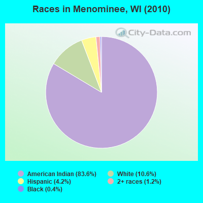
- 3,53883.6%American Indian alone
- 44710.6%White alone
- 1784.2%Hispanic
- 491.2%Two or more races
- 190.4%Black alone
- 10.02%Asian alone
Races in Menominee detailed stats: ancestries, foreign born residents, place of birth
 Recent articles from our blog. Our writers, many of them Ph.D. graduates or candidates, create easy-to-read articles on a wide variety of topics.
Ancestries: German (5.6%), English (2.4%), Irish (1.8%), French (1.5%).
Current Local Time: CST time zone
Land area: 358.0 square miles.
Population density: 12 people per square mile (very low).
121 residents are foreign born (2.0% Asia, 0.3% Europe).
| This town: | 2.7% |
| Wisconsin: | 3.6% |
| Menominee town: | 2.2% ($1,248) |
| Wisconsin: | 2.0% ($2,245) |
Nearest city with pop. 50,000+: Green Bay, WI  (42.7 miles , pop. 102,313).
Nearest city with pop. 200,000+: Madison, WI (134.1 miles , pop. 208,054).
Nearest city with pop. 1,000,000+: Chicago, IL (219.7 miles , pop. 2,896,016).
Nearest cities:
), ), ), ), ), ), ), Latitude: 44.94 N, Longitude: 88.65 W
Area code commonly used in this area: 715
| Here: | 4.2% |
| Wisconsin: | 2.7% |
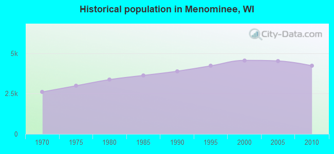
Population change in the 1990s: +474 (+11.6%).
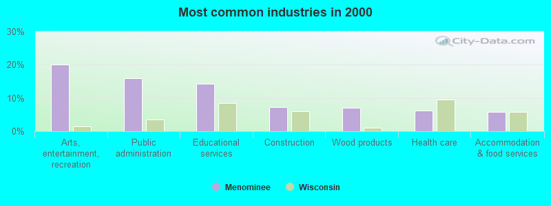
- Arts, entertainment, recreation (20.1%)
- Public administration (15.9%)
- Educational services (14.3%)
- Construction (7.3%)
- Wood products (7.1%)
- Health care (6.3%)
- Accommodation & food services (5.7%)
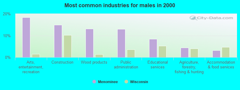
- Arts, entertainment, recreation (18.3%)
- Construction (14.8%)
- Wood products (13.1%)
- Public administration (13.0%)
- Educational services (8.4%)
- Agriculture, forestry, fishing & hunting (4.4%)
- Accommodation & food services (3.2%)
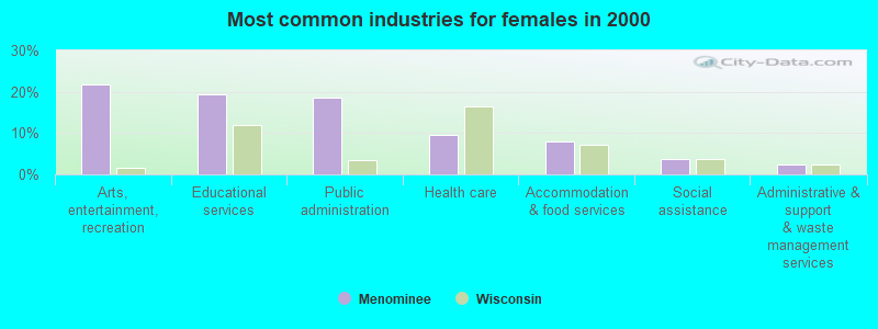
- Arts, entertainment, recreation (21.6%)
- Educational services (19.4%)
- Public administration (18.5%)
- Health care (9.7%)
- Accommodation & food services (7.8%)
- Social assistance (3.7%)
- Administrative & support & waste management services (2.5%)
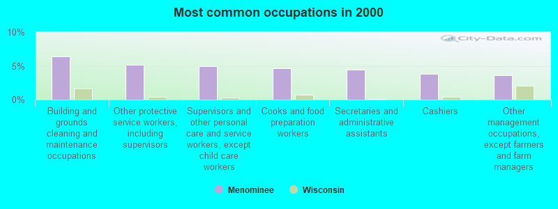
- Building and grounds cleaning and maintenance occupations (6.4%)
- Other protective service workers, including supervisors (5.2%)
- Supervisors and other personal care and service workers, except child care workers (4.9%)
- Cooks and food preparation workers (4.6%)
- Secretaries and administrative assistants (4.4%)
- Cashiers (3.8%)
- Other management occupations, except farmers and farm managers (3.6%)
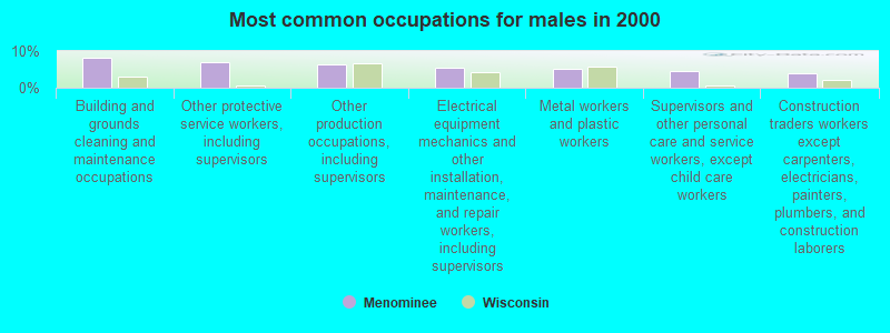
- Building and grounds cleaning and maintenance occupations (8.1%)
- Other protective service workers, including supervisors (6.9%)
- Other production occupations, including supervisors (6.4%)
- Electrical equipment mechanics and other installation, maintenance, and repair workers, including supervisors (5.4%)
- Metal workers and plastic workers (5.2%)
- Supervisors and other personal care and service workers, except child care workers (4.6%)
- Construction traders workers except carpenters, electricians, painters, plumbers, and construction laborers (4.0%)
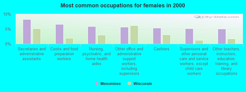
- Secretaries and administrative assistants (8.2%)
- Cooks and food preparation workers (6.6%)
- Nursing, psychiatric, and home health aides (5.8%)
- Other office and administrative support workers, including supervisors (5.7%)
- Cashiers (5.3%)
- Supervisors and other personal care and service workers, except child care workers (5.2%)
- Other teachers, instructors, education, training, and library occupations (5.0%)
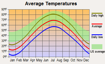
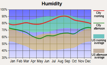
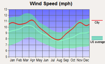
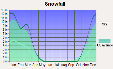
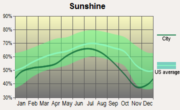
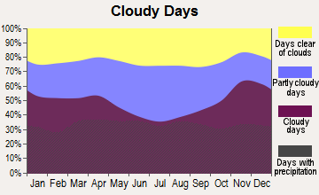
Average climate in Menominee, Wisconsin
Based on data reported by over 4,000 weather stations
Tornado activity:
Menominee-area historical tornado activity is slightly below Wisconsin state average. It is 11% smaller than the overall U.S. average.
On 8/19/1968, a category F4 (max. wind speeds 207-260 mph) tornado 29.5 miles away from the Menominee town center killed 2 people and injured 3 people and caused between $500,000 and $5,000,000 in damages.
On 9/26/1951, a category F4 tornado 33.0 miles away from the town center killed 6 people and injured 3 people and caused between $50,000 and $500,000 in damages.
Earthquake activity:
Menominee-area historical earthquake activity is significantly above Wisconsin state average. It is 81% smaller than the overall U.S. average.On 6/28/2004 at 06:10:52, a magnitude 4.2 (4.2 MW, Depth: 6.2 mi, Class: Light, Intensity: IV - V) earthquake occurred 240.9 miles away from the city center
On 5/2/2015 at 16:23:07, a magnitude 4.2 (4.2 MW, Depth: 2.8 mi) earthquake occurred 246.8 miles away from Menominee center
On 2/10/2010 at 09:59:35, a magnitude 3.8 (3.8 MW, Depth: 6.2 mi, Class: Light, Intensity: II - III) earthquake occurred 205.5 miles away from Menominee center
On 7/9/1975 at 14:54:15, a magnitude 4.6 (4.6 MB) earthquake occurred 363.0 miles away from Menominee center
On 1/31/1986 at 16:46:43, a magnitude 5.0 (5.0 MB, Class: Moderate, Intensity: VI - VII) earthquake occurred 441.8 miles away from Menominee center
On 9/25/1998 at 19:52:52, a magnitude 5.2 (4.8 MB, 4.3 MS, 5.2 LG, 4.5 MW, Depth: 3.1 mi) earthquake occurred 479.1 miles away from Menominee center
Magnitude types: regional Lg-wave magnitude (LG), body-wave magnitude (MB), surface-wave magnitude (MS), moment magnitude (MW)
Natural disasters:
The number of natural disasters in Menominee County (6) is a lot smaller than the US average (15).Major Disasters (Presidential) Declared: 2
Emergencies Declared: 3
Causes of natural disasters: Floods: 3, Storms: 3, Tornadoes: 2, Drought: 1, Hurricane: 1, Wind: 1, Other: 1 (Note: some incidents may be assigned to more than one category).
Hospitals and medical centers near Menominee:
- EVERGREEN CARE CTR (Nursing Home, about 13 miles away; SHAWANO, WI)
- BIRCH HILL CARE CENTER (Nursing Home, about 13 miles away; SHAWANO, WI)
- MANORCARE HEALTH SERVICES-SHAWANO (Nursing Home, about 13 miles away; SHAWANO, WI)
- FMC - SHAWANO (Dialysis Facility, about 13 miles away; SHAWANO, WI)
- WOODLAND VILLAGE NURSING HOME (Nursing Home, about 15 miles away; SURING, WI)
- WOODLAND VILLAGE HOME HEALTH (Home Health Center, about 15 miles away; SURING, WI)
Colleges/universities with over 2000 students nearest to Menominee:
- Northeast Wisconsin Technical College (about 39 miles; Green Bay, WI; Full-time enrollment: 6,069)
- Saint Norbert College (about 45 miles; De Pere, WI; FT enrollment: 2,324)
- University of Wisconsin-Green Bay (about 46 miles; Green Bay, WI; FT enrollment: 5,415)
- Fox Valley Technical College (about 47 miles; Appleton, WI; FT enrollment: 5,682)
- Lawrence University (about 49 miles; Appleton, WI; FT enrollment: 2,821)
- Northcentral Technical College (about 50 miles; Wausau, WI; FT enrollment: 3,356)
- University of Wisconsin-Stevens Point (about 54 miles; Stevens Point, WI; FT enrollment: 9,089)
Points of interest:
Notable locations in Menominee: Menominee Reservation Campground (A), Red River Camp (B), Menominee Tribal Rescue Service (C), South Branch Fire Department (D), Keshena Village Fire Department (E), Neopit Fire Department (F). Display/hide their locations on the map
Churches in Menominee include: Saint Joseph Church (A), Saint Michaels Catholic Church (B), Saint Anthonys Roman Catholic Church (C). Display/hide their locations on the map
Cemeteries: Rest Haven Cemetery (1), Saint Anthonys Cemetery (2), West Branch Cemetery (3), Saint Michael Cemetery (4). Display/hide their locations on the map
Lakes and reservoirs: Lake Neconish (A), Lake Noseum (B), Pine Lake (C), Perote Lake (D), Pestiga Lake (E), Pine Lake (F), Saint Joseph Lake (G), Pywaosit Lake (H). Display/hide their locations on the map
Rivers and creeks: Evergreen River (A), Oshkosh Creek (B), Tourtillotte Creek (C), Lazy Creek (D), McCall Creek (E), Minnow Creek (F), Squaw Creek (G), Founder Creek (H), Fish Creek (I). Display/hide their locations on the map
Park in Menominee: Spirit Rock Historic Marker (1). Display/hide its location on the map
| This town: | 3.2 people |
| Wisconsin: | 2.4 people |
| This town: | 76.9% |
| Whole state: | 64.4% |
| This town: | 14.7% |
| Whole state: | 7.3% |
Likely homosexual households (counted as self-reported same-sex unmarried-partner households)
- Lesbian couples: 0.5% of all households
- Gay men: 0.5% of all households
| This town: | 28.8% |
| Whole state: | 8.7% |
| This town: | 15.3% |
| Whole state: | 3.7% |
16 people in emergency and transitional shelters (with sleeping facilities) for people experiencing homelessness in 2010
35 people in local jails and other confinement facilities (including police lockups) in 2000
15 people in other noninstitutional group quarters in 2000
For population 15 years and over in Menominee:
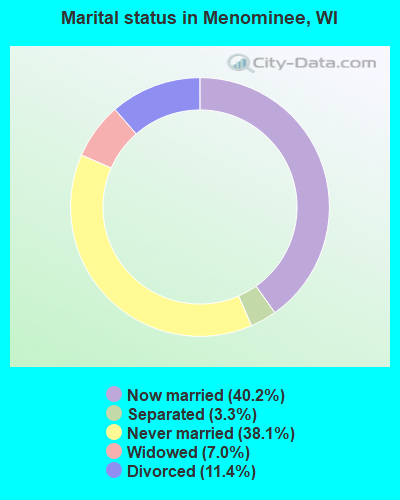
- Never married: 38.1%
- Now married: 40.2%
- Separated: 3.3%
- Widowed: 7.0%
- Divorced: 11.4%
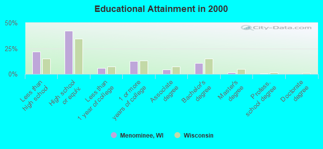
For population 25 years and over in Menominee:
- High school or higher: 78.2%
- Bachelor's degree or higher: 12.9%
- Graduate or professional degree: 2.2%
- Unemployed: 16.5%
- Mean travel time to work (commute): 18.4 minutes
| Here: | 9.6 |
| Wisconsin average: | 11.0 |
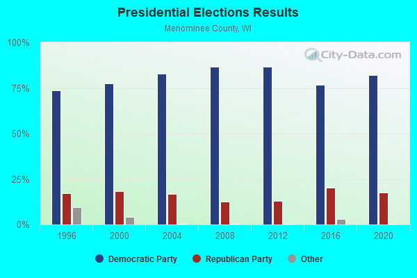
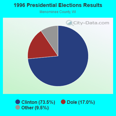
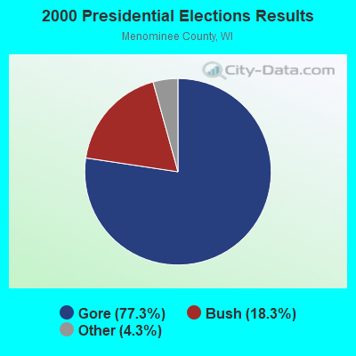
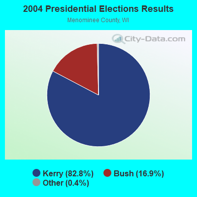
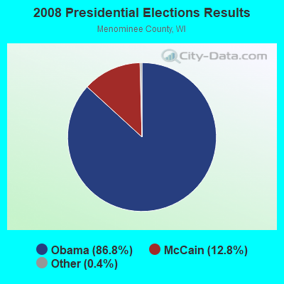
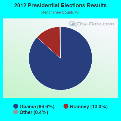
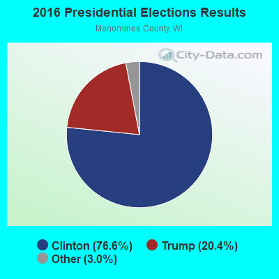
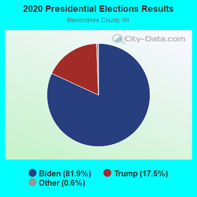
Graphs represent county-level data. Detailed 2008 Election Results
Religion statistics for Menominee, WI (based on Menominee County data)
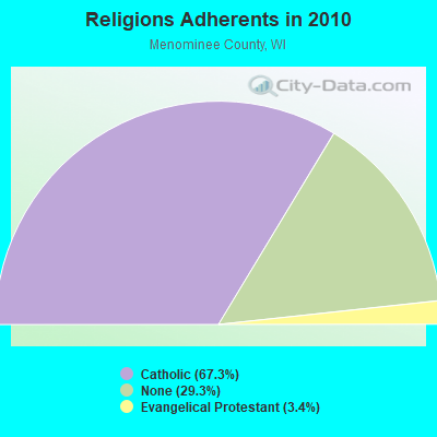
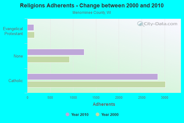
| Religion | Adherents | Congregations |
|---|---|---|
| Catholic | 2,850 | 2 |
| Evangelical Protestant | 142 | 2 |
| Other | 1 | - |
| None | 1,239 | - |
Food Environment Statistics:
| This county: | 2.17 / 10,000 pop. |
| Wisconsin: | 0.38 / 10,000 pop. |
| Here: | 4.35 / 10,000 pop. |
| Wisconsin: | 4.12 / 10,000 pop. |
| This county: | 12.3% |
| Wisconsin: | 7.6% |
| Menominee County: | 29.8% |
| Wisconsin: | 27.5% |
| Here: | 20.5% |
| Wisconsin: | 13.0% |
Strongest AM radio stations in Menominee:
- WSPT (1010 AM; 50 kW; STEVENS POINT, WI)
- WSAU (550 AM; 20 kW; WAUSAU, WI; Owner: WRIG, INC.)
- WNAM (1280 AM; 50 kW; NEENAH-MENASHA, WI; Owner: CUMULUS LICENSING CORP.)
- WTCH (960 AM; 1 kW; SHAWANO, WI; Owner: RESULTS BROADCASTING OF SHAWANO, INC.)
- WHBY (1150 AM; 25 kW; KIMBERLY, WI; Owner: WOODWARD COMMUNICATIONS, INC.)
- WFCL (1380 AM; 4 kW; CLINTONVILLE, WI; Owner: RESULTS BROADCASTING CORP.)
- WTAQ (1360 AM; 10 kW; GREEN BAY, WI; Owner: MIDWEST COMMUNICATIONS, INC.)
- WTMJ (620 AM; 50 kW; MILWAUKEE, WI; Owner: JOURNAL BROADCAST CORPORATION)
- WRIG (1390 AM; 10 kW; SCHOFIELD, WI; Owner: WRIG, INC.)
- WDUX (800 AM; 5 kW; WAUPACA, WI; Owner: LAIRD BROADCASTING COMPANY, INC.)
- WTCM (580 AM; 35 kW; TRAVERSE CITY, MI; Owner: WTCM RADIO, INC.)
- WEBC (560 AM; 50 kW; DULUTH, MN)
- WISN (1130 AM; 50 kW; MILWAUKEE, WI; Owner: CAPSTAR TX LIMITED PARTNERSHIP)
Strongest FM radio stations in Menominee:
- WRVM (102.7 FM; SURING, WI; Owner: WRVM, INC.)
- WOWN (99.3 FM; SHAWANO, WI; Owner: RESULTS BROADCASTING OF SHAWANO, INC.)
- WYCO (107.9 FM; WAUSAU, WI; Owner: SEEHAFER BROADCASTING CORPORATION)
- WRLO-FM (105.3 FM; ANTIGO, WI; Owner: NEWRADIO GROUP, LLC)
- WOZZ (93.5 FM; NEW LONDON, WI; Owner: MIDWEST COMMUNICATIONS, INC)
- WYNW (92.9 FM; BIRNAMWOOD, WI; Owner: STARBOARD BROADCASTING, INC.)
TV broadcast stations around Menominee:
- WIWB (Channel 14; SURING, WI; Owner: ACME TV LICENSES OF WISCONSIN, LLC)
- WYOW (Channel 34; EAGLE RIVER, WI; Owner: WAOW-WYOW TELEVISION, INC.)
- WFXS (Channel 55; WITTENBERG, WI; Owner: DAVIS TELEVISION WAUSAU, LLC)
- WTPX (Channel 46; ANTIGO, WI; Owner: PAXSON WAUSAU LICENSE, INC.)
- National Bridge Inventory (NBI) Statistics
- 9Number of bridges
- 102ft / 30.5mTotal length
- $908,000Total costs
- 5,645Total average daily traffic
- 366Total average daily truck traffic
- 6,765Total future (year 2038) average daily traffic
FCC Registered Antenna Towers:
3- Alicia Broeren, Along State Road 55 And County M (Lat: 44.995667 Lon: -88.599639), Type: 92.7, Structure height: 55078 m, Overall height: 91.4 m, Registrant: Cloud 1, Alicia.Broeren@bugtusselwireless.Com, Floor 2, Green- Bay, Phone: (920) 940-0144
- Alicia Broeren, Along State Road 55 And County M (Lat: 44.995667 Lon: -88.599639), Type: 92.7, Structure height: 55078 m, Overall height: 91.4 m, Registrant: Cloud 1, Alicia.Broeren@bugtusselwireless.Com, Floor 2, Green- Bay, Phone: (920) 940-0144
- Derek Barber, Along State Road 55 And County M (Lat: 44.995667 Lon: -88.599639), Type: 92.7, Structure height: 55078 m, Overall height: 91.4 m, Registrant: Cloud 1, Alicia.Broeren@bugtusselwireless.Com, Floor 2, Green- Bay, Phone: (920) 940-0144
FCC Registered Microwave Towers:
3- Hwy 55 and M East, Along State Road 55 And County M (Lat: 44.995667 Lon: -88.599639), Call Sign: WROD930, Grant Date: 09/30/2021, Expiration Date: 09/30/2031, Certifier: Steven J Schneider, Registrant: Intelpath, Hinsdale, IL 60522, Phone: (312) 841-9188, Fax: (920) 884-0836, Email:
- Hwy 55 and M East, Along State Road 55 And County M (Lat: 44.995667 Lon: -88.599639), Type: Gtower, Structure height: 89.6 m, Call Sign: WROD931,
Assigned Frequencies: 11485.0 MHz, 11485.0 MHz, 11485.0 MHz, 11485.0 MHz, 11485.0 MHz, 11485.0 MHz, 11485.0 MHz, 11405.0 MHz, 11405.0 MHz, 11405.0 MHz... (+14 more), Grant Date: 09/30/2021, Expiration Date: 09/30/2031, Certifier: Steven J Schneider, Registrant: Intelpath, Hinsdale, IL 60522, Phone: (312) 841-9188, Fax: (920) 884-0836, Email:
- 413 10th Avenue (Lat: 45.107472 Lon: -87.607028), Overall height: 54.6 m, Call Sign: WHY916,
Assigned Frequencies: 947.000 MHz, Grant Date: 08/14/1992, Expiration Date: 10/01/2028, Registrant: Radio Plus Bay Cities, LLC, 258 So Main Street, Fond Du Lac, WI 54935, Phone: (920) 906-9900, Email:
2002 - 2018 National Fire Incident Reporting System (NFIRS) incidents
- Fire incident types reported to NFIRS in Menominee, WI
- 11163.1%Structure Fires
- 5129.0%Other
- 105.7%Outside Fires
- 42.3%Mobile Property/Vehicle Fires
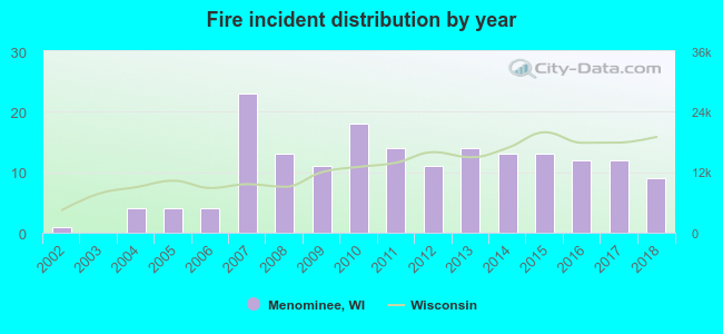 Based on the data from the years 2002 - 2018 the average number of fires per year is 10. The highest number of reported fire incidents - 23 took place in 2007, and the least - 0 in 2003. The data has a rising trend.
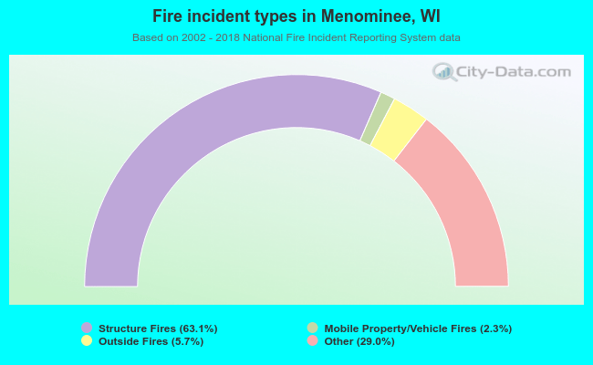 When looking into fire subcategories, the most reports belonged to: Structure Fires (63.1%), and Other (29.0%).
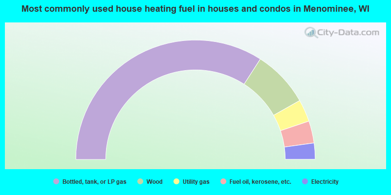
- 68.3%Bottled, tank, or LP gas
- 15.4%Wood
- 6.0%Utility gas
- 6.0%Fuel oil, kerosene, etc.
- 4.4%Electricity
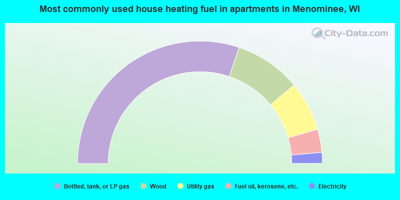
- 60.3%Bottled, tank, or LP gas
- 17.5%Wood
- 13.1%Utility gas
- 6.1%Fuel oil, kerosene, etc.
- 2.9%Electricity
Menominee compared to Wisconsin state average:
- Median house value below state average.
- Black race population percentage significantly below state average.
- Hispanic race population percentage below state average.
- Median age significantly below state average.
- Foreign-born population percentage below state average.
- Length of stay since moving in significantly above state average.
- Number of rooms per house significantly below state average.
- House age significantly below state average.
- Percentage of population with a bachelor's degree or higher below state average.