Lenroot, Wisconsin
Submit your own pictures of this town and show them to the world
- OSM Map
- Google Map
- MSN Map
Population change since 2000: +9.8%
 |
| Males: 666 | |
| Females: 613 |
| Median resident age: | 49.7 years |
| Wisconsin median age: | 42.6 years |
Zip codes: 54843.
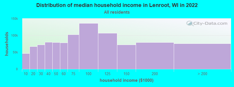
| Lenroot: | $61,094 |
| WI: | $70,996 |
Estimated per capita income in 2022: $39,497 (it was $19,230 in 2000)
Lenroot town income, earnings, and wages data
Estimated median house or condo value in 2022: $274,443 (it was $111,000 in 2000)
| Lenroot: | $274,443 |
| WI: | $252,800 |
Mean prices in 2022: all housing units: $277,850; detached houses: $285,245; townhouses or other attached units: $272,338; in 2-unit structures: $289,555; in 3-to-4-unit structures: $295,924; mobile homes: $105,132; occupied boats, rvs, vans, etc.: $24,097
Detailed information about poverty and poor residents in Lenroot, WI
Compare current foreclosures near Lenroot, WI:
| Photo | Address | Area | Beds / Baths | Price | Details |
|---|---|---|---|---|---|

|
#1
Beal Ave
Hayward, WI 54843
|
- sq. feet
|
- baths - beds |
show details | |

|
#2
Beal Ave Apt 4w
Hayward, WI 54843
|
- sq. feet
|
- baths - beds |
show details | |

|
#3
E 3rd St
Hayward, WI 54843
|
- sq. feet
|
- baths - beds |
show details | |

|
#4
Wisconsin
Hayward, WI 54843
|
- sq. feet
|
- baths - beds |
show details | |

|
#5
Pinewood Dr Lot 59
Hayward, WI 54843
|
- sq. feet
|
- baths - beds |
show details | |

|
#6
Salter Dr Lot 32
Hayward, WI 54843
|
- sq. feet
|
- baths - beds |
show details | |

|
#7
W Pfister Rd
Hayward, WI 54843
|
- sq. feet
|
- baths - beds |
show details | |

|
#8
N Gouch Circle Rd
Hayward, WI 54843
|
- sq. feet
|
- baths - beds |
show details | |

|
#9
N Stone Hill Rd
Hayward, WI 54843
|
- sq. feet
|
- baths - beds |
show details | |

|
Check over 1 million property listings on Foreclosure.com!
|
browse all offers | |||

- 1,22795.9%White alone
- 211.6%American Indian alone
- 161.3%Hispanic
- 141.1%Two or more races
- 10.08%Asian alone

Races in Lenroot detailed stats: ancestries, foreign born residents, place of birth
 Recent articles from our blog. Our writers, many of them Ph.D. graduates or candidates, create easy-to-read articles on a wide variety of topics.
Ancestries: German (34.8%), Irish (12.9%), Norwegian (12.4%), Swedish (8.1%), English (6.8%), Danish (5.2%).
Current Local Time: CST time zone
Land area: 81.7 square miles.
Population density: 16 people per square mile (very low).
19 residents are foreign born
| This town: | 1.6% |
| Wisconsin: | 3.6% |
| Lenroot town: | 1.2% ($1,308) |
| Wisconsin: | 2.0% ($2,245) |
Nearest city with pop. 50,000+: Duluth, MN  (57.5 miles , pop. 86,918).
Nearest city with pop. 200,000+: St. Paul, MN (113.3 miles , pop. 287,151).
Nearest city with pop. 1,000,000+: Chicago, IL (348.5 miles , pop. 2,896,016).
Nearest cities:
), ), ), ), )Latitude: 46.09 N, Longitude: 91.43 W
Area code commonly used in this area: 715
| Here: | 4.5% |
| Wisconsin: | 2.7% |

- Accommodation & food services (12.9%)
- Construction (11.9%)
- Health care (9.1%)
- Educational services (6.2%)
- Wood products (5.0%)
- Public administration (5.0%)
- Building material & garden equipment & supplies dealers (3.2%)

- Construction (20.5%)
- Accommodation & food services (8.5%)
- Wood products (6.6%)
- Public administration (5.1%)
- Educational services (5.1%)
- Building material & garden equipment & supplies dealers (3.9%)
- Administrative & support & waste management services (3.9%)

- Accommodation & food services (18.6%)
- Health care (16.7%)
- Educational services (7.6%)
- Social assistance (6.1%)
- Public administration (4.9%)
- Professional, scientific, technical services (4.5%)
- Motor vehicle & parts dealers (3.4%)

- Other management occupations, except farmers and farm managers (9.1%)
- Building and grounds cleaning and maintenance occupations (5.9%)
- Carpenters (5.5%)
- Retail sales workers, except cashiers (4.9%)
- Other production occupations, including supervisors (4.2%)
- Electrical equipment mechanics and other installation, maintenance, and repair workers, including supervisors (3.9%)
- Material recording, scheduling, dispatching, and distributing workers (3.7%)

- Carpenters (10.0%)
- Other management occupations, except farmers and farm managers (9.1%)
- Building and grounds cleaning and maintenance occupations (8.2%)
- Electrical equipment mechanics and other installation, maintenance, and repair workers, including supervisors (6.9%)
- Retail sales workers, except cashiers (6.6%)
- Other production occupations, including supervisors (5.4%)
- Other sales and related occupations, including supervisors (3.9%)

- Other management occupations, except farmers and farm managers (9.1%)
- Secretaries and administrative assistants (7.6%)
- Other office and administrative support workers, including supervisors (5.7%)
- Child care workers (5.3%)
- Waiters and waitresses (4.9%)
- Preschool, kindergarten, elementary, and middle school teachers (4.5%)
- Health technologists and technicians (4.5%)
Average climate in Lenroot, Wisconsin
Based on data reported by over 4,000 weather stations


Tornado activity:
Lenroot-area historical tornado activity is significantly below Wisconsin state average. It is 54% smaller than the overall U.S. average.
On 6/18/2001, a category F3 (max. wind speeds 158-206 mph) tornado 31.6 miles away from the Lenroot town center killed 2 people and injured 16 people and caused $10 million in damages.
On 7/30/1977, a category F4 (max. wind speeds 207-260 mph) tornado 58.0 miles away from the town center injured 20 people and caused between $5,000,000 and $50,000,000 in damages.
Earthquake activity:
Lenroot-area historical earthquake activity is significantly above Wisconsin state average. It is 69% smaller than the overall U.S. average.On 7/9/1975 at 14:54:15, a magnitude 4.6 (4.6 MB, Class: Light, Intensity: IV - V) earthquake occurred 223.7 miles away from the city center
On 6/5/1993 at 01:24:53, a magnitude 4.1 (4.1 LG, Depth: 6.2 mi) earthquake occurred 235.7 miles away from the city center
On 2/7/2020 at 18:30:28, a magnitude 3.3 (3.3 ML, Class: Light, Intensity: II - III) earthquake occurred 113.5 miles away from the city center
On 1/9/2020 at 18:16:48, a magnitude 3.3 (3.3 MB) earthquake occurred 116.5 miles away from the city center
On 4/8/2020 at 17:14:33, a magnitude 3.3 (3.3 ML) earthquake occurred 116.9 miles away from Lenroot center
On 3/2/2017 at 16:53:31, a magnitude 3.2 (3.2 ML) earthquake occurred 109.1 miles away from Lenroot center
Magnitude types: regional Lg-wave magnitude (LG), body-wave magnitude (MB), local magnitude (ML)
Natural disasters:
The number of natural disasters in Sawyer County (8) is smaller than the US average (15).Major Disasters (Presidential) Declared: 5
Emergencies Declared: 3
Causes of natural disasters: Floods: 4, Storms: 4, Tornadoes: 2, Winds: 2, Drought: 1, Hurricane: 1, Other: 1 (Note: some incidents may be assigned to more than one category).
Colleges/universities with over 2000 students nearest to Lenroot:
- Wisconsin Indianhead Technical College (about 34 miles; Shell Lake, WI; Full-time enrollment: 2,414)
- University of Wisconsin-Superior (about 54 miles; Superior, WI; FT enrollment: 2,302)
- Lake Superior College (about 59 miles; Duluth, MN; FT enrollment: 3,768)
- University of Minnesota-Duluth (about 59 miles; Duluth, MN; FT enrollment: 10,612)
- The College of Saint Scholastica (about 60 miles; Duluth, MN; FT enrollment: 3,762)
- University of Wisconsin-Stout (about 87 miles; Menomonie, WI; FT enrollment: 8,120)
- University of Wisconsin-Eau Claire (about 90 miles; Eau Claire, WI; FT enrollment: 10,143)
Points of interest:
Notable location: Lenroot Landing (A). Display/hide its location on the map
Cemeteries: Riverside Cemetery (1), Trinity Cemetery (2). Display/hide their locations on the map
Lakes and reservoirs: Pacwawong Lake (A), Osgood Lake (B), Sabin Lake (C), Porcupine Lake (D), Silverthorn Lake (E), Smith Lake (F), Bullhead Lake (G), Mossback Lake (H). Display/hide their locations on the map
Streams, rivers, and creeks: Mosquito Brook (A), Tag-Alder Creek (B), McDermott Brook (C), Cold Brook (D). Display/hide their locations on the map
Parks in Lenroot include: Eytcheson Park (1), Totagatic River State Wildlife Managemnet Area (2), Saint Croix National Scenic River (3). Display/hide their locations on the map
| This town: | 2.3 people |
| Wisconsin: | 2.4 people |
| This town: | 72.6% |
| Whole state: | 64.4% |
| This town: | 6.6% |
| Whole state: | 7.3% |
Likely homosexual households (counted as self-reported same-sex unmarried-partner households)
- Lesbian couples: 0.4% of all households
- Gay men: 1.1% of all households
| This town: | 8.7% |
| Whole state: | 8.7% |
| This town: | 3.9% |
| Whole state: | 3.7% |
For population 15 years and over in Lenroot:

- Never married: 18.7%
- Now married: 62.5%
- Separated: 0.8%
- Widowed: 7.2%
- Divorced: 10.9%
For population 25 years and over in Lenroot:
- High school or higher: 90.0%
- Bachelor's degree or higher: 17.3%
- Graduate or professional degree: 7.0%
- Unemployed: 4.8%
- Mean travel time to work (commute): 16.0 minutes


| Here: | 9.5 |
| Wisconsin average: | 11.0 |
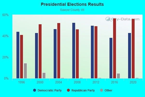
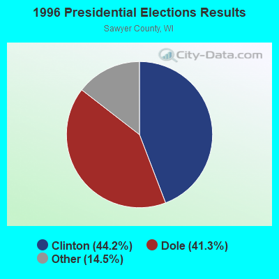
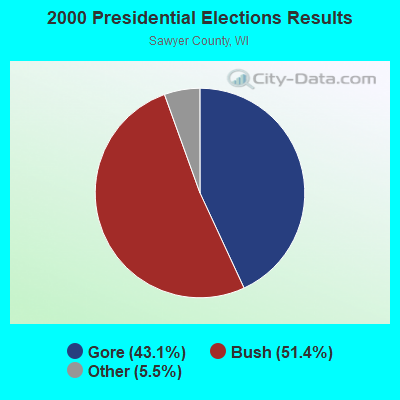
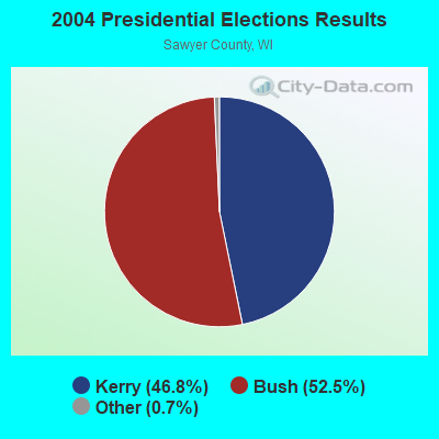
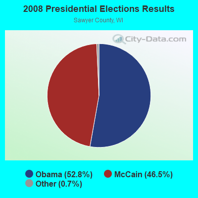
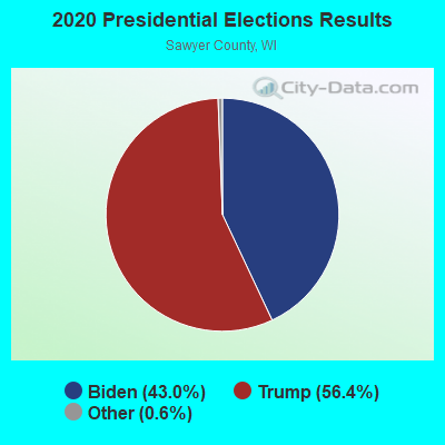
Graphs represent county-level data. Detailed 2008 Election Results
Religion statistics for Lenroot, WI (based on Sawyer County data)
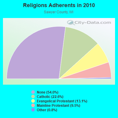
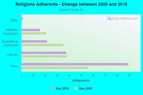
| Religion | Adherents | Congregations |
|---|---|---|
| Catholic | 3,747 | 6 |
| Evangelical Protestant | 2,162 | 18 |
| Mainline Protestant | 1,568 | 11 |
| Other | 136 | 2 |
| None | 8,944 | - |
Food Environment Statistics:
| Here: | 2.93 / 10,000 pop. |
| State: | 1.86 / 10,000 pop. |
| Sawyer County: | 0.59 / 10,000 pop. |
| Wisconsin: | 0.11 / 10,000 pop. |
| Sawyer County: | 1.17 / 10,000 pop. |
| Wisconsin: | 0.38 / 10,000 pop. |
| Sawyer County: | 9.96 / 10,000 pop. |
| Wisconsin: | 4.12 / 10,000 pop. |
| Sawyer County: | 27.54 / 10,000 pop. |
| Wisconsin: | 8.64 / 10,000 pop. |
| Sawyer County: | 9.2% |
| Wisconsin: | 7.6% |
| Sawyer County: | 28.1% |
| Wisconsin: | 27.5% |
| Sawyer County: | 15.2% |
| State: | 13.0% |
Strongest AM radio stations in Lenroot:
- WHSM (910 AM; 5 kW; HAYWARD, WI; Owner: QB BROADCASTING, LTD.)
- WEBC (560 AM; 50 kW; DULUTH, MN)
- WDSM (710 AM; 10 kW; SUPERIOR, WI; Owner: MIDWEST COMMUNICATIONS, INC.)
- WCCO (830 AM; 50 kW; MINNEAPOLIS, MN; Owner: INFINITY MEDIA CORPORATION)
- WWJC (850 AM; daytime; 10 kW; DULUTH, MN; Owner: WWJC, INC.)
- WCTS (1030 AM; 50 kW; MAPLEWOOD, MN; Owner: CNTL. BAPT. THEO/AL SEMI MINNEAPOLIS)
- KSTP (1500 AM; 50 kW; ST. PAUL, MN; Owner: KSTP-AM, LLC (DELAWARE))
- WAQE (1090 AM; daytime; 5 kW; RICE LAKE, WI; Owner: TKC, INC.)
- WSPT (1010 AM; 50 kW; STEVENS POINT, WI)
- KDAL (610 AM; 5 kW; DULUTH, MN; Owner: MIDWEST COMMUNICATIONS, INC.)
- KTIS (900 AM; 25 kW; MINNEAPOLIS, MN; Owner: NORTHWESTERN COLLEGE)
- KFAN (1130 AM; 50 kW; MINNEAPOLIS, MN; Owner: AMFM RADIO LICENSES, L.L.C.)
- WSAU (550 AM; 20 kW; WAUSAU, WI; Owner: WRIG, INC.)
Strongest FM radio stations in Lenroot:
- WHSM-FM (101.1 FM; HAYWARD, WI; Owner: QB BROADCASTING, LTD.)
- WRLS-FM (92.3 FM; HAYWARD, WI; Owner: VACATIONLAND BROADCASTER, INC.)
- WOJB (88.9 FM; RESERVE, WI; Owner: LAC COURTE OREILLES OJIBWA PUBLIC)
- WHSA (89.9 FM; BRULE, WI; Owner: STATE OF WISCONSIN - EDUCATIONAL COMMUNICATIONS BOARD)
- W230AN (93.9 FM; HAYWARD, WI; Owner: NORTHWESTERN COLLEGE)
TV broadcast stations around Lenroot:
- K31GH (Channel 31; HAYWARD, WI; Owner: KQDS ACQUISITION CORP.)
- National Bridge Inventory (NBI) Statistics
- 6Number of bridges
- 49ft / 15.4mTotal length
- $368,000Total costs
- 5,951Total average daily traffic
- 535Total average daily truck traffic
- 7,065Total future (year 2038) average daily traffic

- 69.2%Bottled, tank, or LP gas
- 16.0%Wood
- 7.5%Fuel oil, kerosene, etc.
- 4.4%Electricity
- 2.2%Utility gas
- 0.7%Other fuel

- 64.0%Bottled, tank, or LP gas
- 12.0%Electricity
- 8.0%Fuel oil, kerosene, etc.
- 8.0%Wood
- 4.0%Utility gas
- 4.0%Other fuel
Lenroot compared to Wisconsin state average:
- Unemployed percentage below state average.
- Black race population percentage significantly below state average.
- Hispanic race population percentage significantly below state average.
- Median age above state average.
- Foreign-born population percentage significantly below state average.
- Renting percentage significantly below state average.
- Length of stay since moving in significantly above state average.
- Number of rooms per house significantly below state average.
- House age significantly below state average.
- Number of college students significantly below state average.