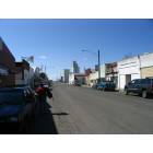
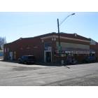
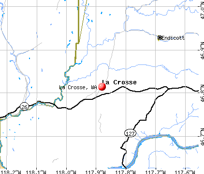
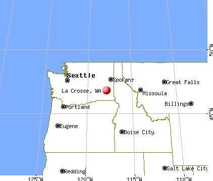
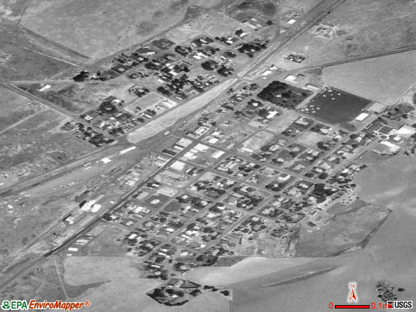
La Crosse, Washington
Submit your own pictures of this town and show them to the world
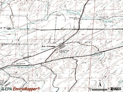
- OSM Map
- General Map
- Google Map
- MSN Map
Population change since 2000: -22.6%
 |
| Males: 156 | |
| Females: 138 |
| Median resident age: | 56.3 years |
| Washington median age: | 38.4 years |
Zip codes: 99143.
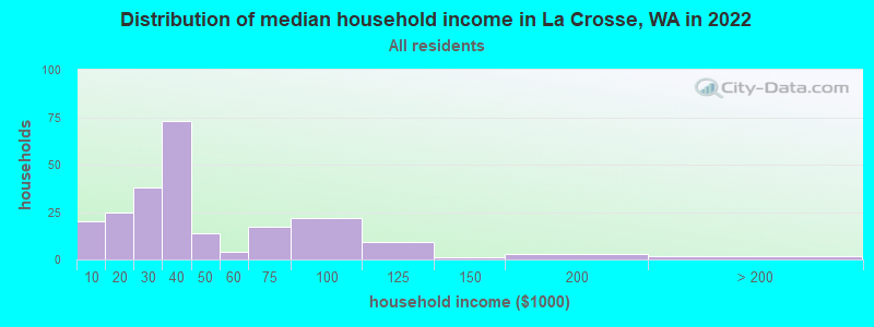
| La Crosse: | $31,710 |
| WA: | $91,306 |
Estimated per capita income in 2022: $22,026 (it was $16,656 in 2000)
La Crosse town income, earnings, and wages data
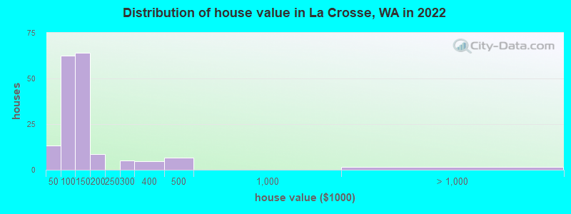
Estimated median house or condo value in 2022: $130,525 (it was $60,000 in 2000)
| La Crosse: | $130,525 |
| WA: | $569,500 |
Mean prices in 2022: all housing units: $114,356; detached houses: $134,589; mobile homes: $39,409
Median gross rent in 2022: $609.
(27.4% for White Non-Hispanic residents, 32.4% for two or more races residents)
Detailed information about poverty and poor residents in La Crosse, WA


- 26863.5%White alone
- 8520.1%Other race alone
- 4811.4%Hispanic
- 378.8%Two or more races
- 51.2%American Indian alone
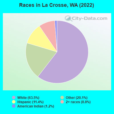
Races in La Crosse detailed stats: ancestries, foreign born residents, place of birth
 Recent articles from our blog. Our writers, many of them Ph.D. graduates or candidates, create easy-to-read articles on a wide variety of topics.

 | ****How many others have been priced out of living in western WA/Seattle area? (104 replies) |
| Safest little towns around Spokane. (28 replies) |
Latest news from La Crosse, WA collected exclusively by city-data.com from local newspapers, TV, and radio stations
Ancestries: American (38.6%), German (19.3%), European (13.0%), English (10.2%), Irish (4.3%), French Canadian (1.6%).
Current Local Time: PST time zone
Elevation: 1481 feet
Land area: 0.34 square miles.
Population density: 852 people per square mile (low).
29 residents are foreign born (3.3% North America, 1.9% Asia, 1.4% Latin America).
| This town: | 6.9% |
| Washington: | 14.9% |
Median real estate property taxes paid for housing units with mortgages in 2022: $1,612 (0.9%)
Median real estate property taxes paid for housing units with no mortgage in 2022: $1,223 (1.0%)
Nearest city with pop. 50,000+: Spokane, WA  (63.4 miles , pop. 195,629).
Nearest city with pop. 200,000+: East Seattle, WA (208.8 miles , pop. 480,100).
Nearest city with pop. 1,000,000+: Los Angeles, CA (880.8 miles , pop. 3,694,820).
Nearest cities:
), Latitude: 46.81 N, Longitude: 117.88 W
Area code commonly used in this area: 509
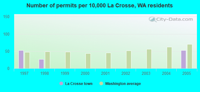
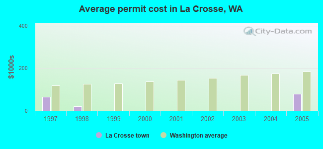
Single-family new house construction building permits:
- 2005: 2 buildings, average cost: $80,000
- 1998: 1 building, cost: $20,000
- 1997: 2 buildings, average cost: $66,100
| Here: | 4.8% |
| Washington: | 4.6% |
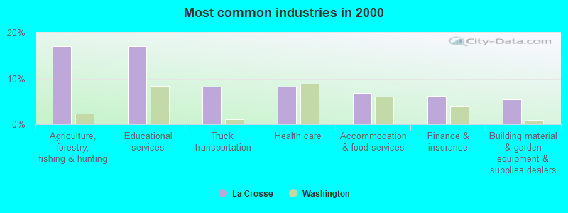
- Agriculture, forestry, fishing & hunting (17.1%)
- Educational services (17.1%)
- Truck transportation (8.2%)
- Health care (8.2%)
- Accommodation & food services (6.8%)
- Finance & insurance (6.2%)
- Building material & garden equipment & supplies dealers (5.5%)
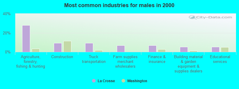
- Agriculture, forestry, fishing & hunting (28.0%)
- Construction (9.3%)
- Truck transportation (9.3%)
- Farm supplies merchant wholesalers (6.7%)
- Finance & insurance (6.7%)
- Building material & garden equipment & supplies dealers (5.3%)
- Educational services (5.3%)
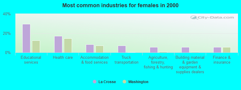
- Educational services (29.6%)
- Health care (16.9%)
- Accommodation & food services (8.5%)
- Truck transportation (7.0%)
- Agriculture, forestry, fishing & hunting (5.6%)
- Building material & garden equipment & supplies dealers (5.6%)
- Finance & insurance (5.6%)
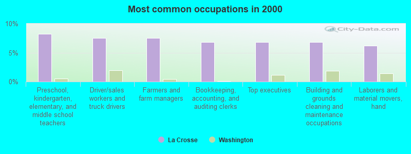
- Preschool, kindergarten, elementary, and middle school teachers (8.2%)
- Driver/sales workers and truck drivers (7.5%)
- Farmers and farm managers (7.5%)
- Bookkeeping, accounting, and auditing clerks (6.8%)
- Top executives (6.8%)
- Building and grounds cleaning and maintenance occupations (6.8%)
- Laborers and material movers, hand (6.2%)
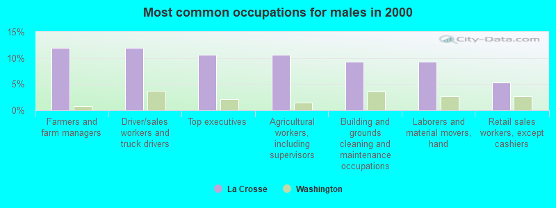
- Farmers and farm managers (12.0%)
- Driver/sales workers and truck drivers (12.0%)
- Top executives (10.7%)
- Agricultural workers, including supervisors (10.7%)
- Building and grounds cleaning and maintenance occupations (9.3%)
- Laborers and material movers, hand (9.3%)
- Retail sales workers, except cashiers (5.3%)
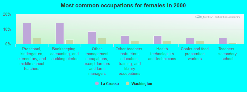
- Preschool, kindergarten, elementary, and middle school teachers (14.1%)
- Bookkeeping, accounting, and auditing clerks (14.1%)
- Other management occupations, except farmers and farm managers (8.5%)
- Other teachers, instructors, education, training, and library occupations (5.6%)
- Health technologists and technicians (5.6%)
- Cooks and food preparation workers (4.2%)
- Teachers, secondary school (4.2%)
Average climate in La Crosse, Washington
Based on data reported by over 4,000 weather stations


(lower is better)
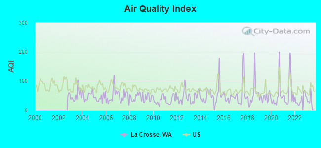
Air Quality Index (AQI) level in 2022 was 37.1. This is significantly better than average.
| City: | 37.1 |
| U.S.: | 72.6 |
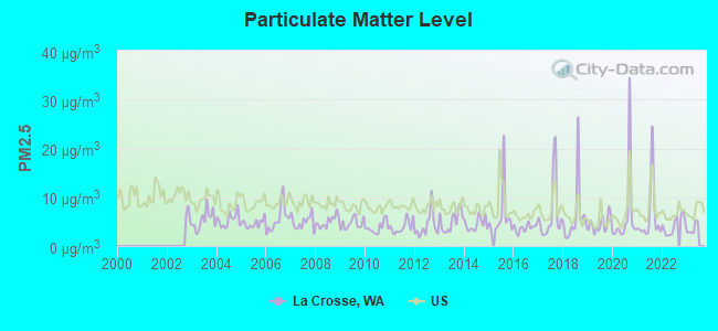
Particulate Matter (PM2.5) [µg/m3] level in 2022 was 4.21. This is significantly better than average. Closest monitor was 24.8 miles away from the city center.
| City: | 4.21 |
| U.S.: | 8.11 |
Earthquake activity:
La Crosse-area historical earthquake activity is significantly above Washington state average. It is 1129% greater than the overall U.S. average.On 10/28/1983 at 14:06:06, a magnitude 7.3 (6.2 MB, 7.3 MS, 7.0 MW, Class: Major, Intensity: VIII - XII) earthquake occurred 273.8 miles away from the city center, causing 2 deaths (2 shaking deaths) and 3 injuries, causing $15,000,000 total damage
On 4/13/1949 at 19:55:42, a magnitude 7.0 (7.0 UK) earthquake occurred 219.8 miles away from the city center, causing $80,000,000 total damage
On 8/18/1959 at 06:37:13, a magnitude 7.7 (7.7 UK) earthquake occurred 382.0 miles away from the city center, causing $26,000,000 total damage
On 2/28/2001 at 18:54:32, a magnitude 6.8 (6.5 MB, 6.6 MS, 6.8 MW, Class: Strong, Intensity: VII - IX) earthquake occurred 222.7 miles away from the city center, causing $2,000,000,000 total damage and $305,000,000 insured losses
On 2/28/2001 at 18:54:32, a magnitude 6.8 (6.8 MD, Depth: 32.2 mi) earthquake occurred 229.8 miles away from the city center
On 4/29/1965 at 15:28:43, a magnitude 6.6 (6.6 UK) earthquake occurred 212.6 miles away from the city center, causing $28,000,000 total damage
Magnitude types: body-wave magnitude (MB), duration magnitude (MD), surface-wave magnitude (MS), moment magnitude (MW)
Natural disasters:
The number of natural disasters in Whitman County (14) is near the US average (15).Major Disasters (Presidential) Declared: 12
Emergencies Declared: 2
Causes of natural disasters: Floods: 8, Storms: 5, Mudslides: 3, Heavy Rains: 2, Snows: 2, Winter Storms: 2, Drought: 1, Fire: 1, Hurricane: 1, Landslide: 1, Volcanic Eruption: 1, Wind: 1, Other: 1 (Note: some incidents may be assigned to more than one category).
Colleges/universities with over 2000 students nearest to La Crosse:
- Washington State University (about 35 miles; Pullman, WA; Full-time enrollment: 25,055)
- University of Idaho (about 41 miles; Moscow, ID; FT enrollment: 10,416)
- Eastern Washington University (about 49 miles; Cheney, WA; FT enrollment: 11,643)
- Lewis-Clark State College (about 50 miles; Lewiston, ID; FT enrollment: 3,199)
- Walla Walla Community College (about 55 miles; Walla Walla, WA; FT enrollment: 4,263)
- Spokane Falls Community College (about 63 miles; Spokane, WA; FT enrollment: 6,052)
- Gonzaga University (about 64 miles; Spokane, WA; FT enrollment: 6,780)
Public high school in La Crosse:
- LACROSSE HIGH SCHOOL (Location: 111 HILL AVENUE, Grades: 9-12)
Public elementary/middle school in La Crosse:
- LACROSSE ELEMENTARY SCHOOL (Location: 111 HILL AVE, Grades: KG-8)
Points of interest:
Notable location: Lacrosse City Fire Department (A). Display/hide its location on the map
| This town: | 2.0 people |
| Washington: | 2.5 people |
| This town: | 62.7% |
| Whole state: | 64.4% |
| This town: | 3.3% |
| Whole state: | 7.7% |
No gay or lesbian households reported
For population 15 years and over in La Crosse:

- Never married: 19.8%
- Now married: 49.3%
- Separated: 0.6%
- Widowed: 4.5%
- Divorced: 25.9%
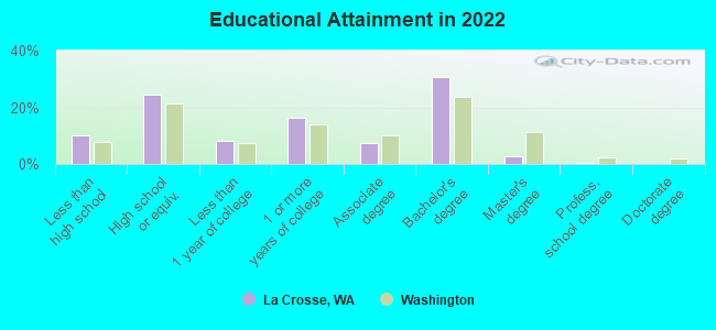
For population 25 years and over in La Crosse:
- High school or higher: 88.2%
- Bachelor's degree or higher: 32.0%
- Graduate or professional degree: 3.0%
- Unemployed: 6.4%
- Mean travel time to work (commute): 21.2 minutes
| Here: | 11.0 |
| Washington average: | 11.6 |
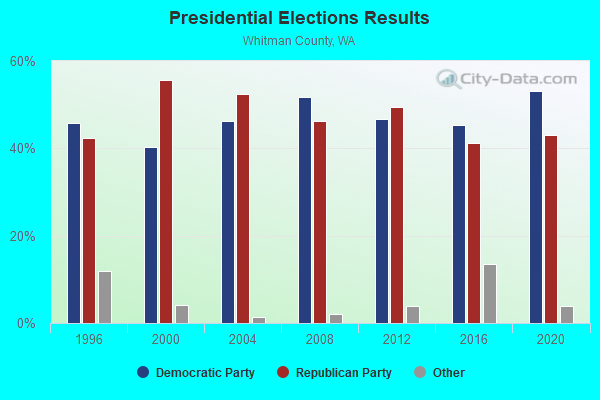
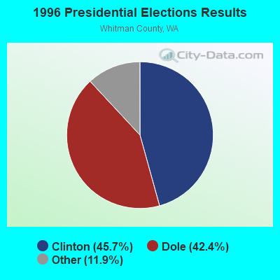
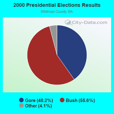
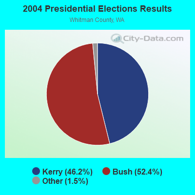
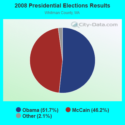
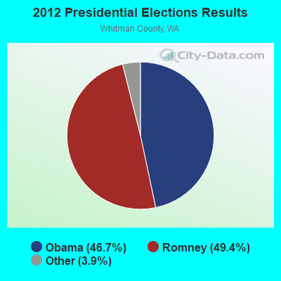
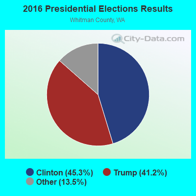
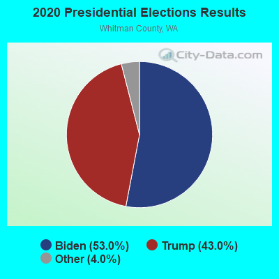
Graphs represent county-level data. Detailed 2008 Election Results
Religion statistics for La Crosse, WA (based on Whitman County data)
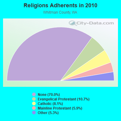
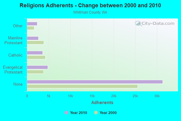
| Religion | Adherents | Congregations |
|---|---|---|
| Evangelical Protestant | 4,782 | 35 |
| Catholic | 3,628 | 9 |
| Mainline Protestant | 2,644 | 20 |
| Other | 2,388 | 10 |
| None | 31,334 | - |
Food Environment Statistics:
| Here: | 2.94 / 10,000 pop. |
| Washington: | 2.06 / 10,000 pop. |
| Whitman County: | 0.74 / 10,000 pop. |
| Washington: | 1.18 / 10,000 pop. |
| Whitman County: | 1.96 / 10,000 pop. |
| State: | 2.67 / 10,000 pop. |
| This county: | 7.85 / 10,000 pop. |
| Washington: | 8.26 / 10,000 pop. |
| Whitman County: | 5.4% |
| Washington: | 7.7% |
| Whitman County: | 24.1% |
| Washington: | 25.7% |
| This county: | 8.1% |
| Washington: | 13.9% |
Health and Nutrition:
| This city: | 51.6% |
| Washington: | 49.9% |
| This city: | 48.9% |
| State: | 47.2% |
| La Crosse: | 29.1 |
| Washington: | 28.4 |
| La Crosse: | 22.5% |
| State: | 20.9% |
| La Crosse: | 8.7% |
| Washington: | 10.5% |
| This city: | 6.8 |
| State: | 6.8 |
| La Crosse: | 38.4% |
| Washington: | 32.8% |
| La Crosse: | 56.5% |
| Washington: | 56.8% |
| This city: | 76.5% |
| Washington: | 79.4% |
More about Health and Nutrition of La Crosse, WA Residents
| Local government employment and payroll (March 2007) | |||||
| Function | Full-time employees | Monthly full-time payroll | Average yearly full-time wage | Part-time employees | Monthly part-time payroll |
|---|---|---|---|---|---|
| Water Supply | 1 | $2,608 | $31,296 | 0 | $0 |
| Firefighters | 0 | $0 | 2 | $102 | |
| Parks and Recreation | 0 | $0 | 1 | $1,777 | |
| Financial Administration | 0 | $0 | 1 | $1,795 | |
| Other Government Administration | 0 | $0 | 7 | $255 | |
| Police Protection - Officers | 0 | $0 | 1 | $500 | |
| Totals for Government | 1 | $2,608 | $31,296 | 12 | $4,429 |
La Crosse government finances - Expenditure in 2017 (per resident):
- Current Operations - Water Utilities: $76,000 ($258.50)
Sewerage: $71,000 ($241.50)
Regular Highways: $34,000 ($115.65)
Miscellaneous Commercial Activities - Other: $26,000 ($88.44)
Financial Administration: $22,000 ($74.83)
Parks and Recreation: $22,000 ($74.83)
Central Staff Services: $11,000 ($37.41)
General Public Buildings: $8,000 ($27.21)
Police Protection: $4,000 ($13.61)
Solid Waste Management: $4,000 ($13.61)
Local Fire Protection: $3,000 ($10.20)
Judicial and Legal Services: $1,000 ($3.40)
- General - Interest on Debt: $7,000 ($23.81)
- Other Capital Outlay - Sewerage: $567,000 ($1928.57)
Water Utilities: $152,000 ($517.01)
- Total Salaries and Wages: $106,000 ($360.54)
- Water Utilities - Interest on Debt: $55,000 ($187.07)
La Crosse government finances - Revenue in 2017 (per resident):
- Charges - Sewerage: $101,000 ($343.54)
Miscellaneous Commercial Activities: $2,000 ($6.80)
- Miscellaneous - Rents: $6,000 ($20.41)
Donations From Private Sources: $1,000 ($3.40)
Interest Earnings: $0 ($0.00)
- Revenue - Water Utilities: $147,000 ($500.00)
- State Intergovernmental - Housing and Community Development: $285,000 ($969.39)
Other: $191,000 ($649.66)
Highways: $8,000 ($27.21)
General Local Government Support: $4,000 ($13.61)
- Tax - General Sales and Gross Receipts: $42,000 ($142.86)
Public Utilities Sales: $36,000 ($122.45)
Property: $32,000 ($108.84)
Other License: $3,000 ($10.20)
Documentary and Stock Transfer: $1,000 ($3.40)
La Crosse government finances - Debt in 2017 (per resident):
- Long Term Debt - Beginning Outstanding - Unspecified Public Purpose: $1,535,000 ($5221.09)
Outstanding Unspecified Public Purpose: $977,000 ($3323.13)
Retired Unspecified Public Purpose: $833,000 ($2833.33)
Issue, Unspecified Public Purpose: $275,000 ($935.37)
Strongest AM radio stations in La Crosse:
- KQQQ (1150 AM; 25 kW; PULLMAN, WA; Owner: RADIO PALOUSE, INC.)
- KMAX (840 AM; 10 kW; COLFAX, WA; Owner: PALOUSE COUNTRY, INC.)
- KGA (1510 AM; 50 kW; SPOKANE, WA; Owner: CITADEL BROADCASTING COMPANY)
- KTBI (810 AM; daytime; 50 kW; EPHRATA, WA; Owner: TACOMA BROADCASTERS, INCORPORATED)
- KXLY (920 AM; 20 kW; SPOKANE, WA; Owner: SPOKANE RADIO, INC.)
- KWSU (1250 AM; 5 kW; PULLMAN, WA; Owner: WASHINGTON STATE UNIVERSITY)
- KMJY (700 AM; 10 kW; NEWPORT, WA; Owner: JAMES E. AND HELEN G. STARGEL)
- KFLD (870 AM; 10 kW; PASCO, WA; Owner: CAPSTAR TX LIMITED PARTNERSHIP)
- KOZE (950 AM; 5 kW; LEWISTON, ID; Owner: 4-K RADIO, INC.)
- KQNT (590 AM; 5 kW; SPOKANE, WA; Owner: CAPSTAR TX LIMITED PARTNERSHIP)
- KERR (750 AM; 50 kW; POLSON, MT; Owner: ANDERSON RADIO BROADCASTING, INC.)
- KJRB (790 AM; 5 kW; SPOKANE, WA; Owner: CITADEL BROADCASTING COMPANY)
- KVNI (1080 AM; 10 kW; COEUR D' ALENE, ID; Owner: QUEENB RADIO, INC.)
Strongest FM radio stations in La Crosse:
- KZHR (92.5 FM; DAYTON, WA; Owner: COMMONWEALTH LICENSE SUBSIDIARY, LLC)
- KHTR (104.3 FM; PULLMAN, WA; Owner: RADIO PALOUSE, INC.)
- KRAO-FM (102.5 FM; COLFAX, WA; Owner: PALOUSE COUNTRY, INC.)
- KDRK-FM (93.7 FM; SPOKANE, WA; Owner: CITADEL BROADCASTING COMPANY)
- KIXZ-FM (96.1 FM; OPPORTUNITY, WA; Owner: CAPSTAR TX LIMITED PARTNERSHIP)
- KPBX-FM (91.1 FM; SPOKANE, WA; Owner: SPOKANE PUBLIC RADIO, INC.)
- KMBI-FM (107.9 FM; SPOKANE, WA; Owner: THE MOODY BIBLE INSTITUTE OF CHICAGO)
- KZZU-FM (92.9 FM; SPOKANE, WA; Owner: QUEENB)
- KISC (98.1 FM; SPOKANE, WA; Owner: CAPSTAR TX LIMITED PARTNERSHIP)
- KEYF-FM (101.1 FM; CHENEY, WA; Owner: CITADEL BROADCASTING COMPANY)
- KZBD (105.7 FM; SPOKANE, WA; Owner: CITADEL BROADCASTING COMPANY)
- KCLK-FM (94.1 FM; CLARKSTON, WA; Owner: CLARKSTON BROADCASTERS, INC.)
- KVAB (102.9 FM; CLARKSTON, WA; Owner: CLARKSTON BROADCASTERS, INC.)
- KMOK (106.9 FM; LEWISTON, ID; Owner: IDA-VEND COMPANY, INC.)
- KZZL-FM (99.5 FM; PULLMAN, WA; Owner: PALOUSE COUNTRY, INC.)
- KNWV (90.5 FM; CLARKSTON, WA; Owner: WASHINGTON STATE UNIVERSITY)
- KRLF (88.5 FM; PULLMAN, WA; Owner: LIVING FAITH F/SHIP EDUC. MINISTRIES)
- National Bridge Inventory (NBI) Statistics
- 8Number of bridges
- 66ft / 20.1mTotal length
- $17,235,000Total costs
- 6,082Total average daily traffic
- 1,182Total average daily truck traffic
- 6,760Total future (year 2039) average daily traffic
FCC Registered Microwave Towers:
3- La Crosse, 2808 Scharpenburg Road (Lat: 46.816306 Lon: -117.845583), Type: Mast, Structure height: 44.8 m, Overall height: 47.3 m, Call Sign: WQKQ364,
Assigned Frequencies: 10715.0 MHz, Grant Date: 08/11/2009, Expiration Date: 08/11/2019, Cancellation Date: 06/13/2017, Certifier: Don Houghton, Registrant: At&t Mobility LLC, 3300 E. Renner Road, B3132, Richardson, TX 75082, Phone: (855) 699-7073, Fax: (972) 907-1131, Email:
- Lacrosse, Lat: 46.841167 Lon: -117.871167, Type: Ltower, Structure height: 3 m, Call Sign: WQVS897,
Assigned Frequencies: 11425.0 MHz, 11425.0 MHz, Grant Date: 05/04/2015, Expiration Date: 05/04/2025, Certifier: Keith Scheffer, Registrant: Startouch, Inc., 1354 Pacific Place, Suite 102, Ferndale, WA 98248, Phone: (360) 543-5679, Fax: (360) 384-3867, Email:
- LA CROSSE R, Snow Hill (Lat: 46.820694 Lon: -117.906028), Overall height: 9.1 m, Call Sign: WLL434, Licensee ID: L00007777,
Assigned Frequencies: 2128.00 MHz, 2178.00 MHz, Grant Date: 01/09/2001, Expiration Date: 02/01/2011, Cancellation Date: 04/09/2011, Registrant: Pioneer Telephone Company, Main Street, La Crosse, WA 99143
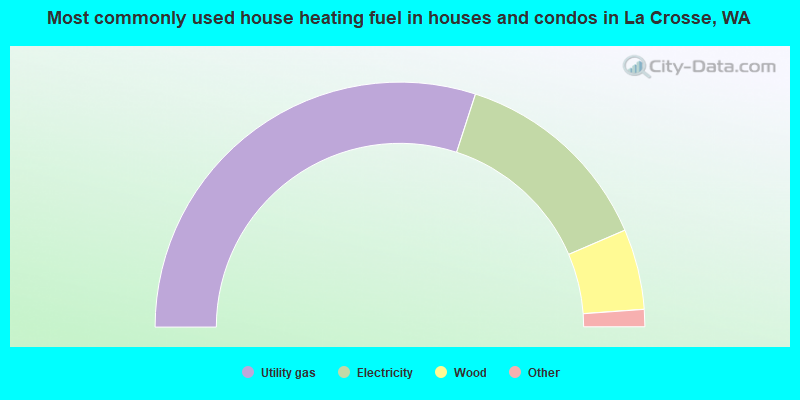
- 60.4%Utility gas
- 27.3%Electricity
- 10.7%Wood
- 1.1%Fuel oil, kerosene, etc.
- 0.5%Coal or coke
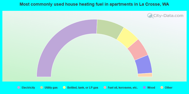
- 52.6%Electricity
- 15.8%Utility gas
- 10.5%Bottled, tank, or LP gas
- 10.5%Fuel oil, kerosene, etc.
- 10.5%Wood
La Crosse compared to Washington state average:
- Median household income significantly below state average.
- Median house value significantly below state average.
- Unemployed percentage below state average.
- Black race population percentage significantly below state average.
- Median age significantly above state average.
- Foreign-born population percentage below state average.
- Renting percentage below state average.
- Length of stay since moving in significantly above state average.
- Number of rooms per house above state average.
- House age above state average.
- Number of college students below state average.