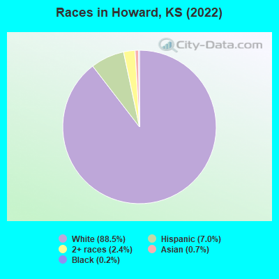
Percentage of residents living in poverty in 2022: 23.9%
(22.2% for White Non-Hispanic residents, 47.1% for Hispanic or Latino residents, 9.1% for two or more races residents)
According to our research of Kansas and other state lists, there were 3 registered sex offenders living in Howard, Kansas as of June 08, 2024. The ratio of all residents to sex offenders in Howard is 260 to 1. The ratio of registered sex offenders to all residents in this city is near the state average.
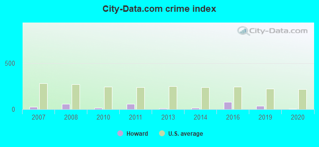
Crime rates in Howard by year
Type
2010
2011
2013
2014
2016
2019
2020
Murders (per 100,000)
0 (0.0)
0 (0.0)
0 (0.0)
0 (0.0)
0 (0.0)
0 (0.0)
0 (0.0)
Rapes (per 100,000)
0 (0.0)
0 (0.0)
0 (0.0)
0 (0.0)
0 (0.0)
0 (0.0)
0 (0.0)
Robberies (per 100,000)
0 (0.0)
0 (0.0)
0 (0.0)
0 (0.0)
0 (0.0)
0 (0.0)
0 (0.0)
Assaults (per 100,000)
0 (0.0)
1 (144.7)
0 (0.0)
0 (0.0)
1 (164.2)
0 (0.0)
0 (0.0)
Burglaries (per 100,000)
1 (145.6)
2 (289.4)
1 (157.0)
1 (161.0)
0 (0.0)
1 (168.6)
0 (0.0)
Thefts (per 100,000)
1 (145.6)
2 (289.4)
0 (0.0)
1 (161.0)
3 (492.6)
2 (337.3)
1 (167.2)
Auto thefts (per 100,000)
0 (0.0)
0 (0.0)
0 (0.0)
0 (0.0)
2 (328.4)
1 (168.6)
0 (0.0)
Arson (per 100,000)
0 (0.0)
0 (0.0)
0 (0.0)
0 (0.0)
0 (0.0)
0 (0.0)
0 (0.0)
City-Data.com crime index
16.0
60.8
11.0
17.7
78.8
38.8
6.7
The City-Data.com crime index weighs serious crimes and violent crimes more heavily. Higher means more crime, U.S. average is 246.1. It adjusts for the number of visitors and daily workers commuting into cities.
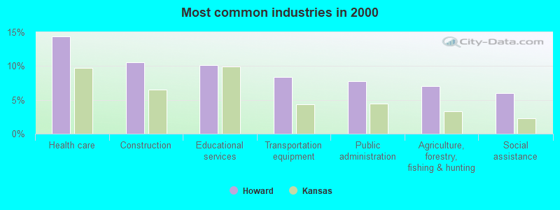
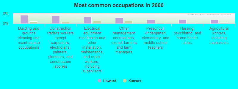
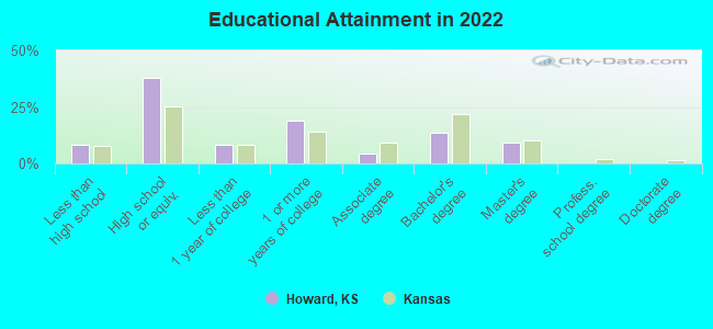
Building and grounds cleaning and maintenance occupations (6.7%)
Construction traders workers except carpenters, electricians, painters, plumbers, and construction laborers (6.3%)
Electrical equipment mechanics and other installation, maintenance, and repair workers, including supervisors (5.6%)
Other management occupations, except farmers and farm managers (4.9%)
Preschool, kindergarten, elementary, and middle school teachers (3.5%)
Nursing, psychiatric, and home health aides (3.5%)
Agricultural workers, including supervisors (3.2%)
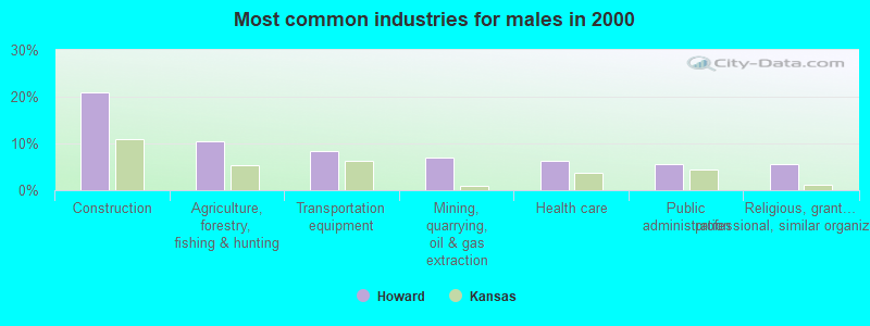
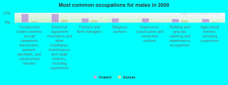
Construction traders workers except carpenters, electricians, painters, plumbers, and construction laborers (11.2%)
Electrical equipment mechanics and other installation, maintenance, and repair workers, including supervisors (11.2%)
Farmers and farm managers (5.6%)
Religious workers (5.6%)
Supervisors, construction and extraction workers (5.6%)
Building and grounds cleaning and maintenance occupations (4.9%)
Agricultural workers, including supervisors (4.9%)
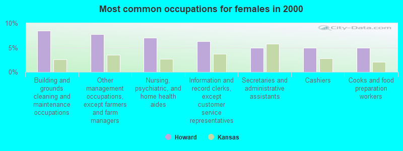
Building and grounds cleaning and maintenance occupations (8.5%)
Other management occupations, except farmers and farm managers (7.7%)
Nursing, psychiatric, and home health aides (7.0%)
Information and record clerks, except customer service representatives (6.3%)
Secretaries and administrative assistants (4.9%)
Cashiers (4.9%)
Cooks and food preparation workers (4.9%)
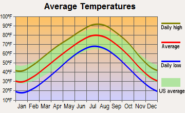
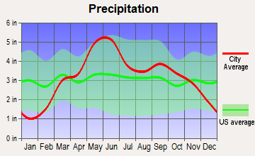
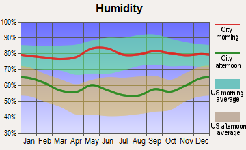
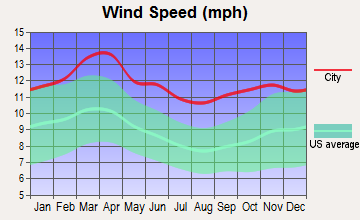
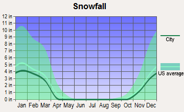
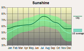
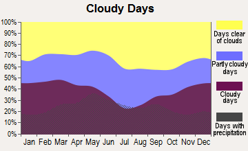
Average climate in Howard, Kansas
Based on data reported by over 4,000 weather stations
Tornado activity:
Howard-area historical tornado activity is near Kansas state average. It is 82% greater than the overall U.S. average.
On 5/25/1955, a category F5 (max. wind speeds 261-318 mph) tornado 26.8 miles away from the Howard city center killed 80 peopleand injured 273 peopleand causedbetween $50,000 and $500,000 in damages.
On 4/26/1991, a category F5 tornado 44.7 miles away from the city center killed 17 peopleand injured 225 peopleand causedbetween $50,000,000 and $500,000,000 in damages.
Earthquake activity:
Howard-area historical earthquake activity is significantly above Kansas state average. It is 777% greater than the overall U.S. average.
On 9/3/2016 at 12:02:44, a magnitude 5.8 (5.8 MW, Depth: 3.5 mi, Class: Moderate, Intensity: VI - VII) earthquake occurred 81.0 miles away from the city center On 11/6/2011 at 03:53:10, a magnitude 5.7 (5.7 MW, Depth: 3.2 mi) earthquake occurred 136.8 miles away from the city center On 11/12/2014 at 21:40:00, a magnitude 4.9 (4.9 MW, Depth: 2.5 mi, Class: Light, Intensity: IV - V) earthquake occurred 75.9 miles away from Howard center On 11/7/2016 at 01:44:24, a magnitude 5.0 (5.0 MW, Depth: 2.8 mi) earthquake occurred 106.5 miles away from Howard center On 2/13/2016 at 17:07:06, a magnitude 5.1 (5.1 MW, Depth: 5.2 mi) earthquake occurred 151.2 miles away from the city center On 11/30/2015 at 09:49:12, a magnitude 4.7 (4.7 MW, Depth: 3.5 mi) earthquake occurred 110.7 miles away from the city center Magnitude types: moment magnitude (MW)
Natural disasters:
The number of natural disasters in Elk County (16) is near the US average (15). Major Disasters (Presidential) Declared: 12 Emergencies Declared: 2
Causes of natural disasters: Floods: 10, Storms: 9, Tornadoes: 6, Winds: 5, Winter Storms: 4, Heavy Rain: 1, Hurricane: 1, Ice Storm: 1, Landslide: 1, Mudslide: 1, Snow: 1, Snowstorm: 1, Other: 1 (Note: some incidents may be assigned to more than one category).
Hospitals and medical centers in Howard:
HOWARD TWILIGHT MANOR (849 E WASHINGTON STREET)
Other hospitals and medical centers near Howard:
ELK MANOR HOME (Nursing Home, about 8 miles away; MOLINE, KS)
Colleges/universities with over 2000 students nearest to Howard:
Butler Community College (about 42 miles; El Dorado, KS; Full-time enrollment: 6,676)
Cowley County Community College (about 52 miles; Arkansas City, KS; FT enrollment: 3,173)
Wichita Area Technical College (about 57 miles; Wichita, KS; FT enrollment: 2,220)
Allen County Community College (about 58 miles; Iola, KS; FT enrollment: 2,089)
Wichita State University (about 60 miles; Wichita, KS; FT enrollment: 11,743)
Wichita Technical Institute (about 63 miles; Wichita, KS; FT enrollment: 2,015)
Friends University (about 63 miles; Wichita, KS; FT enrollment: 2,024)
Public high school in Howard:
WEST ELK SCHOOLS (Location: 1199 STATE HIGHWAY 99, Grades: PK-12)
Library in Howard:
HOWARD CITY LIBRARY (Operating income: $18,264; Location: 124 S. WABASH; 10,506 books; 20 e-books; 180 audio materials; 291 video materials; 30 state licensed databases; 15 print serial subscriptions)
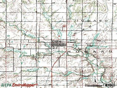
Notable locations in Howard: Elk County Sheriff's Office Jail (A), Howard Police Department (B), Elk County Courthouse (C), Elk County Sheriff's Office (D), Howard Fire Department (E), Elk County Emergency Medical Services (F), Elk County Health Department (G), Benson Historical Museum (H), Howard City Library (I), Howard City Hall (J), Elk County Rural Fire District Howard Fire Department (K). Display/hide their locations on the map
Churches in Howard include: First Baptist Church (A), Flint Hills Assembly of God Church (B), Howard United Methodist Church (C). Display/hide their locations on the map
Court: Elk-County - Clerk Of District Court (Howard Courthouse).
Elk County has a predicted average indoor radon screening level between 2 and 4 pCi/L (pico curies per liter) - Moderate Potential
Drinking water stations with addresses in Howard and their reported violations in the past:
HOWARD, CITY OF (Population served: 649, Surface water):
Past health violations:
MCL, Average - Between JAN-2012 and MAR-2012, Contaminant: Total Haloacetic Acids (HAA5). Follow-up actions: St Compliance achieved (JUN-30-2012), St Public Notif requested (AUG-05-2012), St Violation/Reminder Notice (AUG-05-2012)
MCL, Average - Between JUL-2006 and SEP-2006, Contaminant: TTHM. Follow-up actions: St BCA signed (AUG-24-2006), St Public Notif requested (OCT-14-2006), St Violation/Reminder Notice (OCT-14-2006), St Public Notif received (OCT-27-2006), St Compliance achieved (NOV-27-2006)
MCL, Average - Between APR-2006 and JUN-2006, Contaminant: TTHM. Follow-up actions: St Public Notif requested (JUL-28-2006), St Violation/Reminder Notice (JUL-28-2006), St Public Notif received (AUG-23-2006), St BCA signed (AUG-24-2006), St Compliance achieved (NOV-27-2006)
MCL, Average - Between APR-2006 and JUN-2006, Contaminant: Total Haloacetic Acids (HAA5). Follow-up actions: St Public Notif requested (JUL-28-2006), St Violation/Reminder Notice (JUL-28-2006), St Compliance achieved (AUG-11-2006), St Public Notif received (AUG-23-2006), St BCA signed (AUG-24-2006)
MCL, Average - Between JAN-2006 and MAR-2006, Contaminant: Total Haloacetic Acids (HAA5). Follow-up actions: St Public Notif requested (APR-24-2006), St Violation/Reminder Notice (APR-24-2006), St Public Notif received (MAY-17-2006), St Compliance achieved (AUG-11-2006), St BCA signed (AUG-24-2006)
MCL, Average - Between JAN-2006 and MAR-2006, Contaminant: TTHM. Follow-up actions: St Public Notif requested (APR-24-2006), St Violation/Reminder Notice (APR-24-2006), St Public Notif received (MAY-17-2006), St BCA signed (AUG-24-2006), St Compliance achieved (NOV-27-2006)
6 other older health violations
Past monitoring violations:
Treatment Technique Precursor Removal - Between JAN-2012 and MAR-2012, Contaminant: CARBON, TOTAL. Follow-up actions: St Compliance achieved (JUN-30-2012), St Public Notif requested (AUG-19-2012), St Violation/Reminder Notice (AUG-19-2012), St Public Notif received (SEP-10-2012)
Treatment Technique Precursor Removal - Between OCT-2011 and DEC-2011, Contaminant: CARBON, TOTAL. Follow-up actions: St Public Notif requested (FEB-17-2012), St Violation/Reminder Notice (FEB-17-2012), St Public Notif received (MAR-27-2012), St Compliance achieved (JUN-30-2012)
Treatment Technique Precursor Removal - Between JUL-2011 and SEP-2011, Contaminant: CARBON, TOTAL. Follow-up actions: St Public Notif requested (DEC-23-2011), St Violation/Reminder Notice (DEC-23-2011), St Public Notif received (FEB-02-2012), St Compliance achieved (JUN-30-2012)
Treatment Technique Precursor Removal - Between APR-2011 and JUN-2011, Contaminant: CARBON, TOTAL. Follow-up actions: St Public Notif requested (AUG-01-2011), St Violation/Reminder Notice (AUG-01-2011), St Public Notif received (AUG-29-2011), St Compliance achieved (JUN-30-2012)
Failure Submit IDSE/Subpart V Plan Rpt - In JUL-02-2010, Contaminant: DBP STAGE 2. Follow-up actions: Fed FAO issued (DEC-20-2010), Fed Public Notif requested (DEC-20-2010), Fed Compliance achieved (NOV-21-2011)
2 other older monitoring violations
Drinking water stations with addresses in Howard that have no violations reported:
ELK CO RWD 2 (Population served: 206,Primary Water Source Type: Purch surface water)
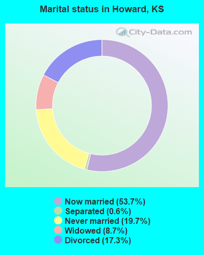
Average household size:
This city:
2.0 people
Kansas:
2.5 people
Percentage of family households:
This city:
55.3%
Whole state:
66.0%
Percentage of households with unmarried partners:
This city:
5.3%
Whole state:
5.8%
No gay or lesbian households reported
34 people in nursing facilities/skilled-nursing facilities in 2010
6 people in local jails and other municipal confinement facilities in 2010
44 people in nursing homes in 2000
7 people in local jails and other confinement facilities (including police lockups) in 2000
Banks with branches in Howard (2011 data):
The First National Bank of Howard: The First National Bank Of Howard at 101 S Wabash St, branch established on 1885/01/01. Info updated 2010/06/01: Bank assets: $8.6 mil, Deposits: $6.9 mil, local headquarters, positive income, Agricultural Specialization, 1 total offices, Holding Company: First Howard Bankshares, Inc.
The Howard State Bank, Howard, Kansas: at 100 South Wabash Street, branch established on 1877/08/30. Info updated 2008/01/23: Bank assets: $44.5 mil, Deposits: $39.9 mil, local headquarters, positive income, Agricultural Specialization, 4 total offices, Holding Company: Elk County Bankshares, Inc.
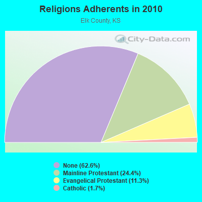
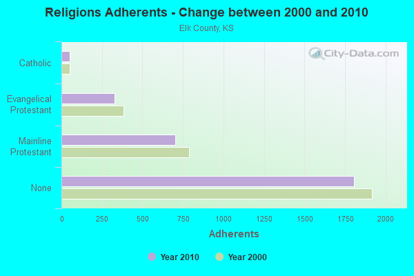
Religion statistics for Howard, KS (based on Elk County data)
Religion
Adherents
Congregations
Mainline Protestant
702
8
Evangelical Protestant
327
5
Catholic
50
1
Other
-
-
None
1,803
-
Source: Clifford Grammich, Kirk Hadaway, Richard Houseal, Dale E.Jones, Alexei Krindatch, Richie Stanley and Richard H.Taylor. 2012. 2010 U.S.Religion Census: Religious Congregations & Membership Study. Association of Statisticians of American Religious Bodies. Jones, Dale E., et al. 2002. Congregations and Membership in the United States 2000. Nashville, TN: Glenmary Research Center. Graphs represent county-level data
Sheriff Annex At Court House (Lat: 37.468917 Lon: -96.261667), Call Sign: KJE973, Licensee ID: L00027674, Assigned Frequencies: 39.5800 MHz, Grant Date: 02/08/2002, Expiration Date: 02/09/2012, Cancellation Date: 04/14/2012, Registrant: County Of Elk, 100 Cedar St Courthouse, Howard, KS 67349, Phone: (316) 374-2108
305 S Cherry St (Lat: 37.468361 Lon: -96.271667), Type: Tower, Structure height: 9 m, Call Sign: WPRL559, Assigned Frequencies: 173.203 MHz, Grant Date: 10/30/2015, Expiration Date: 11/09/2025, Certifier: Carolyn Howell, Registrant: City Of Howard, 110 North Pine Street, Howard, KS 67349, Phone: (620) 374-2202, Fax: (620) 374-3060, Email:
FCC Registered Microwave Towers:
1
Howard MW, Howard Mw (Lat: 37.417750 Lon: -96.273778), Type: Tower, Structure height: 106 m, Call Sign: WQJG577, Assigned Frequencies: 6226.89 MHz, 6197.24 MHz, 6315.84 MHz, Grant Date: 08/07/2018, Expiration Date: 09/02/2028, Cancellation Date: 03/19/2019, Certifier: Richard A Ruhl, Registrant: Lukas, Lafuria, Gutierrez & Sachs, LLP, 8300 Greensboro Drive, Suite 1200, Tysons, VA 22102, Phone: (703) 584-8665, Fax: (703) 584-8696, Email:
FCC Registered Amateur Radio Licenses:
2
Call Sign: W0WTF, Licensee ID: L00869722, Grant Date: 05/27/2004, Expiration Date: 08/19/2014, Cancellation Date: 08/20/2016, Certifier: Dennis Crisp, Registrant: Dennis Crisp, 643 E Jefferson, Howard, KS 67349
Call Sign: WD0DSN, Grant Date: 01/21/1995, Expiration Date: 01/21/2005, Cancellation Date: 01/23/2007, Registrant: Robert L Vinette, 103 S Pennsylvania Box 126, Howard, KS 67349
FAA Registered Aircraft:
3
Aircraft: BUCKEYE INDUSTRIES INC BUCKEYE DREAM (Category: Land, Seats: 2, Weight: Up to 12,499 Pounds), Engine: ROTAX 582SER (65 HP) (2 Cycle) N-Number: 1651L, N1651L, N-1651L, Serial Number: 4561, Year manufactured: 1999, Airworthiness Date: 10/30/2007, Certificate Issue Date: 05/04/2007 Registrant (Individual): Joe R Hutchison, 1177 Killdeer, Howard, KS 67349
Aircraft: CESSNA 182A (Category: Land, Seats: 4, Weight: Up to 12,499 Pounds, Speed: 119 mph), Engine: CONT MOTOR O-470 SERIES (230 HP) (Reciprocating) N-Number: 3727D, N3727D, N-3727D, Serial Number: 34427, Year manufactured: 1957, Airworthiness Date: 06/21/1957, Certificate Issue Date: 03/13/1986 Registrant (Individual): Ralph R Roggow, 1535 Killdeer, Howard, KS 67349, Other Owners: Jo Ann Roggow
Aircraft: SIXCHUTER SR7 (Category: Land, Seats: 2, Weight: Up to 12,499 Pounds), Engine: ROTAX 582UL DCDI (65 HP) (2 Cycle) N-Number: 80114, N80114, N-80114, Serial Number: SR-2756, Year manufactured: 2002, Airworthiness Date: 10/30/2007, Certificate Issue Date: 09/28/2006 Registrant (Individual): Jeffrey K Frieden, 1948 Limestone, Howard, KS 67349
2002 - 2018 National Fire Incident Reporting System (NFIRS) incidents
According to the data from the years 2002 - 2018 the average number of fires per year is 20. The highest number of reported fire incidents - 43 took place in 2014, and the least - 3 in 2004. The data has a rising trend.
When looking into fire subcategories, the most incidents belonged to: Outside Fires (69.5%), and Structure Fires (22.9%).
Fire incident types reported to NFIRS in Howard, KS


 Recent articles from our blog. Our writers, many of them Ph.D. graduates or candidates, create easy-to-read articles on a wide variety of topics.

 (60.8 miles
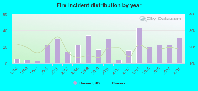 According to the data from the years 2002 - 2018 the average number of fires per year is 20. The highest number of reported fire incidents - 43 took place in 2014, and the least - 3 in 2004. The data has a rising trend.
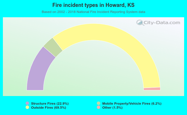 When looking into fire subcategories, the most incidents belonged to: Outside Fires (69.5%), and Structure Fires (22.9%).