Georgia, Vermont
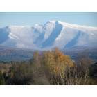
Georgia: West Face of Mt.Mansfield from Silver Lake Rd., Georgia, Vermont
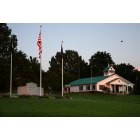
Georgia: Georgia Vermont Town Offices

Georgia
- add
your
Submit your own pictures of this town and show them to the world
- OSM Map
- Google Map
- MSN Map
Population change since 2000: +3.2%
 |
| Males: 2,274 | |
| Females: 2,241 |
| Median resident age: | 39.4 years |
| Vermont median age: | 45.8 years |
Zip codes: 05478.
| Georgia: | $95,692 |
| VT: | $73,991 |
Estimated per capita income in 2022: $42,228 (it was $20,888 in 2000)
Georgia town income, earnings, and wages data
Estimated median house or condo value in 2022: $367,790 (it was $124,800 in 2000)
| Georgia: | $367,790 |
| VT: | $304,700 |
Mean prices in 2022: all housing units: $315,920; detached houses: $330,047; townhouses or other attached units: $317,666; in 2-unit structures: $273,445; in 3-to-4-unit structures: $369,333; in 5-or-more-unit structures: $248,038; mobile homes: $115,386
Detailed information about poverty and poor residents in Georgia, VT


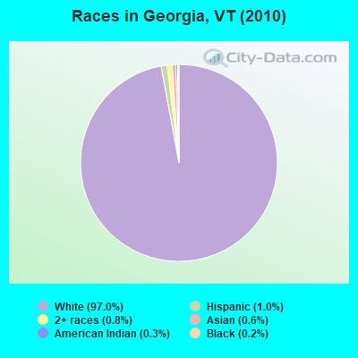
- 4,37997.0%White alone
- 441.0%Hispanic
- 380.8%Two or more races
- 280.6%Asian alone
- 130.3%American Indian alone
- 90.2%Black alone
- 20.04%Native Hawaiian and Other
Pacific Islander alone - 20.04%Other race alone
Races in Georgia detailed stats: ancestries, foreign born residents, place of birth
According to our research of Vermont and other state lists, there were 3 registered sex offenders living in Georgia, Vermont as of June 07, 2024.
The ratio of all residents to sex offenders in Georgia is 1,505 to 1.
The ratio of registered sex offenders to all residents in this city is much lower than the state average.
 Recent articles from our blog. Our writers, many of them Ph.D. graduates or candidates, create easy-to-read articles on a wide variety of topics.
Ancestries: French (18.1%), Irish (17.0%), English (14.8%), French Canadian (12.3%), United States (9.9%), German (8.5%).
Current Local Time: EST time zone
Land area: 39.5 square miles.
Population density: 114 people per square mile (very low).
145 residents are foreign born (1.8% North America, 0.9% Europe, 0.4% Asia).
| This town: | 3.3% |
| Vermont: | 3.8% |
| Georgia town: | 1.6% ($1,977) |
| Vermont: | 2.0% ($2,196) |
Nearest city with pop. 50,000+: Schenectady, NY  (138.3 miles , pop. 61,821).
Nearest city with pop. 200,000+: Boston, MA (194.0 miles , pop. 589,141).
Nearest city with pop. 1,000,000+: Bronx, NY (270.3 miles , pop. 1,332,650).
Nearest cities:
), Latitude: 44.71 N, Longitude: 73.11 W
Area code commonly used in this area: 802
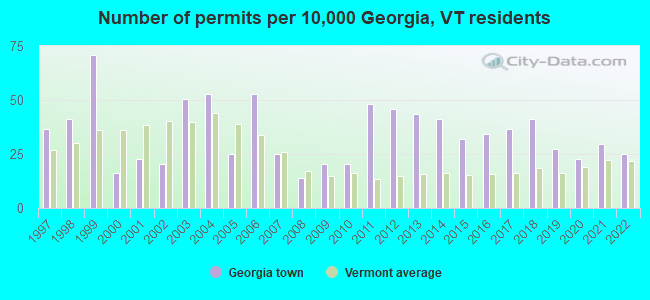
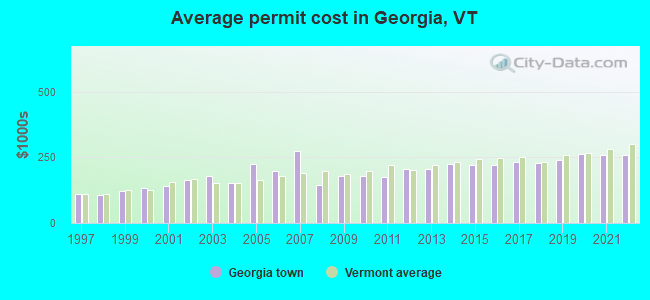
Single-family new house construction building permits:
- 2022: 11 buildings, average cost: $261,100
- 2021: 13 buildings, average cost: $259,600
- 2020: 10 buildings, average cost: $265,300
- 2019: 12 buildings, average cost: $240,400
- 2018: 18 buildings, average cost: $229,000
- 2017: 16 buildings, average cost: $230,700
- 2016: 15 buildings, average cost: $222,800
- 2015: 14 buildings, average cost: $221,600
- 2014: 18 buildings, average cost: $224,300
- 2013: 19 buildings, average cost: $205,000
- 2012: 20 buildings, average cost: $205,000
- 2011: 21 buildings, average cost: $175,000
- 2010: 9 buildings, average cost: $178,900
- 2009: 9 buildings, average cost: $178,900
- 2008: 6 buildings, average cost: $145,000
- 2007: 11 buildings, average cost: $272,700
- 2006: 23 buildings, average cost: $198,000
- 2005: 11 buildings, average cost: $225,000
- 2004: 23 buildings, average cost: $152,000
- 2003: 22 buildings, average cost: $178,900
- 2002: 9 buildings, average cost: $165,000
- 2001: 10 buildings, average cost: $139,700
- 2000: 7 buildings, average cost: $131,500
- 1999: 31 buildings, average cost: $122,900
- 1998: 18 buildings, average cost: $106,000
- 1997: 16 buildings, average cost: $111,800
| Here: | 1.5% |
| Vermont: | 2.0% |
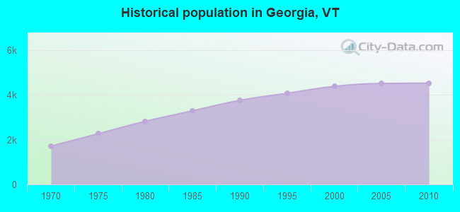
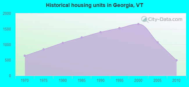
Population change in the 1990s: +543 (+14.2%).
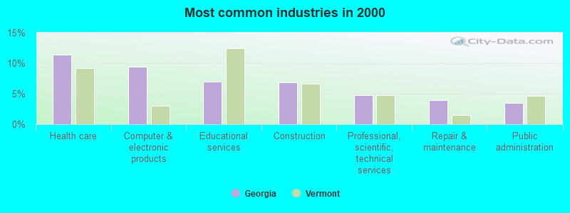
- Health care (11.4%)
- Computer & electronic products (9.4%)
- Educational services (7.0%)
- Construction (6.9%)
- Professional, scientific, technical services (4.8%)
- Repair & maintenance (3.9%)
- Public administration (3.5%)
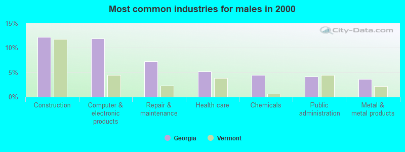
- Construction (12.2%)
- Computer & electronic products (11.9%)
- Repair & maintenance (7.3%)
- Health care (5.2%)
- Chemicals (4.5%)
- Public administration (4.1%)
- Metal & metal products (3.6%)
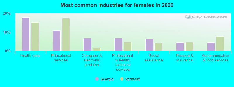
- Health care (17.8%)
- Educational services (10.9%)
- Computer & electronic products (6.8%)
- Professional, scientific, technical services (6.8%)
- Social assistance (6.3%)
- Finance & insurance (4.5%)
- Accommodation & food services (4.5%)
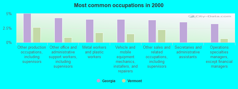
- Other production occupations, including supervisors (5.0%)
- Other office and administrative support workers, including supervisors (4.3%)
- Metal workers and plastic workers (4.0%)
- Vehicle and mobile equipment mechanics, installers, and repairers (4.0%)
- Other sales and related occupations, including supervisors (3.9%)
- Secretaries and administrative assistants (3.5%)
- Operations specialties managers, except financial managers (3.2%)
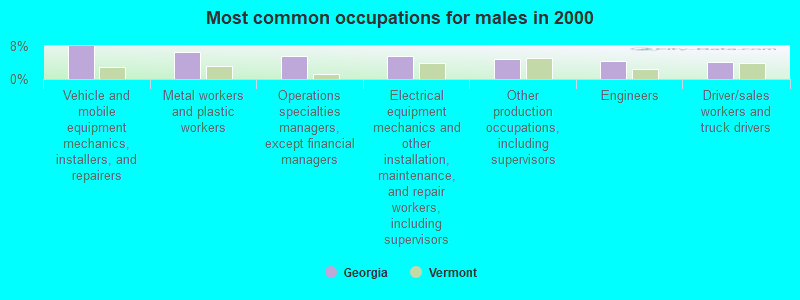
- Vehicle and mobile equipment mechanics, installers, and repairers (7.9%)
- Metal workers and plastic workers (6.6%)
- Operations specialties managers, except financial managers (5.6%)
- Electrical equipment mechanics and other installation, maintenance, and repair workers, including supervisors (5.5%)
- Other production occupations, including supervisors (4.9%)
- Engineers (4.3%)
- Driver/sales workers and truck drivers (4.2%)
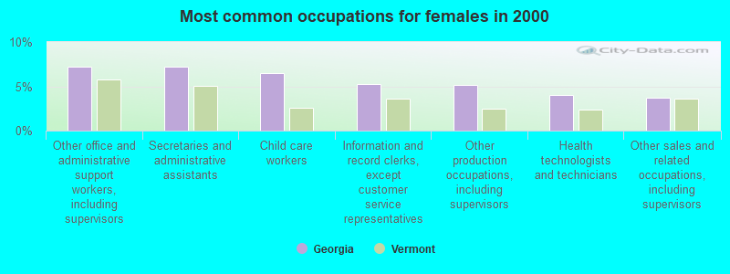
- Other office and administrative support workers, including supervisors (7.3%)
- Secretaries and administrative assistants (7.2%)
- Child care workers (6.5%)
- Information and record clerks, except customer service representatives (5.3%)
- Other production occupations, including supervisors (5.2%)
- Health technologists and technicians (4.0%)
- Other sales and related occupations, including supervisors (3.7%)
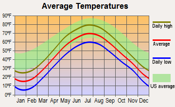
Average climate in Georgia, Vermont
Based on data reported by over 4,000 weather stations


(lower is better)
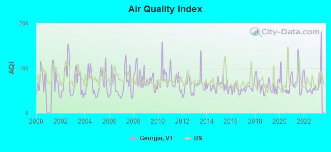
Air Quality Index (AQI) level in 2022 was 56.4. This is better than average.
| City: | 56.4 |
| U.S.: | 72.6 |
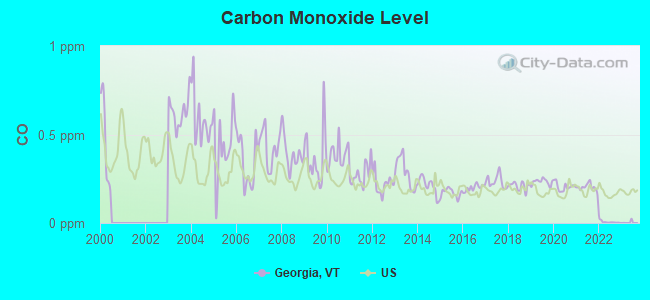
Carbon Monoxide (CO) [ppm] level in 2022 was 0.00585. This is significantly better than average. Closest monitor was 17.0 miles away from the city center.
| City: | 0.00585 |
| U.S.: | 0.25132 |
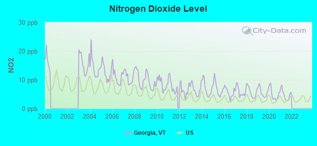
Nitrogen Dioxide (NO2) [ppb] level in 2021 was 4.81. This is about average. Closest monitor was 17.0 miles away from the city center.
| City: | 4.81 |
| U.S.: | 5.11 |
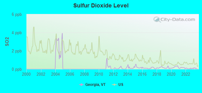
Sulfur Dioxide (SO2) [ppb] level in 2022 was 0.0619. This is significantly better than average. Closest monitor was 17.2 miles away from the city center.
| City: | 0.0619 |
| U.S.: | 1.5147 |
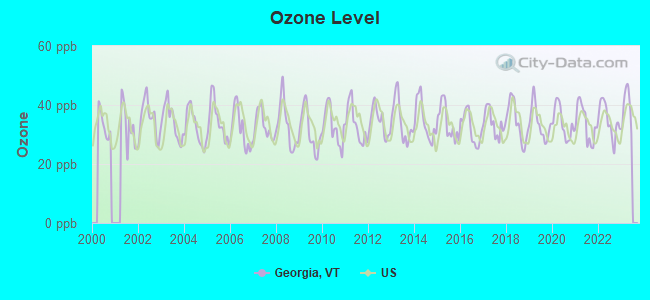
Ozone [ppb] level in 2022 was 34.8. This is about average. Closest monitor was 17.0 miles away from the city center.
| City: | 34.8 |
| U.S.: | 33.3 |
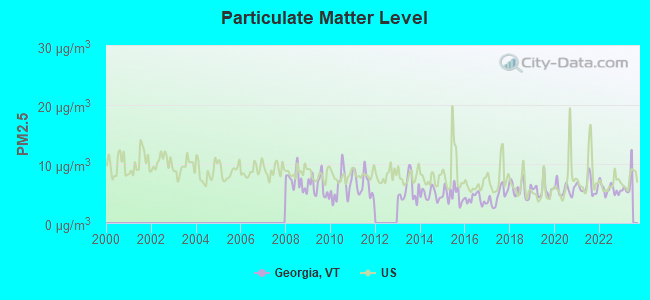
Particulate Matter (PM2.5) [µg/m3] level in 2022 was 5.73. This is significantly better than average. Closest monitor was 16.9 miles away from the city center.
| City: | 5.73 |
| U.S.: | 8.11 |
Earthquake activity:
Georgia-area historical earthquake activity is significantly above Vermont state average. It is 72% smaller than the overall U.S. average.On 4/20/2002 at 10:50:47, a magnitude 5.3 (5.3 ML, Depth: 3.0 mi, Class: Moderate, Intensity: VI - VII) earthquake occurred 32.1 miles away from the city center
On 4/20/2002 at 10:50:47, a magnitude 5.2 (5.2 MB, 4.2 MS, 5.2 MW, 5.0 MW) earthquake occurred 33.8 miles away from the city center
On 10/7/1983 at 10:18:46, a magnitude 5.3 (5.1 MB, 5.3 LG, 5.1 ML) earthquake occurred 80.5 miles away from Georgia center
On 1/19/1982 at 00:14:42, a magnitude 4.7 (4.5 MB, 4.7 MD, 4.5 LG, Class: Light, Intensity: IV - V) earthquake occurred 112.6 miles away from Georgia center
On 10/16/2012 at 23:12:25, a magnitude 4.7 (4.7 ML, Depth: 10.0 mi) earthquake occurred 144.2 miles away from Georgia center
On 4/20/2002 at 11:04:42, a magnitude 3.7 (3.7 ML, Depth: 3.1 mi, Class: Light, Intensity: II - III) earthquake occurred 32.5 miles away from the city center
Magnitude types: regional Lg-wave magnitude (LG), body-wave magnitude (MB), duration magnitude (MD), local magnitude (ML), surface-wave magnitude (MS), moment magnitude (MW)
Natural disasters:
The number of natural disasters in Franklin County (23) is greater than the US average (15).Major Disasters (Presidential) Declared: 19
Emergencies Declared: 1
Causes of natural disasters: Floods: 16, Storms: 15, Winds: 2, Winter Storms: 2, Heavy Rain: 1, Hurricane: 1, Ice Storm: 1, Landslide: 1, Snow: 1, Tropical Storm: 1, Other: 1 (Note: some incidents may be assigned to more than one category).
Hospitals and medical centers near Georgia:
- FRANKLIN COUNTY REHAB CENTER LLC (Nursing Home, about 5 miles away; ST ALBANS, VT)
- NORTHWESTERN MEDICAL CENTER INC Acute Care Hospitals (about 7 miles away; SAINT ALBANS, VT)
- FLETCHER ALLEN HEALTHCARE - ST. ALBANS SATELLITE (Dialysis Facility, about 7 miles away; SAINT ALBANS, VT)
- REDSTONE VILLA (Nursing Home, about 7 miles away; ST ALBANS, VT)
- SAINT ALBANS HEALTHCARE AND REHABILITATION CENTER (Nursing Home, about 9 miles away; SAINT ALBANS, VT)
- VISITING NURSE ASSOCIATION (Home Health Center, about 14 miles away; COLCHESTER, VT)
- GREEN MOUNTAIN NURSING AND REHABILITATION (Nursing Home, about 15 miles away; COLCHESTER, VT)
Amtrak stations near Georgia:
- 7 miles: ST. ALBANS (40 FEDERAL ST.) . Services: ticket office, partially wheelchair accessible, enclosed waiting area, public restrooms, public payphones, full-service food facilities, ATM, free short-term parking, free long-term parking, call for car rental service.
- 16 miles: BURLINGTON-ESSEX JUNCTION (ESSEX JUNCTION, 29 RAILROAD AVE.) . Services: ticket office, partially wheelchair accessible, enclosed waiting area, public restrooms, public payphones, vending machines, ATM, free short-term parking, free long-term parking, call for car rental service, call for taxi service, public transit connection.
- 17 miles: PLATTSBURGH (BRIDGE ST.) . Services: enclosed waiting area, public restrooms, public payphones, free short-term parking, free long-term parking, call for car rental service, call for taxi service.
Colleges/universities with over 2000 students nearest to Georgia:
- Saint Michael's College (about 16 miles; Colchester, VT; Full-time enrollment: 2,336)
- Community College of Vermont (about 16 miles; Winooski, VT; FT enrollment: 3,394)
- University of Vermont (about 17 miles; Burlington, VT; FT enrollment: 11,566)
- Champlain College (about 18 miles; Burlington, VT; FT enrollment: 2,623)
- SUNY College at Plattsburgh (about 18 miles; Plattsburgh, NY; FT enrollment: 5,934)
- Norwich University (about 46 miles; Northfield, VT; FT enrollment: 4,221)
- Middlebury College (about 49 miles; Middlebury, VT; FT enrollment: 3,077)
Points of interest:
Notable locations in Georgia: Homestead Campgrounds (A), Burtland Farms (B), Georgia Volunteer Fire Department (C). Display/hide their locations on the map
Cemeteries: Evarts Cemetery (1), Hope Cemetery (2), Waller Cemetery (3), Torrey Cemetery (4), Sabin Cemetery (5), Loomis Cemetery (6), Hyde Cemetery (7). Display/hide their locations on the map
Lake: Lost Lake (A). Display/hide its location on the map
Streams, rivers, and creeks: Rugg Brook (A), Mill River (B), Beaver Meadow Brook (C). Display/hide their locations on the map
Birthplace of: George J. Stannard - Union Army general, Joel Dewey - Union Army general.
Drinking water stations with addresses in Georgia and their reported violations in the past:
SOUTH GEORGIA FIRE DISTRICT (Address: 73 SUNSET CIRCLE , Population served: 460, Groundwater):Past health violations:FOUNDATIONS TO SUCCESS DAYCARE LLC (Population served: 46, Groundwater):
- MCL, Monthly (TCR) - In MAY-2009, Contaminant: Coliform. Follow-up actions: St Formal NOV issued (MAY-15-2009), St Public Notif requested (MAY-15-2009), St Compliance achieved (AUG-09-2010)
Past monitoring violations:
- One routine major monitoring violation
- 21 regular monitoring violations
| This town: | 2.8 people |
| Vermont: | 2.3 people |
| This town: | 81.2% |
| Whole state: | 62.5% |
| This town: | 7.8% |
| Whole state: | 9.2% |
Likely homosexual households (counted as self-reported same-sex unmarried-partner households)
- Lesbian couples: 0.6% of all households
- Gay men: 0.3% of all households
| This town: | 3.8% |
| Whole state: | 9.4% |
| This town: | 1.2% |
| Whole state: | 3.6% |
For population 15 years and over in Georgia:
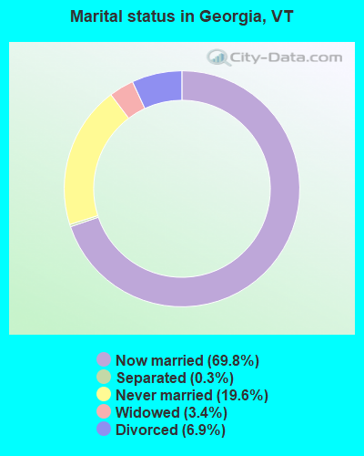
- Never married: 19.6%
- Now married: 69.8%
- Separated: 0.3%
- Widowed: 3.4%
- Divorced: 6.9%
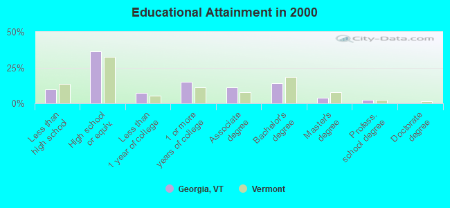
For population 25 years and over in Georgia:
- High school or higher: 90.5%
- Bachelor's degree or higher: 20.5%
- Graduate or professional degree: 6.4%
- Unemployed: 1.5%
- Mean travel time to work (commute): 24.8 minutes
| Here: | 9.7 |
| Vermont average: | 11.7 |
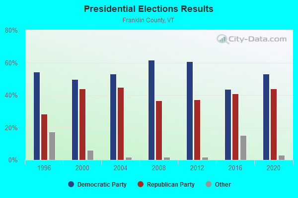
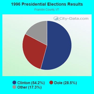
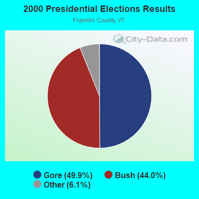
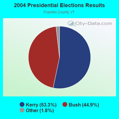
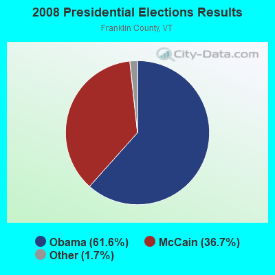
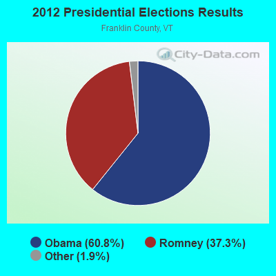
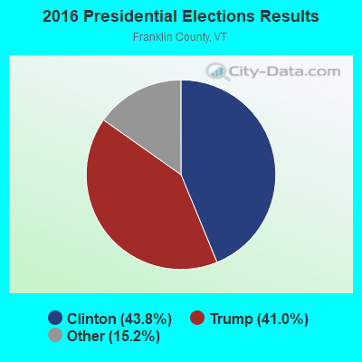
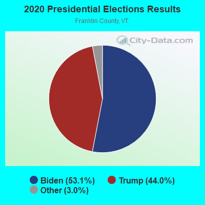
Graphs represent county-level data. Detailed 2008 Election Results
Religion statistics for Georgia, VT (based on Franklin County data)
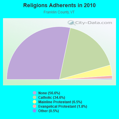
| Religion | Adherents | Congregations |
|---|---|---|
| Catholic | 16,526 | 15 |
| Mainline Protestant | 3,085 | 28 |
| Evangelical Protestant | 874 | 8 |
| Other | 216 | 3 |
| Orthodox | - | - |
| None | 27,045 | - |
Food Environment Statistics:
| This county: | 3.55 / 10,000 pop. |
| Vermont: | 3.84 / 10,000 pop. |
| This county: | 1.67 / 10,000 pop. |
| Vermont: | 1.95 / 10,000 pop. |
| Here: | 7.74 / 10,000 pop. |
| State: | 6.40 / 10,000 pop. |
| Franklin County: | 7.32 / 10,000 pop. |
| Vermont: | 11.52 / 10,000 pop. |
| Here: | 7.3% |
| State: | 6.8% |
| Here: | 26.4% |
| State: | 22.3% |
| This county: | 15.2% |
| Vermont: | 13.3% |
Strongest AM radio stations in Georgia:
- WCHP (760 AM; 35 kW; CHAMPLAIN, NY; Owner: CHAMPLAIN RADIO, INC.)
- WVMT (620 AM; 5 kW; BURLINGTON, VT; Owner: SISON BROADCASTING, INC.)
- WVAA (1390 AM; 5 kW; BURLINGTON, VT; Owner: RADIO VERMONT, KDR, LLC)
- WEAV (960 AM; 5 kW; PLATTSBURGH, NY; Owner: CLEAR CHANNEL BROADCASTING LICENSES, INC.)
- WTWK (1070 AM; daytime; 5 kW; PLATTSBURGH, NY; Owner: CHAMPLAIN COMMUNICATIONS CORPORATION)
- WICY (1490 AM; 50 kW; MALONE, NY; Owner: CARTIER COMMUNICATIONS INC.)
- WRSA (1420 AM; 1 kW; ST. ALBANS, VT)
- WDEV (550 AM; 5 kW; WATERBURY, VT; Owner: RADIO VERMONT, INC.)
- WGY (810 AM; 50 kW; SCHENECTADY, NY; Owner: CLEAR CHANNEL BROADCASTING LICENSES, INC.)
- WNNZ (640 AM; 50 kW; WESTFIELD, MA; Owner: CLEAR CHANNEL BROADCASTING LICENSES, INC.)
- WJOY (1230 AM; 1 kW; BURLINGTON, VT; Owner: HALL COMMUNICATIONS, INC.)
- WIRY (1340 AM; 1 kW; PLATTSBURGH, NY; Owner: HOMETOWN RADIO INC)
- WRKO (680 AM; 50 kW; BOSTON, MA; Owner: ENTERCOM BOSTON LICENSE, LLC)
Strongest FM radio stations in Georgia:
- WLFE-FM (102.3 FM; ST. ALBANS, VT; Owner: CHAMPLAIN COMMUNICATIONS CORP.)
- WEZF (92.9 FM; BURLINGTON, VT; Owner: CAPSTAR TX LIMITED PARTNERSHIP)
- WVPS (107.9 FM; BURLINGTON, VT; Owner: VERMONT PUBLIC RADIO)
- WLKC (103.3 FM; WATERBURY, VT; Owner: RADIO BROADCASTING SERVICES, INC.)
- WCVT (101.7 FM; STOWE, VT; Owner: RADIO VERMONT CLASSICS, L.L.C.)
- WCEL (91.9 FM; PLATTSBURGH, NY; Owner: WAMC)
- WNCS (104.7 FM; MONTPELIER, VT; Owner: MONTPELIER BROADCASTING, INC.)
- WCPV (101.3 FM; ESSEX, NY; Owner: CAPSTAR TX LIMITED PARTNERSHIP)
- WDEV-FM (96.1 FM; WARREN, VT; Owner: RADIO VERMONT, INC.)
- WBTZ (99.9 FM; PLATTSBURGH, NY; Owner: PLATTSBURGH BROADCASTING CORPORATION)
- WGLY-FM (91.5 FM; BOLTON, VT; Owner: CHRISTIAN MINISTRIES, INC.)
- WXLU (88.3 FM; PERU, NY; Owner: THE ST. LAWRENCE UNIVERSITY)
- WYUL (94.7 FM; CHATEAUGAY, NY; Owner: CARTIER COMMUNICATIONS INC.)
- WXZO (96.7 FM; WILLSBORO, NY; Owner: CAPSTAR TX LIMITED PARTNERSHIP)
- WIZN (106.7 FM; VERGENNES, VT; Owner: BURLINGTON BROADCASTERS, INC.)
- WXXX (95.5 FM; SOUTH BURLINGTON, VT; Owner: SISON BROADCASTING, INC.)
- W207AX (89.3 FM; BURLINGTON, VT; Owner: FAMILY STATIONS, INC.)
- WOKO (98.9 FM; BURLINGTON, VT; Owner: HALL COMMUNICATIONS, INC.)
- WKOL (105.1 FM; PLATTSBURGH, NY; Owner: HALL COMMUNICATIONS, INC.)
TV broadcast stations around Georgia:
- WPTZ (Channel 5; NORTH POLE, NY; Owner: HEARST-ARGYLE STATIONS, INC.)
- W52CD (Channel 52; ST. ALBANS, VT; Owner: VERMONT LOW POWER TV, LP)
- W16AL (Channel 16; BURLINGTON, VT; Owner: TRINITY BROADCASTING NETWORK)
- WVNY (Channel 22; BURLINGTON, VT; Owner: C-22 FCC LICENSEE SUBSIDIARY, LLC)
- National Bridge Inventory (NBI) Statistics
- 15Number of bridges
- 272ft / 83.4mTotal length
- $2,723,000Total costs
- 137,893Total average daily traffic
- 15,347Total average daily truck traffic
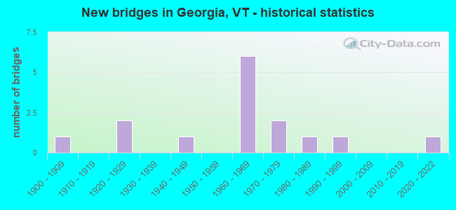
- New bridges - historical statistics
- 11900-1909
- 21920-1929
- 11940-1949
- 61960-1969
- 21970-1979
- 11980-1989
- 11990-1999
- 12020-2022
FCC Registered Broadcast Land Mobile Towers:
1- Lat: 44.697333 Lon: -73.097667, Call Sign: WQKK836,
Assigned Frequencies: 451.612 MHz, 456.612 MHz, 451.762 MHz, 456.762 MHz, Grant Date: 06/18/2019, Expiration Date: 06/29/2029, Cancellation Date: 10/25/2021, Certifier: Peggy S Fisk, Registrant: Pbm Nutritionals, LLC, 147 Industrial Park Road, Georgia, VT 05628-2109, Phone: (802) 528-8747, Fax: (802) 524-6457, Email:
FCC Registered Microwave Towers:
1- STATION, Georgia Substation (Lat: 44.714194 Lon: -73.154000), Structure height: 19.2 m, Call Sign: WBH561,
Assigned Frequencies: 2139.60 MHz, Grant Date: 05/23/1991, Expiration Date: 05/23/1996, Phone: (802) 773-9161
FCC Registered Amateur Radio Licenses:
5- Call Sign: K0ALA, Licensee ID: L00266195, Grant Date: 12/18/1997, Expiration Date: 12/18/2007, Cancellation Date: 05/23/2004, Registrant: Bruce E Alspach, 927 Georgia Shore Road, Georgia, VT 05468-3461
- Call Sign: N1QMY, Licensee ID: L00775442, Grant Date: 09/24/2013, Expiration Date: 12/19/2023, Certifier: Steven L Lapierre, Registrant: Steven L Lapierre, 181 Oakland Station Rd, Georgia, VT 05478
- Call Sign: KB1IGZ, Licensee ID: L00508934, Grant Date: 04/29/2002, Expiration Date: 04/29/2012, Cancellation Date: 05/24/2002, Certifier: Matthew G Bean, Registrant: Matthew G Bean, Georgia, VT 05468-2151
- Call Sign: KB1KJQ, Licensee ID: L00754318, Grant Date: 07/18/2023, Expiration Date: 10/14/2033, Certifier: Derek T Adams, Registrant: Derek T Adams, 184b Ledgewood Ln, Georgia, VT 05468-8428
- Call Sign: KB1MYD, Licensee ID: L00550206, Grant Date: 01/12/2016, Expiration Date: 01/12/2026, Certifier: Zachary N Borst, Registrant: Zachary N Borst, 126b Rock Maple Dr, Georgia, VT 05454
FAA Registered Aircraft:
1- Aircraft: MAULE M-4-210 (Category: Land, Seats: 4, Weight: Up to 12,499 Pounds, Speed: 108 mph), Engine: CONT MOTOR IO-360 SER (300 HP) (Reciprocating)
N-Number: 4624T, N4624T, N-4624T, Serial Number: 1026, Year manufactured: 1965, Airworthiness Date: 06/11/1965, Certificate Issue Date: 06/20/2018
Registrant (Individual): Adam A Eisel, 1484 Sandy Birch Rd, Georgia, VT 05468
2003 - 2018 National Fire Incident Reporting System (NFIRS) incidents
- Fire incident types reported to NFIRS in Georgia, VT
- 8337.4%Outside Fires
- 8136.5%Structure Fires
- 4520.3%Mobile Property/Vehicle Fires
- 135.9%Other
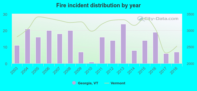 According to the data from the years 2003 - 2018 the average number of fire incidents per year is 14. The highest number of fires - 24 took place in 2013, and the least - 1 in 2010. The data has a decreasing trend.
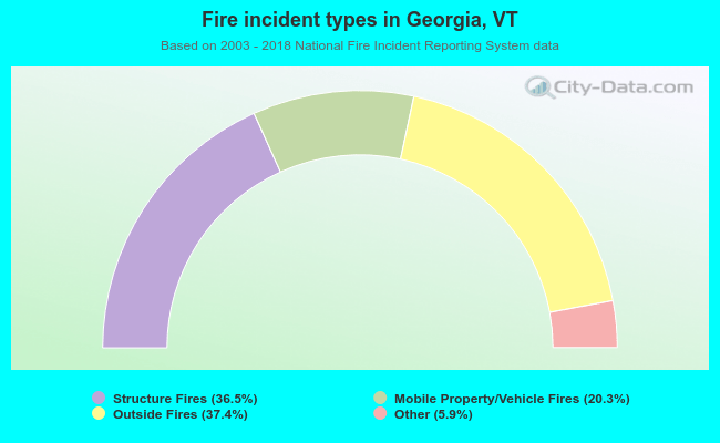 When looking into fire subcategories, the most reports belonged to: Outside Fires (37.4%), and Structure Fires (36.5%).
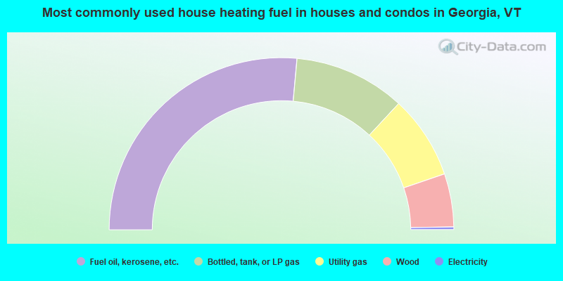
- 52.9%Fuel oil, kerosene, etc.
- 20.9%Bottled, tank, or LP gas
- 15.7%Utility gas
- 10.0%Wood
- 0.5%Electricity
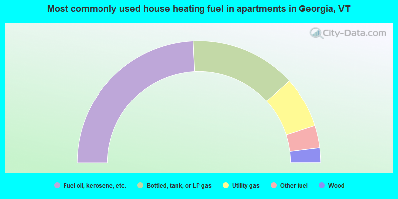
- 48.4%Fuel oil, kerosene, etc.
- 28.1%Bottled, tank, or LP gas
- 13.7%Utility gas
- 5.9%Other fuel
- 3.9%Wood
Georgia compared to Vermont state average:
- Unemployed percentage significantly below state average.
- Black race population percentage significantly below state average.
- Hispanic race population percentage below state average.
- Median age below state average.
- Renting percentage significantly below state average.
- Length of stay since moving in significantly above state average.
- Number of rooms per house significantly below state average.
- House age significantly below state average.
- Number of college students below state average.
- Percentage of population with a bachelor's degree or higher below state average.

|
|
Total of 18 patent applications in 2008-2024.