Gay Hill-Independence, Texas
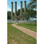
Gay Hill-Independence: independence tx (washington counry)
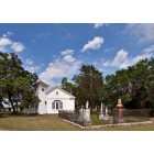
Gay Hill-Independence: Mount Zion Baptist Church
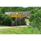
Gay Hill-Independence: one lane bridge-washington co. texas
- add
your
Submit your own pictures of this place and show them to the world
- OSM Map
- Google Map
- MSN Map
| Males: 1,723 | |
| Females: 1,698 |
| Median resident age: | 38.2 years |
| Texas median age: | 32.3 years |
Zip code: 77833
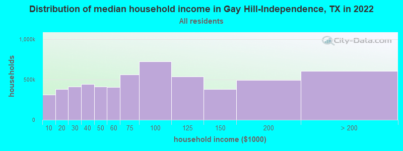
| Gay Hill-Independence: | $76,847 |
| TX: | $72,284 |
Estimated per capita income in 2022: $41,224 (it was $18,014 in 2000)
Gay Hill-Independence CCD income, earnings, and wages data
Estimated median house or condo value in 2022: $284,969 (it was $84,900 in 2000)
| Gay Hill-Independence: | $284,969 |
| TX: | $275,400 |
Gay Hill-Independence, TX residents, houses, and apartments details
Detailed information about poverty and poor residents in Gay Hill-Independence, TX
Compare current foreclosures near your location:
| Photo | Address | Area | Beds / Baths | Price | Details |
|---|---|---|---|---|---|

|
#1
N Rhodes St
Pretty Prairie, KS 67570
|
1,725 sq. feet
|
2 baths 4 beds |
show details | |

|
#2
W 21st St N
Cheney, KS 67025
|
3,190 sq. feet
|
3 baths 5 beds |
show details | |

|
#3
NE Waterloo Ave
Murdock, KS 67111
|
1,220 sq. feet
|
1 baths 3 beds |
show details | |

|
#4
E Arlington Rd
Haven, KS 67543
|
960 sq. feet
|
1 baths 2 beds |
show details | |

|
#5
S Daily Rd
Mount Hope, KS 67108
|
1,828 sq. feet
|
2 baths 2 beds |
show details | |

|
#6
E Winterset St
Goddard, KS 67052
|
816 sq. feet
|
1 baths 2 beds |
show details | |

|
#7
W 39th St S
Goddard, KS 67052
|
4,221 sq. feet
|
3 baths 3 beds |
show details | |

|
#8
E 4th Ave Apt 1
Cheney, KS 67025
|
- sq. feet
|
- baths - beds |
show details | |

|
#9
W Main St
Mount Hope, KS 67108
|
- sq. feet
|
- baths - beds |
show details | |

|
#10
N 189th Cir W
Colwich, KS 67030
|
- sq. feet
|
- baths - beds |
show details |
| Photo | Address | Area | Beds / Baths | Price | Details |
|---|---|---|---|---|---|

|
#11
N Main St
Goddard, KS 67052
|
- sq. feet
|
- baths - beds |
show details | |

|
#12
Martens Ct
Goddard, KS 67052
|
- sq. feet
|
- baths - beds |
show details | |

|
#13
Southwind Ct
Goddard, KS 67052
|
- sq. feet
|
- baths - beds |
show details | |

|
#14
W Maple St Lot D
Goddard, KS 67052
|
- sq. feet
|
- baths - beds |
show details | |

|
#15
S 339th St W
Cheney, KS 67025
|
- sq. feet
|
- baths - beds |
show details | |

|
#16
E Casey Dr
Goddard, KS 67052
|
- sq. feet
|
- baths - beds |
show details | |

|
Check over 1 million property listings on Foreclosure.com!
|
browse all offers | |||

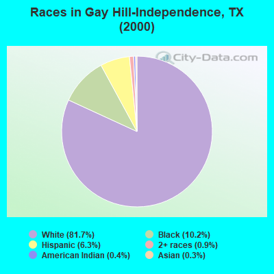
- 2,65081.7%White alone
- 33210.2%Black alone
- 2066.3%Hispanic
- 300.9%Two or more races
- 140.4%American Indian alone
- 110.3%Asian alone
- 20.06%Other race alone
Races in Gay Hill-Independence detailed stats: ancestries, foreign born residents, place of birth
 Recent articles from our blog. Our writers, many of them Ph.D. graduates or candidates, create easy-to-read articles on a wide variety of topics.
Current Local Time: CST time zone
Land area: 140.5 square miles.
Population density: 24 people per square mile (very low).
| Gay Hill-Independence CCD: | 1.3% ($1,142) |
| Texas: | 1.8% ($1,393) |
Nearest city with pop. 50,000+: College Station, TX  (22.5 miles , pop. 67,890).
Nearest city with pop. 200,000+: Northwest Harris, TX (55.4 miles , pop. 405,444).
Nearest city with pop. 1,000,000+: Houston, TX (72.7 miles , pop. 1,953,631).
Nearest cities:
), ), ), Latitude: 30.29 N, Longitude: 96.43 W
Area code commonly used in this area: 979
| Here: | 3.5% |
| Texas: | 3.5% |
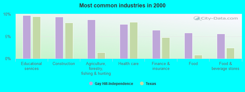
- Educational services (9.7%)
- Construction (9.4%)
- Agriculture, forestry, fishing & hunting (8.8%)
- Health care (7.7%)
- Finance & insurance (6.4%)
- Food (5.8%)
- Food & beverage stores (5.6%)
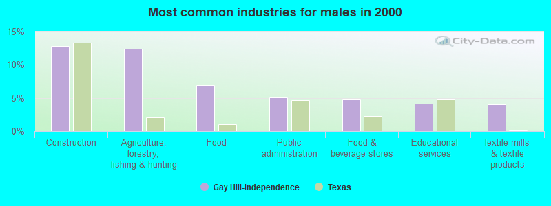
- Construction (12.8%)
- Agriculture, forestry, fishing & hunting (12.4%)
- Food (6.9%)
- Public administration (5.2%)
- Food & beverage stores (4.9%)
- Educational services (4.1%)
- Textile mills & textile products (4.0%)
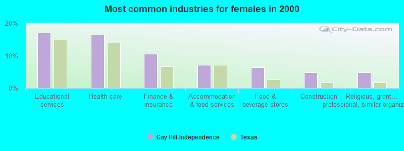
- Educational services (17.1%)
- Health care (16.4%)
- Finance & insurance (10.5%)
- Accommodation & food services (7.1%)
- Food & beverage stores (6.4%)
- Construction (4.8%)
- Religious, grantmaking, civic, professional, similar organizations (4.8%)
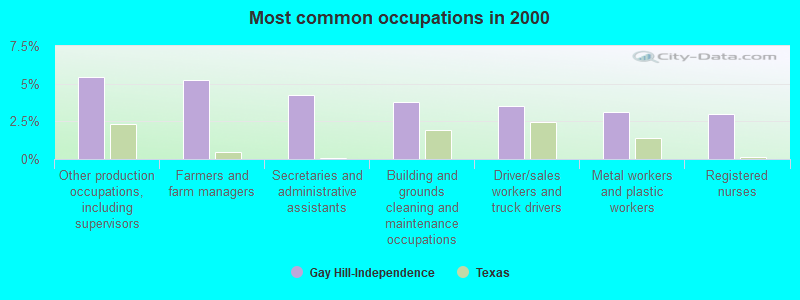
- Other production occupations, including supervisors (5.4%)
- Farmers and farm managers (5.3%)
- Secretaries and administrative assistants (4.2%)
- Building and grounds cleaning and maintenance occupations (3.8%)
- Driver/sales workers and truck drivers (3.5%)
- Metal workers and plastic workers (3.1%)
- Registered nurses (3.0%)
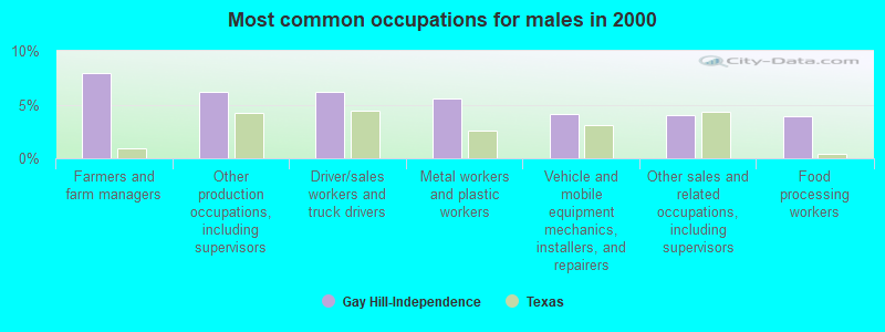
- Farmers and farm managers (8.0%)
- Other production occupations, including supervisors (6.2%)
- Driver/sales workers and truck drivers (6.2%)
- Metal workers and plastic workers (5.5%)
- Vehicle and mobile equipment mechanics, installers, and repairers (4.1%)
- Other sales and related occupations, including supervisors (4.0%)
- Food processing workers (3.9%)
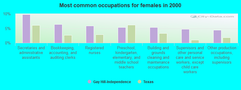
- Secretaries and administrative assistants (9.8%)
- Bookkeeping, accounting, and auditing clerks (6.4%)
- Registered nurses (5.9%)
- Preschool, kindergarten, elementary, and middle school teachers (5.3%)
- Building and grounds cleaning and maintenance occupations (5.3%)
- Supervisors and other personal care and service workers, except child care workers (4.8%)
- Other production occupations, including supervisors (4.5%)
Average climate in Gay Hill-Independence, Texas
Based on data reported by over 4,000 weather stations


(lower is better)
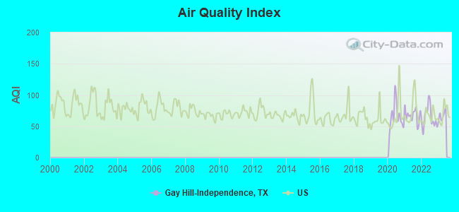
Air Quality Index (AQI) level in 2022 was 63.9. This is about average.
| City: | 63.9 |
| U.S.: | 72.6 |
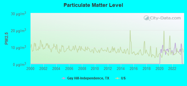
Particulate Matter (PM2.5) [µg/m3] level in 2022 was 7.93. This is about average. Closest monitor was 23.6 miles away from the city center.
| City: | 7.93 |
| U.S.: | 8.11 |
Tornado activity:
Gay Hill-Independence-area historical tornado activity is near Texas state average. It is 40% greater than the overall U.S. average.
On 6/5/1950, a category F3 (max. wind speeds 158-206 mph) tornado 8.0 miles away from the Gay Hill-Independence place center injured 6 people and caused between $50,000 and $500,000 in damages.
On 3/10/2000, a category F3 tornado 8.9 miles away from the place center injured 2 people and caused $1 million in damages.
Earthquake activity:
Gay Hill-Independence-area historical earthquake activity is significantly above Texas state average. It is 25% smaller than the overall U.S. average.On 10/20/2011 at 12:24:41, a magnitude 4.8 (4.8 MW, Depth: 3.1 mi, Class: Light, Intensity: IV - V) earthquake occurred 139.8 miles away from Gay Hill-Independence center
On 5/17/2012 at 08:12:00, a magnitude 4.8 (4.8 MW, Depth: 3.1 mi) earthquake occurred 166.4 miles away from Gay Hill-Independence center
On 6/16/1978 at 11:46:54, a magnitude 5.3 (4.4 MB, 4.6 UK, 5.3 ML, Class: Moderate, Intensity: VI - VII) earthquake occurred 317.7 miles away from Gay Hill-Independence center
On 4/9/1993 at 12:29:19, a magnitude 4.3 (4.1 MB, 4.3 LG, Depth: 3.1 mi) earthquake occurred 144.4 miles away from Gay Hill-Independence center
On 4/14/1995 at 00:32:56, a magnitude 5.7 (5.6 MB, 5.7 MS, 5.7 MW, Depth: 11.1 mi) earthquake occurred 414.1 miles away from the city center
On 9/2/2013 at 23:51:15, a magnitude 4.3 (4.3 MW, Depth: 2.9 mi) earthquake occurred 163.1 miles away from Gay Hill-Independence center
Magnitude types: regional Lg-wave magnitude (LG), body-wave magnitude (MB), local magnitude (ML), surface-wave magnitude (MS), moment magnitude (MW)
Natural disasters:
The number of natural disasters in Washington County (13) is near the US average (15).Major Disasters (Presidential) Declared: 6
Emergencies Declared: 5
Causes of natural disasters: Hurricanes: 5, Floods: 4, Storms: 4, Fires: 3, Tornado: 1, Wind: 1, Other: 1 (Note: some incidents may be assigned to more than one category).
Hospitals and medical centers near Gay Hill-Independence:
- BRENHAM NURSING AND REHABILITATION CENTER (Nursing Home, about 9 miles away; BRENHAM, TX)
- SWEETBRIAR NURSING HOME BRENHAM INC (Nursing Home, about 9 miles away; BRENHAM, TX)
- BRENHAM REST HOME (Nursing Home, about 9 miles away; BRENHAM, TX)
- E F AND BERTHA KRUSE MEMORIAL LUTHERAN VILLAGE (Nursing Home, about 11 miles away; BRENHAM, TX)
- AMA HOME CARE INC (Home Health Center, about 11 miles away; BRENHAM, TX)
- LIBERTY DIALYSIS BRENHAM LLC (Dialysis Facility, about 11 miles away; BRENHAM, TX)
- BOHNE MEMORIAL HOSPITAL (Hospital, about 11 miles away; BRENHAM, TX)
Colleges/universities with over 2000 students nearest to Gay Hill-Independence:
- Blinn College (about 10 miles; Brenham, TX; Full-time enrollment: 8,959)
- Texas A & M University-College Station (about 23 miles; College Station, TX; FT enrollment: 46,550)
- Prairie View A & M University (about 30 miles; Prairie View, TX; FT enrollment: 7,517)
- Lone Star College System (about 57 miles; The Woodlands, TX; FT enrollment: 45,205)
- Sam Houston State University (about 61 miles; Huntsville, TX; FT enrollment: 16,233)
- Universal Technical Institute of Texas Inc. (about 65 miles; Houston, TX; FT enrollment: 3,236)
- Houston Baptist University (about 69 miles; Houston, TX; FT enrollment: 2,340)
Points of interest:
Notable locations in Gay Hill-Independence: Fritz Paul and Emma Schroeder House (A), Prairie Hill Rocky Hill Volunteer Fire Department (B), General J B Robertson Home (C), General Sam Houston Home (D), Prairie Hill Community Hall (E), John Laura Seward Home (F), Asa Hoxey House (G), Reue-Eickenhorst House (H), Red House (I), Mrs Sam Houston House (J). Display/hide their locations on the map
Churches in Gay Hill-Independence include: Saint Johns Church (A), Saint Matthew Church (B), Saint Peter Church (C), Union Hill Church (D), Frieden Church (E), Hopewell Church (F), Mount Zion Church (G), Old Gay Hill Church (H). Display/hide their locations on the map
Cemeteries: Affleck Cemetery (1), Heisic Cemetery (2), Oak Rest Cemetery (3), Eichholt Cemetery (4), Frieden Cemetery (5), Wallace Cemetery (6), Meyer Cemetery (7). Display/hide their locations on the map
Reservoirs: Robbins Lake (A), Lee Lake (B), Johnson Lake (C), Butler Lake (D), McCormick Lake (E). Display/hide their locations on the map
Streams, rivers, and creeks: Bridge Creek (A), Thomas Creek (B), Sweet Water Creek (C), Sandy Branch (D), Old Yegua Creek (E), Old Rocky Creek (F), Hale Branch (G), Hardeman Branch (H), Jerdelle Creek (I). Display/hide their locations on the map
Parks in Gay Hill-Independence include: Yegua Creek Park (1), Overlook Park (2), Baylor University State Park (3). Display/hide their locations on the map
| This place: | 2.5 people |
| Texas: | 2.8 people |
| This place: | 73.3% |
| Whole state: | 69.9% |
| This place: | 5.2% |
| Whole state: | 6.0% |
Likely homosexual households (counted as self-reported same-sex unmarried-partner households)
- Lesbian couples: 0.3% of all households
- Gay men: 0.5% of all households
| This place: | 8.0% |
| Whole state: | 15.4% |
| This place: | 4.9% |
| Whole state: | 6.7% |
For population 15 years and over in Gay Hill-Independence:
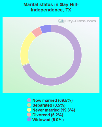
- Never married: 19.3%
- Now married: 69.5%
- Separated: 0.5%
- Widowed: 6.0%
- Divorced: 5.2%
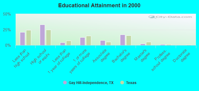
For population 25 years and over in Gay Hill-Independence:
- High school or higher: 79.1%
- Bachelor's degree or higher: 21.1%
- Graduate or professional degree: 4.0%
- Unemployed: 4.1%
- Mean travel time to work (commute): 22.7 minutes
| Here: | 11.8 |
| Texas average: | 15.6 |
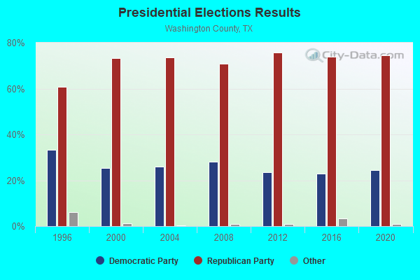
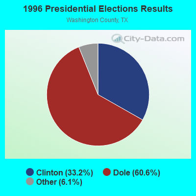
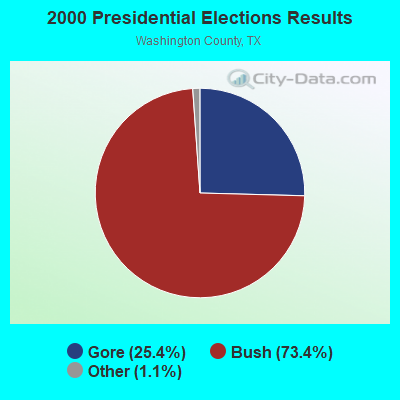

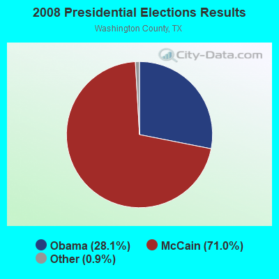
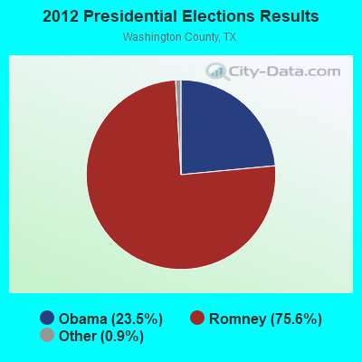
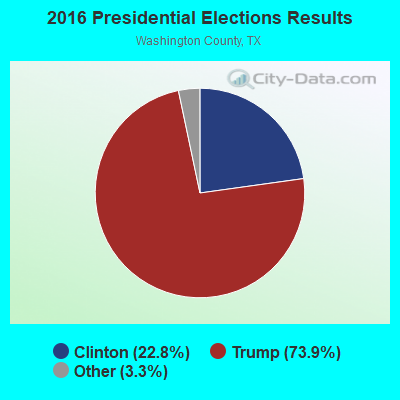
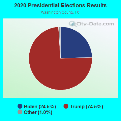
Graphs represent county-level data. Detailed 2008 Election Results
Religion statistics for Gay Hill-Independence, TX (based on Washington County data)
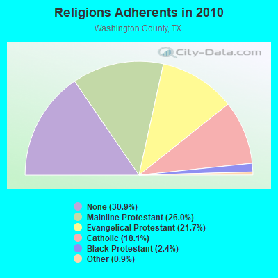
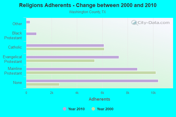
| Religion | Adherents | Congregations |
|---|---|---|
| Mainline Protestant | 8,765 | 22 |
| Evangelical Protestant | 7,300 | 38 |
| Catholic | 6,112 | 3 |
| Black Protestant | 817 | 6 |
| Other | 310 | 2 |
| Orthodox | 6 | 1 |
| None | 10,408 | - |
Food Environment Statistics:
| This county: | 1.88 / 10,000 pop. |
| State: | 1.47 / 10,000 pop. |
| Washington County: | 0.31 / 10,000 pop. |
| Texas: | 0.14 / 10,000 pop. |
| Here: | 0.94 / 10,000 pop. |
| Texas: | 1.11 / 10,000 pop. |
| This county: | 7.20 / 10,000 pop. |
| State: | 3.95 / 10,000 pop. |
| Washington County: | 10.02 / 10,000 pop. |
| Texas: | 6.13 / 10,000 pop. |
| Washington County: | 11.7% |
| Texas: | 8.9% |
| This county: | 29.8% |
| Texas: | 26.6% |
| This county: | 12.9% |
| Texas: | 15.7% |
Strongest AM radio stations in Gay Hill-Independence:
- KZNE (1150 AM; 10 kW; COLLEGE STATION, TX; Owner: BRYAN BROADCASTING LICENSE SUBSIDIARY, INC.)
- KWHI (1280 AM; 1 kW; BRENHAM, TX)
- WTAW (1620 AM; 10 kW; COLLEGE STATION, TX; Owner: BRYAN BROADCASTING LICENSE SUBSIDIARY, INC.)
- KGOL (1180 AM; 50 kW; HUMBLE, TX; Owner: ENTRAVISION HOLDINGS, LLC)
- KSEV (700 AM; 15 kW; TOMBALL, TX; Owner: LIBERMAN BROADCASTING OF HOUSTON LICENSE CORP.)
- KWBC (1550 AM; 5 kW; NAVASOTA, TX)
- KTRH (740 AM; 50 kW; HOUSTON, TX; Owner: AMFM TEXAS LICENSES LIMITED PARTNERSHIP)
- KILE (1560 AM; 50 kW; BELLAIRE, TX; Owner: THE RAFTT CORPORATION)
- KTKR (760 AM; 50 kW; SAN ANTONIO, TX; Owner: CCB TEXAS LICENSES, L.P.)
- WOAI (1200 AM; 50 kW; SAN ANTONIO, TX; Owner: CCB TEXAS LICENSES, L.P.)
- KJOJ (880 AM; 10 kW; CONROE, TX; Owner: LIBERMAN BROADCASTING OF HOUSTON LICENSE CORP.)
- KKYX (680 AM; 50 kW; SAN ANTONIO, TX; Owner: CXR HOLDINGS, INC.)
- KEYH (850 AM; 10 kW; HOUSTON, TX; Owner: LIBERMAN BROADCASTING OF HOUSTON LICENSE CORP.)
Strongest FM radio stations in Gay Hill-Independence:
- KULF (94.1 FM; BRENHAM, TX; Owner: FORT BEND BROADCASTING COMPANY)
- K259AH (91.9 FM; BRENHAM, TX; Owner: THE KSBJ EDUCATIONAL FOUNDATION)
- KTTX (106.1 FM; BRENHAM, TX; Owner: TOM S. WHITEHEAD, INC.)
- KEZB (105.3 FM; HEMPSTEAD, TX; Owner: FARMERS COMMUNICATIONS)
- KMBV (92.5 FM; NAVASOTA, TX; Owner: FORT BEND BROADCASTING COMPANY)
- KORA-FM (98.3 FM; BRYAN, TX; Owner: EQUICOM, INC)
- KLTR (107.3 FM; CALDWELL, TX; Owner: ROY E. HENDERSON)
- KNDE (95.1 FM; COLLEGE STATION, TX; Owner: BRYAN BROADCASTING LICENSE SUBSIDIARY, INC.)
- KAMU-FM (90.9 FM; COLLEGE STATION, TX; Owner: TEXAS A & M UNIVERSITY)
- KNFX-FM (99.5 FM; BRYAN, TX; Owner: CCB TEXAS LICENSES, L.P.)
TV broadcast stations around Gay Hill-Independence:
- KBTX-TV (Channel 3; BRYAN, TX; Owner: KWTX-KBTX LICENSEE CORP.)
- KYLE (Channel 28; BRYAN, TX; Owner: COMCORP OF BRYAN LICENSE CORP.)
- K35DI (Channel 35; SOMERVILLE, TX; Owner: GERALD BENAVIDES)
- KMAY-LP (Channel 23; BRYAN, TX; Owner: CHANNEL 6, INC.)
- K28AK (Channel 28; COLLEGE STATION, TX; Owner: CLEAR CHANNEL BROADCASTING LICENSES, INC.)
- KAMU-TV (Channel 15; COLLEGE STATION, TX; Owner: TEXAS A & M UNIVERSITY)
- KRHD-LP (Channel 34; BRYAN, TX; Owner: CENTEX TELEVISION LIMITED PARTNERSHIP)
- KSCM-LP (Channel 12; BRYAN, TX; Owner: R.D. HARRIS)
- K47ED (Channel 47; COLLEGE STATION, TX; Owner: TRINITY BROADCASTING NETWORK)
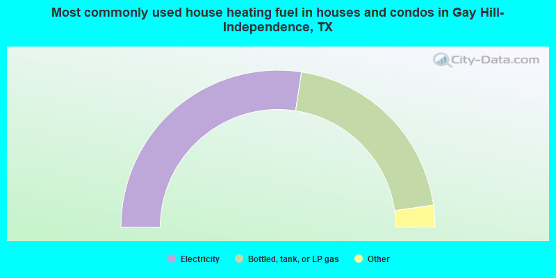
- 54.8%Electricity
- 40.7%Bottled, tank, or LP gas
- 2.8%Wood
- 1.7%Utility gas
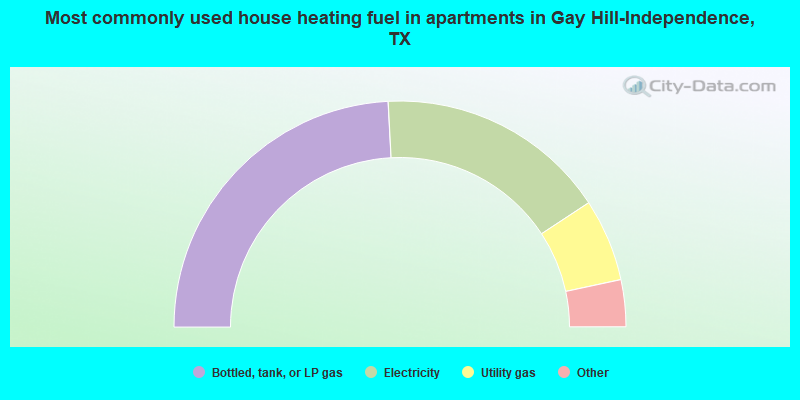
- 48.3%Bottled, tank, or LP gas
- 33.1%Electricity
- 11.8%Utility gas
- 3.9%Wood
- 2.8%Fuel oil, kerosene, etc.
Gay Hill-Independence compared to Texas state average:
- Unemployed percentage significantly below state average.
- Hispanic race population percentage significantly below state average.
- Median age above state average.
- Foreign-born population percentage significantly below state average.
- Renting percentage below state average.
- Length of stay since moving in significantly above state average.
- Number of rooms per house significantly below state average.
- House age significantly below state average.
- Number of college students below state average.