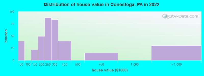
Estimated median house or condo value in 2022: $287,200
Conestoga:
$287,200
PA:
$245,500
Mean prices in 2022:all housing units: $350,912; detached houses: $404,862; mobile homes: $40,194March 2022 cost of living index in Conestoga: 92.6 (less than average, U.S. average is 100)Percentage of residents living in poverty in 2022: 15.6%
According to our research of Pennsylvania and other state lists, there were 2 registered sex offenders living in Conestoga, Pennsylvania as of June 08, 2024. The ratio of all residents to sex offenders in Conestoga is 608 to 1. The ratio of registered sex offenders to all residents in this city is near the state average.
Recent articles from our blog. Our writers, many of them Ph.D. graduates or candidates, create easy-to-read articles on a wide variety of topics.
Ancestries: American (33.8%), German (21.0%), Irish (13.5%), English (5.9%), Polish (2.4%), French Canadian (2.0%).
Current Local Time: EST time zone
27 residents are foreign born (2.1% Asia).
This place:
2.2%
Pennsylvania:
7.3%
Median real estate property taxes paid for housing units with mortgages in 2022: $3,512 (1.3%) Median real estate property taxes paid for housing units with no mortgage in 2022: $2,824 (1.4%)
Nearest city with pop. 50,000+: Lancaster, PA (7.2 miles , pop. 56,348).
Nearest city with pop. 200,000+: Baltimore, MD (46.1 miles , pop. 651,154).
Nearest city with pop. 1,000,000+: Philadelphia, PA (63.8 miles , pop. 1,517,550).
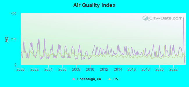
Air Quality Index (AQI) level in 2023 was 132. This is significantly worse than average.
City:
132
U.S.:
73
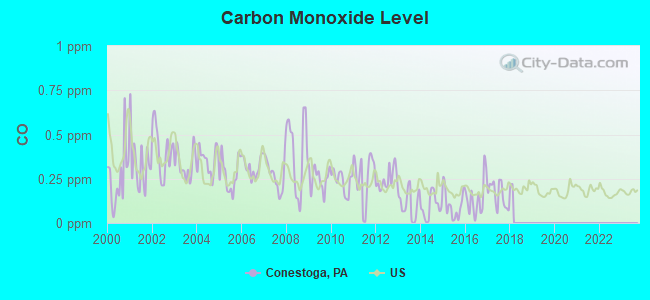
Carbon Monoxide (CO) [ppm] level in 2017 was 0.157. This is significantly better than average.Closest monitor was 8.1 miles away from the city center.
City:
0.157
U.S.:
0.251
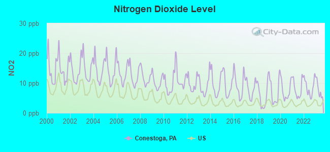
Nitrogen Dioxide (NO2) [ppb] level in 2023 was 7.94. This is significantly worse than average.Closest monitor was 7.3 miles away from the city center.
City:
7.94
U.S.:
5.11
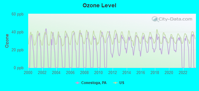
Ozone [ppb] level in 2022 was 29.7. This is about average.Closest monitor was 8.1 miles away from the city center.
City:
29.7
U.S.:
33.3
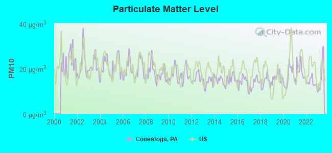
Particulate Matter (PM10) [µg/m3] level in 2023 was 17.3. This is about average.Closest monitor was 8.1 miles away from the city center.
City:
17.3
U.S.:
19.2
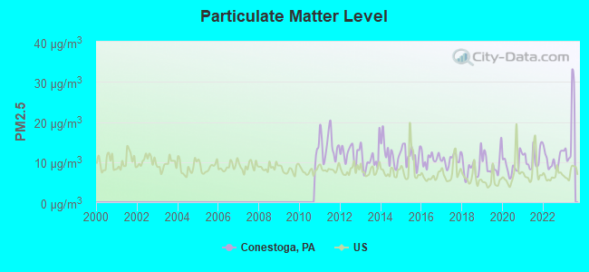
Particulate Matter (PM2.5) [µg/m3] level in 2023 was 17.4. This is significantly worse than average.Closest monitor was 8.1 miles away from the city center.
City:
17.4
U.S.:
8.1
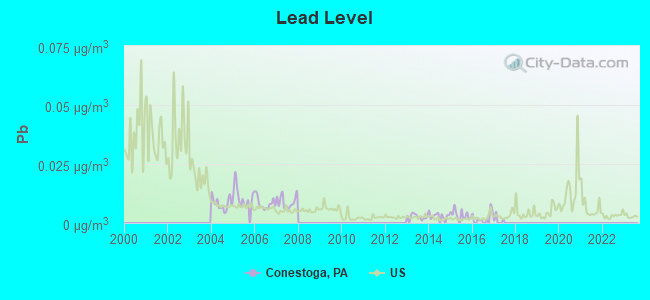
Lead (Pb) [µg/m3] level in 2016 was 0.00190. This is significantly better than average.Closest monitor was 7.2 miles away from the city center.
City:
0.00190
U.S.:
0.00931
Tornado activity:
Conestoga-area historical tornado activity is above Pennsylvania state average. It is 21% greater than the overall U.S. average.
On 4/5/1952, a category F3 (max. wind speeds 158-206 mph) tornado 19.8 miles away from the Conestoga place center injured 4 peopleand causedbetween $500,000 and $5,000,000 in damages.
On 11/4/1950, a category F3 tornado 21.6 miles away from the place center injured one personand causedbetween $50,000 and $500,000 in damages.
Earthquake activity:
Conestoga-area historical earthquake activity is significantly above Pennsylvania state average. It is 61% smaller than the overall U.S. average.
On 8/23/2011 at 17:51:04, a magnitude 5.8 (5.8 MW, Depth: 3.7 mi, Class: Moderate, Intensity: VI - VII) earthquake occurred 164.5 miles away from the city center On 1/16/1994 at 01:49:16, a magnitude 4.6 (4.6 MB, 4.6 LG, Depth: 3.1 mi, Class: Light, Intensity: IV - V) earthquake occurred 31.5 miles away from Conestoga center On 1/16/1994 at 00:42:43, a magnitude 4.2 (4.2 MB, 4.0 LG, Depth: 3.1 mi) earthquake occurred 32.2 miles away from Conestoga center On 9/25/1998 at 19:52:52, a magnitude 5.2 (4.8 MB, 4.3 MS, 5.2 LG, 4.5 MW, Depth: 3.1 mi) earthquake occurred 237.8 miles away from the city center On 10/7/1983 at 10:18:46, a magnitude 5.3 (5.1 MB, 5.3 LG, 5.1 ML) earthquake occurred 296.0 miles away from the city center On 11/30/2017 at 21:47:31, a magnitude 4.1 (4.1 MW, Depth: 6.1 mi) earthquake occurred 70.8 miles away from the city center Magnitude types: regional Lg-wave magnitude (LG), body-wave magnitude (MB), local magnitude (ML), surface-wave magnitude (MS), moment magnitude (MW)
Natural disasters:
The number of natural disasters in Lancaster County (19) is greater than the US average (15). Major Disasters (Presidential) Declared: 14 Emergencies Declared: 5
Causes of natural disasters: Floods: 5, Storms: 5, Winter Storms: 5, Hurricanes: 3, Snowstorms: 3, Tropical Storms: 3, Blizzard: 1, Heavy Rain: 1, Mudslide: 1, Snowfall: 1, Other: 1 (Note: some incidents may be assigned to more than one category).
Hospitals and medical centers near Conestoga:
LAKESIDE AT WILLOW VALLEY (Nursing Home, about 6 miles away; WILLOW STREET, PA)
GLEN AT WILLOW VALLEY, THE (Nursing Home, about 6 miles away; LANCASTER, PA)
WILLOW VALLEY MANOR HEALTHCARE (Nursing Home, about 6 miles away; LANCASTER, PA)
COMMUJITY SERVICES GROUP, INC (Hospital, about 6 miles away; WILLOW, PA)
NEW PROVIDENCE HOME HEALTH CARE SERVICES (Home Health Center, about 7 miles away; NEW PROVIDENCE, PA)
HAMILTON ARMS CENTER (Nursing Home, about 7 miles away; LANCASTER, PA)
MANORCARE HEALTH SERVICES-LANCASTER (Nursing Home, about 7 miles away; LANCASTER, PA)
Amtrak stations near Conestoga:
9 miles: LANCASTER (53 MCGOVERN AVE.) . Services: ticket office, partially wheelchair accessible, enclosed waiting area, public restrooms, public payphones, vending machines, ATM, paid short-term parking, paid long-term parking, call for car rental service, call for taxi service, intercity bus service, public transit connection.
15 miles: MOUNT JOY (DELTA & HENRY STS.) . Services: public payphones, free short-term parking, call for taxi service, public transit connection.
Operable nuclear power plants near Conestoga:
15 miles: Peach Bottom 2 and 3 in Delta, PA.
Colleges/universities with over 2000 students nearest to Conestoga:
Millersville University of Pennsylvania (about 5 miles; Millersville, PA; Full-time enrollment: 7,743)
Franklin and Marshall College (about 8 miles; Lancaster, PA; FT enrollment: 2,585)
YTI Career Institute-York (about 18 miles; York, PA; FT enrollment: 2,212)
York College Pennsylvania (about 21 miles; York, PA; FT enrollment: 5,140)
Lincoln University of Pennsylvania (about 25 miles; Lincoln University, PA; FT enrollment: 2,042)
Harford Community College (about 27 miles; Bel Air, MD; FT enrollment: 4,530)
Pennsylvania State University-Penn State Harrisburg (about 28 miles; Middletown, PA; FT enrollment: 3,797)
Public elementary/middle school in Conestoga:
CONESTOGA EL SCH(Students: 286, Location: 100 HILL ST, Grades: KG-6)
Lancaster County has a predicted average indoor radon screening level greater than 4 pCi/L (pico curies per liter) - Highest Potential
Drinking water stations with addresses in Conestoga and their reported violations in the past:
PROMISED LAND CPGRD (Population served: 160, Groundwater):
Past health violations:
MCL, Monthly (TCR) - Between APR-2007 and JUN-2007, Contaminant: Coliform. Follow-up actions: St Compliance achieved (JUL-19-2007)
Past monitoring violations:
Monitoring, Source Water (GWR) - Between OCT-14-2012 and NOV-14-2012, Contaminant: E. COLI. Follow-up actions: St Compliance achieved (DEC-05-2012)
2 routine major monitoring violations
One minor monitoring violation
2 regular monitoring violations
CONESTOGA HILLS COMMUNITY (Population served: 150, Groundwater):
Past health violations:
Treatment Technique (SWTR and GWR) - In NOV-2013, Contaminant: GROUNDWATER RULE. Follow-up actions: St Public Notif requested (JAN-06-2014), St Formal NOV issued (JAN-06-2014), St Compliance achieved (2 times from JAN-24-2014 to MAR-07-2014), St Public Notif received (MAR-07-2014)
Treatment Technique (SWTR and GWR) - In JAN-2013, Contaminant: GROUNDWATER RULE. Follow-up actions: St Public Notif received (FEB-26-2013), St Compliance achieved (FEB-26-2013), St Formal NOV issued (FEB-26-2013)
Treatment Technique (SWTR and GWR) - In SEP-2012, Contaminant: GROUNDWATER RULE. Follow-up actions: St Formal NOV issued (NOV-02-2012), St Public Notif requested (NOV-02-2012), St Compliance achieved (NOV-16-2012)
Treatment Technique (SWTR and GWR) - In JUL-2012, Contaminant: GROUNDWATER RULE. Follow-up actions: St Public Notif requested (SEP-11-2012), St Formal NOV issued (SEP-11-2012), St Compliance achieved (NOV-02-2012)
Treatment Technique (SWTR and GWR) - In JUN-2012, Contaminant: GROUNDWATER RULE. Follow-up actions: St Public Notif requested (AUG-01-2012), St Formal NOV issued (AUG-01-2012), St Compliance achieved (AUG-16-2012)
Past monitoring violations:
Monitoring of Treatment (SWTR-Unfilt/GWR) - In JUL-2014, Contaminant: GROUNDWATER RULE. Follow-up actions: St Compliance achieved (AUG-26-2014)
Monitoring of Treatment (SWTR-Unfilt/GWR) - In JUN-2014, Contaminant: GROUNDWATER RULE. Follow-up actions: St Compliance achieved (JUL-31-2014)
Monitoring of Treatment (SWTR-Unfilt/GWR) - In NOV-2013, Contaminant: GROUNDWATER RULE. Follow-up actions: St Public Notif requested (JAN-06-2014), St Formal NOV issued (JAN-06-2014), St Compliance achieved (2 times from JAN-24-2014 to MAR-07-2014), St Public Notif received (MAR-07-2014)
Follow-up Or Routine LCR Tap M/R - In OCT-01-2013, Contaminant: Lead and Copper Rule. Follow-up actions: St Violation/Reminder Notice (OCT-31-2013), St Compliance achieved (NOV-19-2013), St Public Notif received (NOV-19-2013)
Drinking water stations with addresses in Conestoga that have no violations reported:
LIFE MINISTRIES (Population served: 100,Primary Water Source Type: Groundwater)
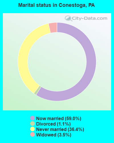
Average household size:
This place:
2.7 people
Pennsylvania:
2.5 people
Percentage of family households:
This place:
79.8%
Whole state:
65.0%
Percentage of households with unmarried partners:
This place:
6.5%
Whole state:
6.6%
Likely homosexual households (counted as self-reported same-sex unmarried-partner households)
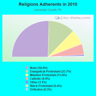
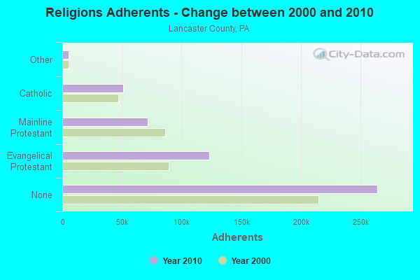
Religion statistics for Conestoga, PA (based on Lancaster County data)
Religion
Adherents
Congregations
Evangelical Protestant
122,957
568
Mainline Protestant
71,573
192
Catholic
51,292
20
Other
5,536
20
Black Protestant
2,163
8
Orthodox
1,600
2
None
264,324
-
Source: Clifford Grammich, Kirk Hadaway, Richard Houseal, Dale E.Jones, Alexei Krindatch, Richie Stanley and Richard H.Taylor. 2012. 2010 U.S.Religion Census: Religious Congregations & Membership Study. Association of Statisticians of American Religious Bodies. Jones, Dale E., et al. 2002. Congregations and Membership in the United States 2000. Nashville, TN: Glenmary Research Center. Graphs represent county-level data
Food Environment Statistics:
Number of grocery stores: 106
Here:
2.13 / 10,000 pop.
Pennsylvania:
2.04 / 10,000 pop.
Number of supercenters and club stores: 4
Here:
0.08 / 10,000 pop.
State:
0.09 / 10,000 pop.
Number of convenience stores (no gas): 31
Lancaster County:
0.62 / 10,000 pop.
Pennsylvania:
0.88 / 10,000 pop.
Number of convenience stores (with gas): 131
Here:
2.63 / 10,000 pop.
State:
2.52 / 10,000 pop.
Number of full-service restaurants: 296
Here:
5.94 / 10,000 pop.
State:
7.12 / 10,000 pop.
Adult diabetes rate:
This county:
8.4%
Pennsylvania:
9.1%
Adult obesity rate:
This county:
27.4%
Pennsylvania:
27.2%
Low-income preschool obesity rate:
Lancaster County:
13.1%
Pennsylvania:
11.5%
4.04% of this county's 2021 resident taxpayers lived in other counties in 2020 ($63,382 average adjusted gross income)
Here:
4.04%
Pennsylvania average:
5.27%
0.01% of residents moved from foreign countries ($104 average AGI)
Lancaster County:
0.01%
Pennsylvania average:
0.01%
Top counties from which taxpayers relocated into this county between 2020 and 2021:
Robert P Donovan, .54 Miles West Southwest Of Intersection Of Pequea Blvd And Coleman Church Rd (Lat: 39.901917 Lon: -76.346472), Type: 42.7, Overall height: 36.6 m, Registrant: County Of Lancaster, 487 Lanca-ster, Phone: (717) 664-1266
Karen Stoner, Township Of Manor, County Of Lancaster, Pa (Lat: 39.960472 Lon: -76.452139), Type: 60.6, Overall height: 59.4 m, Registrant: Minnesota Towers, Inc., Kstoner@minnesotatowers.Com, , Iron -Mountain, Phone: (906) 774-5839
Karen Stoner, Township Of Manor, County Of Lancaster, Pa (Lat: 39.960472 Lon: -76.452139), Type: 60.6, Overall height: 59.4 m, Registrant: Minnesota Towers, Inc., Kstoner@minnesotatowers.Com, , Iron -Mountain, Phone: (906) 774-5839
Robert P Donovan, .54 Miles West Southwest Of Intersection Of Pequea Blvd And Coleman Church Rd (Lat: 39.901917 Lon: -76.346472), Type: 42.7, Overall height: 36.6 m, Registrant: County Of Lancaster, 487 Lanca-ster, Phone: (717) 664-1266
EDWARD T MOORE, Township Of Manor, County Of Lancaster, Pa (Lat: 39.960472 Lon: -76.452139), Type: 60.6, Overall height: 59.4 m, Registrant: Minnesota Towers, Inc., Kstoner@minnesotatowers.Com, , Iron -Mountain, Phone: (906) 774-5839
FCC Registered Broadcast Land Mobile Towers:
7
6975 River Rd (Lat: 39.961778 Lon: -76.341639), Structure height: 11 m, Call Sign: WNYB454, Licensee ID: L00195693, Assigned Frequencies: 464.375 MHz, Grant Date: 03/09/2002, Expiration Date: 04/01/2012, Cancellation Date: 06/02/2012, Registrant: Gault Nursery Corporation, 6970 River Rd, Conestoga, PA 17516, Phone: (717) 872-2000
Lat: 39.950000 Lon: -76.431667, Call Sign: WQEP446, Assigned Frequencies: 160.005 MHz, 151.520 MHz, 154.490 MHz, 159.825 MHz, 160.140 MHz, Grant Date: 01/30/2016, Expiration Date: 03/16/2026, Certifier: Abe Barley, Registrant: B Moyer Radio Communications LLC, 1800 S. Forge Road, Palmyra, PA 17078, Phone: (717) 838-0220, Fax: (717) 838-0225, Email:
Blue Rock 1 & 2 SAD, Blue Rock Trk1 & Trk2 Sad Near Rr Mp Ep 034.10 (Lat: 39.981417 Lon: -76.464194), Type: Building, Structure height: 3 m, Overall height: 6.1 m, Call Sign: WQHT481, Assigned Frequencies: 161.115 MHz, 161.070 MHz, Grant Date: 08/11/2017, Expiration Date: 10/31/2027, Certifier: Jerry R Celio, Registrant: Norfolk Southern Railway Company, 1200 Peachtree Street, Ne,, Atlanta, GA 30309, Phone: (404) 529-1233, Fax: (404) 582-6209, Email:
Lat: 40.037528 Lon: -76.507556, Call Sign: WQID201, Assigned Frequencies: 461.537 MHz, 461.762 MHz, 463.437 MHz, Grant Date: 10/14/2017, Expiration Date: 01/08/2028, Certifier: Darell Donbach, Registrant: Triangle Communications, Inc., 940 West Main Street, New Holland, PA 17557-9391, Phone: (717) 656-2211, Fax: (717) 656-3458, Email:
Lat: 39.956167 Lon: -76.452611, Call Sign: WRDD683, Assigned Frequencies: 462.287 MHz, 467.212 MHz, 467.287 MHz, Grant Date: 04/03/2019, Expiration Date: 04/03/2029, Certifier: Wesley Michael, Registrant: Triangle Communications, Inc., 940 W. Main St., New Holland, PA 17557, Phone: (717) 656-2211, Fax: (717) 656-3458, Email:
Off River Road (Lat: 39.971111 Lon: -76.457944), Type: Mast, Structure height: 6.1 m, Call Sign: WRKB608, Assigned Frequencies: 464.712 MHz, Grant Date: 12/07/2020, Expiration Date: 12/07/2030, Certifier: Randy Ream, Registrant: Triangle Communications, Inc., 940 W. Main St., New Holland, PA 17557, Phone: (717) 656-2211, Fax: (717) 656-3458, Email:
FCC Registered Microwave Towers:
1
PEQUEA, .54 Miles West Southwest Of Intersection Of Pequea Blvd And Coleman Church Rd (Lat: 39.901917 Lon: -76.346472), Type: Mast, Structure height: 36.6 m, Overall height: 42.7 m, Call Sign: WRPJ260, Licensee ID: L00002303, Assigned Frequencies: 6595.00 MHz, Grant Date: 02/10/2022, Expiration Date: 02/10/2032, Certifier: Matt Shenk, Registrant: Lancaster County-Wide Communications, Po Box 487 - 28 South Charlotte St., Manheim, PA 17545, Phone: (717) 664-1100, Fax: (717) 664-1126, Email:
Aircraft: HELTSHE ED STS-1 (Category: Land, Weight: Up to 12,499 Pounds), Engine: None N-Number: 1961G, N1961G, N-1961G, Serial Number: 1296, Airworthiness Date: 04/29/1997, Certificate Issue Date: 11/17/2014 Registrant (Individual): Ed Heltshe, 942 Stone Hill Rd, Conestoga, PA 17516
Aircraft: AVIONS MUDRY CIE CAP 231 (Category: Land, Weight: Up to 12,499 Pounds), Engine: LYCOMING AEIO-540 SER (260 HP) (Reciprocating) N-Number: 231X, N231X, N-231X, Serial Number: 12, Year manufactured: 1990, Airworthiness Date: 03/25/1991, Certificate Issue Date: 12/28/2016 Registrant (Corporation): Airblair Aerobatics LLC, 356 Sand Hill Rd, Conestoga, PA 17516
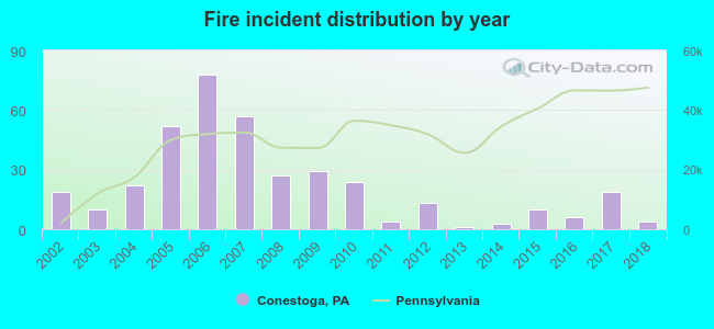
2002 - 2018 National Fire Incident Reporting System (NFIRS) incidents
According to the data from the years 2002 - 2018 the average number of fires per year is 22. The highest number of reported fire incidents - 78 took place in 2006, and the least - 1 in 2013. The data has a decreasing trend.
When looking into fire subcategories, the most incidents belonged to: Structure Fires (64.6%), and Outside Fires (26.2%).
Fire incident types reported to NFIRS in Conestoga, PA


 Recent articles from our blog. Our writers, many of them Ph.D. graduates or candidates, create easy-to-read articles on a wide variety of topics.
 (7.2 miles


 According to the data from the years 2002 - 2018 the average number of fires per year is 22. The highest number of reported fire incidents - 78 took place in 2006, and the least - 1 in 2013. The data has a decreasing trend.
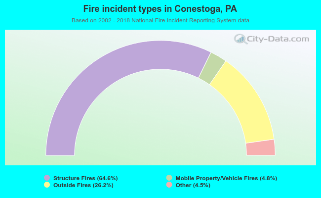 When looking into fire subcategories, the most incidents belonged to: Structure Fires (64.6%), and Outside Fires (26.2%).