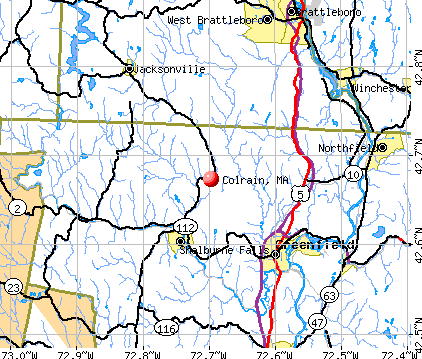
Colrain, Massachusetts
Colrain: Colrain Center, MA

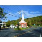
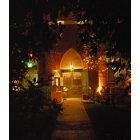
Colrain: Countryside Church, Colrain Center, MA
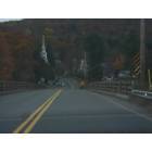
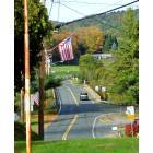
Colrain: Entering Colrain
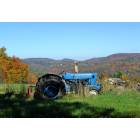
Colrain: Colrain Countryside
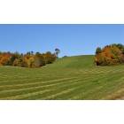
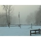
Colrain: Countryside in Colrain
Colrain: Colrain Center, MA
Colrain: North River
Colrain: Mike and Tony's Pizzeria located in a former church in the center of Colrain, MA
- add
your
Submit your own pictures of this town and show them to the world
- OSM Map
- General Map
- Google Map
- MSN Map
Population change since 2000: -7.8%
 |
| Males: 864 | |
| Females: 807 |
| Median resident age: | 46.1 years |
| Massachusetts median age: | 39.2 years |
Zip codes: 01340.
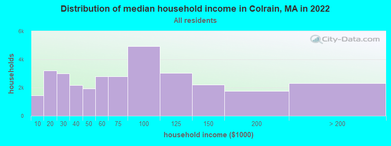
| Colrain: | $69,113 |
| MA: | $94,488 |
Estimated per capita income in 2022: $34,522 (it was $18,948 in 2000)
Colrain town income, earnings, and wages data
Estimated median house or condo value in 2022: $283,310 (it was $114,000 in 2000)
| Colrain: | $283,310 |
| MA: | $534,700 |
Mean prices in 2022: all housing units: $313,377; detached houses: $324,224; townhouses or other attached units: $284,225; in 2-unit structures: $287,978; in 3-to-4-unit structures: $183,938; in 5-or-more-unit structures: $249,762; mobile homes: $62,200
Detailed information about poverty and poor residents in Colrain, MA


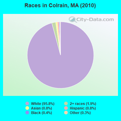
- 1,60195.8%White alone
- 311.9%Two or more races
- 130.8%Asian alone
- 130.8%Hispanic
- 70.4%Black alone
- 50.3%Other race alone
- 10.06%American Indian alone
Races in Colrain detailed stats: ancestries, foreign born residents, place of birth
According to our research of Massachusetts and other state lists, there was 1 registered sex offender living in Colrain, Massachusetts as of June 08, 2024.
The ratio of all residents to sex offenders in Colrain is 1,671 to 1.
The ratio of registered sex offenders to all residents in this city is near the state average.
 Recent articles from our blog. Our writers, many of them Ph.D. graduates or candidates, create easy-to-read articles on a wide variety of topics.

 | Hillbilly Massachusetts (103 replies) |
| MA 2022 Question 1 (258 replies) |
| Geoff Diehl Not Debating Chris Doughty ? (77 replies) |
| Is it possible to escape hunters, ATVs and noise in a rural area? (278 replies) |
| Opinions on Northfield, Shelburne Falls (14 replies) |
| Pioneer Valley: Wood Stoves + Well/Spring Water? (31 replies) |
Latest news from Colrain, MA collected exclusively by city-data.com from local newspapers, TV, and radio stations
Ancestries: English (20.5%), Irish (16.8%), French (13.5%), German (11.3%), French Canadian (9.9%), United States (8.9%).
Current Local Time: EST time zone
Incorporated in 1761
Elevation: 633 feet
Land area: 43.4 square miles.
Population density: 39 people per square mile (very low).
23 residents are foreign born
| This town: | 1.3% |
| Massachusetts: | 12.2% |
| Colrain town: | 1.6% ($1,790) |
| Massachusetts: | 1.3% ($2,336) |
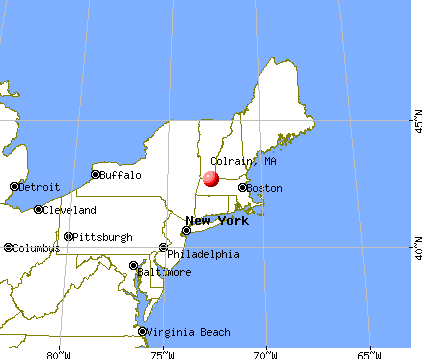
Nearest city with pop. 50,000+: Chicopee, MA  (35.5 miles , pop. 54,653).
Nearest city with pop. 200,000+: Boston, MA (86.4 miles , pop. 589,141).
Nearest city with pop. 1,000,000+: Bronx, NY (139.8 miles , pop. 1,332,650).
Nearest cities:
), ), ), Latitude: 42.67 N, Longitude: 72.71 W
Area code: 413

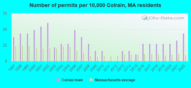
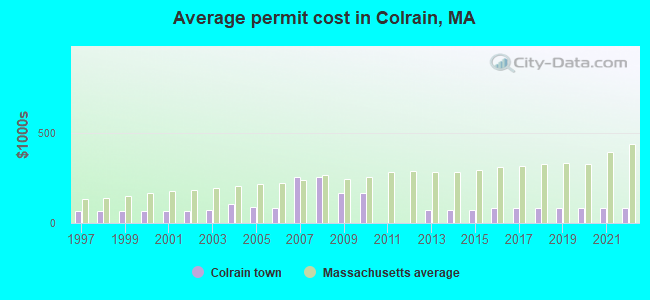
Single-family new house construction building permits:
- 2022: 8 buildings, average cost: $84,400
- 2021: 6 buildings, average cost: $84,400
- 2020: 5 buildings, average cost: $84,400
- 2019: 5 buildings, average cost: $84,400
- 2018: 5 buildings, average cost: $84,400
- 2017: 5 buildings, average cost: $84,400
- 2016: 5 buildings, average cost: $84,400
- 2015: 2 buildings, average cost: $73,200
- 2014: 3 buildings, average cost: $73,200
- 2013: 3 buildings, average cost: $73,200
- 2010: 3 buildings, average cost: $166,300
- 2009: 3 buildings, average cost: $166,300
- 2008: 5 buildings, average cost: $255,300
- 2007: 7 buildings, average cost: $255,300
- 2006: 9 buildings, average cost: $84,600
- 2005: 5 buildings, average cost: $90,400
- 2004: 5 buildings, average cost: $107,000
- 2003: 4 buildings, average cost: $70,500
- 2002: 11 buildings, average cost: $66,700
- 2001: 10 buildings, average cost: $66,700
- 2000: 9 buildings, average cost: $66,700
- 1999: 8 buildings, average cost: $66,700
- 1998: 8 buildings, average cost: $66,700
- 1997: 7 buildings, average cost: $66,700
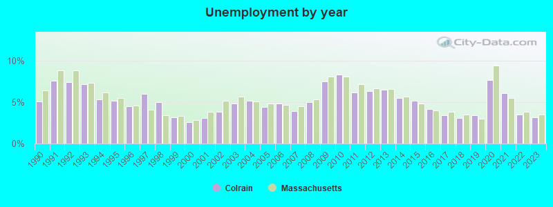
| Here: | 3.2% |
| Massachusetts: | 3.5% |
- Educational services (11.9%)
- Health care (8.7%)
- Construction (6.5%)
- Agriculture, forestry, fishing & hunting (5.9%)
- Accommodation & food services (5.8%)
- Public administration (4.4%)
- Metal & metal products (4.2%)
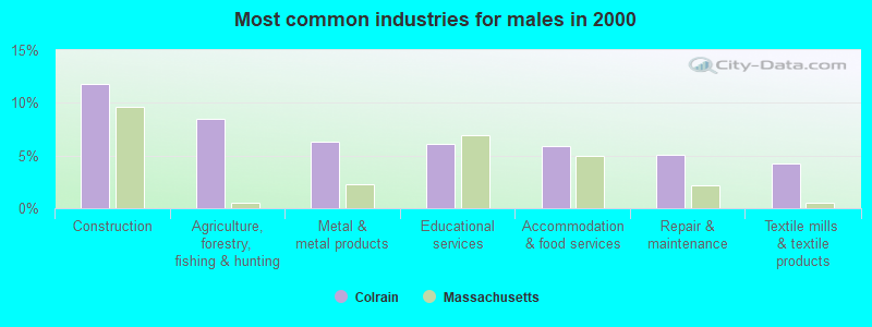
- Construction (11.8%)
- Agriculture, forestry, fishing & hunting (8.5%)
- Metal & metal products (6.3%)
- Educational services (6.1%)
- Accommodation & food services (5.9%)
- Repair & maintenance (5.1%)
- Textile mills & textile products (4.3%)
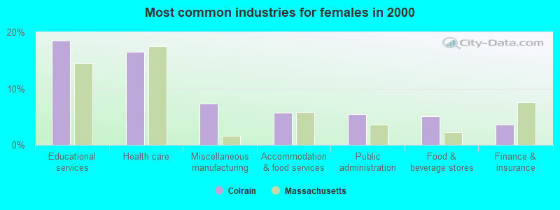
- Educational services (18.5%)
- Health care (16.5%)
- Miscellaneous manufacturing (7.3%)
- Accommodation & food services (5.7%)
- Public administration (5.5%)
- Food & beverage stores (5.0%)
- Finance & insurance (3.7%)

- Other production occupations, including supervisors (5.3%)
- Metal workers and plastic workers (3.8%)
- Farmers and farm managers (3.8%)
- Vehicle and mobile equipment mechanics, installers, and repairers (3.5%)
- Material recording, scheduling, dispatching, and distributing workers (2.9%)
- Electrical equipment mechanics and other installation, maintenance, and repair workers, including supervisors (2.8%)
- Building and grounds cleaning and maintenance occupations (2.8%)
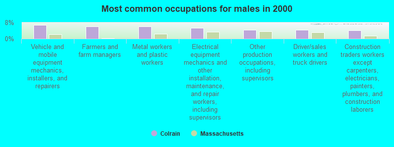
- Vehicle and mobile equipment mechanics, installers, and repairers (6.7%)
- Farmers and farm managers (6.1%)
- Metal workers and plastic workers (6.1%)
- Electrical equipment mechanics and other installation, maintenance, and repair workers, including supervisors (5.3%)
- Other production occupations, including supervisors (4.5%)
- Driver/sales workers and truck drivers (4.5%)
- Construction traders workers except carpenters, electricians, painters, plumbers, and construction laborers (4.1%)
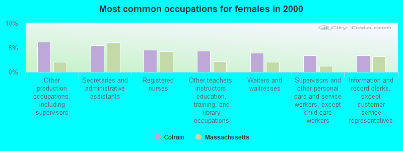
- Other production occupations, including supervisors (6.2%)
- Secretaries and administrative assistants (5.5%)
- Registered nurses (4.6%)
- Other teachers, instructors, education, training, and library occupations (4.3%)
- Waiters and waitresses (3.9%)
- Supervisors and other personal care and service workers, except child care workers (3.4%)
- Information and record clerks, except customer service representatives (3.4%)
Average climate in Colrain, Massachusetts
Based on data reported by over 4,000 weather stations


(lower is better)
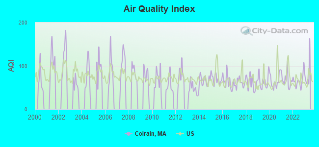
Air Quality Index (AQI) level in 2022 was 65.9. This is about average.
| City: | 65.9 |
| U.S.: | 72.6 |
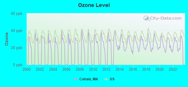
Ozone [ppb] level in 2022 was 23.8. This is better than average. Closest monitor was 7.7 miles away from the city center.
| City: | 23.8 |
| U.S.: | 33.3 |
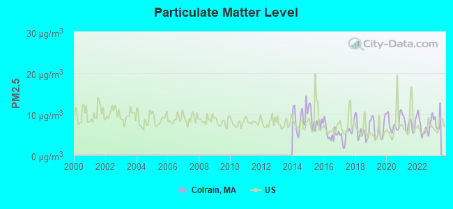
Particulate Matter (PM2.5) [µg/m3] level in 2022 was 7.11. This is about average. Closest monitor was 7.7 miles away from the city center.
| City: | 7.11 |
| U.S.: | 8.11 |
Tornado activity:
Colrain-area historical tornado activity is slightly above Massachusetts state average. It is 18% smaller than the overall U.S. average.
On 6/9/1953, a category F4 (max. wind speeds 207-260 mph) tornado 31.2 miles away from the Colrain town center killed 90 people and injured 1228 people and caused between $50,000,000 and $500,000,000 in damages.
On 8/28/1973, a category F4 tornado 40.0 miles away from the town center killed 4 people and injured 36 people and caused between $5,000,000 and $50,000,000 in damages.
Earthquake activity:
Colrain-area historical earthquake activity is significantly above Massachusetts state average. It is 69% smaller than the overall U.S. average.On 10/7/1983 at 10:18:46, a magnitude 5.3 (5.1 MB, 5.3 LG, 5.1 ML, Class: Moderate, Intensity: VI - VII) earthquake occurred 120.5 miles away from the city center
On 4/20/2002 at 10:50:47, a magnitude 5.3 (5.3 ML, Depth: 3.0 mi) earthquake occurred 136.3 miles away from the city center
On 4/20/2002 at 10:50:47, a magnitude 5.2 (5.2 MB, 4.2 MS, 5.2 MW, 5.0 MW) earthquake occurred 135.1 miles away from Colrain center
On 1/19/1982 at 00:14:42, a magnitude 4.7 (4.5 MB, 4.7 MD, 4.5 LG, Class: Light, Intensity: IV - V) earthquake occurred 80.2 miles away from Colrain center
On 10/16/2012 at 23:12:25, a magnitude 4.7 (4.7 ML, Depth: 10.0 mi) earthquake occurred 122.0 miles away from the city center
On 6/17/1991 at 08:53:16, a magnitude 4.1 (4.0 MB, 4.0 LG, Depth: 3.1 mi) earthquake occurred 99.9 miles away from the city center
Magnitude types: regional Lg-wave magnitude (LG), body-wave magnitude (MB), duration magnitude (MD), local magnitude (ML), surface-wave magnitude (MS), moment magnitude (MW)
Natural disasters:
The number of natural disasters in Franklin County (20) is greater than the US average (15).Major Disasters (Presidential) Declared: 9
Emergencies Declared: 10
Causes of natural disasters: Floods: 5, Storms: 5, Hurricanes: 4, Snowstorms: 4, Winter Storms: 3, Blizzards: 2, Snows: 2, Snowfall: 1, Tropical Storm: 1, Wind: 1, Other: 1 (Note: some incidents may be assigned to more than one category).
Hospitals and medical centers near Colrain:
- ANCHORAGE NURSING HOME (Nursing Home, about 6 miles away; SHELBURNE, MA)
- HOSPICE OF FRANKLIN COUNTY, INC (Hospital, about 8 miles away; GREENFIELD, MA)
- FRANKLIN CENTER (Nursing Home, about 8 miles away; GREENFIELD, MA)
- CHARLENE MANOR EXTENDED CARE FACILITY (Nursing Home, about 8 miles away; GREENFIELD, MA)
- BUCKLEY-GREENFIELD HEALTHCARE CENTER (Nursing Home, about 9 miles away; GREENFIELD, MA)
- HOME CARE PRN INC (Home Health Center, about 9 miles away; GREENFIELD, MA)
- BAYSTATE FRANKLIN MEDICAL CENTER Acute Care Hospitals (about 9 miles away; GREENFIELD, MA)
Operable nuclear power plant near Colrain:
- 12 miles: Vermont Yankee in Vernon, VT.
Colleges/universities with over 2000 students nearest to Colrain:
- University of Massachusetts-Amherst (about 23 miles; Amherst, MA; Full-time enrollment: 26,583)
- Smith College (about 25 miles; Northampton, MA; FT enrollment: 3,549)
- Williams College (about 26 miles; Williamstown, MA; FT enrollment: 2,141)
- Keene State College (about 29 miles; Keene, NH; FT enrollment: 5,098)
- Mount Holyoke College (about 30 miles; South Hadley, MA; FT enrollment: 2,573)
- Holyoke Community College (about 34 miles; Holyoke, MA; FT enrollment: 4,911)
- Franklin Pierce University (about 35 miles; Rindge, NH; FT enrollment: 2,139)
Public elementary/middle school in Colrain:
- COLRAIN CENTRAL (Students: 142, Location: 22 JACKSONVILLE RD, Grades: PK-6)
Points of interest:
Notable locations in Colrain: Pine Hill Orchards (A), Colrain Fire Department (B). Display/hide their locations on the map
Church in Colrain: East Colrain Church (A). Display/hide its location on the map
Cemeteries: Cristian Hill (1), North River Cemetery (2), Branch Cemetery (3), Chandler Hill Cemetery (4), Brick School Cemetery (5). Display/hide their locations on the map
Reservoirs: McLeod Pond (A), Shelburne Falls Fire District Reservoir (B), North River Reservoir (C). Display/hide their locations on the map
Streams, rivers, and creeks: Taylor Brook (A), East Branch North River (B), Fox Brook (C), Foundry Brook (D), Creamery Brook (E), Cary Brook (F), Browning Brook (G), Borden Brook (H), Workman Brook (I). Display/hide their locations on the map
Hotel: High Pocket Bed & Breakfast (17 Fairbanks Rd) (1). Display/hide its approximate location on the map
Birthplace of: William Apess - Pequot author and Methodist preacher, Lorenzo Lyons - Congregationalist cleric.
Drinking water stations with addresses in Colrain and their reported violations in the past:
GRISWOLDVILLE WATER DISTRICT (Address: 22 CALL ROAD , Population served: 125, Groundwater):Past health violations:FOUNDRY BROOK ASSOCIATION (Population served: 28, Groundwater):Past monitoring violations:
- MCL, Monthly (TCR) - In JUL-2013, Contaminant: Coliform. Follow-up actions: St AO (w/o penalty) issued (JUL-26-2013)
- Follow-up Or Routine LCR Tap M/R - In JUN-01-2012, Contaminant: Lead and Copper Rule. Follow-up actions: St AO (w/o penalty) issued (NOV-19-2012)
- Follow-up Or Routine LCR Tap M/R - In OCT-01-2006, Contaminant: Lead and Copper Rule. Follow-up actions: St Compliance achieved (SEP-18-2006), St AO (w/o penalty) issued (DEC-06-2006)
- 39 regular monitoring violations
Past monitoring violations:
- One minor monitoring violation
Drinking water stations with addresses in Colrain that have no violations reported:
- COLRAIN FIRE DISTRICT 1 (Population served: 100, Primary Water Source Type: Groundwater)
| This town: | 2.5 people |
| Massachusetts: | 2.5 people |
| This town: | 64.7% |
| Whole state: | 63.0% |
| This town: | 10.2% |
| Whole state: | 7.0% |
Likely homosexual households (counted as self-reported same-sex unmarried-partner households)
- Lesbian couples: 0.6% of all households
- Gay men: 0.3% of all households
| This town: | 6.8% |
| Whole state: | 9.3% |
| This town: | 2.8% |
| Whole state: | 4.4% |
For population 15 years and over in Colrain:
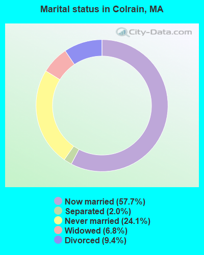
- Never married: 24.1%
- Now married: 57.7%
- Separated: 2.0%
- Widowed: 6.8%
- Divorced: 9.4%
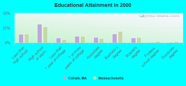
For population 25 years and over in Colrain:
- High school or higher: 85.3%
- Bachelor's degree or higher: 24.7%
- Graduate or professional degree: 9.8%
- Unemployed: 4.9%
- Mean travel time to work (commute): 27.9 minutes
| Here: | 11.1 |
| Massachusetts average: | 13.1 |


Graphs represent county-level data. Detailed 2008 Election Results
Religion statistics for Colrain, MA (based on Franklin County data)


| Religion | Adherents | Congregations |
|---|---|---|
| Catholic | 16,509 | 15 |
| Mainline Protestant | 4,617 | 38 |
| Evangelical Protestant | 2,079 | 20 |
| Other | 1,580 | 21 |
| None | 46,587 | - |
Food Environment Statistics:
| This county: | 3.63 / 10,000 pop. |
| State: | 1.98 / 10,000 pop. |
| This county: | 0.14 / 10,000 pop. |
| Massachusetts: | 0.05 / 10,000 pop. |
| Franklin County: | 1.67 / 10,000 pop. |
| Massachusetts: | 2.22 / 10,000 pop. |
| Franklin County: | 3.21 / 10,000 pop. |
| State: | 1.77 / 10,000 pop. |
| Franklin County: | 8.10 / 10,000 pop. |
| State: | 8.76 / 10,000 pop. |
| Franklin County: | 7.5% |
| Massachusetts: | 8.1% |
| Here: | 22.2% |
| State: | 22.5% |
| Franklin County: | 15.1% |
| Massachusetts: | 16.5% |
Strongest AM radio stations in Colrain:
- WIZZ (1520 AM; daytime; 10 kW; GREENFIELD, MA; Owner: P. & M. RADIO, LLC)
- WNNZ (640 AM; 50 kW; WESTFIELD, MA; Owner: CLEAR CHANNEL BROADCASTING LICENSES, INC.)
- WCRN (830 AM; 50 kW; WORCESTER, MA; Owner: CARTER BROADCASTING CORPORATION)
- WVNE (760 AM; daytime; 25 kW; LEICESTER, MA; Owner: BLOUNT MASSCOM, INC.)
- WHMQ (1240 AM; 1 kW; GREENFIELD, MA; Owner: SAGA COMMUNICATIONS OF NEW ENGLAND, LLC)
- WGY (810 AM; 50 kW; SCHENECTADY, NY; Owner: CLEAR CHANNEL BROADCASTING LICENSES, INC.)
- WTIC (1080 AM; 50 kW; HARTFORD, CT; Owner: INFINITY RADIO OPERATIONS INC.)
- WRKO (680 AM; 50 kW; BOSTON, MA; Owner: ENTERCOM BOSTON LICENSE, LLC)
- WPTR (1540 AM; 50 kW; ALBANY, NY; Owner: KIMTRON, INC.)
- WEEI (850 AM; 50 kW; BOSTON, MA; Owner: ENTERCOM BOSTON LICENSE, LLC)
- WALE (990 AM; 50 kW; GREENVILLE, RI; Owner: NORTH AMERICAN BROADCASTING CO., INC.)
- WKOX (1200 AM; 50 kW; FRAMINGHAM, MA; Owner: CAPSTAR TX LIMITED PARTNERSHIP)
- WBIX (1060 AM; 40 kW; NATICK, MA; Owner: LANGER BROADCASTING CORPORATION)
Strongest FM radio stations in Colrain:
- WPVQ (95.3 FM; GREENFIELD, MA; Owner: GREAT NORTHERN RADIO, L.L.C.)
- WHAI (98.3 FM; GREENFIELD, MA; Owner: SAGA COMMUNICATIONS OF NEW ENGLAND, LLC)
- WAMC-FM (90.3 FM; ALBANY, NY; Owner: WAMC)
- WRSY (101.5 FM; MARLBORO, VT; Owner: GREAT NORTHERN RADIO, L.L.C.)
- WRSI (93.9 FM; TURNERS FALLS, MA; Owner: GREAT NORTHERN RADIO, LLC)
- WVAY (100.7 FM; WILMINGTON, VT; Owner: GREAT NORTHERN RADIO, L.L.C.)
- WEQX (102.7 FM; MANCHESTER, VT; Owner: NORTHSHIRE COMMUNICATIONS, INC.)
- WYRY (104.9 FM; HINSDALE, NH; Owner: TRI-VALLEY BROADCASTING CORPORATION)
- WJAN (95.1 FM; SUNDERLAND, VT; Owner: 6 JOHNSON ROAD LICENSES, INC.)
- WKVT-FM (92.7 FM; BRATTLEBORO, VT; Owner: SAGA COMMUNICATIONS OF NEW ENGLAND, LLC)
- WCMK (91.9 FM; PUTNEY, VT; Owner: CHRISTIAN MINISTRIES INC)
- WFCR (88.5 FM; AMHERST, MA; Owner: UNIVERSITY OF MASSACHUSETTS)
- WGAJ (91.7 FM; DEERFIELD, MA; Owner: TRUATEES OF DEERFIELD ACADEMY)
- WOQL (98.7 FM; WINCHESTER, NH; Owner: SAGA COMMUNICATIONS OF NEW HAMPSHIRE, LLC)
- WHDQ (106.1 FM; CLAREMONT, NH; Owner: GREAT NORTHERN RADIO, L.L.C.)
- WMNB (100.1 FM; NORTH ADAMS, MA; Owner: BERKSHIRE BROADCASTING CO., INC.)
- WHYN-FM (93.1 FM; SPRINGFIELD, MA; Owner: CLEAR CHANNEL BROADCASTING LICENSES, INC.)
- WVPR (89.5 FM; WINDSOR, VT; Owner: VERMONT PUBLIC RADIO)
- WKNE (103.7 FM; KEENE, NH; Owner: SAGA COMMUNICATIONS OF NEW ENGLAND, LLC)
- WJJR (98.1 FM; RUTLAND, VT; Owner: 6 JOHNSON ROAD LICENSES, INC.)
TV broadcast stations around Colrain:
- WYDN (Channel 48; WORCESTER, MA; Owner: EDUCATIONAL PUBLIC TV CORPORATION)
- W35BK (Channel 35; PLAINFIELD, MA; Owner: LYDIA SYLVANE STOCKWELL)
- WEKW-TV (Channel 52; KEENE, NH; Owner: UNIVERSITY OF NEW HAMPSHIRE)
- Colrain, Massachusetts
- Fatal accident count11
- Vehicles involved in fatal accidents11
- Fatal accidents involving drunk persons:5
- Fatalities11
- Persons involved in fatal accidents18
- Pedestrians involved in fatal accidents0
- Massachusetts average
- Fatal accident count5555
- Vehicles involved in fatal accidents7584
- Fatal accidents involving drunk persons1737
- Fatalities6020
- Persons involved in fatal accidents12903
- Pedestrians involved in fatal accidents200
- National Bridge Inventory (NBI) Statistics
- 27Number of bridges
- 230ft / 70.5mTotal length
- $52,256,000Total costs
- 14,795Total average daily traffic
- 968Total average daily truck traffic
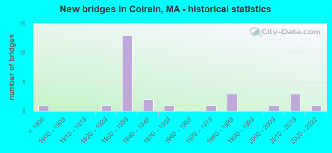
- New bridges - historical statistics
- 1Before 1900
- 11920-1929
- 131930-1939
- 21940-1949
- 11950-1959
- 11970-1979
- 31980-1989
- 12000-2009
- 32010-2019
- 12020-2022
FCC Registered Antenna Towers:
3- Anthony Handley, Greenfield Road (Lat: 42.672472 Lon: -72.684944), Type: 53.3, Structure height: 25011 m, Overall height: 50.6 m, Licensee ID: L, Registrant: Blue Sky Towers Iii, LLC, Chuck.Laurette@blueskytower.Com, Suite 106, North- Reading, Phone: (888) 960-7958
- Anthony Handley, Greenfield Road (Lat: 42.672472 Lon: -72.684944), Type: 53.3, Structure height: 25011 m, Overall height: 50.6 m, Registrant: Blue Sky Towers Iii, LLC, Chuck.Laurette@blueskytower.Com, Suite 106, North- Reading, Phone: (888) 960-7958
- Anthony Handley, Greenfield Road (Lat: 42.672472 Lon: -72.684944), Type: 53.3, Structure height: 25011 m, Overall height: 50.6 m, Registrant: Blue Sky Towers Iii, LLC, Chuck.Laurette@blueskytower.Com, Suite 106, North- Reading, Phone: (888) 960-7958
FCC Registered Broadcast Land Mobile Towers:
1- #2 West Leyden Road (Lat: 42.668056 Lon: -72.682778), Type: Tower, Structure height: 24.4 m, Overall height: 30.5 m, Call Sign: KNDJ506,
Assigned Frequencies: 156.172 MHz, Grant Date: 07/03/2012, Expiration Date: 07/22/2022, Cancellation Date: 09/24/2022, Registrant: Town Of Colrain, Ma, 55 Main Road, Colrain, MA 01340, Phone: (413) 624-6306, Email:
FCC Registered Microwave Towers:
1- COLRAIN, Corner Of Greenfield Rd And W Leyden Rd (Lat: 42.668139 Lon: -72.683056), Type: Mast, Structure height: 30.5 m, Overall height: 38.1 m, Call Sign: WQNL912,
Assigned Frequencies: 11545.0 MHz, 10628.1 MHz, Grant Date: 12/24/2020, Expiration Date: 03/18/2031, Certifier: Charles B Sutherland, Registrant: Massachusetts, Commonwealth Of, 470 Worcester Rd, Framingham, MA 01702, Phone: (508) 820-2264, Email:
FCC Registered Amateur Radio Licenses:
16 (See the full list of FCC Registered Amateur Radio Licenses in Colrain)FAA Registered Aircraft:
1- Aircraft: AIR CREATION CLIPPER 582S (Category: Land, Seats: 2, Weight: Up to 12,499 Pounds), Engine: ROTAX 582SER (65 HP) (2 Cycle)
N-Number: 623PC, N623PC, N-623PC, Serial Number: T99016, Year manufactured: 2001, Airworthiness Date: 01/10/2010, Certificate Issue Date: 06/07/2007
Registrant (Individual): Patrick M Shippee, 224 Ed Clark Rd, Colrain, MA 01340
2002 - 2018 National Fire Incident Reporting System (NFIRS) incidents
- Fire incident types reported to NFIRS in Colrain, MA
- 17759.4%Structure Fires
- 9230.9%Outside Fires
- 165.4%Mobile Property/Vehicle Fires
- 134.4%Other
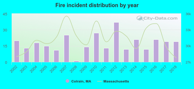 Based on the data from the years 2002 - 2018 the average number of fire incidents per year is 18. The highest number of fire incidents - 37 took place in 2012, and the least - 1 in 2008. The data has a declining trend.
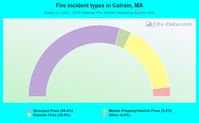 When looking into fire subcategories, the most incidents belonged to: Structure Fires (59.4%), and Outside Fires (30.9%).
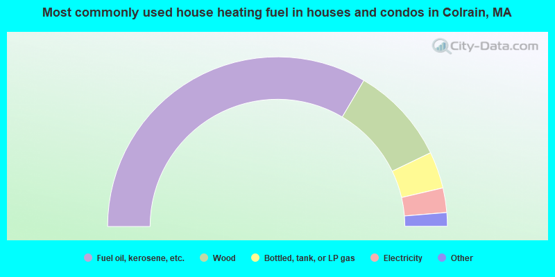
- 67.0%Fuel oil, kerosene, etc.
- 18.7%Wood
- 7.0%Bottled, tank, or LP gas
- 4.7%Electricity
- 1.4%Other fuel
- 0.9%Coal or coke
- 0.3%Solar energy
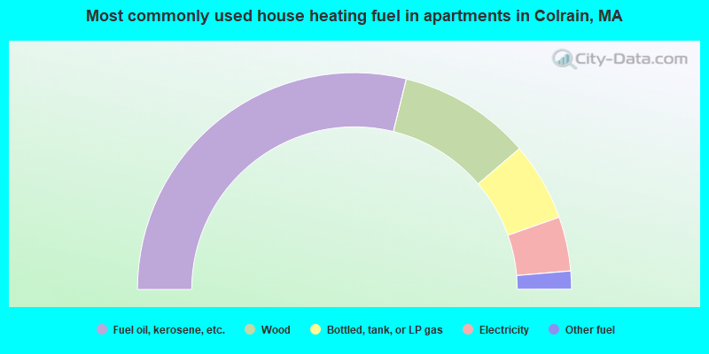
- 57.7%Fuel oil, kerosene, etc.
- 19.8%Wood
- 11.7%Bottled, tank, or LP gas
- 8.1%Electricity
- 2.7%Other fuel
Colrain compared to Massachusetts state average:
- Median house value below state average.
- Unemployed percentage significantly below state average.
- Black race population percentage significantly below state average.
- Hispanic race population percentage significantly below state average.
- Median age above state average.
- Foreign-born population percentage significantly below state average.
- Renting percentage significantly below state average.
- Length of stay since moving in significantly above state average.
- Number of rooms per house significantly below state average.
- House age significantly below state average.
- Number of college students below state average.