Bridge Statistics for Yucaipa, California (CA)
Condition, Traffic, Stress, Structural Evaluation, Project Costs
- National Bridge Inventory (NBI) Statistics
- 25Number of bridges
- 226ft / 68.7mTotal length
- $602,000Total costs
- 851,496Total average daily traffic
- 117,218Total average daily truck traffic
- National Bridge Inventory (NBI) Registered Bridges for Yucaipa
- No street view available for this location
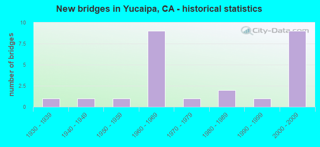
- New bridges - historical statistics
- 11930-1939
- 11940-1949
- 11950-1959
- 91960-1969
- 11970-1979
- 21980-1989
- 11990-1999
- 92000-2009

- Reconstructed bridges - Historical Statistics
- 11940-1949
- 01950-1959
- 01960-1969
- 01970-1979
- 01980-1989
- 01990-1999
- 12000-2009


- Bridge Condition - Deck
- 41.7%Good
- 50.0%Fair
- 8.3%Poor

- Bridge Condition - Superstructure
- 91.7%Good
- 8.3%Fair

- Bridge Condition - Substructure
- 66.7%Good
- 33.3%Fair

- Bridge Condition - Channel
- 11.1%Excellent
- 66.7%Very good
- 22.2%Good

- Bridge Condition - Culverts
- 30.0%Good
- 60.0%Satisfactory
- 10.0%Poor
Find on map >> Show street view
Structure Number: 54 0312, Location: 08-SBD-010-R38.53 (Lat: 34.011433, Lng: -117.071264), Route carried "on" structure: Interstate 10, Year Built: 1965, Status: Open, Structure Length: 1.49m (4.89ft), Average Daily Traffic: 132,000 (year 2018), Truck Traffic: 16%, Average Future Daily Traffic: 150,000 (year 2040), Features Intersected: WILDWOOD CREEK
Minimum Vertical Clearance: 30+ m (98+ ft), Kilometerpoint: 38.530, Lanes on structure: 6, Base Highway Network: Yes (, Subroute: 1), Owner: State Highway Agency, Approaching Roadway Width: 33.9m (111.2ft), Skew: 5 degrees, Material/Design: Concrete continuous, Design/Construction: Culvert, Number Of Spans In Main Unit: 2, Length of Maximum Span: 7.0m (23.0ft), Curb-To-Curb Width: 33.9m (111.2ft), Out-to-Out Width: 47.5m (155.8ft)
Condition: Channel: Good, Culverts: Good, Operating Rating: 54.1 metric tons, Method Used To Determine Operating Rating: Field evaluation and documented engineering judgment, Inventory Rating: 32.4 metric tons, Method Used To Determine Inventory Rating: Field evaluation and documented engineering judgment, Structural Evaluation: Better than present minimum criteria, Deck Geometry: Superior to present desirable criteria, Waterway Adequacy: Better than present minimum criteria, Approach Roadway Alignment: Equal to present desirable criteria, Designated Inspection Frequency: Every 24 months, Inspection Date: March 2020
Find on map >> Show street view
Structure Number: 54 0346, Location: 08-SBD-038-9.60 (Lat: 34.090606, Lng: -117.037269), Route carried "on" structure: State highway 38, Year Built: 1947, Year Reconstructed: 2007, Status: Open, Structure Length: 4.94m (16.21ft), Average Daily Traffic: 5,000 (year 2017), Truck Traffic: 9%, Average Future Daily Traffic: 7,800 (year 2040), Design Load: HS 20, Features Intersected: MILL CREEK
Minimum Vertical Clearance: 30+ m (98+ ft), Kilometerpoint: 9.600, Lanes on structure: 2, Base Highway Network: Yes, Owner: State Highway Agency, Approaching Roadway Width: 12.9m (42.3ft), Skew: 2 degrees, Material/Design: Steel continuous, Design/Construction: Stringer/Multi-beam, Number Of Spans In Main Unit: 2, Length of Maximum Span: 41.1m (134.8ft), Curb-To-Curb Width: 12.9m (42.3ft), Out-to-Out Width: 13.8m (45.3ft)
Condition: Deck: Good, Superstructure: Good, Substructure: Fair, Channel: Very good, Operating Rating: 79.4 metric tons, Method Used To Determine Operating Rating: Load Factor (LF), Inventory Rating: 47.3 metric tons, Method Used To Determine Inventory Rating: Load Factor (LF), Structural Evaluation: Somewhat better than minimum adequacy, Deck Geometry: Equal to present minimum criteria, Waterway Adequacy: Better than present minimum criteria, Approach Roadway Alignment: Better than present minimum criteria, Length Of Structure Improvement: 4.94m (16.21ft), Designated Inspection Frequency: Every 24 months, Inspection Date: September 2020, Deck Structure Type: Concrete Cast-file-Place, Wearing Surface/Protective System: Wearing Surface: Integral Concrete
Find on map >> Show street view
Structure Number: 54 0495, Location: 08-SBD-010-35.50-YUCP (Lat: 34.027081, Lng: -117.119350), Route carried "on" structure: City street R013, Year Built: 1989, Status: Open, Structure Length: 6.10m (20.01ft), Average Daily Traffic: 19,800 (year 2016), Truck Traffic: 5%, Average Future Daily Traffic: 24,000 (year 2036), Design Load: HS 20+Mod, Features Intersected: INTERSTATE 10, Facility Carried by Structure: YUCAIPA BLVD
Minimum Vertical Clearance: 30+ m (98+ ft), Kilometerpoint: 0.000, Lanes on structure: 6, Lanes under structure: 8, Base Highway Network: Yes, Owner: State Highway Agency, Approaching Roadway Width: 24.1m (79.1ft), Material/Design: Prestressed concrete, Design/Construction: Stringer/Multi-beam, Number Of Spans In Main Unit: 2, Length of Maximum Span: 30.2m (99.1ft), Curb or Sidewalk Widths: Left: 0.0m, Right: 1.5m (4.9ft), Curb-To-Curb Width: 24.1m (79.1ft), Out-to-Out Width: 26.5m (86.9ft)
Condition: Deck: Good, Superstructure: Good, Substructure: Good, Operating Rating: 54.1 metric tons, Method Used To Determine Operating Rating: Assigned rating based on Load Factor Design (LFD) reported in metric tons, Inventory Rating: 32.4 metric tons, Method Used To Determine Inventory Rating: Assigned rating based on Load Factor Design (LFD) reported in metric tons, Structural Evaluation: Better than present minimum criteria, Deck Geometry: Somewhat better than minimum adequacy, Underclear: Meets minimum limits, Approach Roadway Alignment: Equal to present desirable criteria, Designated Inspection Frequency: Every 48 months, Inspection Date: May 2018, Deck Structure Type: Concrete Cast-file-Place
Find on map >> Show street view
Structure Number: 54 061, Location: 08-SBD-127-L0.01 (Lat: 35.263175, Lng: -116.072900), Route carried "on" structure: State highway 127, Year Built: 1965, Status: Open, Structure Length: 7.41m (24.31ft), Average Daily Traffic: 6,800 (year 2016), Truck Traffic: 12%, Average Future Daily Traffic: 10,000 (year 2038), Design Load: HS 20, Features Intersected: INTERSTATE 15
Minimum Vertical Clearance: 30+ m (98+ ft), Kilometerpoint: 0.010, Lanes on structure: 2, Lanes under structure: 4, Base Highway Network: Yes (Inventory Route: 1, Subroute: 1), Owner: State Highway Agency, Approaching Roadway Width: 8.5m (27.9ft), Material/Design: Steel, Design/Construction: Stringer/Multi-beam, Number Of Spans In Main Unit: 4, Length of Maximum Span: 26.5m (86.9ft), Curb or Sidewalk Widths: Left: 0.6m (2.0ft), Right: 0.6m (2.0ft), Curb-To-Curb Width: 8.5m (27.9ft), Out-to-Out Width: 10.4m (34.1ft)
Condition: Deck: Good, Superstructure: Good, Substructure: Fair, Operating Rating: 82.9 metric tons, Method Used To Determine Operating Rating: Load Factor (LF), Inventory Rating: 49.9 metric tons, Method Used To Determine Inventory Rating: Load Factor (LF), Structural Evaluation: Somewhat better than minimum adequacy, Deck Geometry: Meets minimum limits, Underclear: Meets minimum limits, Approach Roadway Alignment: Equal to present desirable criteria, Designated Inspection Frequency: Every 24 months, Inspection Date: December 2021, Deck Structure Type: Concrete Cast-file-Place, Wearing Surface/Protective System: Wearing Surface: Integral Concrete
Find on map >> Show street view
Structure Number: 54 0615, Location: 08-SBD-010-36.44-YUCP (Lat: 34.022189, Lng: -117.104119), Route carried "on" structure: City street , Year Built: 1962, Status: Open, Structure Length: 7.44m (24.41ft), Average Daily Traffic: 900 (year 2016), Truck Traffic: 1%, Average Future Daily Traffic: 1,224 (year 2042), Design Load: HS 20, Features Intersected: INTERSTATE 10, Facility Carried by Structure: 16TH STREET
Minimum Vertical Clearance: 30+ m (98+ ft), Kilometerpoint: 0.000, Lanes on structure: 2, Lanes under structure: 8, Owner: State Highway Agency, Approaching Roadway Width: 8.5m (27.9ft), Skew: 1 degrees, Material/Design: Prestressed concrete, Design/Construction: Stringer/Multi-beam, Number Of Spans In Main Unit: 2, Number Of Approach Spans: 2, Length of Maximum Span: 24.7m (81.0ft), Curb or Sidewalk Widths: Left: 1.5m (4.9ft), Right: 0.6m (2.0ft), Curb-To-Curb Width: 8.5m (27.9ft), Out-to-Out Width: 11.3m (37.1ft)
Condition: Deck: Fair, Superstructure: Good, Substructure: Good, Operating Rating: 39.9 metric tons, Method Used To Determine Operating Rating: Load and Resistance Factor Rating (LRFR) rating reported by rating factor(RF) method using HL-93 loadings, Inventory Rating: 27.2 metric tons, Method Used To Determine Inventory Rating: Load and Resistance Factor Rating (LRFR) rating reported by rating factor(RF) method using HL-93 loadings, Structural Evaluation: Equal to present minimum criteria, Deck Geometry: Somewhat better than minimum adequacy, Underclear: High priority of corrective action, Approach Roadway Alignment: Better than present minimum criteria, Designated Inspection Frequency: Every 24 months, Inspection Date: March 2020, Deck Structure Type: Concrete Cast-file-Place
Find on map >> Show street view
Structure Number: 54 0648L, Location: 08-SBD-010-R36.90-YUCP (Lat: 34.017806, Lng: -117.097697), Route carried "on" structure: Interstate 10, Year Built: 1964, Status: Open, Structure Length: 3.51m (11.52ft), Average Daily Traffic: 61,000 (year 2018), Truck Traffic: 16%, Average Future Daily Traffic: 75,000 (year 2040), Design Load: HS 20, Features Intersected: OAK GLEN CREEK
Minimum Vertical Clearance: 30+ m (98+ ft), Kilometerpoint: 36.900, Lanes on structure: 4, Base Highway Network: Yes (, Subroute: 1), Owner: State Highway Agency, Approaching Roadway Width: 19.5m (64.0ft), Skew: 1 degrees, Material/Design: Concrete continuous, Design/Construction: Tee Beam, Number Of Spans In Main Unit: 3, Length of Maximum Span: 16.5m (54.1ft), Curb-To-Curb Width: 19.5m (64.0ft), Out-to-Out Width: 25.0m (82.0ft)
Condition: Deck: Fair, Superstructure: Good, Substructure: Good, Channel: Very good, Operating Rating: 45.4 metric tons, Method Used To Determine Operating Rating: Load Factor (LF), Inventory Rating: 27.2 metric tons, Method Used To Determine Inventory Rating: Load Factor (LF), Structural Evaluation: Equal to present minimum criteria, Deck Geometry: Somewhat better than minimum adequacy, Waterway Adequacy: Equal to present desirable criteria, Approach Roadway Alignment: Equal to present desirable criteria, Designated Inspection Frequency: Every 24 months, Inspection Date: March 2020, Deck Structure Type: Concrete Cast-file-Place
Find on map >> Show street view
Structure Number: 54 0648R, Location: 08-SBD-010-R36.90-YUCP (Lat: 34.017681, Lng: -117.097914), Route carried "on" structure: Interstate 10, Year Built: 1964, Status: Open, Structure Length: 3.51m (11.52ft), Average Daily Traffic: 61,000 (year 2014), Truck Traffic: 16%, Average Future Daily Traffic: 75,000 (year 2040), Design Load: HS 20, Features Intersected: OAK GLEN CREEK
Minimum Vertical Clearance: 30+ m (98+ ft), Kilometerpoint: 36.900, Lanes on structure: 3, Base Highway Network: Yes (, Subroute: 1), Owner: State Highway Agency, Approaching Roadway Width: 16.5m (54.1ft), Skew: 1 degrees, Material/Design: Concrete continuous, Design/Construction: Tee Beam, Number Of Spans In Main Unit: 3, Length of Maximum Span: 16.5m (54.1ft), Curb-To-Curb Width: 16.5m (54.1ft), Out-to-Out Width: 17.1m (56.1ft)
Condition: Deck: Fair, Superstructure: Good, Substructure: Good, Channel: Very good, Operating Rating: 40.2 metric tons, Method Used To Determine Operating Rating: Load and Resistance Factor Rating (LRFR) rating reported by rating factor(RF) method using HL-93 loadings, Inventory Rating: 28.5 metric tons, Method Used To Determine Inventory Rating: Load and Resistance Factor Rating (LRFR) rating reported by rating factor(RF) method using HL-93 loadings, Structural Evaluation: Better than present minimum criteria, Deck Geometry: Equal to present minimum criteria, Waterway Adequacy: Equal to present desirable criteria, Approach Roadway Alignment: Equal to present desirable criteria, Designated Inspection Frequency: Every 24 months, Inspection Date: March 2020, Deck Structure Type: Concrete Cast-file-Place
Find on map >> Show street view
Structure Number: 54 0648S, Location: 08-SBD-010-R36.90-YUCP (Lat: 34.017575, Lng: -117.098150), Route carried "on" structure: Ramp Interstate 10, Year Built: 1965, Status: Open, Structure Length: 3.51m (11.52ft), Average Daily Traffic: 12,377 (year 2018), Truck Traffic: 12%, Average Future Daily Traffic: 15,000 (year 2040), Design Load: HS 20, Features Intersected: OAK GLEN CREEK
Minimum Vertical Clearance: 30+ m (98+ ft), Kilometerpoint: 36.900, Lanes on structure: 1, Base Highway Network: Yes (, Subroute: 1), Owner: State Highway Agency, Approaching Roadway Width: 6.7m (22.0ft), Skew: 1 degrees, Material/Design: Concrete continuous, Design/Construction: Tee Beam, Number Of Spans In Main Unit: 3, Length of Maximum Span: 16.5m (54.1ft), Curb or Sidewalk Widths: Left: 0.6m (2.0ft), Right: 0.0m, Curb-To-Curb Width: 6.7m (22.0ft), Out-to-Out Width: 7.9m (25.9ft)
Condition: Deck: Good, Superstructure: Good, Substructure: Good, Channel: Very good, Operating Rating: 36.6 metric tons, Method Used To Determine Operating Rating: Load and Resistance Factor Rating (LRFR) rating reported by rating factor(RF) method using HL-93 loadings, Inventory Rating: 25.9 metric tons, Method Used To Determine Inventory Rating: Load and Resistance Factor Rating (LRFR) rating reported by rating factor(RF) method using HL-93 loadings, Structural Evaluation: Equal to present minimum criteria, Deck Geometry: Equal to present minimum criteria, Waterway Adequacy: Equal to present desirable criteria, Approach Roadway Alignment: Equal to present desirable criteria, Designated Inspection Frequency: Every 24 months, Inspection Date: March 2020, Deck Structure Type: Concrete Cast-file-Place, Wearing Surface/Protective System: Wearing Surface: Bituminous
Find on map >> Show street view
Structure Number: 54 1046, Location: 08-SBD-038-R12.28 (Lat: 34.102467, Lng: -116.998403), Route carried "on" structure: State highway 38, Year Built: 1978, Status: Open, Structure Length: 7.07m (23.20ft), Average Daily Traffic: 5,000 (year 2017), Truck Traffic: 9%, Average Future Daily Traffic: 7,800 (year 2040), Design Load: HS 20, Features Intersected: MOUNTAIN HOME CREEK
Minimum Vertical Clearance: 30+ m (98+ ft), Kilometerpoint: 12.280, Lanes on structure: 2, Base Highway Network: Yes, Owner: State Highway Agency, Approaching Roadway Width: 13.4m (44.0ft), Skew: 4 degrees, Material/Design: Concrete continuous, Design/Construction: Box Beam or Girders - Multiple, Number Of Spans In Main Unit: 3, Length of Maximum Span: 27.1m (88.9ft), Curb-To-Curb Width: 13.4m (44.0ft), Out-to-Out Width: 14.3m (46.9ft)
Condition: Deck: Fair, Superstructure: Good, Substructure: Good, Channel: Very good, Operating Rating: 69.0 metric tons, Method Used To Determine Operating Rating: Load and Resistance Factor Rating (LRFR) rating reported by rating factor(RF) method using HL-93 loadings, Inventory Rating: 50.9 metric tons, Method Used To Determine Inventory Rating: Load and Resistance Factor Rating (LRFR) rating reported by rating factor(RF) method using HL-93 loadings, Structural Evaluation: Better than present minimum criteria, Deck Geometry: Better than present minimum criteria, Waterway Adequacy: Equal to present desirable criteria, Approach Roadway Alignment: Equal to present desirable criteria, Designated Inspection Frequency: Every 24 months, Inspection Date: Febuary 2021, Deck Structure Type: Concrete Cast-file-Place
Find on map >> Show street view
Structure Number: 54 1291, Location: 08-SBD-010-R37.03-YUCP (Lat: 34.016994, Lng: -117.095781), Route carried "on" structure: City street , Year Built: 2009, Status: Open, Structure Length: 7.89m (25.89ft), Average Daily Traffic: 10,000 (year 2018), Truck Traffic: 5%, Average Future Daily Traffic: 20,000 (year 2040), Design Load: HS 20+Mod, Features Intersected: INTERSTATE 10, Facility Carried by Structure: LIVE OAK CANYON RD
Minimum Vertical Clearance: 30+ m (98+ ft), Kilometerpoint: 0.000, Lanes on structure: 5, Lanes under structure: 6, Owner: State Highway Agency, Approaching Roadway Width: 26.4m (86.6ft), Skew: 1 degrees, Material/Design: Prestressed concrete continuous, Design/Construction: Box Beam or Girders - Multiple, Number Of Spans In Main Unit: 2, Length of Maximum Span: 40.2m (131.9ft), Curb or Sidewalk Widths: Left: 1.8m (5.9ft), Right: 1.8m (5.9ft), Curb-To-Curb Width: 25.8m (84.6ft), Out-to-Out Width: 26.4m (86.6ft)
Condition: Deck: Fair, Superstructure: Good, Substructure: Good, Operating Rating: 54.1 metric tons, Method Used To Determine Operating Rating: Assigned rating based on Load Factor Design (LFD) reported in metric tons, Inventory Rating: 32.4 metric tons, Method Used To Determine Inventory Rating: Assigned rating based on Load Factor Design (LFD) reported in metric tons, Structural Evaluation: Better than present minimum criteria, Deck Geometry: Superior to present desirable criteria, Underclear: Equal to present minimum criteria, Approach Roadway Alignment: Equal to present desirable criteria, Designated Inspection Frequency: Every 24 months, Inspection Date: March 2020, Deck Structure Type: Concrete Cast-file-Place
Find on map >> Show street view
Structure Number: 54C0412, Location: 0.15 MI S AVE 'F' (Lat: 34.014278, Lng: -117.036531), Route carried "on" structure: City street , Year Built: 1960, Status: Open, Structure Length: 1.16m (3.81ft), Average Daily Traffic: 7,171 (year 2015), Truck Traffic: 1%, Average Future Daily Traffic: 10,547 (year 2040), Features Intersected: WILDWOOD CREEK, Facility Carried by Structure: CALIFORNIA ST
Minimum Vertical Clearance: 30+ m (98+ ft), Kilometerpoint: 0.000, Lanes on structure: 4, Owner: City or Municipal Highway Agency, Approaching Roadway Width: 19.2m (63.0ft), Skew: 1 degrees, Material/Design: Concrete, Design/Construction: Culvert, Number Of Spans In Main Unit: 3, Length of Maximum Span: 3.8m (12.5ft), Curb or Sidewalk Widths: Left: 1.6m (5.2ft), Right: 1.5m (4.9ft), Curb-To-Curb Width: 19.3m (63.3ft), Out-to-Out Width: 23.0m (75.5ft)
Condition: Channel: Very good, Culverts: Satisfactory, Operating Rating: 57.7 metric tons, Method Used To Determine Operating Rating: Load Factor (LF), Inventory Rating: 34.7 metric tons, Method Used To Determine Inventory Rating: Load Factor (LF), Structural Evaluation: Equal to present minimum criteria, Deck Geometry: Equal to present minimum criteria, Waterway Adequacy: Equal to present desirable criteria, Approach Roadway Alignment: Equal to present desirable criteria, Designated Inspection Frequency: Every 24 months, Inspection Date: October 2020, Deck Structure Type: Concrete Cast-file-Place, Wearing Surface/Protective System: Wearing Surface: Bituminous
Find on map >> Show street view
Structure Number: 54C043, Location: 0.45 MI N BARTON RD (Lat: 34.055439, Lng: -117.221739), Route carried "on" structure: County highway , Year Built: 1933, Year Reconstructed: 1945, Status: Posted for load, Structure Length: 0.82m (2.69ft), Average Daily Traffic: 3,475 (year 2013), Truck Traffic: 1%, Average Future Daily Traffic: 3,736 (year 2040), Features Intersected: MOREY ARROYO, Facility Carried by Structure: NEW JERSEY ST
Minimum Vertical Clearance: 30+ m (98+ ft), Kilometerpoint: 0.000, Lanes on structure: 2, Owner: County Highway Agency, Approaching Roadway Width: 8.5m (27.9ft), Skew: 4 degrees, Material/Design: Steel, Design/Construction: Stringer/Multi-beam, Number Of Spans In Main Unit: 1, Length of Maximum Span: 8.2m (26.9ft), Curb or Sidewalk Widths: Left: 0.3m (1.0ft), Right: 0.3m (1.0ft), Curb-To-Curb Width: 8.6m (28.2ft), Out-to-Out Width: 9.2m (30.2ft)
Condition: Deck: Poor, Superstructure: Good, Substructure: Fair, Channel: Very good, Operating Rating: 22.7 metric tons, Method Used To Determine Operating Rating: Load Factor (LF), Inventory Rating: 13.6 metric tons, Method Used To Determine Inventory Rating: Load Factor (LF), Structural Evaluation: Meets minimum limits, Deck Geometry: Meets minimum limits, Waterway Adequacy: Equal to present desirable criteria, Approach Roadway Alignment: Equal to present desirable criteria, Bridge Posting: Required (Relationship of Operating Rating to Maximum Legal Load: 20.0 - 29.9% below), Length Of Structure Improvement: 0.82m (2.69ft), Designated Inspection Frequency: Every 12 months, Inspection Date: June 2021, Bridge Improvement Cost: $181,000, Roadway Improvement Cost: $36,000, Total Project Cost: $305,000 ( Estimate for 2018), Deck Structure Type: Concrete Cast-file-Place
Find on map >> Show street view
Structure Number: 54C0439, Location: 0.15 MI N/W AVE 'F' (Lat: 34.018406, Lng: -117.096286), Route carried "on" structure: City street , Year Built: 1950, Status: Open, Structure Length: 1.19m (3.90ft), Average Daily Traffic: 1 (year 2015), Truck Traffic: 2%, Average Future Daily Traffic: 1 (year 2040), Features Intersected: WILSON CREEK, Facility Carried by Structure: DUNLAP BLVD
Minimum Vertical Clearance: 30+ m (98+ ft), Kilometerpoint: 0.000, Lanes on structure: 2, Owner: City or Municipal Highway Agency, Approaching Roadway Width: 13.4m (44.0ft), Material/Design: Concrete, Design/Construction: Culvert, Number Of Spans In Main Unit: 3, Length of Maximum Span: 3.7m (12.1ft), Curb or Sidewalk Widths: Left: 1.5m (4.9ft), Right: 1.5m (4.9ft), Curb-To-Curb Width: 13.4m (44.0ft), Out-to-Out Width: 17.1m (56.1ft)
Condition: Channel: Very good, Culverts: Satisfactory, Operating Rating: 40.5 metric tons, Method Used To Determine Operating Rating: Field evaluation and documented engineering judgment, Inventory Rating: 24.3 metric tons, Method Used To Determine Inventory Rating: Field evaluation and documented engineering judgment, Structural Evaluation: Equal to present minimum criteria, Deck Geometry: Superior to present desirable criteria, Waterway Adequacy: Equal to present desirable criteria, Approach Roadway Alignment: Equal to present desirable criteria, Designated Inspection Frequency: Every 24 months, Inspection Date: October 2020, Deck Structure Type: Concrete Cast-file-Place, Wearing Surface/Protective System: Wearing Surface: Bituminous
Find on map >> Show street view
Structure Number: 54C0659, Location: 0.2 MI W/O BRYANT ST (Lat: 34.048203, Lng: -117.038908), Route carried "on" structure: City street , Year Built: 1999, Status: Open, Structure Length: 0.85m (2.79ft), Average Daily Traffic: 13,709 (year 2010), Truck Traffic: 1%, Average Future Daily Traffic: 16,161 (year 2035), Design Load: HS 20+Mod, Features Intersected: WILSON CREEK, Facility Carried by Structure: OAK GLEN ROAD
Minimum Vertical Clearance: 30+ m (98+ ft), Kilometerpoint: 0.000, Lanes on structure: 3, Owner: City or Municipal Highway Agency, Approaching Roadway Width: 19.5m (64.0ft), Skew: 1 degrees, Material/Design: Concrete, Design/Construction: Culvert, Number Of Spans In Main Unit: 2, Length of Maximum Span: 3.8m (12.5ft), Curb or Sidewalk Widths: Left: 2.0m (6.6ft), Right: 1.2m (3.9ft)
Condition: Channel: Very good, Culverts: Satisfactory, Operating Rating: 54.1 metric tons, Method Used To Determine Operating Rating: Field evaluation and documented engineering judgment, Inventory Rating: 32.4 metric tons, Method Used To Determine Inventory Rating: Field evaluation and documented engineering judgment, Structural Evaluation: Equal to present minimum criteria, Waterway Adequacy: Equal to present desirable criteria, Approach Roadway Alignment: Equal to present desirable criteria, Designated Inspection Frequency: Every 48 months, Inspection Date: November 2018, Wearing Surface/Protective System: Wearing Surface: Bituminous
Find on map >> Show street view
Structure Number: 54C067, Location: .9 MI E ARROWHEAD LK RD (Lat: 34.413622, Lng: -117.233611), Route carried "on" structure: County highway , Year Built: 2005, Status: Open, Structure Length: 1.36m (4.46ft), Average Daily Traffic: 12,780 (year 2016), Truck Traffic: 3%, Average Future Daily Traffic: 17,900 (year 2038), Design Load: HS 20, Features Intersected: MOJAVE RIVER, Facility Carried by Structure: ROCK SPRINGS ROAD
Minimum Vertical Clearance: 30+ m (98+ ft), Kilometerpoint: 0.000, Lanes on structure: 2, Owner: County Highway Agency, Approaching Roadway Width: 12.4m (40.7ft), Material/Design: Concrete, Design/Construction: Culvert, Number Of Spans In Main Unit: 3, Length of Maximum Span: 4.3m (14.1ft), Curb or Sidewalk Widths: Left: 0.3m (1.0ft), Right: 0.3m (1.0ft), Curb-To-Curb Width: 12.4m (40.7ft), Out-to-Out Width: 13.0m (42.7ft)
Condition: Channel: Good, Culverts: Poor, Operating Rating: 54.1 metric tons, Method Used To Determine Operating Rating: Field evaluation and documented engineering judgment, Inventory Rating: 32.4 metric tons, Method Used To Determine Inventory Rating: Field evaluation and documented engineering judgment, Structural Evaluation: Meets minimum limits, Deck Geometry: Somewhat better than minimum adequacy, Waterway Adequacy: High priority of replacement, Approach Roadway Alignment: Equal to present desirable criteria, Length Of Structure Improvement: 1.36m (4.46ft), Designated Inspection Frequency: Every 24 months, Inspection Date: September 2021, Bridge Improvement Cost: $176,000, Roadway Improvement Cost: $35,000, Total Project Cost: $297,000 ( Estimate for 2017), Deck Structure Type: Concrete Cast-file-Place
Find on map >> Show street view
Structure Number: 54C0678, Location: 0.3 MI S WILDWOOD CYN RD (Lat: 34.013528, Lng: -117.032189), Route carried "on" structure: City street , Year Built: 2004, Status: Open, Structure Length: 1.40m (4.59ft), Average Daily Traffic: 1,200 (year 2005), Truck Traffic: 1%, Average Future Daily Traffic: 1,918 (year 2037), Design Load: HS 20+Mod, Features Intersected: WILDWOOD CREEK, Facility Carried by Structure: BRYANT STREET
Minimum Vertical Clearance: 30+ m (98+ ft), Kilometerpoint: 0.000, Lanes on structure: 2, Owner: City or Municipal Highway Agency, Approaching Roadway Width: 10.0m (32.8ft), Material/Design: Concrete, Design/Construction: Culvert, Number Of Spans In Main Unit: 3, Length of Maximum Span: 4.3m (14.1ft), Curb or Sidewalk Widths: Left: 2.0m (6.6ft), Right: 0.0m, Curb-To-Curb Width: 10.8m (35.4ft), Out-to-Out Width: 13.4m (44.0ft)
Condition: Channel: Good, Culverts: Satisfactory, Operating Rating: 54.1 metric tons, Method Used To Determine Operating Rating: Field evaluation and documented engineering judgment, Inventory Rating: 32.4 metric tons, Method Used To Determine Inventory Rating: Field evaluation and documented engineering judgment, Structural Evaluation: Equal to present minimum criteria, Deck Geometry: Equal to present minimum criteria, Waterway Adequacy: Better than present minimum criteria, Approach Roadway Alignment: Equal to present minimum criteria, Designated Inspection Frequency: Every 48 months, Inspection Date: November 2018, Deck Structure Type: Concrete Cast-file-Place
Find on map >> Show street view
Structure Number: 54C0679, Location: 0.15 MI W/O OAK GLEN ROAD (Lat: 34.026064, Lng: -117.083875), Route carried "on" structure: City street , Year Built: 2004, Status: Open, Structure Length: 2.28m (7.48ft), Average Daily Traffic: 8,082 (year 2005), Truck Traffic: 1%, Average Future Daily Traffic: 17,151 (year 2037), Design Load: HS 20+Mod, Features Intersected: WILSON CREEK, Facility Carried by Structure: AVENUE "E"
Minimum Vertical Clearance: 30+ m (98+ ft), Kilometerpoint: 0.000, Lanes on structure: 3, Owner: City or Municipal Highway Agency, Approaching Roadway Width: 19.5m (64.0ft), Material/Design: Concrete, Design/Construction: Culvert, Number Of Spans In Main Unit: 5, Length of Maximum Span: 4.3m (14.1ft), Curb or Sidewalk Widths: Left: 2.0m (6.6ft), Right: 2.0m (6.6ft), Curb-To-Curb Width: 19.5m (64.0ft), Out-to-Out Width: 24.1m (79.1ft)
Condition: Channel: Very good, Culverts: Good, Operating Rating: 54.1 metric tons, Method Used To Determine Operating Rating: Field evaluation and documented engineering judgment, Inventory Rating: 32.4 metric tons, Method Used To Determine Inventory Rating: Field evaluation and documented engineering judgment, Structural Evaluation: Better than present minimum criteria, Deck Geometry: Superior to present desirable criteria, Waterway Adequacy: Equal to present desirable criteria, Approach Roadway Alignment: Equal to present desirable criteria, Designated Inspection Frequency: Every 48 months, Inspection Date: November 2018, Deck Structure Type: Concrete Cast-file-Place
Find on map >> Show street view
Structure Number: 54C0691, Location: 0.15 MI W. OAK GLEN ROAD (Lat: 34.033742, Lng: -117.075642), Route carried "on" structure: City street , Year Built: 2004, Status: Open, Structure Length: 1.50m (4.92ft), Average Daily Traffic: 29,892 (year 2005), Truck Traffic: 3%, Average Future Daily Traffic: 51,772 (year 2037), Features Intersected: WILSON CREEK, Facility Carried by Structure: YUCAIPA BLVD
Minimum Vertical Clearance: 30+ m (98+ ft), Kilometerpoint: 0.000, Lanes on structure: 6, Base Highway Network: Yes, Owner: City or Municipal Highway Agency, Approaching Roadway Width: 24.0m (78.7ft), Skew: 5 degrees, Material/Design: Concrete, Design/Construction: Culvert, Number Of Spans In Main Unit: 2, Length of Maximum Span: 6.9m (22.6ft), Curb or Sidewalk Widths: Left: 1.7m (5.6ft), Right: 1.7m (5.6ft), Curb-To-Curb Width: 26.8m (87.9ft), Out-to-Out Width: 33.0m (108.3ft)
Condition: Channel: Good, Culverts: Satisfactory, Operating Rating: 54.1 metric tons, Method Used To Determine Operating Rating: Field evaluation and documented engineering judgment, Inventory Rating: 32.4 metric tons, Method Used To Determine Inventory Rating: Field evaluation and documented engineering judgment, Structural Evaluation: Equal to present minimum criteria, Deck Geometry: Better than present minimum criteria, Waterway Adequacy: Equal to present desirable criteria, Approach Roadway Alignment: Superior to present desirable criteria, Designated Inspection Frequency: Every 48 months, Inspection Date: November 2018, Deck Structure Type: Concrete Cast-file-Place, Wearing Surface/Protective System: Wearing Surface: Bituminous
Find on map >> Show street view
Structure Number: 54C0692, Location: 0.15 MI N OAK GLEN ROAD (Lat: 34.019336, Lng: -117.094958), Route carried "on" structure: City street , Year Built: 2003, Status: Open, Structure Length: 2.15m (7.05ft), Average Daily Traffic: 5,015 (year 2015), Truck Traffic: 2%, Average Future Daily Traffic: 30,503 (year 2040), Design Load: HS 20+Mod, Features Intersected: WILSON CREEK, Facility Carried by Structure: 14TH STREET
Minimum Vertical Clearance: 30+ m (98+ ft), Kilometerpoint: 0.000, Lanes on structure: 3, Owner: City or Municipal Highway Agency, Approaching Roadway Width: 10.2m (33.5ft), Skew: 1 degrees, Material/Design: Concrete continuous, Design/Construction: Slab, Number Of Spans In Main Unit: 2, Length of Maximum Span: 10.4m (34.1ft), Curb or Sidewalk Widths: Left: 1.7m (5.6ft), Right: 1.7m (5.6ft), Curb-To-Curb Width: 19.5m (64.0ft), Out-to-Out Width: 23.5m (77.1ft)
Condition: Deck: Fair, Superstructure: Fair, Substructure: Good, Channel: Very good, Operating Rating: 54.1 metric tons, Method Used To Determine Operating Rating: Assigned rating based on Load Factor Design (LFD) reported in metric tons, Inventory Rating: 32.4 metric tons, Method Used To Determine Inventory Rating: Assigned rating based on Load Factor Design (LFD) reported in metric tons, Structural Evaluation: Somewhat better than minimum adequacy, Deck Geometry: Superior to present desirable criteria, Waterway Adequacy: Equal to present desirable criteria, Approach Roadway Alignment: Better than present minimum criteria, Designated Inspection Frequency: Every 24 months, Inspection Date: October 2020, Deck Structure Type: Concrete Cast-file-Place
Find on map >> Show street view
Structure Number: 54C0702, Location: 0.6 MI N. YUCAIPA BLVD. (Lat: 34.041619, Lng: -117.052878), Route carried "on" structure: City street , Year Built: 2004, Status: Open, Structure Length: 0.95m (3.12ft), Average Daily Traffic: 7,723 (year 2005), Truck Traffic: 2%, Average Future Daily Traffic: 7,244 (year 2037), Features Intersected: WILSON CREEK, Facility Carried by Structure: 5TH STREET
Minimum Vertical Clearance: 30+ m (98+ ft), Kilometerpoint: 0.000, Lanes on structure: 5, Owner: City or Municipal Highway Agency, Approaching Roadway Width: 19.2m (63.0ft), Skew: 1 degrees, Material/Design: Concrete, Design/Construction: Culvert, Number Of Spans In Main Unit: 2, Length of Maximum Span: 4.4m (14.4ft), Curb-To-Curb Width: 19.2m (63.0ft), Out-to-Out Width: 71.3m (233.9ft)
Condition: Channel: Excellent, Culverts: Satisfactory, Operating Rating: 54.1 metric tons, Method Used To Determine Operating Rating: Field evaluation and documented engineering judgment, Inventory Rating: 32.4 metric tons, Method Used To Determine Inventory Rating: Field evaluation and documented engineering judgment, Structural Evaluation: Equal to present minimum criteria, Deck Geometry: Meets minimum limits, Waterway Adequacy: Better than present minimum criteria, Approach Roadway Alignment: Equal to present minimum criteria, Designated Inspection Frequency: Every 48 months, Inspection Date: November 2018, Wearing Surface/Protective System: Wearing Surface: Bituminous
Find on map >> Show street view
Structure Number: 54C0703, Location: 1 MI NE OF YUCAIPA BLVD (Lat: 34.040261, Lng: -117.060431), Route carried "on" structure: City street , Year Built: 2004, Status: Open, Structure Length: 1.16m (3.81ft), Average Daily Traffic: 12,563 (year 2015), Truck Traffic: 2%, Average Future Daily Traffic: 24,714 (year 2040), Design Load: HS 20+Mod, Features Intersected: WILSON CREEK, Facility Carried by Structure: OAK GLEN ROAD
Minimum Vertical Clearance: 30+ m (98+ ft), Kilometerpoint: 0.000, Lanes on structure: 4, Owner: City or Municipal Highway Agency, Approaching Roadway Width: 19.3m (63.3ft), Skew: 4 degrees, Material/Design: Concrete, Design/Construction: Culvert, Number Of Spans In Main Unit: 2, Length of Maximum Span: 5.1m (16.7ft), Curb or Sidewalk Widths: Left: 1.5m (4.9ft), Right: 1.5m (4.9ft), Curb-To-Curb Width: 19.3m (63.3ft), Out-to-Out Width: 70.0m (229.7ft)
Condition: Channel: Excellent, Culverts: Good, Operating Rating: 54.1 metric tons, Method Used To Determine Operating Rating: Field evaluation and documented engineering judgment, Inventory Rating: 32.4 metric tons, Method Used To Determine Inventory Rating: Field evaluation and documented engineering judgment, Structural Evaluation: Better than present minimum criteria, Deck Geometry: Equal to present minimum criteria, Waterway Adequacy: Superior to present desirable criteria, Approach Roadway Alignment: Equal to present desirable criteria, Designated Inspection Frequency: Every 48 months, Inspection Date: October 2020
Find on map >> Show street view
Structure Number: 54C0756, Location: .1MI S OF WILDWOOD+.1MI E (Lat: 34.007625, Lng: -116.963667), Route carried "on" structure: State lands road , Year Built: 1969, Status: Open, Structure Length: 1.04m (3.41ft), Average Daily Traffic: 8 (year 2015), Truck Traffic: 2%, Average Future Daily Traffic: 8 (year 2040), Features Intersected: LIL SAN GORGONIO CREEK, Facility Carried by Structure: ACCESS ROAD
Minimum Vertical Clearance: 30+ m (98+ ft), Kilometerpoint: 0.000, Lanes on structure: 1, Owner: Local Agency, Maintenance Responsibility: State Park, Forest, or Reservation Agency, Approaching Roadway Width: 5.9m (19.4ft), Material/Design: Steel continuous, Design/Construction: Stringer/Multi-beam, Number Of Spans In Main Unit: 2, Length of Maximum Span: 4.6m (15.1ft), Curb-To-Curb Width: 5.9m (19.4ft), Out-to-Out Width: 5.9m (19.4ft)
Condition: Deck: Good, Superstructure: Good, Substructure: Fair, Channel: Very good, Operating Rating: 99.8 metric tons, Method Used To Determine Operating Rating: Load Factor (LF), Inventory Rating: 65.8 metric tons, Method Used To Determine Inventory Rating: Load Factor (LF), Structural Evaluation: Somewhat better than minimum adequacy, Deck Geometry: Meets minimum limits, Waterway Adequacy: Better than present minimum criteria, Approach Roadway Alignment: Equal to present desirable criteria, Designated Inspection Frequency: Every 24 months, Inspection Date: October 2020, Deck Structure Type: Open Grating
Find on map >> Show street view
Structure Number: 54 0495, Location: 08-SBD-010-35.50-YUCP (Lat: 34.027081, Lng: -117.119350), Route carried "under" structure: Interstate 10, Year Built: 1989, Structure Length: 0. m, Average Daily Traffic: 112,000 (year 2014), Truck Traffic: 16%, Features Intersected: INTERSTATE 10, Facility Carried by Structure: YUCAIPA BLVD
Minimum Vertical Clearance: 5.38m (17.65ft), Kilometerpoint: 35.500, Lanes on structure: 6, Lanes under structure: 8, Material/Design: Prestressed concrete, Design/Construction: Stringer/Multi-beam, Length of Maximum Span: 30.2m (99.1ft)
Find on map >> Show street view
Structure Number: 54 0615, Location: 08-SBD-010-36.44-YUCP (Lat: 34.022189, Lng: -117.104119), Route carried "under" structure: Interstate 10, Year Built: 1962, Structure Length: 0. m, Average Daily Traffic: 162,000 (year 2018), Truck Traffic: 16%, Features Intersected: INTERSTATE 10, Facility Carried by Structure: 16TH STREET
Minimum Vertical Clearance: 5.08m (16.67ft), Kilometerpoint: 36.440, Lanes on structure: 2, Lanes under structure: 8, Material/Design: Prestressed concrete, Design/Construction: Stringer/Multi-beam, Length of Maximum Span: 24.7m (81.0ft)
Find on map >> Show street view
Structure Number: 54 1291, Location: 08-SBD-010-R37.03-YUCP (Lat: 34.016994, Lng: -117.095781), Route carried "under" structure: Interstate 10, Year Built: 2009, Structure Length: 0. m, Average Daily Traffic: 162,000 (year 2018), Truck Traffic: 16%, Features Intersected: INTERSTATE 10, Facility Carried by Structure: LIVE OAK CANYON RD
Minimum Vertical Clearance: 5.72m (18.77ft), Kilometerpoint: 37.030, Lanes on structure: 5, Lanes under structure: 6, Material/Design: Prestressed concrete continuous, Design/Construction: Box Beam or Girders - Multiple, Length of Maximum Span: 40.2m (131.9ft)