Bridge Statistics for Yreka, California (CA)
Condition, Traffic, Stress, Structural Evaluation, Project Costs
- National Bridge Inventory (NBI) Statistics
- 45Number of bridges
- 577ft / 176mTotal length
- 214,029Total average daily traffic
- 40,019Total average daily truck traffic
- National Bridge Inventory (NBI) Registered Bridges for Yreka
- No street view available for this location
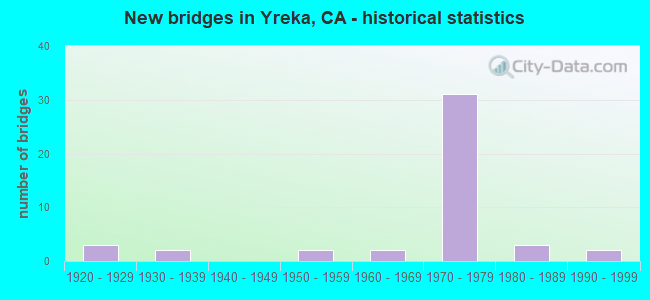
- New bridges - historical statistics
- 31920-1929
- 21930-1939
- 21950-1959
- 21960-1969
- 311970-1979
- 31980-1989
- 21990-1999


- Bridge Condition - Deck
- 84.8%Good
- 3.0%Satisfactory
- 9.1%Fair
- 3.0%Poor

- Bridge Condition - Superstructure
- 87.9%Good
- 3.0%Satisfactory
- 9.1%Fair

- Bridge Condition - Substructure
- 63.6%Good
- 24.2%Satisfactory
- 12.1%Fair

- Bridge Condition - Channel
- 40.0%Very good
- 32.0%Good
- 28.0%Satisfactory

- Bridge Condition - Culverts
- 66.7%Good
- 33.3%Fair
Find on map >> Show street view
Structure Number: 2 001, Location: 02-SIS-005-R46.05-YRE (Lat: 41.709786, Lng: -122.641492), Route carried "on" structure: Interstate 5, Year Built: 1970, Status: Open, Structure Length: 0.79m (2.59ft), Average Daily Traffic: 16,600 (year 2015), Truck Traffic: 25%, Average Future Daily Traffic: 23,951 (year 2042), Features Intersected: GREENHORN CREEK
Minimum Vertical Clearance: 30+ m (98+ ft), Kilometerpoint: 46.050, Lanes on structure: 4, Base Highway Network: Yes (, Subroute: 1), Owner: State Highway Agency, Approaching Roadway Width: 40.8m (133.9ft), Skew: 20 degrees, Material/Design: Concrete continuous, Design/Construction: Culvert, Number Of Spans In Main Unit: 2, Length of Maximum Span: 3.7m (12.1ft)
Condition: Channel: Satisfactory, Culverts: Good, Operating Rating: 54.1 metric tons, Method Used To Determine Operating Rating: Field evaluation and documented engineering judgment, Inventory Rating: 32.4 metric tons, Method Used To Determine Inventory Rating: Field evaluation and documented engineering judgment, Structural Evaluation: Better than present minimum criteria, Waterway Adequacy: Equal to present desirable criteria, Approach Roadway Alignment: Equal to present desirable criteria, Designated Inspection Frequency: Every 24 months, Inspection Date: September 2020
Find on map >> Show street view
Structure Number: 2 0011, Location: 02-SIS-263-52.62 (Lat: 41.781089, Lng: -122.596397), Route carried "on" structure: State highway 263, Year Built: 1928, Status: Open, Structure Length: 8.38m (27.49ft), Average Daily Traffic: 1,200 (year 2015), Truck Traffic: 10%, Average Future Daily Traffic: 1,850 (year 2040), Design Load: HS 15, Features Intersected: SHASTA RIVER
Minimum Vertical Clearance: 30+ m (98+ ft), Kilometerpoint: 52.620, Lanes on structure: 2, Base Highway Network: Yes, Owner: State Highway Agency, Approaching Roadway Width: 7.3m (24.0ft), Material/Design: Concrete, Design/Construction: Tee Beam, Number Of Spans In Main Unit: 5, Length of Maximum Span: 18.3m (60.0ft), Curb-To-Curb Width: 7.3m (24.0ft), Out-to-Out Width: 8.4m (27.6ft)
Condition: Deck: Good, Superstructure: Fair, Substructure: Fair, Channel: Satisfactory, Operating Rating: 55.4 metric tons, Method Used To Determine Operating Rating: Load Factor (LF), Inventory Rating: 33.4 metric tons, Method Used To Determine Inventory Rating: Load Factor (LF), Structural Evaluation: Somewhat better than minimum adequacy, Deck Geometry: Meets minimum limits, Waterway Adequacy: Better than present minimum criteria, Approach Roadway Alignment: Equal to present desirable criteria, Designated Inspection Frequency: Every 24 months, Inspection Date: September 2021, Deck Structure Type: Concrete Cast-file-Place, Wearing Surface/Protective System: Wearing Surface: Epoxy Overlay
Find on map >> Show street view
Structure Number: 2 0012, Location: 02-SIS-263-54.51 (Lat: 41.801950, Lng: -122.598758), Route carried "on" structure: State highway 263, Year Built: 1929, Status: Open, Structure Length: 10.52m (34.51ft), Average Daily Traffic: 1,200 (year 2015), Truck Traffic: 10%, Average Future Daily Traffic: 1,800 (year 2040), Design Load: HS 15, Features Intersected: DRY GULCH
Minimum Vertical Clearance: 30+ m (98+ ft), Kilometerpoint: 54.510, Lanes on structure: 2, Base Highway Network: Yes, Owner: State Highway Agency, Approaching Roadway Width: 7.3m (24.0ft), Skew: 9 degrees, Material/Design: Concrete, Design/Construction: Arch - Deck, Number Of Spans In Main Unit: 1, Number Of Approach Spans: 3, Length of Maximum Span: 61.7m (202.4ft), Curb-To-Curb Width: 7.3m (24.0ft), Out-to-Out Width: 8.4m (27.6ft)
Condition: Deck: Good, Superstructure: Fair, Substructure: Good, Channel: Very good, Operating Rating: 48.0 metric tons, Method Used To Determine Operating Rating: Load Factor (LF), Inventory Rating: 28.8 metric tons, Method Used To Determine Inventory Rating: Load Factor (LF), Structural Evaluation: Somewhat better than minimum adequacy, Deck Geometry: Meets minimum limits, Waterway Adequacy: Equal to present desirable criteria, Approach Roadway Alignment: Equal to present desirable criteria, Designated Inspection Frequency: Every 24 months, Inspection Date: September 2021, Deck Structure Type: Concrete Cast-file-Place, Wearing Surface/Protective System: Wearing Surface: Epoxy Overlay
Find on map >> Show street view
Structure Number: 2 0013, Location: 02-SIS-263-55.03 (Lat: 41.808353, Lng: -122.595625), Route carried "on" structure: State highway 263, Year Built: 1931, Status: Open, Structure Length: 24.20m (79.40ft), Average Daily Traffic: 1,200 (year 2015), Truck Traffic: 10%, Average Future Daily Traffic: 1,800 (year 2040), Design Load: HS 15, Features Intersected: SHASTA RIVER
Minimum Vertical Clearance: 30+ m (98+ ft), Kilometerpoint: 55.030, Lanes on structure: 2, Base Highway Network: Yes (Inventory Route: 2, Subroute: 1), Owner: State Highway Agency, Approaching Roadway Width: 7.3m (24.0ft), Material/Design: Steel continuous, Design/Construction: Truss - Deck, Number Of Spans In Main Unit: 3, Number Of Approach Spans: 2, Length of Maximum Span: 126.2m (414.0ft), Curb-To-Curb Width: 7.3m (24.0ft), Out-to-Out Width: 7.9m (25.9ft)
Condition: Deck: Good, Superstructure: Good, Substructure: Good, Channel: Very good, Operating Rating: 40.8 metric tons, Method Used To Determine Operating Rating: Load Factor (LF), Inventory Rating: 24.3 metric tons, Method Used To Determine Inventory Rating: Load Factor (LF), Structural Evaluation: Equal to present minimum criteria, Deck Geometry: Meets minimum limits, Waterway Adequacy: Equal to present desirable criteria, Approach Roadway Alignment: Equal to present desirable criteria, Designated Inspection Frequency: Every 24 months, Critical Feature Inspection Frequency: Every 24 months, Inspection Date: September 2021, Critical Feature Inspection Date: May 2020, Deck Structure Type: Concrete Cast-file-Place, Wearing Surface/Protective System: Wearing Surface: Epoxy Overlay
Find on map >> Show street view
Structure Number: 2 0014, Location: 02-SIS-263-56.35 (Lat: 41.821164, Lng: -122.592583), Route carried "on" structure: State highway 263, Year Built: 1931, Status: Open, Structure Length: 17.74m (58.20ft), Average Daily Traffic: 1,200 (year 2015), Truck Traffic: 10%, Average Future Daily Traffic: 1,800 (year 2040), Design Load: HS 15, Features Intersected: SHASTA RIVER
Minimum Vertical Clearance: 30+ m (98+ ft), Kilometerpoint: 56.350, Lanes on structure: 2, Base Highway Network: Yes, Owner: State Highway Agency, Approaching Roadway Width: 7.3m (24.0ft), Material/Design: Concrete continuous, Design/Construction: Arch - Deck, Number Of Spans In Main Unit: 2, Number Of Approach Spans: 4, Length of Maximum Span: 63.1m (207.0ft), Curb-To-Curb Width: 7.3m (24.0ft), Out-to-Out Width: 8.4m (27.6ft)
Condition: Deck: Good, Superstructure: Fair, Substructure: Good, Channel: Good, Operating Rating: 47.0 metric tons, Method Used To Determine Operating Rating: Load Factor (LF), Inventory Rating: 28.2 metric tons, Method Used To Determine Inventory Rating: Load Factor (LF), Structural Evaluation: Somewhat better than minimum adequacy, Deck Geometry: Meets minimum limits, Waterway Adequacy: Equal to present desirable criteria, Approach Roadway Alignment: Equal to present desirable criteria, Designated Inspection Frequency: Every 24 months, Inspection Date: September 2021, Deck Structure Type: Concrete Cast-file-Place, Wearing Surface/Protective System: Wearing Surface: Epoxy Overlay
Find on map >> Show street view
Structure Number: 2 0138L, Location: 02-SIS-005-R46.49-YRE (Lat: 41.715981, Lng: -122.639653), Route carried "on" structure: Interstate 5, Year Built: 1970, Status: Open, Structure Length: 3.54m (11.61ft), Average Daily Traffic: 8,300 (year 2020), Truck Traffic: 25%, Average Future Daily Traffic: 12,218 (year 2040), Design Load: HS 20, Features Intersected: OBERLIN ROAD
Minimum Vertical Clearance: 30+ m (98+ ft), Kilometerpoint: 46.490, Lanes on structure: 2, Lanes under structure: 3, Base Highway Network: Yes (, Subroute: 1), Owner: State Highway Agency, Approaching Roadway Width: 11.9m (39.0ft), Skew: 1 degrees, Material/Design: Prestressed concrete continuous, Design/Construction: Stringer/Multi-beam, Number Of Spans In Main Unit: 1, Number Of Approach Spans: 2, Length of Maximum Span: 20.7m (67.9ft), Curb-To-Curb Width: 11.9m (39.0ft), Out-to-Out Width: 12.5m (41.0ft)
Condition: Deck: Fair, Superstructure: Good, Substructure: Good, Operating Rating: 41.5 metric tons, Method Used To Determine Operating Rating: Load and Resistance Factor Rating (LRFR) rating reported by rating factor(RF) method using HL-93 loadings, Inventory Rating: 28.2 metric tons, Method Used To Determine Inventory Rating: Load and Resistance Factor Rating (LRFR) rating reported by rating factor(RF) method using HL-93 loadings, Structural Evaluation: Better than present minimum criteria, Deck Geometry: Equal to present minimum criteria, Underclear: Meets minimum limits, Approach Roadway Alignment: Equal to present desirable criteria, Designated Inspection Frequency: Every 24 months, Inspection Date: January 2022, Deck Structure Type: Concrete Cast-file-Place, Wearing Surface/Protective System: Wearing Surface: Integral Concrete
Find on map >> Show street view
Structure Number: 2 0138R, Location: 02-SIS-005-R46.49-YRE (Lat: 41.715942, Lng: -122.639375), Route carried "on" structure: Interstate 5, Year Built: 1970, Status: Open, Structure Length: 3.54m (11.61ft), Average Daily Traffic: 8,300 (year 2020), Truck Traffic: 25%, Average Future Daily Traffic: 12,218 (year 2040), Design Load: HS 20, Features Intersected: OBERLIN ROAD
Minimum Vertical Clearance: 30+ m (98+ ft), Kilometerpoint: 46.490, Lanes on structure: 2, Lanes under structure: 3, Base Highway Network: Yes (, Subroute: 1), Owner: State Highway Agency, Approaching Roadway Width: 11.9m (39.0ft), Skew: 1 degrees, Material/Design: Prestressed concrete continuous, Design/Construction: Stringer/Multi-beam, Number Of Spans In Main Unit: 1, Number Of Approach Spans: 2, Length of Maximum Span: 20.7m (67.9ft), Curb-To-Curb Width: 11.9m (39.0ft), Out-to-Out Width: 12.5m (41.0ft)
Condition: Deck: Fair, Superstructure: Good, Substructure: Good, Operating Rating: 41.5 metric tons, Method Used To Determine Operating Rating: Load and Resistance Factor Rating (LRFR) rating reported by rating factor(RF) method using HL-93 loadings, Inventory Rating: 28.2 metric tons, Method Used To Determine Inventory Rating: Load and Resistance Factor Rating (LRFR) rating reported by rating factor(RF) method using HL-93 loadings, Structural Evaluation: Better than present minimum criteria, Deck Geometry: Equal to present minimum criteria, Underclear: High priority of corrective action, Approach Roadway Alignment: Equal to present desirable criteria, Designated Inspection Frequency: Every 24 months, Inspection Date: January 2022, Deck Structure Type: Concrete Cast-file-Place, Wearing Surface/Protective System: Wearing Surface: Integral Concrete
Find on map >> Show street view
Structure Number: 2 0143, Location: 02-SIS-005-R46.79-YRE (Lat: 41.720008, Lng: -122.637603), Route carried "on" structure: Interstate 5, Year Built: 1970, Status: Open, Structure Length: 2.68m (8.79ft), Average Daily Traffic: 16,600 (year 2015), Truck Traffic: 25%, Average Future Daily Traffic: 23,951 (year 2042), Design Load: HS 20, Features Intersected: YREKA CREEK
Minimum Vertical Clearance: 30+ m (98+ ft), Kilometerpoint: 46.790, Lanes on structure: 4, Base Highway Network: Yes (, Subroute: 1), Owner: State Highway Agency, Approaching Roadway Width: 34.7m (113.8ft), Skew: 4 degrees, Material/Design: Concrete continuous, Design/Construction: Tee Beam, Number Of Spans In Main Unit: 2, Length of Maximum Span: 13.3m (43.6ft), Curb-To-Curb Width: 34.7m (113.8ft), Out-to-Out Width: 35.4m (116.1ft)
Condition: Deck: Good, Superstructure: Good, Substructure: Good, Channel: Very good, Operating Rating: 33.0 metric tons, Method Used To Determine Operating Rating: Load and Resistance Factor Rating (LRFR) rating reported by rating factor(RF) method using HL-93 loadings, Inventory Rating: 24.3 metric tons, Method Used To Determine Inventory Rating: Load and Resistance Factor Rating (LRFR) rating reported by rating factor(RF) method using HL-93 loadings, Structural Evaluation: Equal to present minimum criteria, Deck Geometry: Superior to present desirable criteria, Waterway Adequacy: Equal to present desirable criteria, Approach Roadway Alignment: Equal to present desirable criteria, Designated Inspection Frequency: Every 24 months, Inspection Date: September 2020, Deck Structure Type: Concrete Cast-file-Place, Wearing Surface/Protective System: Wearing Surface: Integral Concrete
Find on map >> Show street view
Structure Number: 2 0148L, Location: 02-SIS-005-R51.16 (Lat: 41.766814, Lng: -122.586389), Route carried "on" structure: Interstate 5, Year Built: 1970, Status: Open, Structure Length: 16.22m (53.22ft), Average Daily Traffic: 7,050 (year 2015), Truck Traffic: 32%, Average Future Daily Traffic: 10,270 (year 2040), Design Load: HS 20, Features Intersected: SHASTA RIVER
Minimum Vertical Clearance: 30+ m (98+ ft), Kilometerpoint: 51.160, Lanes on structure: 2, Base Highway Network: Yes (, Subroute: 1), Owner: State Highway Agency, Approaching Roadway Width: 11.9m (39.0ft), Material/Design: Prestressed concrete continuous, Design/Construction: Stringer/Multi-beam, Number Of Spans In Main Unit: 3, Length of Maximum Span: 61.0m (200.1ft), Curb-To-Curb Width: 11.9m (39.0ft), Out-to-Out Width: 12.7m (41.7ft)
Condition: Deck: Good, Superstructure: Good, Substructure: Satisfactory, Channel: Very good, Operating Rating: 44.4 metric tons, Method Used To Determine Operating Rating: Load and Resistance Factor Rating (LRFR) rating reported by rating factor(RF) method using HL-93 loadings, Inventory Rating: 28.8 metric tons, Method Used To Determine Inventory Rating: Load and Resistance Factor Rating (LRFR) rating reported by rating factor(RF) method using HL-93 loadings, Structural Evaluation: Equal to present minimum criteria, Deck Geometry: Equal to present minimum criteria, Waterway Adequacy: Equal to present desirable criteria, Approach Roadway Alignment: Equal to present desirable criteria, Designated Inspection Frequency: Every 24 months, Inspection Date: September 2021, Deck Structure Type: Concrete Cast-file-Place, Wearing Surface/Protective System: Wearing Surface: Integral Concrete, Deck Protection: Epoxy Coated Reinforcing
Find on map >> Show street view
Structure Number: 2 0148R, Location: 02-SIS-005-R51.16 (Lat: 41.766639, Lng: -122.586056), Route carried "on" structure: Interstate 5, Year Built: 1970, Status: Open, Structure Length: 16.22m (53.22ft), Average Daily Traffic: 7,050 (year 2015), Truck Traffic: 32%, Average Future Daily Traffic: 10,270 (year 2040), Design Load: HS 20, Features Intersected: SHASTA RIVER
Minimum Vertical Clearance: 30+ m (98+ ft), Kilometerpoint: 51.160, Lanes on structure: 2, Base Highway Network: Yes (, Subroute: 1), Owner: State Highway Agency, Approaching Roadway Width: 11.9m (39.0ft), Material/Design: Prestressed concrete continuous, Design/Construction: Stringer/Multi-beam, Number Of Spans In Main Unit: 3, Length of Maximum Span: 61.0m (200.1ft), Curb-To-Curb Width: 11.9m (39.0ft), Out-to-Out Width: 12.7m (41.7ft)
Condition: Deck: Good, Superstructure: Good, Substructure: Satisfactory, Channel: Very good, Operating Rating: 41.8 metric tons, Method Used To Determine Operating Rating: Load and Resistance Factor Rating (LRFR) rating reported by rating factor(RF) method using HL-93 loadings, Inventory Rating: 29.2 metric tons, Method Used To Determine Inventory Rating: Load and Resistance Factor Rating (LRFR) rating reported by rating factor(RF) method using HL-93 loadings, Structural Evaluation: Equal to present minimum criteria, Deck Geometry: Equal to present minimum criteria, Waterway Adequacy: Equal to present desirable criteria, Approach Roadway Alignment: Equal to present desirable criteria, Designated Inspection Frequency: Every 24 months, Inspection Date: September 2021, Deck Structure Type: Concrete Cast-file-Place, Wearing Surface/Protective System: Wearing Surface: Integral Concrete, Deck Protection: Epoxy Coated Reinforcing
Find on map >> Show street view
Structure Number: 2 0149, Location: 02-SIS-005-R44.31 (Lat: 41.685394, Lng: -122.635764), Route carried "on" structure: County highway , Year Built: 1970, Status: Open, Structure Length: 6.18m (20.28ft), Average Daily Traffic: 1,915 (year 2010), Truck Traffic: 2%, Average Future Daily Traffic: 3,173 (year 2042), Design Load: HS 20, Features Intersected: INTERSTATE 5, Facility Carried by Structure: WALTERS ROAD
Minimum Vertical Clearance: 30+ m (98+ ft), Kilometerpoint: 0.000, Lanes on structure: 2, Lanes under structure: 4, Base Highway Network: Yes, Owner: State Highway Agency, Approaching Roadway Width: 9.8m (32.2ft), Skew: 1 degrees, Material/Design: Prestressed concrete continuous, Design/Construction: Stringer/Multi-beam, Number Of Spans In Main Unit: 2, Length of Maximum Span: 31.4m (103.0ft), Curb-To-Curb Width: 9.8m (32.2ft), Out-to-Out Width: 10.4m (34.1ft)
Condition: Deck: Good, Superstructure: Good, Substructure: Good, Operating Rating: 70.3 metric tons, Method Used To Determine Operating Rating: Load Factor (LF), Inventory Rating: 32.4 metric tons, Method Used To Determine Inventory Rating: Load Factor (LF), Structural Evaluation: Better than present minimum criteria, Deck Geometry: Somewhat better than minimum adequacy, Underclear: Somewhat better than minimum adequacy, Approach Roadway Alignment: Better than present minimum criteria, Designated Inspection Frequency: Every 24 months, Inspection Date: July 2020, Deck Structure Type: Concrete Cast-file-Place, Wearing Surface/Protective System: Wearing Surface: Integral Concrete
Find on map >> Show street view
Structure Number: 2 0150L, Location: 02-SIS-005-R48.23-YRE (Lat: 41.739528, Lng: -122.628136), Route carried "on" structure: Interstate 5, Year Built: 1970, Status: Open, Structure Length: 3.80m (12.47ft), Average Daily Traffic: 8,300 (year 2010), Truck Traffic: 25%, Average Future Daily Traffic: 12,218 (year 2040), Design Load: HS 20+Mod, Features Intersected: STATE ROUTE 3
Minimum Vertical Clearance: 30+ m (98+ ft), Kilometerpoint: 48.230, Lanes on structure: 2, Lanes under structure: 3, Base Highway Network: Yes (, Subroute: 1), Owner: State Highway Agency, Approaching Roadway Width: 11.9m (39.0ft), Skew: 1 degrees, Material/Design: Prestressed concrete, Design/Construction: Box Beam or Girders - Multiple, Number Of Spans In Main Unit: 1, Length of Maximum Span: 38.0m (124.7ft), Curb-To-Curb Width: 11.9m (39.0ft), Out-to-Out Width: 12.5m (41.0ft)
Condition: Deck: Good, Superstructure: Good, Substructure: Satisfactory, Operating Rating: 39.5 metric tons, Method Used To Determine Operating Rating: Load and Resistance Factor Rating (LRFR) rating reported by rating factor(RF) method using HL-93 loadings, Inventory Rating: 25.6 metric tons, Method Used To Determine Inventory Rating: Load and Resistance Factor Rating (LRFR) rating reported by rating factor(RF) method using HL-93 loadings, Structural Evaluation: Equal to present minimum criteria, Deck Geometry: Equal to present minimum criteria, Underclear: Meets minimum limits, Approach Roadway Alignment: Equal to present desirable criteria, Designated Inspection Frequency: Every 24 months, Inspection Date: January 2022, Deck Structure Type: Concrete Cast-file-Place, Wearing Surface/Protective System: Wearing Surface: Integral Concrete
Find on map >> Show street view
Structure Number: 2 0150R, Location: 02-SIS-005-R48.23-YRE (Lat: 41.739375, Lng: -122.627708), Route carried "on" structure: Interstate 5, Year Built: 1970, Status: Open, Structure Length: 3.80m (12.47ft), Average Daily Traffic: 8,300 (year 2010), Truck Traffic: 25%, Average Future Daily Traffic: 12,218 (year 2040), Design Load: HS 20, Features Intersected: STATE ROUTE 3
Minimum Vertical Clearance: 30+ m (98+ ft), Kilometerpoint: 48.230, Lanes on structure: 2, Lanes under structure: 3, Base Highway Network: Yes (, Subroute: 1), Owner: State Highway Agency, Approaching Roadway Width: 11.9m (39.0ft), Skew: 1 degrees, Material/Design: Prestressed concrete, Design/Construction: Box Beam or Girders - Multiple, Number Of Spans In Main Unit: 1, Length of Maximum Span: 38.0m (124.7ft), Curb-To-Curb Width: 11.9m (39.0ft), Out-to-Out Width: 12.5m (41.0ft)
Condition: Deck: Good, Superstructure: Good, Substructure: Satisfactory, Operating Rating: 41.5 metric tons, Method Used To Determine Operating Rating: Load and Resistance Factor Rating (LRFR) rating reported by rating factor(RF) method using HL-93 loadings, Inventory Rating: 26.2 metric tons, Method Used To Determine Inventory Rating: Load and Resistance Factor Rating (LRFR) rating reported by rating factor(RF) method using HL-93 loadings, Structural Evaluation: Equal to present minimum criteria, Deck Geometry: Equal to present minimum criteria, Underclear: Somewhat better than minimum adequacy, Approach Roadway Alignment: Equal to present desirable criteria, Designated Inspection Frequency: Every 24 months, Inspection Date: January 2022, Deck Structure Type: Concrete Cast-file-Place, Wearing Surface/Protective System: Wearing Surface: Integral Concrete
Find on map >> Show street view
Structure Number: 2 0151, Location: 02-SIS-003-L49.99-YRE (Lat: 41.740008, Lng: -122.630933), Route carried "on" structure: State highway 3, Year Built: 1970, Status: Open, Structure Length: 3.32m (10.89ft), Average Daily Traffic: 10,100 (year 2010), Truck Traffic: 2%, Average Future Daily Traffic: 11,976 (year 2042), Design Load: HS 20, Features Intersected: YREKA CREEK
Minimum Vertical Clearance: 30+ m (98+ ft), Kilometerpoint: 49.990, Lanes on structure: 4, Base Highway Network: Yes (, Subroute: 1), Owner: State Highway Agency, Approaching Roadway Width: 19.5m (64.0ft), Material/Design: Concrete continuous, Design/Construction: Tee Beam, Number Of Spans In Main Unit: 3, Length of Maximum Span: 13.1m (43.0ft), Curb-To-Curb Width: 19.5m (64.0ft), Out-to-Out Width: 20.1m (65.9ft)
Condition: Deck: Good, Superstructure: Good, Substructure: Good, Channel: Good, Operating Rating: 41.5 metric tons, Method Used To Determine Operating Rating: Load and Resistance Factor Rating (LRFR) rating reported by rating factor(RF) method using HL-93 loadings, Inventory Rating: 32.1 metric tons, Method Used To Determine Inventory Rating: Load and Resistance Factor Rating (LRFR) rating reported by rating factor(RF) method using HL-93 loadings, Structural Evaluation: Better than present minimum criteria, Deck Geometry: Better than present minimum criteria, Waterway Adequacy: Equal to present desirable criteria, Approach Roadway Alignment: Equal to present desirable criteria, Designated Inspection Frequency: Every 48 months, Inspection Date: September 2020, Deck Structure Type: Concrete Cast-file-Place, Wearing Surface/Protective System: Wearing Surface: Integral Concrete
Find on map >> Show street view
Structure Number: 2 0153L, Location: 02-SIS-005-R42.51 (Lat: 41.667717, Lng: -122.610364), Route carried "on" structure: Interstate 5, Year Built: 1970, Status: Open, Structure Length: 2.80m (9.19ft), Average Daily Traffic: 8,550 (year 2010), Truck Traffic: 24%, Average Future Daily Traffic: 12,283 (year 2042), Design Load: HS 20, Features Intersected: KILLGORE HILLS ROAD
Minimum Vertical Clearance: 30+ m (98+ ft), Kilometerpoint: 42.510, Lanes on structure: 2, Lanes under structure: 2, Base Highway Network: Yes (, Subroute: 1), Owner: State Highway Agency, Approaching Roadway Width: 11.9m (39.0ft), Material/Design: Prestressed concrete, Design/Construction: Box Beam or Girders - Multiple, Number Of Spans In Main Unit: 1, Length of Maximum Span: 27.3m (89.6ft), Curb-To-Curb Width: 11.9m (39.0ft), Out-to-Out Width: 12.5m (41.0ft)
Condition: Deck: Good, Superstructure: Good, Substructure: Good, Operating Rating: 39.9 metric tons, Method Used To Determine Operating Rating: Load and Resistance Factor Rating (LRFR) rating reported by rating factor(RF) method using HL-93 loadings, Inventory Rating: 26.2 metric tons, Method Used To Determine Inventory Rating: Load and Resistance Factor Rating (LRFR) rating reported by rating factor(RF) method using HL-93 loadings, Structural Evaluation: Equal to present minimum criteria, Deck Geometry: Equal to present minimum criteria, Underclear: Meets minimum limits, Approach Roadway Alignment: Equal to present desirable criteria, Designated Inspection Frequency: Every 24 months, Inspection Date: July 2020, Deck Structure Type: Concrete Cast-file-Place, Wearing Surface/Protective System: Wearing Surface: Integral Concrete
Find on map >> Show street view
Structure Number: 2 0153R, Location: 02-SIS-005-R42.51 (Lat: 41.667931, Lng: -122.610139), Route carried "on" structure: Interstate 5, Year Built: 1970, Status: Open, Structure Length: 2.80m (9.19ft), Average Daily Traffic: 8,550 (year 2010), Truck Traffic: 24%, Average Future Daily Traffic: 12,283 (year 2042), Design Load: HS 20, Features Intersected: KILLGORE HILLS ROAD
Minimum Vertical Clearance: 30+ m (98+ ft), Kilometerpoint: 42.510, Lanes on structure: 2, Lanes under structure: 2, Base Highway Network: Yes (, Subroute: 1), Owner: State Highway Agency, Approaching Roadway Width: 11.9m (39.0ft), Material/Design: Prestressed concrete, Design/Construction: Box Beam or Girders - Multiple, Number Of Spans In Main Unit: 1, Length of Maximum Span: 27.3m (89.6ft), Curb-To-Curb Width: 11.9m (39.0ft), Out-to-Out Width: 12.5m (41.0ft)
Condition: Deck: Good, Superstructure: Good, Substructure: Good, Operating Rating: 39.9 metric tons, Method Used To Determine Operating Rating: Load and Resistance Factor Rating (LRFR) rating reported by rating factor(RF) method using HL-93 loadings, Inventory Rating: 26.2 metric tons, Method Used To Determine Inventory Rating: Load and Resistance Factor Rating (LRFR) rating reported by rating factor(RF) method using HL-93 loadings, Structural Evaluation: Equal to present minimum criteria, Deck Geometry: Equal to present minimum criteria, Underclear: Meets minimum limits, Approach Roadway Alignment: Equal to present desirable criteria, Designated Inspection Frequency: Every 24 months, Inspection Date: July 2020, Deck Structure Type: Concrete Cast-file-Place, Wearing Surface/Protective System: Wearing Surface: Integral Concrete
Find on map >> Show street view
Structure Number: 2 0158L, Location: 02-SIS-005-R47.56-YRE (Lat: 41.730722, Lng: -122.633175), Route carried "on" structure: Interstate 5, Year Built: 1970, Status: Open, Structure Length: 3.56m (11.68ft), Average Daily Traffic: 8,300 (year 2015), Truck Traffic: 25%, Average Future Daily Traffic: 12,218 (year 2040), Design Load: HS 20, Features Intersected: MINER STREET
Minimum Vertical Clearance: 30+ m (98+ ft), Kilometerpoint: 47.560, Lanes on structure: 2, Lanes under structure: 3, Base Highway Network: Yes (, Subroute: 1), Owner: State Highway Agency, Approaching Roadway Width: 11.9m (39.0ft), Skew: 1 degrees, Material/Design: Prestressed concrete, Design/Construction: Box Beam or Girders - Multiple, Number Of Spans In Main Unit: 1, Length of Maximum Span: 35.6m (116.8ft), Curb-To-Curb Width: 11.9m (39.0ft), Out-to-Out Width: 12.5m (41.0ft)
Condition: Deck: Good, Superstructure: Good, Substructure: Fair, Operating Rating: 49.9 metric tons, Method Used To Determine Operating Rating: Load and Resistance Factor Rating (LRFR) rating reported by rating factor(RF) method using HL-93 loadings, Inventory Rating: 29.2 metric tons, Method Used To Determine Inventory Rating: Load and Resistance Factor Rating (LRFR) rating reported by rating factor(RF) method using HL-93 loadings, Structural Evaluation: Somewhat better than minimum adequacy, Deck Geometry: Equal to present minimum criteria, Underclear: Meets minimum limits, Approach Roadway Alignment: Equal to present desirable criteria, Designated Inspection Frequency: Every 24 months, Inspection Date: January 2022, Deck Structure Type: Concrete Cast-file-Place, Wearing Surface/Protective System: Wearing Surface: Integral Concrete
Find on map >> Show street view
Structure Number: 2 0158R, Location: 02-SIS-005-R47.56-YRE (Lat: 41.730689, Lng: -122.632903), Route carried "on" structure: Interstate 5, Year Built: 1970, Status: Open, Structure Length: 3.56m (11.68ft), Average Daily Traffic: 8,300 (year 2015), Truck Traffic: 25%, Average Future Daily Traffic: 12,218 (year 2040), Design Load: HS 20, Features Intersected: MINER STREET
Minimum Vertical Clearance: 30+ m (98+ ft), Kilometerpoint: 47.560, Lanes on structure: 2, Lanes under structure: 3, Base Highway Network: Yes (, Subroute: 1), Owner: State Highway Agency, Approaching Roadway Width: 11.9m (39.0ft), Skew: 1 degrees, Material/Design: Prestressed concrete, Design/Construction: Box Beam or Girders - Multiple, Number Of Spans In Main Unit: 1, Length of Maximum Span: 35.6m (116.8ft), Curb-To-Curb Width: 11.9m (39.0ft), Out-to-Out Width: 12.5m (41.0ft)
Condition: Deck: Good, Superstructure: Good, Substructure: Fair, Operating Rating: 50.2 metric tons, Method Used To Determine Operating Rating: Load and Resistance Factor Rating (LRFR) rating reported by rating factor(RF) method using HL-93 loadings, Inventory Rating: 29.5 metric tons, Method Used To Determine Inventory Rating: Load and Resistance Factor Rating (LRFR) rating reported by rating factor(RF) method using HL-93 loadings, Structural Evaluation: Somewhat better than minimum adequacy, Deck Geometry: Equal to present minimum criteria, Underclear: Somewhat better than minimum adequacy, Approach Roadway Alignment: Equal to present desirable criteria, Designated Inspection Frequency: Every 24 months, Inspection Date: January 2022, Deck Structure Type: Concrete Cast-file-Place, Wearing Surface/Protective System: Wearing Surface: Integral Concrete
Find on map >> Show street view
Structure Number: 2 0159L, Location: 02-SIS-005-R45.62-YRE (Lat: 41.703800, Lng: -122.643053), Route carried "on" structure: Interstate 5, Year Built: 1970, Status: Open, Structure Length: 3.40m (11.15ft), Average Daily Traffic: 8,300 (year 2020), Truck Traffic: 25%, Average Future Daily Traffic: 12,218 (year 2040), Design Load: HS 20, Features Intersected: MOONLIT OAKS AVE
Minimum Vertical Clearance: 30+ m (98+ ft), Kilometerpoint: 45.620, Lanes on structure: 2, Lanes under structure: 3, Base Highway Network: Yes (, Subroute: 1), Owner: State Highway Agency, Approaching Roadway Width: 11.9m (39.0ft), Skew: 9 degrees, Material/Design: Prestressed concrete, Design/Construction: Box Beam or Girders - Multiple, Number Of Spans In Main Unit: 1, Length of Maximum Span: 34.0m (111.5ft), Curb-To-Curb Width: 11.9m (39.0ft), Out-to-Out Width: 12.5m (41.0ft)
Condition: Deck: Good, Superstructure: Good, Substructure: Satisfactory, Operating Rating: 43.7 metric tons, Method Used To Determine Operating Rating: Load and Resistance Factor Rating (LRFR) rating reported by rating factor(RF) method using HL-93 loadings, Inventory Rating: 29.5 metric tons, Method Used To Determine Inventory Rating: Load and Resistance Factor Rating (LRFR) rating reported by rating factor(RF) method using HL-93 loadings, Structural Evaluation: Equal to present minimum criteria, Deck Geometry: Equal to present minimum criteria, Underclear: High priority of corrective action, Approach Roadway Alignment: Equal to present desirable criteria, Designated Inspection Frequency: Every 24 months, Inspection Date: January 2022, Deck Structure Type: Concrete Cast-file-Place, Wearing Surface/Protective System: Wearing Surface: Integral Concrete
Find on map >> Show street view
Structure Number: 2 0159R, Location: 02-SIS-005-R45.62-YRE (Lat: 41.703828, Lng: -122.642703), Route carried "on" structure: Interstate 5, Year Built: 1970, Status: Open, Structure Length: 3.40m (11.15ft), Average Daily Traffic: 8,300 (year 2020), Truck Traffic: 25%, Average Future Daily Traffic: 12,218 (year 2040), Design Load: HS 20, Features Intersected: MOONLIT OAKS AVE
Minimum Vertical Clearance: 30+ m (98+ ft), Kilometerpoint: 45.620, Lanes on structure: 2, Lanes under structure: 3, Base Highway Network: Yes (, Subroute: 1), Owner: State Highway Agency, Approaching Roadway Width: 11.9m (39.0ft), Skew: 9 degrees, Material/Design: Prestressed concrete, Design/Construction: Box Beam or Girders - Multiple, Number Of Spans In Main Unit: 1, Length of Maximum Span: 34.0m (111.5ft), Curb-To-Curb Width: 11.9m (39.0ft), Out-to-Out Width: 12.5m (41.0ft)
Condition: Deck: Good, Superstructure: Good, Substructure: Satisfactory, Operating Rating: 43.7 metric tons, Method Used To Determine Operating Rating: Load and Resistance Factor Rating (LRFR) rating reported by rating factor(RF) method using HL-93 loadings, Inventory Rating: 29.5 metric tons, Method Used To Determine Inventory Rating: Load and Resistance Factor Rating (LRFR) rating reported by rating factor(RF) method using HL-93 loadings, Structural Evaluation: Equal to present minimum criteria, Deck Geometry: Equal to present minimum criteria, Underclear: Meets minimum limits, Approach Roadway Alignment: Equal to present desirable criteria, Designated Inspection Frequency: Every 24 months, Inspection Date: January 2022, Deck Structure Type: Concrete Cast-file-Place, Wearing Surface/Protective System: Wearing Surface: Integral Concrete
Find on map >> Show street view
Structure Number: 2 016, Location: 02-SIS-005-R45.61-YRE (Lat: 41.703497, Lng: -122.642636), Route carried "on" structure: Interstate 5, Year Built: 1970, Status: Open, Structure Length: 1.55m (5.09ft), Average Daily Traffic: 16,600 (year 2015), Truck Traffic: 25%, Average Future Daily Traffic: 23,951 (year 2042), Features Intersected: YREKA CREEK
Minimum Vertical Clearance: 30+ m (98+ ft), Kilometerpoint: 45.610, Lanes on structure: 4, Base Highway Network: Yes (, Subroute: 1), Owner: State Highway Agency, Approaching Roadway Width: 43.6m (143.0ft), Skew: 23 degrees, Material/Design: Concrete continuous, Design/Construction: Culvert, Number Of Spans In Main Unit: 2, Length of Maximum Span: 6.1m (20.0ft)
Condition: Channel: Satisfactory, Culverts: Good, Operating Rating: 54.1 metric tons, Method Used To Determine Operating Rating: Field evaluation and documented engineering judgment, Inventory Rating: 32.4 metric tons, Method Used To Determine Inventory Rating: Field evaluation and documented engineering judgment, Structural Evaluation: Better than present minimum criteria, Waterway Adequacy: Better than present minimum criteria, Approach Roadway Alignment: Equal to present desirable criteria, Designated Inspection Frequency: Every 24 months, Inspection Date: September 2020
Find on map >> Show street view
Structure Number: 2C0022, Location: EAST OF HEARN CENTER (Lat: 41.730789, Lng: -122.634089), Route carried "on" structure: City street , Year Built: 1970, Status: Open, Structure Length: 1.88m (6.17ft), Average Daily Traffic: 1,328 (year 2011), Truck Traffic: 5%, Average Future Daily Traffic: 2,532 (year 2042), Design Load: HS 20, Features Intersected: YREKA CREEK, Facility Carried by Structure: FOOTHILL DRIVE
Minimum Vertical Clearance: 30+ m (98+ ft), Kilometerpoint: 0.000, Lanes on structure: 4, Owner: City or Municipal Highway Agency, Approaching Roadway Width: 9.8m (32.2ft), Skew: 29 degrees, Material/Design: Concrete continuous, Design/Construction: Slab, Number Of Spans In Main Unit: 2, Length of Maximum Span: 9.1m (29.9ft), Curb or Sidewalk Widths: Left: 1.5m (4.9ft), Right: 1.8m (5.9ft), Curb-To-Curb Width: 18.6m (61.0ft), Out-to-Out Width: 22.5m (73.8ft)
Condition: Deck: Good, Superstructure: Good, Substructure: Good, Channel: Very good, Operating Rating: 41.5 metric tons, Method Used To Determine Operating Rating: Load and Resistance Factor Rating (LRFR) rating reported by rating factor(RF) method using HL-93 loadings, Inventory Rating: 32.1 metric tons, Method Used To Determine Inventory Rating: Load and Resistance Factor Rating (LRFR) rating reported by rating factor(RF) method using HL-93 loadings, Structural Evaluation: Better than present minimum criteria, Deck Geometry: Equal to present minimum criteria, Waterway Adequacy: Superior to present desirable criteria, Approach Roadway Alignment: Equal to present minimum criteria, Designated Inspection Frequency: Every 48 months, Inspection Date: June 2020, Deck Structure Type: Concrete Cast-file-Place, Wearing Surface/Protective System: Wearing Surface: Bituminous
Find on map >> Show street view
Structure Number: 2C0035, Location: 1.25 MI NE OF SR 3 (Lat: 41.746106, Lng: -122.574500), Route carried "on" structure: County highway , Year Built: 1969, Status: Open, Structure Length: 5.18m (16.99ft), Average Daily Traffic: 536 (year 2011), Truck Traffic: 5%, Average Future Daily Traffic: 762 (year 2040), Design Load: HS 20, Features Intersected: SHASTA RIVER, Facility Carried by Structure: YREKA AGER RD
Minimum Vertical Clearance: 30+ m (98+ ft), Kilometerpoint: 0.000, Lanes on structure: 2, Owner: County Highway Agency, Approaching Roadway Width: 7.3m (24.0ft), Skew: 2 degrees, Material/Design: Concrete continuous, Design/Construction: Tee Beam, Number Of Spans In Main Unit: 3, Length of Maximum Span: 20.4m (66.9ft), Curb-To-Curb Width: 8.5m (27.9ft), Out-to-Out Width: 8.7m (28.5ft)
Condition: Deck: Good, Superstructure: Good, Substructure: Good, Channel: Very good, Operating Rating: 46.3 metric tons, Method Used To Determine Operating Rating: Load and Resistance Factor Rating (LRFR) rating reported by rating factor(RF) method using HL-93 loadings, Inventory Rating: 35.6 metric tons, Method Used To Determine Inventory Rating: Load and Resistance Factor Rating (LRFR) rating reported by rating factor(RF) method using HL-93 loadings, Structural Evaluation: Better than present minimum criteria, Deck Geometry: Somewhat better than minimum adequacy, Waterway Adequacy: Better than present minimum criteria, Approach Roadway Alignment: Equal to present minimum criteria, Designated Inspection Frequency: Every 48 months, Inspection Date: August 2018, Deck Structure Type: Concrete Cast-file-Place, Wearing Surface/Protective System: Wearing Surface: Bituminous, Membrane: Preformed Fabric
Find on map >> Show street view
Structure Number: 2C0042, Location: 0.1 MI E/O FAIRLANE RD (Lat: 41.715767, Lng: -122.636386), Route carried "on" structure: City street , Year Built: 1959, Status: Open, Structure Length: 2.45m (8.04ft), Average Daily Traffic: 1,839 (year 2011), Truck Traffic: 10%, Average Future Daily Traffic: 3,314 (year 2040), Design Load: H 20, Features Intersected: YREKA CREEK, Facility Carried by Structure: OBERLIN RD (YREKA)
Minimum Vertical Clearance: 30+ m (98+ ft), Kilometerpoint: 0.000, Lanes on structure: 2, Owner: City or Municipal Highway Agency, Approaching Roadway Width: 11.9m (39.0ft), Material/Design: Concrete continuous, Design/Construction: Slab, Number Of Spans In Main Unit: 3, Length of Maximum Span: 7.9m (25.9ft), Curb-To-Curb Width: 9.8m (32.2ft), Out-to-Out Width: 10.0m (32.8ft)
Condition: Deck: Good, Superstructure: Good, Substructure: Good, Channel: Good, Operating Rating: 58.3 metric tons, Method Used To Determine Operating Rating: Load Factor (LF), Inventory Rating: 35.0 metric tons, Method Used To Determine Inventory Rating: Load Factor (LF), Structural Evaluation: Better than present minimum criteria, Deck Geometry: Somewhat better than minimum adequacy, Waterway Adequacy: Better than present minimum criteria, Approach Roadway Alignment: Equal to present desirable criteria, Designated Inspection Frequency: Every 48 months, Inspection Date: June 2018, Deck Structure Type: Concrete Cast-file-Place, Wearing Surface/Protective System: Wearing Surface: Bituminous
Find on map >> Show street view
Structure Number: 2C0083, Location: 0.1 MI E OF SR 263 (Lat: 41.771944, Lng: -122.604458), Route carried "on" structure: County highway , Year Built: 1971, Status: Open, Structure Length: 2.74m (8.99ft), Average Daily Traffic: 90 (year 2011), Truck Traffic: 5%, Average Future Daily Traffic: 120 (year 2040), Design Load: HS 20, Features Intersected: YREKA CREEK, Facility Carried by Structure: ANDERSON GRADE RD
Minimum Vertical Clearance: 30+ m (98+ ft), Kilometerpoint: 0.000, Lanes on structure: 2, Owner: County Highway Agency, Approaching Roadway Width: 7.0m (23.0ft), Material/Design: Concrete continuous, Design/Construction: Tee Beam, Number Of Spans In Main Unit: 2, Length of Maximum Span: 13.4m (44.0ft), Curb-To-Curb Width: 8.5m (27.9ft), Out-to-Out Width: 8.7m (28.5ft)
Condition: Deck: Good, Superstructure: Good, Substructure: Good, Channel: Good, Operating Rating: 73.2 metric tons, Method Used To Determine Operating Rating: Load and Resistance Factor Rating (LRFR) rating reported by rating factor(RF) method using HL-93 loadings, Inventory Rating: 56.7 metric tons, Method Used To Determine Inventory Rating: Load and Resistance Factor Rating (LRFR) rating reported by rating factor(RF) method using HL-93 loadings, Structural Evaluation: Better than present minimum criteria, Deck Geometry: Better than present minimum criteria, Waterway Adequacy: Equal to present desirable criteria, Approach Roadway Alignment: Equal to present minimum criteria, Designated Inspection Frequency: Every 48 months, Inspection Date: August 2018, Deck Structure Type: Concrete Cast-file-Place, Wearing Surface/Protective System: Wearing Surface: Bituminous, Membrane: Preformed Fabric
Find on map >> Show street view
Structure Number: 2C0111, Location: 0.3 MI S OF WALTERS LN (Lat: 41.685992, Lng: -122.632822), Route carried "on" structure: County highway , Year Built: 1923, Status: Open, Structure Length: 0.67m (2.20ft), Average Daily Traffic: 171 (year 2011), Truck Traffic: 10%, Average Future Daily Traffic: 227 (year 2040), Features Intersected: JUNIPER CREEK, Facility Carried by Structure: FAIRLANE RD
Minimum Vertical Clearance: 30+ m (98+ ft), Kilometerpoint: 0.000, Lanes on structure: 2, Owner: County Highway Agency, Approaching Roadway Width: 5.8m (19.0ft), Material/Design: Concrete continuous, Design/Construction: Culvert, Number Of Spans In Main Unit: 3, Length of Maximum Span: 1.8m (5.9ft), Curb or Sidewalk Widths: Left: 0.1m (0.3ft), Right: 0.1m (0.3ft), Curb-To-Curb Width: 8.8m (28.9ft), Out-to-Out Width: 9.8m (32.2ft)
Condition: Channel: Very good, Culverts: Fair, Operating Rating: 26.9 metric tons, Method Used To Determine Operating Rating: Field evaluation and documented engineering judgment, Inventory Rating: 16.2 metric tons, Method Used To Determine Inventory Rating: Field evaluation and documented engineering judgment, Structural Evaluation: Somewhat better than minimum adequacy, Deck Geometry: Equal to present minimum criteria, Waterway Adequacy: Equal to present minimum criteria, Approach Roadway Alignment: Equal to present desirable criteria, Designated Inspection Frequency: Every 24 months, Inspection Date: June 2020
Find on map >> Show street view
Structure Number: 2C0149, Location: 0.3 MI S/O SHARPS RD (Lat: 41.705497, Lng: -122.641703), Route carried "on" structure: City street , Year Built: 1970, Status: Open, Structure Length: 5.27m (17.29ft), Average Daily Traffic: 1,081 (year 2011), Truck Traffic: 5%, Average Future Daily Traffic: 3,314 (year 2040), Design Load: HS 20+Mod, Features Intersected: YREKA CREEK, Facility Carried by Structure: FAIRLANE ROAD
Minimum Vertical Clearance: 30+ m (98+ ft), Kilometerpoint: 0.000, Lanes on structure: 2, Owner: City or Municipal Highway Agency, Approaching Roadway Width: 12.2m (40.0ft), Skew: 6 degrees, Material/Design: Concrete continuous, Design/Construction: Tee Beam, Number Of Spans In Main Unit: 3, Length of Maximum Span: 17.2m (56.4ft), Curb-To-Curb Width: 12.2m (40.0ft), Out-to-Out Width: 12.8m (42.0ft)
Condition: Deck: Fair, Superstructure: Good, Substructure: Good, Channel: Satisfactory, Operating Rating: 29.2 metric tons, Method Used To Determine Operating Rating: Load and Resistance Factor Rating (LRFR) rating reported by rating factor(RF) method using HL-93 loadings, Inventory Rating: 22.4 metric tons, Method Used To Determine Inventory Rating: Load and Resistance Factor Rating (LRFR) rating reported by rating factor(RF) method using HL-93 loadings, Structural Evaluation: Somewhat better than minimum adequacy, Deck Geometry: Better than present minimum criteria, Waterway Adequacy: Better than present minimum criteria, Approach Roadway Alignment: Equal to present minimum criteria, Designated Inspection Frequency: Every 24 months, Inspection Date: June 2020, Deck Structure Type: Concrete Cast-file-Place, Wearing Surface/Protective System: Wearing Surface: Bituminous
Find on map >> Show street view
Structure Number: 2C0221, Location: SOUTH HUMBUG CREEK RD (Lat: 41.793069, Lng: -122.693069), Route carried "on" structure: County highway , Year Built: 1971, Status: Open, Structure Length: 1.62m (5.31ft), Average Daily Traffic: 20 (year 2011), Truck Traffic: 5%, Average Future Daily Traffic: 28 (year 2040), Design Load: HS 20, Features Intersected: HUMBUG CREEK, Facility Carried by Structure: HAWKINSVLE HUMB RD
Minimum Vertical Clearance: 30+ m (98+ ft), Kilometerpoint: 0.000, Lanes on structure: 2, Owner: County Highway Agency, Approaching Roadway Width: 4.3m (14.1ft), Skew: 9 degrees, Material/Design: Concrete, Design/Construction: Tee Beam, Number Of Spans In Main Unit: 1, Length of Maximum Span: 15.8m (51.8ft), Curb-To-Curb Width: 6.1m (20.0ft), Out-to-Out Width: 6.3m (20.7ft)
Condition: Deck: Satisfactory, Superstructure: Good, Substructure: Good, Channel: Good, Operating Rating: 53.5 metric tons, Method Used To Determine Operating Rating: Load and Resistance Factor Rating (LRFR) rating reported by rating factor(RF) method using HL-93 loadings, Inventory Rating: 41.5 metric tons, Method Used To Determine Inventory Rating: Load and Resistance Factor Rating (LRFR) rating reported by rating factor(RF) method using HL-93 loadings, Structural Evaluation: Better than present minimum criteria, Deck Geometry: Somewhat better than minimum adequacy, Waterway Adequacy: Better than present minimum criteria, Approach Roadway Alignment: Better than present minimum criteria, Designated Inspection Frequency: Every 48 months, Inspection Date: July 2020, Deck Structure Type: Concrete Cast-file-Place
Find on map >> Show street view
Structure Number: 2C0225, Location: 0.1 MI E/O SR 3 (Lat: 41.735600, Lng: -122.632442), Route carried "on" structure: City street , Year Built: 1953, Status: Open, Structure Length: 2.29m (7.51ft), Average Daily Traffic: 4 (year 2011), Average Future Daily Traffic: 11 (year 2042), Design Load: HS 20, Features Intersected: YREKA CREEK, Facility Carried by Structure: E LENNOX ST
Minimum Vertical Clearance: 30+ m (98+ ft), Kilometerpoint: 0.000, Lanes on structure: 2, Owner: City or Municipal Highway Agency, Approaching Roadway Width: 12.2m (40.0ft), Material/Design: Concrete continuous, Design/Construction: Slab, Number Of Spans In Main Unit: 3, Length of Maximum Span: 9.4m (30.8ft), Curb or Sidewalk Widths: Left: 0.6m (2.0ft), Right: 1.6m (5.2ft), Curb-To-Curb Width: 12.2m (40.0ft), Out-to-Out Width: 14.6m (47.9ft)
Condition: Deck: Good, Superstructure: Good, Substructure: Satisfactory, Channel: Good, Operating Rating: 41.1 metric tons, Method Used To Determine Operating Rating: Load and Resistance Factor Rating (LRFR) rating reported by rating factor(RF) method using HL-93 loadings, Inventory Rating: 31.8 metric tons, Method Used To Determine Inventory Rating: Load and Resistance Factor Rating (LRFR) rating reported by rating factor(RF) method using HL-93 loadings, Structural Evaluation: Equal to present minimum criteria, Deck Geometry: Superior to present desirable criteria, Waterway Adequacy: Better than present minimum criteria, Approach Roadway Alignment: Equal to present desirable criteria, Designated Inspection Frequency: Every 24 months, Inspection Date: June 2020, Deck Structure Type: Concrete Cast-file-Place, Wearing Surface/Protective System: Wearing Surface: Bituminous
Find on map >> Show street view
Structure Number: 2C0236, Location: 0.8 MI E SH 263 (Lat: 41.772031, Lng: -122.593353), Route carried "on" structure: County highway , Year Built: 1982, Status: Open, Structure Length: 4.75m (15.58ft), Average Daily Traffic: 61 (year 2011), Truck Traffic: 5%, Average Future Daily Traffic: 88 (year 2040), Design Load: HS 20+Mod, Features Intersected: SHASTA RIVER, Facility Carried by Structure: ANDERSON GRADE RD
Minimum Vertical Clearance: 30+ m (98+ ft), Kilometerpoint: 0.000, Lanes on structure: 2, Owner: County Highway Agency, Approaching Roadway Width: 8.5m (27.9ft), Material/Design: Concrete continuous, Design/Construction: Box Beam or Girders - Multiple, Number Of Spans In Main Unit: 2, Length of Maximum Span: 23.8m (78.1ft), Curb-To-Curb Width: 8.5m (27.9ft), Out-to-Out Width: 8.7m (28.5ft)
Condition: Deck: Good, Superstructure: Good, Substructure: Good, Channel: Good, Operating Rating: 54.1 metric tons, Method Used To Determine Operating Rating: Assigned rating based on Load Factor Design (LFD) reported in metric tons, Inventory Rating: 32.4 metric tons, Method Used To Determine Inventory Rating: Assigned rating based on Load Factor Design (LFD) reported in metric tons, Structural Evaluation: Better than present minimum criteria, Deck Geometry: Better than present minimum criteria, Waterway Adequacy: Better than present minimum criteria, Approach Roadway Alignment: Equal to present minimum criteria, Designated Inspection Frequency: Every 48 months, Inspection Date: August 2018, Deck Structure Type: Concrete Cast-file-Place, Wearing Surface/Protective System: Wearing Surface: Bituminous, Membrane: Preformed Fabric
Find on map >> Show street view
Structure Number: 2C0239, Location: BEHIND COUNTY HOSPITAL (Lat: 41.724678, Lng: -122.637700), Route carried "on" structure: City street , Year Built: 1987, Status: Posted for load, Structure Length: 0.79m (2.59ft), Average Daily Traffic: 200 (year 2011), Truck Traffic: 2%, Average Future Daily Traffic: 270 (year 2038), Features Intersected: YREKA CREEK, Facility Carried by Structure: HOSPITAL ROAD
Minimum Vertical Clearance: 30+ m (98+ ft), Kilometerpoint: 0.000, Lanes on structure: 1, Owner: County Highway Agency, Approaching Roadway Width: 5.3m (17.4ft), Material/Design: Wood or Timber, Design/Construction: Stringer/Multi-beam, Number Of Spans In Main Unit: 1, Length of Maximum Span: 7.3m (24.0ft), Curb-To-Curb Width: 4.9m (16.1ft), Out-to-Out Width: 5.3m (17.4ft)
Condition: Deck: Poor, Superstructure: Satisfactory, Substructure: Fair, Channel: Good, Operating Rating: 22.0 metric tons, Method Used To Determine Operating Rating: Allowable Stress (AS), Inventory Rating: 15.2 metric tons, Method Used To Determine Inventory Rating: Allowable Stress (AS), Structural Evaluation: Meets minimum limits, Deck Geometry: High priority of replacement, Waterway Adequacy: Better than present minimum criteria, Approach Roadway Alignment: Meets minimum limits, Bridge Posting: Required (Relationship of Operating Rating to Maximum Legal Load: 20.0 - 29.9% below), Length Of Structure Improvement: 0.79m (2.59ft), Designated Inspection Frequency: Every 24 months, Inspection Date: June 2020, Bridge Improvement Cost: $96,000, Deck Structure Type: Wood or Timber
Find on map >> Show street view
Structure Number: 2C024, Location: 0.1 MI S GREENHORN RD (Lat: 41.709647, Lng: -122.644597), Route carried "on" structure: City street , Year Built: 1990, Status: Open, Structure Length: 1.49m (4.89ft), Average Daily Traffic: 422 (year 2011), Truck Traffic: 2%, Average Future Daily Traffic: 897 (year 2042), Features Intersected: GREENHORN CREEK, Facility Carried by Structure: OREGON ST
Minimum Vertical Clearance: 30+ m (98+ ft), Kilometerpoint: 0.000, Lanes on structure: 2, Owner: City or Municipal Highway Agency, Approaching Roadway Width: 13.4m (44.0ft), Skew: 1 degrees, Material/Design: Prestressed concrete, Design/Construction: Slab, Number Of Spans In Main Unit: 1, Length of Maximum Span: 14.6m (47.9ft), Curb or Sidewalk Widths: Left: 1.1m (3.6ft), Right: 1.1m (3.6ft), Curb-To-Curb Width: 13.4m (44.0ft), Out-to-Out Width: 15.8m (51.8ft)
Condition: Deck: Good, Superstructure: Good, Substructure: Good, Channel: Satisfactory, Operating Rating: 54.1 metric tons, Method Used To Determine Operating Rating: Field evaluation and documented engineering judgment, Inventory Rating: 32.4 metric tons, Method Used To Determine Inventory Rating: Field evaluation and documented engineering judgment, Structural Evaluation: Better than present minimum criteria, Deck Geometry: Superior to present desirable criteria, Waterway Adequacy: Better than present minimum criteria, Approach Roadway Alignment: Equal to present desirable criteria, Designated Inspection Frequency: Every 48 months, Inspection Date: June 2020, Deck Structure Type: Concrete Cast-file-Place, Wearing Surface/Protective System: Wearing Surface: Bituminous
Find on map >> Show street view
Structure Number: 2C026, Location: 0.05 MI EAST OF SH 3 (Lat: 41.728592, Lng: -122.636008), Route carried "on" structure: City street , Year Built: 1988, Status: Open, Structure Length: 1.31m (4.30ft), Average Daily Traffic: 179 (year 2011), Truck Traffic: 1%, Average Future Daily Traffic: 277 (year 2042), Design Load: HS 20, Features Intersected: YREKA CREEK, Facility Carried by Structure: RAYMOND ST
Minimum Vertical Clearance: 30+ m (98+ ft), Kilometerpoint: 0.000, Lanes on structure: 2, Owner: City or Municipal Highway Agency, Approaching Roadway Width: 9.1m (29.9ft), Material/Design: Prestressed concrete, Design/Construction: Slab, Number Of Spans In Main Unit: 1, Length of Maximum Span: 13.1m (43.0ft), Curb or Sidewalk Widths: Left: 1.5m (4.9ft), Right: 1.2m (3.9ft), Curb-To-Curb Width: 9.1m (29.9ft), Out-to-Out Width: 12.5m (41.0ft)
Condition: Deck: Good, Superstructure: Good, Substructure: Good, Channel: Very good, Operating Rating: 54.1 metric tons, Method Used To Determine Operating Rating: Assigned rating based on Load Factor Design (LFD) reported in metric tons, Inventory Rating: 32.4 metric tons, Method Used To Determine Inventory Rating: Assigned rating based on Load Factor Design (LFD) reported in metric tons, Structural Evaluation: Better than present minimum criteria, Deck Geometry: Equal to present minimum criteria, Waterway Adequacy: Equal to present desirable criteria, Approach Roadway Alignment: Equal to present desirable criteria, Designated Inspection Frequency: Every 48 months, Inspection Date: June 2020, Deck Structure Type: Concrete Cast-file-Place, Wearing Surface/Protective System: Wearing Surface: Bituminous, Membrane: Preformed Fabric, Deck Protection: Epoxy Coated Reinforcing
Find on map >> Show street view
Structure Number: 2C0261, Location: 0.05 MI S/O MINER ST (Lat: 41.732728, Lng: -122.643933), Route carried "on" structure: City street , Year Built: 1965, Status: Open, Structure Length: 0.76m (2.49ft), Average Daily Traffic: 165 (year 2011), Average Future Daily Traffic: 413 (year 2040), Features Intersected: HUMBUG GULCH, Facility Carried by Structure: WEST ST
Minimum Vertical Clearance: 30+ m (98+ ft), Kilometerpoint: 0.000, Lanes on structure: 2, Owner: City or Municipal Highway Agency, Approaching Roadway Width: 7.0m (23.0ft), Skew: 5 degrees, Material/Design: Concrete, Design/Construction: Slab, Number Of Spans In Main Unit: 1, Length of Maximum Span: 7.0m (23.0ft), Curb-To-Curb Width: 11.0m (36.1ft), Out-to-Out Width: 11.4m (37.4ft)
Condition: Deck: Good, Superstructure: Good, Substructure: Satisfactory, Channel: Satisfactory, Operating Rating: 40.5 metric tons, Method Used To Determine Operating Rating: Field evaluation and documented engineering judgment, Inventory Rating: 24.3 metric tons, Method Used To Determine Inventory Rating: Field evaluation and documented engineering judgment, Structural Evaluation: Equal to present minimum criteria, Deck Geometry: Equal to present desirable criteria, Waterway Adequacy: Better than present minimum criteria, Approach Roadway Alignment: Equal to present minimum criteria, Designated Inspection Frequency: Every 24 months, Inspection Date: June 2020, Deck Structure Type: Concrete Cast-file-Place, Wearing Surface/Protective System: Wearing Surface: Bituminous
Find on map >> Show street view
Structure Number: 2C0267, Location: 0.25 MI W OF S.R. 3 (Lat: 41.695767, Lng: -122.644878), Route carried "on" structure: City street , Year Built: 1993, Status: Open, Structure Length: 1.90m (6.23ft), Average Daily Traffic: 1,328 (year 2011), Truck Traffic: 5%, Average Future Daily Traffic: 2,100 (year 2042), Design Load: HS 20+Mod, Features Intersected: YREKA CREEK, Facility Carried by Structure: WESTSIDE RD
Minimum Vertical Clearance: 30+ m (98+ ft), Kilometerpoint: 0.000, Lanes on structure: 2, Owner: City or Municipal Highway Agency, Approaching Roadway Width: 15.8m (51.8ft), Material/Design: Prestressed concrete, Design/Construction: Slab, Number Of Spans In Main Unit: 1, Length of Maximum Span: 18.3m (60.0ft), Curb-To-Curb Width: 14.4m (47.2ft), Out-to-Out Width: 14.6m (47.9ft)
Condition: Deck: Good, Superstructure: Good, Substructure: Good, Channel: Very good, Operating Rating: 54.1 metric tons, Method Used To Determine Operating Rating: Assigned rating based on Load Factor Design (LFD) reported in metric tons, Inventory Rating: 32.4 metric tons, Method Used To Determine Inventory Rating: Assigned rating based on Load Factor Design (LFD) reported in metric tons, Structural Evaluation: Better than present minimum criteria, Deck Geometry: Superior to present desirable criteria, Waterway Adequacy: Equal to present desirable criteria, Approach Roadway Alignment: Equal to present desirable criteria, Designated Inspection Frequency: Every 48 months, Inspection Date: June 2020, Deck Structure Type: Concrete Cast-file-Place, Wearing Surface/Protective System: Wearing Surface: Bituminous
Find on map >> Show street view
Structure Number: 50551000001027, Location: GUNSIGHT (Lat: 41.725000, Lng: -122.633300), Route carried "on" structure: Federal lands road 45N92, Year Built: 1975, Status: Open, Structure Length: 0.85m (2.79ft), Average Daily Traffic: 50 (year 0000), Average Future Daily Traffic: 75 (year 2042), Design Load: HS 20, Features Intersected: YREKA CREEK, Facility Carried by Structure: YREKA HEADQUARTERS
Minimum Vertical Clearance: 30+ m (98+ ft), Kilometerpoint: 0.160, Lanes on structure: 1, Owner: U.S. Forest Service, Approaching Roadway Width: 4.4m (14.4ft), Material/Design: Concrete, Design/Construction: Slab, Number Of Spans In Main Unit: 1, Length of Maximum Span: 8.5m (27.9ft), Curb-To-Curb Width: 4.4m (14.4ft), Out-to-Out Width: 4.4m (14.4ft)
Condition: Deck: Good, Superstructure: Good, Substructure: Good, Channel: Satisfactory, Deck Geometry: Equal to present minimum criteria, Waterway Adequacy: Equal to present desirable criteria, Approach Roadway Alignment: Equal to present minimum criteria, Designated Inspection Frequency: Every 24 months, Inspection Date: July 2021, Deck Structure Type: Concrete Cast-file-Place, Wearing Surface/Protective System: Wearing Surface: Bituminous
Find on map >> Show street view
Structure Number: 2 0138L, Location: 02-SIS-005-R46.49-YRE (Lat: 41.715981, Lng: -122.639653), Route carried "under" structure: City street , Year Built: 1970, Structure Length: 0. m, Average Daily Traffic: 4,000 (year 2020), Truck Traffic: 2%, Features Intersected: OBERLIN ROAD, Facility Carried by Structure: INTERSTATE 5 SB
Minimum Vertical Clearance: 4.70m (15.42ft), Kilometerpoint: 0.000, Lanes on structure: 2, Lanes under structure: 3, Material/Design: Prestressed concrete continuous, Design/Construction: Stringer/Multi-beam, Length of Maximum Span: 20.7m (67.9ft)
Find on map >> Show street view
Structure Number: 2 0138R, Location: 02-SIS-005-R46.49-YRE (Lat: 41.715942, Lng: -122.639375), Route carried "under" structure: City street , Year Built: 1970, Structure Length: 0. m, Average Daily Traffic: 4,000 (year 2020), Truck Traffic: 2%, Features Intersected: OBERLIN ROAD, Facility Carried by Structure: INTERSTATE 5 NB
Minimum Vertical Clearance: 4.72m (15.49ft), Kilometerpoint: 0.000, Lanes on structure: 2, Lanes under structure: 3, Material/Design: Prestressed concrete continuous, Design/Construction: Stringer/Multi-beam, Length of Maximum Span: 20.7m (67.9ft)
Find on map >> Show street view
Structure Number: 2 0149, Location: 02-SIS-005-R44.31 (Lat: 41.685394, Lng: -122.635764), Route carried "under" structure: Interstate 5, Year Built: 1970, Structure Length: 0. m, Average Daily Traffic: 17,100 (year 2010), Features Intersected: INTERSTATE 5, Facility Carried by Structure: WALTERS ROAD
Minimum Vertical Clearance: 4.87m (15.98ft), Kilometerpoint: 44.310, Lanes on structure: 2, Lanes under structure: 4, Material/Design: Prestressed concrete continuous, Design/Construction: Stringer/Multi-beam, Length of Maximum Span: 31.4m (103.0ft)
Find on map >> Show street view
Structure Number: 2 0150L, Location: 02-SIS-005-R48.23-YRE (Lat: 41.739528, Lng: -122.628136), Route carried "under" structure: State highway 3, Year Built: 1970, Structure Length: 0. m, Average Daily Traffic: 3,450 (year 2010), Truck Traffic: 7%, Features Intersected: STATE ROUTE 3, Facility Carried by Structure: INTERSTATE 5 SB
Minimum Vertical Clearance: 4.83m (15.85ft), Kilometerpoint: 47.380, Lanes on structure: 2, Lanes under structure: 3, Material/Design: Prestressed concrete, Design/Construction: Box Beam or Girders - Multiple, Length of Maximum Span: 38.0m (124.7ft)
Find on map >> Show street view
Structure Number: 2 0150R, Location: 02-SIS-005-R48.23-YRE (Lat: 41.739375, Lng: -122.627708), Route carried "under" structure: State highway 3, Year Built: 1970, Structure Length: 0. m, Average Daily Traffic: 3,450 (year 2010), Truck Traffic: 7%, Features Intersected: STATE ROUTE 3, Facility Carried by Structure: INTERSTATE 5 NB
Minimum Vertical Clearance: 4.65m (15.26ft), Kilometerpoint: 47.380, Lanes on structure: 2, Lanes under structure: 3, Material/Design: Prestressed concrete, Design/Construction: Box Beam or Girders - Multiple, Length of Maximum Span: 38.0m (124.7ft)
Find on map >> Show street view
Structure Number: 2 0153L, Location: 02-SIS-005-R42.51 (Lat: 41.667717, Lng: -122.610364), Route carried "under" structure: City street , Year Built: 1970, Structure Length: 0. m, Average Daily Traffic: 2,530 (year 2010), Truck Traffic: 10%, Features Intersected: KILLGORE HILLS ROAD, Facility Carried by Structure: INTERSTATE 5
Minimum Vertical Clearance: 4.59m (15.06ft), Kilometerpoint: 0.000, Lanes on structure: 2, Lanes under structure: 2, Material/Design: Prestressed concrete, Design/Construction: Box Beam or Girders - Multiple, Length of Maximum Span: 27.3m (89.6ft)
Find on map >> Show street view
Structure Number: 2 0153R, Location: 02-SIS-005-R42.51 (Lat: 41.667931, Lng: -122.610139), Route carried "under" structure: City street , Year Built: 1970, Structure Length: 0. m, Average Daily Traffic: 2,530 (year 2010), Truck Traffic: 10%, Features Intersected: KILLGORE HILLS ROAD, Facility Carried by Structure: INTERSTATE 5
Minimum Vertical Clearance: 4.67m (15.32ft), Kilometerpoint: 0.000, Lanes on structure: 2, Lanes under structure: 2, Material/Design: Prestressed concrete, Design/Construction: Box Beam or Girders - Multiple, Length of Maximum Span: 27.3m (89.6ft)
Find on map >> Show street view
Structure Number: 2 0158L, Location: 02-SIS-005-R47.56-YRE (Lat: 41.730722, Lng: -122.633175), Route carried "under" structure: City street , Year Built: 1970, Structure Length: 0. m, Average Daily Traffic: 2,640 (year 2010), Truck Traffic: 1%, Features Intersected: MINER STREET, Facility Carried by Structure: INTERSTATE 5 SB
Minimum Vertical Clearance: 4.70m (15.42ft), Kilometerpoint: 0.000, Lanes on structure: 2, Lanes under structure: 3, Material/Design: Prestressed concrete, Design/Construction: Box Beam or Girders - Multiple, Length of Maximum Span: 35.6m (116.8ft)
Find on map >> Show street view
Structure Number: 2 0158R, Location: 02-SIS-005-R47.56-YRE (Lat: 41.730689, Lng: -122.632903), Route carried "under" structure: City street , Year Built: 1970, Structure Length: 0. m, Average Daily Traffic: 2,640 (year 2010), Truck Traffic: 1%, Features Intersected: MINER STREET, Facility Carried by Structure: ROUTE 5
Minimum Vertical Clearance: 4.70m (15.42ft), Kilometerpoint: 0.000, Lanes on structure: 2, Lanes under structure: 3, Material/Design: Prestressed concrete, Design/Construction: Box Beam or Girders - Multiple, Length of Maximum Span: 35.6m (116.8ft)