Bridge Statistics for Woodlyn, Pennsylvania (PA)
Condition, Traffic, Stress, Structural Evaluation, Project Costs
- National Bridge Inventory (NBI) Statistics
- 43Number of bridges
- 479ft / 146mTotal length
- $203,000Total costs
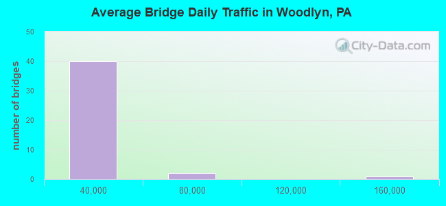
- 965,870Total average daily traffic
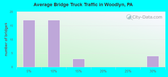
- 56,702Total average daily truck traffic
- National Bridge Inventory (NBI) Registered Bridges for Woodlyn
- No street view available for this location
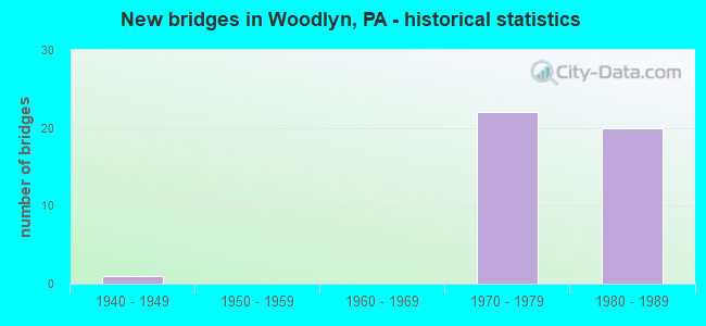
- New bridges - historical statistics
- 11940-1949
- 221970-1979
- 201980-1989
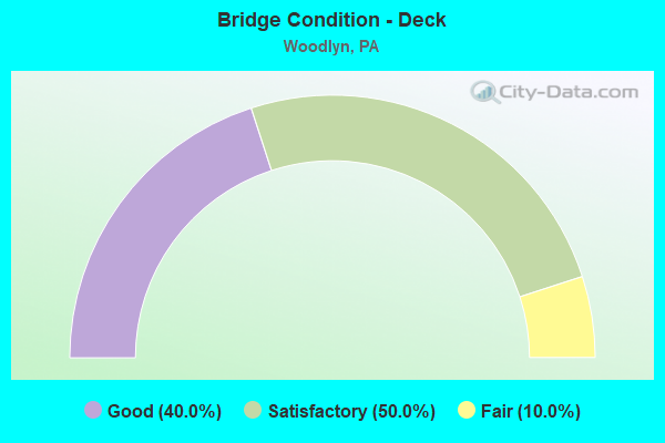
- Bridge Condition - Deck
- 40.0%Good
- 50.0%Satisfactory
- 10.0%Fair
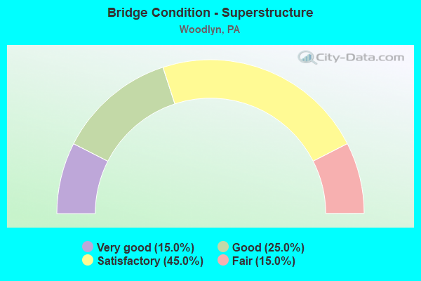
- Bridge Condition - Superstructure
- 15.0%Very good
- 25.0%Good
- 45.0%Satisfactory
- 15.0%Fair
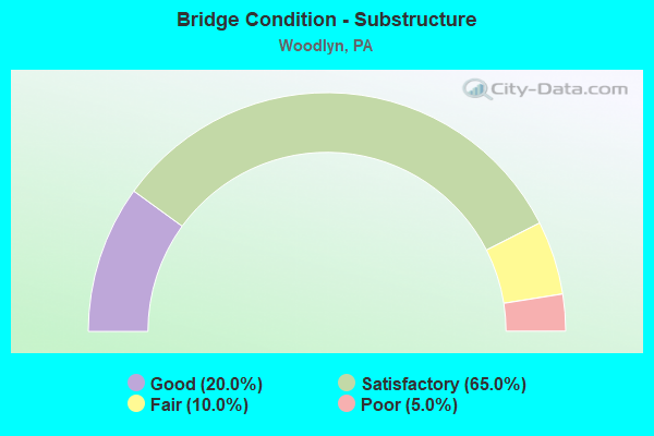
- Bridge Condition - Substructure
- 20.0%Good
- 65.0%Satisfactory
- 10.0%Fair
- 5.0%Poor
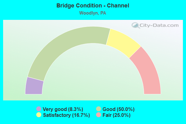
- Bridge Condition - Channel
- 8.3%Very good
- 50.0%Good
- 16.7%Satisfactory
- 25.0%Fair
Find on map >> Show street view
Structure Number: 14901, Location: 2MI.NORTH LR-132 43J02 (Lat: 39.864417, Lng: -75.348119), Route carried "on" structure: Interstate 95, Year Built: 1975, Status: Open, Structure Length: 2.74m (8.99ft), Average Daily Traffic: 157,679 (year 2022), Truck Traffic: 7%, Average Future Daily Traffic: 175,419 (year 2032), Design Load: HS 20, Features Intersected: BULLENS LANE (TURNBACK)
Minimum Vertical Clearance: 30+ m (98+ ft), Kilometerpoint: 9.619, Lanes on structure: 3, Lanes under structure: 4, Base Highway Network: Yes, Owner: State Highway Agency, Approaching Roadway Width: 32.0m (105.0ft), Skew: 31 degrees, Material/Design: Steel, Design/Construction: Stringer/Multi-beam, Number Of Spans In Main Unit: 1, Length of Maximum Span: 26.2m (86.0ft), Curb or Sidewalk Widths: Left: 0.2m (0.7ft), Right: 0.2m (0.7ft), Curb-To-Curb Width: 30.5m (100.1ft), Out-to-Out Width: 32.6m (107.0ft)
Condition: Deck: Satisfactory, Superstructure: Good, Substructure: Satisfactory, Operating Rating: 98.9 metric tons, Method Used To Determine Operating Rating: Load Factor (LF), Inventory Rating: 59.0 metric tons, Method Used To Determine Inventory Rating: Load Factor (LF), Structural Evaluation: Equal to present minimum criteria, Deck Geometry: Superior to present desirable criteria, Underclear: Somewhat better than minimum adequacy, Approach Roadway Alignment: Equal to present desirable criteria, Length Of Structure Improvement: 3.50m (11.48ft), Designated Inspection Frequency: Every 24 months, Inspection Date: May 2020, Deck Structure Type: Concrete Cast-file-Place, Wearing Surface/Protective System: Wearing Surface: Monolithic Concrete
Find on map >> Show street view
Structure Number: 14904, Location: JUNCTION W/I-476 43K01 (Lat: 39.867450, Lng: -75.343581), Route carried "on" structure: Interstate 95, Year Built: 1975, Status: Open, Structure Length: 5.24m (17.19ft), Average Daily Traffic: 35,037 (year 2022), Truck Traffic: 3%, Average Future Daily Traffic: 84,887 (year 2032), Design Load: HS 20, Features Intersected: RAMP M2 TO I95 (NB)
Minimum Vertical Clearance: 30+ m (98+ ft), Kilometerpoint: 10.614, Lanes on structure: 2, Lanes under structure: 2, Base Highway Network: Yes, Owner: State Highway Agency, Approaching Roadway Width: 13.1m (43.0ft), Skew: 13 degrees, Material/Design: Steel, Design/Construction: Stringer/Multi-beam, Number Of Spans In Main Unit: 1, Number Of Approach Spans: 2, Length of Maximum Span: 24.7m (81.0ft), Curb or Sidewalk Widths: Left: 0.2m (0.7ft), Right: 0.2m (0.7ft), Curb-To-Curb Width: 12.3m (40.4ft), Out-to-Out Width: 13.4m (44.0ft)
Condition: Deck: Satisfactory, Superstructure: Fair, Substructure: Satisfactory, Operating Rating: 61.7 metric tons, Method Used To Determine Operating Rating: Load Factor (LF), Inventory Rating: 37.2 metric tons, Method Used To Determine Inventory Rating: Load Factor (LF), Structural Evaluation: Somewhat better than minimum adequacy, Deck Geometry: Better than present minimum criteria, Underclear: Somewhat better than minimum adequacy, Approach Roadway Alignment: Equal to present desirable criteria, Length Of Structure Improvement: 6.30m (20.67ft), Designated Inspection Frequency: Every 24 months, Inspection Date: June 2020, Deck Structure Type: Concrete Cast-file-Place, Wearing Surface/Protective System: Wearing Surface: Latex Concrete
Find on map >> Show street view
Structure Number: 14905, Location: JUNCTION W/I-476 43K01 (Lat: 39.867956, Lng: -75.341975), Route carried "on" structure: Interstate 95, Year Built: 1975, Status: Open, Structure Length: 13.08m (42.91ft), Average Daily Traffic: 35,037 (year 2022), Truck Traffic: 3%, Average Future Daily Traffic: 84,887 (year 2032), Design Load: HS 20, Features Intersected: CRUM CREEK
Minimum Vertical Clearance: 30+ m (98+ ft), Kilometerpoint: 10.614, Lanes on structure: 2, Base Highway Network: Yes, Owner: State Highway Agency, Approaching Roadway Width: 13.1m (43.0ft), Skew: 13 degrees, Material/Design: Steel continuous, Design/Construction: Stringer/Multi-beam, Number Of Spans In Main Unit: 4, Number Of Approach Spans: 1, Length of Maximum Span: 37.5m (123.0ft), Curb or Sidewalk Widths: Left: 0.2m (0.7ft), Right: 0.2m (0.7ft), Curb-To-Curb Width: 12.0m (39.4ft), Out-to-Out Width: 13.2m (43.3ft)
Condition: Deck: Satisfactory, Superstructure: Satisfactory, Substructure: Satisfactory, Channel: Satisfactory, Operating Rating: 63.5 metric tons, Method Used To Determine Operating Rating: Load Factor (LF), Inventory Rating: 38.1 metric tons, Method Used To Determine Inventory Rating: Load Factor (LF), Structural Evaluation: Equal to present minimum criteria, Deck Geometry: Equal to present minimum criteria, Waterway Adequacy: Superior to present desirable criteria, Approach Roadway Alignment: Equal to present desirable criteria, Length Of Structure Improvement: 12.80m (41.99ft), Designated Inspection Frequency: Every 24 months, Inspection Date: May 2020, Deck Structure Type: Concrete Cast-file-Place, Wearing Surface/Protective System: Wearing Surface: Latex Concrete
Find on map >> Show street view
Structure Number: 14906, Location: CHESTER PIKE 43K01 (Lat: 39.867806, Lng: -75.338831), Route carried "on" structure: Interstate 95, Year Built: 1975, Status: Open, Structure Length: 5.24m (17.19ft), Average Daily Traffic: 35,037 (year 2022), Truck Traffic: 3%, Average Future Daily Traffic: 84,887 (year 2032), Design Load: HS 20, Features Intersected: CHESTER PIKE
Minimum Vertical Clearance: 30+ m (98+ ft), Kilometerpoint: 10.614, Lanes on structure: 4, Lanes under structure: 4, Base Highway Network: Yes, Owner: State Highway Agency, Approaching Roadway Width: 24.4m (80.1ft), Skew: 14 degrees, Material/Design: Steel, Design/Construction: Stringer/Multi-beam, Number Of Spans In Main Unit: 1, Number Of Approach Spans: 2, Length of Maximum Span: 28.7m (94.2ft), Curb-To-Curb Width: 20.7m (67.9ft), Out-to-Out Width: 22.6m (74.1ft)
Condition: Deck: Satisfactory, Superstructure: Satisfactory, Substructure: Satisfactory, Operating Rating: 57.2 metric tons, Method Used To Determine Operating Rating: Load Factor (LF), Inventory Rating: 34.5 metric tons, Method Used To Determine Inventory Rating: Load Factor (LF), Structural Evaluation: Equal to present minimum criteria, Deck Geometry: Equal to present minimum criteria, Underclear: Meets minimum limits, Approach Roadway Alignment: Equal to present desirable criteria, Length Of Structure Improvement: 6.20m (20.34ft), Designated Inspection Frequency: Every 24 months, Inspection Date: May 2020, Deck Structure Type: Concrete Cast-file-Place, Wearing Surface/Protective System: Wearing Surface: Latex Concrete
Find on map >> Show street view
Structure Number: 14907, Location: JUNCTION W/I-476 43K01 (Lat: 39.867542, Lng: -75.343789), Route carried "on" structure: Interstate 95, Year Built: 1975, Status: Open, Structure Length: 4.88m (16.01ft), Average Daily Traffic: 34,309 (year 2022), Truck Traffic: 4%, Average Future Daily Traffic: 61,991 (year 2032), Design Load: HS 20, Features Intersected: RAMP M2 TO I-95 NB
Minimum Vertical Clearance: 30+ m (98+ ft), Kilometerpoint: 10.644, Lanes on structure: 2, Lanes under structure: 1, Base Highway Network: Yes, Owner: State Highway Agency, Approaching Roadway Width: 13.1m (43.0ft), Skew: 10 degrees, Material/Design: Steel, Design/Construction: Stringer/Multi-beam, Number Of Spans In Main Unit: 1, Number Of Approach Spans: 2, Length of Maximum Span: 22.6m (74.1ft), Curb or Sidewalk Widths: Left: 0.2m (0.7ft), Right: 0.2m (0.7ft), Curb-To-Curb Width: 12.3m (40.4ft), Out-to-Out Width: 13.4m (44.0ft)
Condition: Deck: Satisfactory, Superstructure: Fair, Substructure: Satisfactory, Operating Rating: 65.3 metric tons, Method Used To Determine Operating Rating: Load Factor (LF), Inventory Rating: 39.0 metric tons, Method Used To Determine Inventory Rating: Load Factor (LF), Structural Evaluation: Somewhat better than minimum adequacy, Deck Geometry: Better than present minimum criteria, Underclear: Superior to present desirable criteria, Approach Roadway Alignment: Equal to present desirable criteria, Length Of Structure Improvement: 5.80m (19.03ft), Designated Inspection Frequency: Every 24 months, Inspection Date: June 2020, Deck Structure Type: Concrete Cast-file-Place, Wearing Surface/Protective System: Wearing Surface: Monolithic Concrete
Find on map >> Show street view
Structure Number: 14908, Location: JUNCTION W/I-476 43K01 (Lat: 39.868094, Lng: -75.342264), Route carried "on" structure: Interstate 95, Year Built: 1975, Status: Open, Structure Length: 12.01m (39.40ft), Average Daily Traffic: 34,309 (year 2022), Truck Traffic: 4%, Average Future Daily Traffic: 61,991 (year 2032), Design Load: HS 20, Features Intersected: CRUM CREEK
Minimum Vertical Clearance: 30+ m (98+ ft), Kilometerpoint: 10.644, Lanes on structure: 2, Base Highway Network: Yes, Owner: State Highway Agency, Approaching Roadway Width: 13.1m (43.0ft), Skew: 13 degrees, Material/Design: Steel continuous, Design/Construction: Stringer/Multi-beam, Number Of Spans In Main Unit: 3, Number Of Approach Spans: 2, Length of Maximum Span: 34.7m (113.8ft), Curb or Sidewalk Widths: Left: 0.2m (0.7ft), Right: 0.2m (0.7ft), Curb-To-Curb Width: 12.0m (39.4ft), Out-to-Out Width: 13.2m (43.3ft)
Condition: Deck: Satisfactory, Superstructure: Satisfactory, Substructure: Satisfactory, Channel: Satisfactory, Operating Rating: 63.5 metric tons, Method Used To Determine Operating Rating: Load Factor (LF), Inventory Rating: 38.1 metric tons, Method Used To Determine Inventory Rating: Load Factor (LF), Structural Evaluation: Equal to present minimum criteria, Deck Geometry: Equal to present minimum criteria, Waterway Adequacy: Superior to present desirable criteria, Approach Roadway Alignment: Equal to present desirable criteria, Length Of Structure Improvement: 12.80m (41.99ft), Designated Inspection Frequency: Every 24 months, Inspection Date: May 2020, Deck Structure Type: Concrete Cast-file-Place, Wearing Surface/Protective System: Wearing Surface: Latex Concrete
Find on map >> Show street view
Structure Number: 14912, Location: .5MI.S.STEWART AVE.44A01 (Lat: 39.867408, Lng: -75.333569), Route carried "on" structure: Interstate 95, Year Built: 1975, Status: Open, Structure Length: 8.23m (27.00ft), Average Daily Traffic: 35,037 (year 2022), Truck Traffic: 3%, Average Future Daily Traffic: 84,887 (year 2032), Design Load: HS 20, Features Intersected: AMTRAK
Minimum Vertical Clearance: 30+ m (98+ ft), Kilometerpoint: 11.219, Lanes on structure: 4, Base Highway Network: Yes, Owner: State Highway Agency, Approaching Roadway Width: 24.4m (80.1ft), Skew: 14 degrees, Material/Design: Steel, Design/Construction: Stringer/Multi-beam, Number Of Spans In Main Unit: 1, Number Of Approach Spans: 2, Length of Maximum Span: 41.1m (134.8ft), Curb-To-Curb Width: 21.9m (71.9ft), Out-to-Out Width: 21.9m (71.9ft)
Condition: Deck: Satisfactory, Superstructure: Satisfactory, Substructure: Satisfactory, Operating Rating: 86.2 metric tons, Method Used To Determine Operating Rating: Load Factor (LF), Inventory Rating: 51.7 metric tons, Method Used To Determine Inventory Rating: Load Factor (LF), Structural Evaluation: Equal to present minimum criteria, Deck Geometry: Better than present minimum criteria, Underclear: High priority of corrective action, Approach Roadway Alignment: Equal to present desirable criteria, Length Of Structure Improvement: 9.60m (31.50ft), Designated Inspection Frequency: Every 24 months, Inspection Date: September 2020, Deck Structure Type: Concrete Cast-file-Place, Wearing Surface/Protective System: Wearing Surface: Latex Concrete
Find on map >> Show street view
Structure Number: 15024, Location: MACDADE BLVD.INTR. 34J13 (Lat: 39.873333, Lng: -75.343333), Route carried "on" structure: Interstate 476, Year Built: 1987, Status: Open, Structure Length: 7.22m (23.69ft), Average Daily Traffic: 42,653 (year 2022), Truck Traffic: 9%, Average Future Daily Traffic: 57,931 (year 2032), Design Load: HS 20+Mod, Features Intersected: MACDADE BLVD & CRUM CR., Facility Carried by Structure: MID-COUNTY EXWY.SB
Minimum Vertical Clearance: 30+ m (98+ ft), Kilometerpoint: 0.000, Lanes on structure: 3, Lanes under structure: 4, Base Highway Network: Yes, Owner: State Highway Agency, Approaching Roadway Width: 28.0m (91.9ft), Skew: 32 degrees, Material/Design: Steel, Design/Construction: Stringer/Multi-beam, Number Of Spans In Main Unit: 2, Length of Maximum Span: 36.0m (118.1ft), Curb or Sidewalk Widths: Left: 0.2m (0.7ft), Right: 0.2m (0.7ft), Curb-To-Curb Width: 25.7m (84.3ft), Out-to-Out Width: 27.2m (89.2ft)
Condition: Deck: Good, Superstructure: Good, Substructure: Satisfactory, Channel: Good, Inventory Rating: 59.9 metric tons, Method Used To Determine Inventory Rating: Load Factor (LF), Structural Evaluation: Equal to present minimum criteria, Deck Geometry: Superior to present desirable criteria, Underclear: Superior to present desirable criteria, Waterway Adequacy: Superior to present desirable criteria, Approach Roadway Alignment: Better than present minimum criteria, Length Of Structure Improvement: 8.20m (26.90ft), Designated Inspection Frequency: Every 24 months, Inspection Date: November 2019, Deck Structure Type: Concrete Cast-file-Place, Wearing Surface/Protective System: Wearing Surface: Latex Concrete, Deck Protection: Epoxy Coated Reinforcing
Find on map >> Show street view
Structure Number: 15226, Location: JUST EAST I-476 34J13 (Lat: 39.874125, Lng: -75.350083), Route carried "on" structure: Alternate State highway , Year Built: 1987, Status: Open, Structure Length: 2.90m (9.51ft), Average Daily Traffic: 26,122 (year 2022), Truck Traffic: 5%, Average Future Daily Traffic: 29,853 (year 2032), Design Load: HS 20+Mod, Features Intersected: CRUM CREEK, Facility Carried by Structure: MACDADE BOULEVARD
Minimum Vertical Clearance: 30+ m (98+ ft), Kilometerpoint: 3.121, Lanes on structure: 5, Base Highway Network: Yes, Owner: State Highway Agency, Approaching Roadway Width: 22.9m (75.1ft), Skew: 24 degrees, Material/Design: Concrete, Design/Construction: Culvert, Number Of Spans In Main Unit: 3, Length of Maximum Span: 9.4m (30.8ft), Curb or Sidewalk Widths: Left: 0.2m (0.7ft), Right: 0.2m (0.7ft), Curb-To-Curb Width: 22.5m (73.8ft), Out-to-Out Width: 28.0m (91.9ft)
Condition: Channel: Fair, Culverts: Satisfactory, Operating Rating: 64.4 metric tons, Method Used To Determine Operating Rating: Load Factor (LF), Inventory Rating: 38.1 metric tons, Method Used To Determine Inventory Rating: Load Factor (LF), Structural Evaluation: Equal to present minimum criteria, Deck Geometry: Equal to present minimum criteria, Waterway Adequacy: Superior to present desirable criteria, Approach Roadway Alignment: Equal to present desirable criteria, Length Of Structure Improvement: 3.80m (12.47ft), Designated Inspection Frequency: Every 24 months, Inspection Date: July 2021, Deck Structure Type: Concrete Cast-file-Place, Wearing Surface/Protective System: Wearing Surface: Monolithic Concrete, Deck Protection: Epoxy Coated Reinforcing
Find on map >> Show street view
Structure Number: 15235, Location: MACDADE BLVD.INTR. 34J12 (Lat: 39.873333, Lng: -75.350000), Route carried "on" structure: State highway , Year Built: 1987, Status: Open, Structure Length: 5.94m (19.49ft), Average Daily Traffic: 1,721 (year 2022), Truck Traffic: 3%, Average Future Daily Traffic: 9,666 (year 2032), Design Load: HS 25 or greater, Features Intersected: MID-CTY;RAMP 6, Facility Carried by Structure: BULLENS LANE
Minimum Vertical Clearance: 30+ m (98+ ft), Kilometerpoint: 0.000, Lanes on structure: 2, Lanes under structure: 5, Owner: State Highway Agency, Approaching Roadway Width: 10.4m (34.1ft), Skew: 1 degrees, Material/Design: Steel continuous, Design/Construction: Stringer/Multi-beam, Number Of Spans In Main Unit: 2, Length of Maximum Span: 32.3m (106.0ft), Curb or Sidewalk Widths: Left: 0.2m (0.7ft), Right: 1.8m (5.9ft), Curb-To-Curb Width: 10.4m (34.1ft), Out-to-Out Width: 13.0m (42.7ft)
Condition: Deck: Good, Superstructure: Very good, Substructure: Satisfactory, Operating Rating: 75.3 metric tons, Method Used To Determine Operating Rating: Load Factor (LF), Inventory Rating: 45.4 metric tons, Method Used To Determine Inventory Rating: Load Factor (LF), Structural Evaluation: Equal to present minimum criteria, Deck Geometry: Equal to present minimum criteria, Underclear: Superior to present desirable criteria, Approach Roadway Alignment: Better than present minimum criteria, Length Of Structure Improvement: 6.90m (22.64ft), Designated Inspection Frequency: Every 24 months, Inspection Date: January 2020, Deck Structure Type: Concrete Cast-file-Place, Wearing Surface/Protective System: Wearing Surface: Monolithic Concrete, Deck Protection: Epoxy Coated Reinforcing
Find on map >> Show street view
Structure Number: 15461, Location: 0.4 Mi NW US-13 ADC 28-A5 (Lat: 39.875700, Lng: -75.336697), Route carried "on" structure: City street , Year Built: 1947, Status: Open, Structure Length: 3.81m (12.50ft), Average Daily Traffic: 1,437 (year 2016), Truck Traffic: 5%, Average Future Daily Traffic: 1,437 (year 2019), Features Intersected: CSX TRANSPORTATION, Facility Carried by Structure: CRUM LYNNE ROAD
Minimum Vertical Clearance: 30+ m (98+ ft), Kilometerpoint: 0.000, Lanes on structure: 2, Owner: Railroad, Approaching Roadway Width: 7.3m (24.0ft), Material/Design: Wood or Timber, Design/Construction: Stringer/Multi-beam, Number Of Spans In Main Unit: 5, Length of Maximum Span: 11.0m (36.1ft), Curb or Sidewalk Widths: Left: 1.3m (4.3ft), Right: 1.3m (4.3ft), Curb-To-Curb Width: 7.3m (24.0ft), Out-to-Out Width: 7.7m (25.3ft)
Condition: Deck: Fair, Superstructure: Satisfactory, Substructure: Poor, Operating Rating: 45.4 metric tons, Method Used To Determine Operating Rating: Allowable Stress (AS), Inventory Rating: 31.8 metric tons, Method Used To Determine Inventory Rating: Allowable Stress (AS), Structural Evaluation: Meets minimum limits, Deck Geometry: Meets minimum limits, Underclear: High priority of corrective action, Approach Roadway Alignment: Somewhat better than minimum adequacy, Length Of Structure Improvement: 3.80m (12.47ft), Designated Inspection Frequency: Every 24 months, Inspection Date: March 2021, Bridge Improvement Cost: $15,000, Roadway Improvement Cost: $44,000, Total Project Cost: $203,000, Deck Structure Type: Wood or Timber, Wearing Surface/Protective System: Wearing Surface: Bituminous
Find on map >> Show street view
Structure Number: 15479, Location: JUNCTION I-476 43K01 (Lat: 39.873889, Lng: -75.350000), Route carried "on" structure: Ramp State highway , Year Built: 1975, Status: Open, Structure Length: 29.29m (96.10ft), Average Daily Traffic: 22,848 (year 2021), Truck Traffic: 11%, Average Future Daily Traffic: 31,972 (year 2032), Design Load: HS 20, Features Intersected: I-95,CSX RR;&CRUM CREEK, Facility Carried by Structure: RAMP M3(NB)I-476
Minimum Vertical Clearance: 30+ m (98+ ft), Kilometerpoint: 0.000, Lanes on structure: 1, Lanes under structure: 6, Base Highway Network: Yes, Owner: State Highway Agency, Approaching Roadway Width: 12.8m (42.0ft), Skew: 3 degrees, Material/Design: Steel continuous, Design/Construction: Stringer/Multi-beam, Number Of Spans In Main Unit: 6, Number Of Approach Spans: 3, Length of Maximum Span: 35.1m (115.2ft), Curb-To-Curb Width: 12.9m (42.3ft), Out-to-Out Width: 14.0m (45.9ft)
Condition: Deck: Satisfactory, Superstructure: Satisfactory, Substructure: Satisfactory, Channel: Very good, Operating Rating: 59.9 metric tons, Method Used To Determine Operating Rating: Load Factor (LF), Inventory Rating: 35.4 metric tons, Method Used To Determine Inventory Rating: Load Factor (LF), Structural Evaluation: Equal to present minimum criteria, Deck Geometry: Superior to present desirable criteria, Underclear: Equal to present minimum criteria, Waterway Adequacy: Superior to present desirable criteria, Approach Roadway Alignment: Equal to present minimum criteria, Length Of Structure Improvement: 29.20m (95.80ft), Designated Inspection Frequency: Every 24 months, Inspection Date: October 2020, Deck Structure Type: Concrete Cast-file-Place, Wearing Surface/Protective System: Wearing Surface: Latex Concrete
Find on map >> Show street view
Structure Number: 15481, Location: SO.MC DAVID BLVD. 43J01 (Lat: 39.871258, Lng: -75.346906), Route carried "on" structure: State highway , Year Built: 1987, Status: Open, Structure Length: 3.69m (12.11ft), Average Daily Traffic: 22,848 (year 2021), Truck Traffic: 11%, Average Future Daily Traffic: 31,972 (year 2032), Design Load: HS 20+Mod, Features Intersected: RAMP 2 N.B.TO MACDADE, Facility Carried by Structure: MID-COUNTY EXWY.NB
Minimum Vertical Clearance: 30+ m (98+ ft), Kilometerpoint: 0.000, Lanes on structure: 2, Lanes under structure: 1, Base Highway Network: Yes, Owner: State Highway Agency, Approaching Roadway Width: 12.5m (41.0ft), Skew: 6 degrees, Material/Design: Steel, Design/Construction: Stringer/Multi-beam, Number Of Spans In Main Unit: 1, Length of Maximum Span: 33.8m (110.9ft), Curb or Sidewalk Widths: Left: 0.2m (0.7ft), Right: 0.2m (0.7ft), Curb-To-Curb Width: 12.1m (39.7ft), Out-to-Out Width: 13.2m (43.3ft)
Condition: Deck: Good, Superstructure: Good, Substructure: Good, Operating Rating: 90.7 metric tons, Method Used To Determine Operating Rating: Load Factor (LF), Inventory Rating: 54.4 metric tons, Method Used To Determine Inventory Rating: Load Factor (LF), Structural Evaluation: Better than present minimum criteria, Deck Geometry: Equal to present minimum criteria, Underclear: High priority of corrective action, Approach Roadway Alignment: Equal to present desirable criteria, Length Of Structure Improvement: 4.80m (15.75ft), Designated Inspection Frequency: Every 24 months, Inspection Date: May 2020, Deck Structure Type: Concrete Cast-file-Place, Wearing Surface/Protective System: Wearing Surface: Monolithic Concrete, Deck Protection: Epoxy Coated Reinforcing
Find on map >> Show street view
Structure Number: 15482, Location: AT 795 INTERCHANGE 43J01 (Lat: 39.867272, Lng: -75.345439), Route carried "on" structure: Ramp State highway , Year Built: 1975, Status: Open, Structure Length: 2.35m (7.71ft), Average Daily Traffic: 26,560 (year 2021), Truck Traffic: 7%, Average Future Daily Traffic: 25,597 (year 2032), Design Load: HS 20, Features Intersected: RELOC.CRUM CREEK, Facility Carried by Structure: RAMP M1 TO 95 SB
Minimum Vertical Clearance: 30+ m (98+ ft), Kilometerpoint: 0.000, Lanes on structure: 3, Base Highway Network: Yes, Owner: State Highway Agency, Approaching Roadway Width: 15.8m (51.8ft), Skew: 3 degrees, Material/Design: Prestressed concrete, Design/Construction: Box Beam or Girders - Single/Spread, Number Of Spans In Main Unit: 1, Length of Maximum Span: 23.2m (76.1ft), Curb or Sidewalk Widths: Left: 0.2m (0.7ft), Right: 0.2m (0.7ft), Curb-To-Curb Width: 15.5m (50.9ft), Out-to-Out Width: 16.4m (53.8ft)
Condition: Deck: Good, Superstructure: Satisfactory, Substructure: Satisfactory, Channel: Good, Operating Rating: 68.0 metric tons, Method Used To Determine Operating Rating: Load Factor (LF), Inventory Rating: 29.0 metric tons, Method Used To Determine Inventory Rating: Load Factor (LF), Structural Evaluation: Equal to present minimum criteria, Deck Geometry: Superior to present desirable criteria, Waterway Adequacy: Superior to present desirable criteria, Approach Roadway Alignment: Equal to present desirable criteria, Length Of Structure Improvement: 3.20m (10.50ft), Designated Inspection Frequency: Every 24 months, Inspection Date: March 2020, Deck Structure Type: Concrete Cast-file-Place, Wearing Surface/Protective System: Wearing Surface: Latex Concrete
Find on map >> Show street view
Structure Number: 15485, Location: JUNCTION W/I-476 43K01 (Lat: 39.867756, Lng: -75.340747), Route carried "on" structure: Ramp State highway , Year Built: 1975, Year Reconstructed: 1988, Status: Open, Structure Length: 12.31m (40.39ft), Average Daily Traffic: 25,906 (year 2021), Truck Traffic: 4%, Average Future Daily Traffic: 23,412 (year 2032), Design Load: HS 20, Features Intersected: PADOT STOCK PILE;CRUM CK, Facility Carried by Structure: RAMP M2;NB ON
Minimum Vertical Clearance: 30+ m (98+ ft), Kilometerpoint: 0.000, Lanes on structure: 2, Base Highway Network: Yes, Owner: State Highway Agency, Approaching Roadway Width: 11.6m (38.1ft), Skew: 3 degrees, Material/Design: Steel continuous, Design/Construction: Stringer/Multi-beam, Number Of Spans In Main Unit: 4, Number Of Approach Spans: 2, Length of Maximum Span: 33.5m (109.9ft), Curb or Sidewalk Widths: Left: 0.2m (0.7ft), Right: 0.2m (0.7ft), Curb-To-Curb Width: 12.0m (39.4ft), Out-to-Out Width: 13.2m (43.3ft)
Condition: Deck: Satisfactory, Superstructure: Satisfactory, Substructure: Satisfactory, Channel: Good, Operating Rating: 51.7 metric tons, Method Used To Determine Operating Rating: Load Factor (LF), Inventory Rating: 30.8 metric tons, Method Used To Determine Inventory Rating: Load Factor (LF), Structural Evaluation: Equal to present minimum criteria, Deck Geometry: Superior to present desirable criteria, Waterway Adequacy: Superior to present desirable criteria, Approach Roadway Alignment: Better than present minimum criteria, Length Of Structure Improvement: 13.20m (43.31ft), Designated Inspection Frequency: Every 24 months, Inspection Date: May 2020, Deck Structure Type: Concrete Cast-file-Place, Wearing Surface/Protective System: Wearing Surface: Latex Concrete
Find on map >> Show street view
Structure Number: 15486, Location: MC DADE BLVD.INTC. 43J01 (Lat: 39.871667, Lng: -75.350000), Route carried "on" structure: State highway , Year Built: 1987, Status: Open, Structure Length: 3.66m (12.01ft), Average Daily Traffic: 26,560 (year 2021), Truck Traffic: 7%, Average Future Daily Traffic: 25,597 (year 2032), Design Load: HS 20+Mod, Features Intersected: RAMP 3 TO I-95 (NB), Facility Carried by Structure: MID-COUNTY EXWY.SB
Minimum Vertical Clearance: 30+ m (98+ ft), Kilometerpoint: 0.000, Lanes on structure: 2, Lanes under structure: 1, Base Highway Network: Yes, Owner: State Highway Agency, Approaching Roadway Width: 11.6m (38.1ft), Skew: 6 degrees, Material/Design: Steel, Design/Construction: Stringer/Multi-beam, Number Of Spans In Main Unit: 1, Length of Maximum Span: 35.1m (115.2ft), Curb or Sidewalk Widths: Left: 0.2m (0.7ft), Right: 0.2m (0.7ft), Curb-To-Curb Width: 12.0m (39.4ft), Out-to-Out Width: 13.2m (43.3ft)
Condition: Deck: Good, Superstructure: Very good, Substructure: Fair, Inventory Rating: 69.9 metric tons, Method Used To Determine Inventory Rating: Load Factor (LF), Structural Evaluation: Somewhat better than minimum adequacy, Deck Geometry: Equal to present minimum criteria, Underclear: High priority of corrective action, Approach Roadway Alignment: Equal to present desirable criteria, Length Of Structure Improvement: 4.70m (15.42ft), Designated Inspection Frequency: Every 24 months, Inspection Date: June 2020, Deck Structure Type: Concrete Cast-file-Place, Wearing Surface/Protective System: Wearing Surface: Monolithic Concrete, Deck Protection: Epoxy Coated Reinforcing
Find on map >> Show street view
Structure Number: 15487, Location: AT 795 INTERCHANGE 43J01 (Lat: 39.871094, Lng: -75.347603), Route carried "on" structure: Ramp State highway , Year Built: 1975, Status: Open, Structure Length: 2.29m (7.51ft), Average Daily Traffic: 25,906 (year 2021), Truck Traffic: 4%, Average Future Daily Traffic: 23,412 (year 2032), Design Load: HS 20, Features Intersected: RELOC. CRUM CREEK, Facility Carried by Structure: RAMP M2 TO I-95 NB
Minimum Vertical Clearance: 30+ m (98+ ft), Kilometerpoint: 0.000, Lanes on structure: 2, Base Highway Network: Yes, Owner: State Highway Agency, Approaching Roadway Width: 14.9m (48.9ft), Skew: 2 degrees, Material/Design: Prestressed concrete, Design/Construction: Box Beam or Girders - Single/Spread, Number Of Spans In Main Unit: 1, Length of Maximum Span: 22.6m (74.1ft), Curb or Sidewalk Widths: Left: 0.2m (0.7ft), Right: 0.2m (0.7ft), Curb-To-Curb Width: 14.8m (48.6ft), Out-to-Out Width: 16.0m (52.5ft)
Condition: Deck: Satisfactory, Superstructure: Satisfactory, Substructure: Fair, Channel: Fair, Operating Rating: 66.2 metric tons, Method Used To Determine Operating Rating: Load Factor (LF), Inventory Rating: 29.9 metric tons, Method Used To Determine Inventory Rating: Load Factor (LF), Structural Evaluation: Somewhat better than minimum adequacy, Deck Geometry: Superior to present desirable criteria, Waterway Adequacy: Equal to present minimum criteria, Approach Roadway Alignment: Equal to present desirable criteria, Length Of Structure Improvement: 3.10m (10.17ft), Designated Inspection Frequency: Every 24 months, Inspection Date: November 2020, Deck Structure Type: Concrete Cast-file-Place, Wearing Surface/Protective System: Wearing Surface: Latex Concrete
Find on map >> Show street view
Structure Number: 15488, Location: MACDADE BLVD.INTCH.43J01 (Lat: 39.872842, Lng: -75.351189), Route carried "on" structure: Ramp State highway , Year Built: 1987, Status: Open, Structure Length: 5.27m (17.29ft), Average Daily Traffic: 2,623 (year 2021), Truck Traffic: 4%, Average Future Daily Traffic: 4,965 (year 2032), Design Load: HS 20+Mod, Features Intersected: RELOCATED CRUM CREEK, Facility Carried by Structure: RAMP 1A (SB)
Minimum Vertical Clearance: 30+ m (98+ ft), Kilometerpoint: 0.000, Lanes on structure: 1, Base Highway Network: Yes, Owner: State Highway Agency, Approaching Roadway Width: 9.8m (32.2ft), Skew: 9 degrees, Material/Design: Steel continuous, Design/Construction: Girder and Floorbeam System, Number Of Spans In Main Unit: 3, Length of Maximum Span: 20.4m (66.9ft), Curb or Sidewalk Widths: Left: 0.2m (0.7ft), Right: 0.2m (0.7ft), Curb-To-Curb Width: 9.6m (31.5ft), Out-to-Out Width: 10.8m (35.4ft)
Condition: Deck: Good, Superstructure: Good, Substructure: Good, Channel: Good, Operating Rating: 58.1 metric tons, Method Used To Determine Operating Rating: Load Factor (LF), Inventory Rating: 34.5 metric tons, Method Used To Determine Inventory Rating: Load Factor (LF), Structural Evaluation: Better than present minimum criteria, Deck Geometry: Superior to present desirable criteria, Waterway Adequacy: Superior to present desirable criteria, Approach Roadway Alignment: Equal to present minimum criteria, Length Of Structure Improvement: 6.30m (20.67ft), Designated Inspection Frequency: Every 24 months, Critical Feature Inspection Frequency: Every 24 months, Inspection Date: August 2020, Critical Feature Inspection Date: August 2020, Deck Structure Type: Concrete Cast-file-Place, Wearing Surface/Protective System: Wearing Surface: Monolithic Concrete, Deck Protection: Epoxy Coated Reinforcing
Find on map >> Show street view
Structure Number: 15496, Location: MACDAE BLVD.INTCH. 34J13 (Lat: 39.875000, Lng: -75.350000), Route carried "on" structure: Ramp State highway , Year Built: 1987, Status: Open, Structure Length: 6.95m (22.80ft), Average Daily Traffic: 3,152 (year 2022), Truck Traffic: 25%, Average Future Daily Traffic: 3,557 (year 2032), Design Load: HS 20+Mod, Features Intersected: CRUM CREEK;ACCESS ROAD, Facility Carried by Structure: RAMP M3 (WB)
Minimum Vertical Clearance: 30+ m (98+ ft), Kilometerpoint: 0.000, Lanes on structure: 1, Lanes under structure: 1, Base Highway Network: Yes, Owner: State Highway Agency, Approaching Roadway Width: 9.8m (32.2ft), Skew: 9 degrees, Material/Design: Steel continuous, Design/Construction: Girder and Floorbeam System, Number Of Spans In Main Unit: 3, Length of Maximum Span: 25.6m (84.0ft), Curb or Sidewalk Widths: Left: 0.2m (0.7ft), Right: 0.2m (0.7ft), Curb-To-Curb Width: 9.4m (30.8ft), Out-to-Out Width: 10.8m (35.4ft)
Condition: Deck: Good, Superstructure: Good, Substructure: Good, Channel: Fair, Operating Rating: 68.0 metric tons, Method Used To Determine Operating Rating: Load Factor (LF), Inventory Rating: 40.8 metric tons, Method Used To Determine Inventory Rating: Load Factor (LF), Structural Evaluation: Better than present minimum criteria, Deck Geometry: Superior to present desirable criteria, Underclear: High priority of corrective action, Waterway Adequacy: Superior to present desirable criteria, Approach Roadway Alignment: Better than present minimum criteria, Length Of Structure Improvement: 7.90m (25.92ft), Designated Inspection Frequency: Every 24 months, Critical Feature Inspection Frequency: Every 24 months, Inspection Date: November 2019, Critical Feature Inspection Date: November 2019, Deck Structure Type: Concrete Cast-file-Place, Wearing Surface/Protective System: Wearing Surface: Monolithic Concrete, Deck Protection: Epoxy Coated Reinforcing
Find on map >> Show street view
Structure Number: 15497, Location: MACDADE BLVD.INTER.34J13 (Lat: 39.876892, Lng: -75.350750), Route carried "on" structure: Ramp State highway , Year Built: 1987, Status: Open, Structure Length: 6.40m (21.00ft), Average Daily Traffic: 2,043 (year 2021), Truck Traffic: 25%, Average Future Daily Traffic: 2,863 (year 2032), Design Load: HS 20+Mod, Features Intersected: CRUM CREEK;ACCESS ROAD, Facility Carried by Structure: RAMP 6 NORTHBOUND
Minimum Vertical Clearance: 30+ m (98+ ft), Kilometerpoint: 0.000, Lanes on structure: 1, Lanes under structure: 1, Base Highway Network: Yes, Owner: State Highway Agency, Approaching Roadway Width: 9.1m (29.9ft), Skew: 2 degrees, Material/Design: Prestressed concrete, Design/Construction: Stringer/Multi-beam, Number Of Spans In Main Unit: 3, Length of Maximum Span: 21.0m (68.9ft), Curb or Sidewalk Widths: Left: 0.2m (0.7ft), Right: 0.2m (0.7ft), Curb-To-Curb Width: 9.2m (30.2ft), Out-to-Out Width: 10.5m (34.4ft)
Condition: Deck: Good, Superstructure: Very good, Substructure: Good, Channel: Good, Operating Rating: 82.6 metric tons, Method Used To Determine Operating Rating: Load Factor (LF), Inventory Rating: 45.4 metric tons, Method Used To Determine Inventory Rating: Load Factor (LF), Structural Evaluation: Better than present minimum criteria, Deck Geometry: Superior to present desirable criteria, Underclear: Superior to present desirable criteria, Waterway Adequacy: Superior to present desirable criteria, Approach Roadway Alignment: Equal to present desirable criteria, Length Of Structure Improvement: 7.40m (24.28ft), Designated Inspection Frequency: Every 24 months, Inspection Date: June 2020, Deck Structure Type: Concrete Cast-file-Place, Wearing Surface/Protective System: Wearing Surface: Monolithic Concrete, Deck Protection: Epoxy Coated Reinforcing
Find on map >> Show street view
Structure Number: 155, Location: MACDADE BLVD.INTER.43J01 (Lat: 39.868333, Lng: -75.341667), Route carried "on" structure: Ramp State highway , Year Built: 1987, Status: Open, Structure Length: 2.53m (8.30ft), Average Daily Traffic: 1,998 (year 2022), Truck Traffic: 5%, Average Future Daily Traffic: 3,446 (year 2032), Design Load: HS 15, Features Intersected: RELOCATED CRUM CREEK, Facility Carried by Structure: ACCESS RD "A" (EB)
Minimum Vertical Clearance: 30+ m (98+ ft), Kilometerpoint: 0.000, Lanes on structure: 2, Owner: State Highway Agency, Approaching Roadway Width: 5.5m (18.0ft), Material/Design: Prestressed concrete, Design/Construction: Box Beam or Girders - Multiple, Number Of Spans In Main Unit: 1, Length of Maximum Span: 25.3m (83.0ft), Curb-To-Curb Width: 5.5m (18.0ft), Out-to-Out Width: 6.6m (21.7ft)
Condition: Deck: Fair, Superstructure: Fair, Substructure: Satisfactory, Channel: Good, Operating Rating: 45.4 metric tons, Method Used To Determine Operating Rating: Load Factor (LF), Inventory Rating: 15.4 metric tons, Method Used To Determine Inventory Rating: Load Factor (LF), Structural Evaluation: Meets minimum limits, Deck Geometry: High priority of replacement, Waterway Adequacy: Better than present minimum criteria, Approach Roadway Alignment: Equal to present desirable criteria, Length Of Structure Improvement: 3.40m (11.15ft), Designated Inspection Frequency: Every 24 months, Inspection Date: May 2020, Deck Structure Type: Other, Wearing Surface/Protective System: Wearing Surface: Bituminous
Find on map >> Show street view
Structure Number: 14901, Location: 2MI.NORTH LR-132 43J02 (Lat: 39.864417, Lng: -75.348119), Route carried "under" structure: County highway , Year Built: 1975, Structure Length: 0. m, Average Daily Traffic: 14,830 (year 2000), Truck Traffic: 5%, Features Intersected: BULLENS LANE (TURNBACK), Facility Carried by Structure: INTERSTATE 95
Minimum Vertical Clearance: 4.50m (14.76ft), Kilometerpoint: 0.000, Lanes on structure: 3, Lanes under structure: 4, Material/Design: Steel, Design/Construction: Stringer/Multi-beam, Length of Maximum Span: 26.2m (86.0ft)
Find on map >> Show street view
Structure Number: 14904, Location: JUNCTION W/I-476 43K01 (Lat: 39.867450, Lng: -75.343581), Route carried "under" structure: Ramp State highway , Year Built: 1975, Structure Length: 0. m, Average Daily Traffic: 25,906 (year 2021), Truck Traffic: 4%, Features Intersected: RAMP M2 TO I95 (NB), Facility Carried by Structure: INTERSTATE 95(NB)
Minimum Vertical Clearance: 5.03m (16.50ft), Kilometerpoint: 0.000, Lanes on structure: 2, Lanes under structure: 2, Material/Design: Steel, Design/Construction: Stringer/Multi-beam, Length of Maximum Span: 24.7m (81.0ft)
Find on map >> Show street view
Structure Number: 14906, Location: CHESTER PIKE 43K01 (Lat: 39.867806, Lng: -75.338831), Route carried "under" structure: US 13, Year Built: 1975, Structure Length: 0. m, Average Daily Traffic: 10,234 (year 2022), Truck Traffic: 5%, Features Intersected: CHESTER PIKE, Facility Carried by Structure: INTERSTATE 95(NB)
Minimum Vertical Clearance: 4.37m (14.34ft), Kilometerpoint: 10.813, Lanes on structure: 4, Lanes under structure: 2, Material/Design: Steel, Design/Construction: Stringer/Multi-beam, Length of Maximum Span: 28.7m (94.2ft)
Find on map >> Show street view
Structure Number: 14906, Location: CHESTER PIKE 43K01 (Lat: 39.867806, Lng: -75.338831), Route carried "under" structure: US 13, Year Built: 1975, Structure Length: 0. m, Average Daily Traffic: 10,781 (year 2022), Truck Traffic: 3%, Features Intersected: CHESTER PIKE, Facility Carried by Structure: INTERSTATE 95(NB)
Minimum Vertical Clearance: 4.37m (14.34ft), Kilometerpoint: 10.815, Lanes on structure: 4, Lanes under structure: 2, Material/Design: Steel, Design/Construction: Stringer/Multi-beam, Length of Maximum Span: 28.7m (94.2ft)
Find on map >> Show street view
Structure Number: 14907, Location: JUNCTION W/I-476 43K01 (Lat: 39.867542, Lng: -75.343789), Route carried "under" structure: Ramp State highway , Year Built: 1975, Structure Length: 0. m, Average Daily Traffic: 25,906 (year 2021), Truck Traffic: 4%, Features Intersected: RAMP M2 TO I-95 NB, Facility Carried by Structure: INTERSTATE 95(SB)
Minimum Vertical Clearance: 6.07m (19.91ft), Kilometerpoint: 0.000, Lanes on structure: 2, Lanes under structure: 1, Material/Design: Steel, Design/Construction: Stringer/Multi-beam, Length of Maximum Span: 22.6m (74.1ft)
Find on map >> Show street view
Structure Number: 1491, Location: CHESTER PIKE 43K01 (Lat: 39.867953, Lng: -75.338431), Route carried "under" structure: US 13, Year Built: 1975, Structure Length: 0. m, Average Daily Traffic: 10,234 (year 2022), Truck Traffic: 5%, Features Intersected: CHESTER PIKE, Facility Carried by Structure: INTERSTATE 95(SB)
Minimum Vertical Clearance: 4.32m (14.17ft), Kilometerpoint: 10.813, Lanes on structure: 4, Lanes under structure: 2, Material/Design: Steel, Design/Construction: Stringer/Multi-beam, Length of Maximum Span: 28.7m (94.2ft)
Find on map >> Show street view
Structure Number: 1491, Location: CHESTER PIKE 43K01 (Lat: 39.867953, Lng: -75.338431), Route carried "under" structure: US 13, Year Built: 1975, Structure Length: 0. m, Average Daily Traffic: 10,781 (year 2022), Truck Traffic: 3%, Features Intersected: CHESTER PIKE, Facility Carried by Structure: INTERSTATE 95(SB)
Minimum Vertical Clearance: 4.34m (14.24ft), Kilometerpoint: 10.815, Lanes on structure: 4, Lanes under structure: 2, Material/Design: Steel, Design/Construction: Stringer/Multi-beam, Length of Maximum Span: 28.7m (94.2ft)
Find on map >> Show street view
Structure Number: 1502, Location: MACDADE BLVD.INTER.34J13 (Lat: 39.873850, Lng: -75.350481), Route carried "under" structure: State highway , Year Built: 1988, Structure Length: 0. m, Average Daily Traffic: 13,653 (year 2022), Truck Traffic: 5%, Features Intersected: MACDADE BLVD & CRUM CR., Facility Carried by Structure: MID-COUNTY EXWY.NB
Minimum Vertical Clearance: 4.80m (15.75ft), Kilometerpoint: 2.351, Lanes on structure: 3, Lanes under structure: 2, Material/Design: Steel, Design/Construction: Stringer/Multi-beam, Length of Maximum Span: 36.3m (119.1ft)
Find on map >> Show street view
Structure Number: 1502, Location: MACDADE BLVD.INTER.34J13 (Lat: 39.873850, Lng: -75.350481), Route carried "under" structure: State highway , Year Built: 1988, Structure Length: 0. m, Average Daily Traffic: 12,469 (year 2022), Truck Traffic: 6%, Features Intersected: MACDADE BLVD & CRUM CR., Facility Carried by Structure: MID-COUNTY EXWY.NB
Minimum Vertical Clearance: 4.47m (14.67ft), Kilometerpoint: 2.351, Lanes on structure: 3, Lanes under structure: 2, Material/Design: Steel, Design/Construction: Stringer/Multi-beam, Length of Maximum Span: 36.3m (119.1ft)
Find on map >> Show street view
Structure Number: 15024, Location: MACDADE BLVD.INTR. 34J13 (Lat: 39.873333, Lng: -75.343333), Route carried "under" structure: State highway , Year Built: 1987, Structure Length: 0. m, Average Daily Traffic: 12,469 (year 2022), Truck Traffic: 6%, Features Intersected: MACDADE BLVD & CRUM CR., Facility Carried by Structure: MID-COUNTY EXWY.SB
Minimum Vertical Clearance: 5.31m (17.42ft), Kilometerpoint: 2.351, Lanes on structure: 3, Lanes under structure: 2, Material/Design: Steel, Design/Construction: Stringer/Multi-beam, Length of Maximum Span: 36.0m (118.1ft)
Find on map >> Show street view
Structure Number: 15024, Location: MACDADE BLVD.INTR. 34J13 (Lat: 39.873333, Lng: -75.343333), Route carried "under" structure: State highway , Year Built: 1987, Structure Length: 0. m, Average Daily Traffic: 13,653 (year 2022), Truck Traffic: 5%, Features Intersected: MACDADE BLVD & CRUM CR., Facility Carried by Structure: MID-COUNTY EXWY.SB
Minimum Vertical Clearance: 5.43m (17.81ft), Kilometerpoint: 2.351, Lanes on structure: 3, Lanes under structure: 2, Material/Design: Steel, Design/Construction: Stringer/Multi-beam, Length of Maximum Span: 36.0m (118.1ft)
Find on map >> Show street view
Structure Number: 15235, Location: MACDADE BLVD.INTR. 34J12 (Lat: 39.873333, Lng: -75.350000), Route carried "under" structure: Ramp State highway , Year Built: 1987, Structure Length: 0. m, Average Daily Traffic: 2,296 (year 2012), Truck Traffic: 25%, Features Intersected: MID-CTY;RAMP 6, Facility Carried by Structure: BULLENS LANE
Minimum Vertical Clearance: 5.31m (17.42ft), Kilometerpoint: 0.000, Lanes on structure: 2, Lanes under structure: 1, Material/Design: Steel continuous, Design/Construction: Stringer/Multi-beam, Length of Maximum Span: 32.3m (106.0ft)
Find on map >> Show street view
Structure Number: 15235, Location: MACDADE BLVD.INTR. 34J12 (Lat: 39.873333, Lng: -75.350000), Route carried "under" structure: Interstate 476, Year Built: 1987, Structure Length: 0. m, Average Daily Traffic: 35,522 (year 2022), Truck Traffic: 10%, Features Intersected: MID-CTY;RAMP 6, Facility Carried by Structure: BULLENS LANE
Minimum Vertical Clearance: 6.10m (20.01ft), Kilometerpoint: 0.795, Lanes on structure: 2, Lanes under structure: 2, Material/Design: Steel continuous, Design/Construction: Stringer/Multi-beam, Length of Maximum Span: 32.3m (106.0ft)
Find on map >> Show street view
Structure Number: 15235, Location: MACDADE BLVD.INTR. 34J12 (Lat: 39.873333, Lng: -75.350000), Route carried "under" structure: Interstate 476, Year Built: 1987, Structure Length: 0. m, Average Daily Traffic: 42,653 (year 2022), Truck Traffic: 9%, Features Intersected: MID-CTY;RAMP 6, Facility Carried by Structure: BULLENS LANE
Minimum Vertical Clearance: 7.09m (23.26ft), Kilometerpoint: 0.792, Lanes on structure: 2, Lanes under structure: 2, Material/Design: Steel continuous, Design/Construction: Stringer/Multi-beam, Length of Maximum Span: 32.3m (106.0ft)
Find on map >> Show street view
Structure Number: 15479, Location: JUNCTION I-476 43K01 (Lat: 39.873889, Lng: -75.350000), Route carried "under" structure: Ramp State highway , Year Built: 1975, Structure Length: 0. m, Average Daily Traffic: 25,906 (year 2021), Truck Traffic: 4%, Features Intersected: I-95,CSX RR;&CRUM CREEK, Facility Carried by Structure: RAMP M3(NB)I-476
Minimum Vertical Clearance: 10.92m (35.83ft), Kilometerpoint: 0.000, Lanes on structure: 1, Lanes under structure: 1, Material/Design: Steel continuous, Design/Construction: Stringer/Multi-beam, Length of Maximum Span: 35.1m (115.2ft)
Find on map >> Show street view
Structure Number: 15479, Location: JUNCTION I-476 43K01 (Lat: 39.873889, Lng: -75.350000), Route carried "under" structure: Ramp State highway , Year Built: 1975, Structure Length: 0. m, Average Daily Traffic: 21,788 (year 2021), Truck Traffic: 5%, Features Intersected: I-95,CSX RR;&CRUM CREEK, Facility Carried by Structure: RAMP M3(NB)I-476
Minimum Vertical Clearance: 14.17m (46.49ft), Kilometerpoint: 0.000, Lanes on structure: 1, Lanes under structure: 1, Material/Design: Steel continuous, Design/Construction: Stringer/Multi-beam, Length of Maximum Span: 35.1m (115.2ft)
Find on map >> Show street view
Structure Number: 15479, Location: JUNCTION I-476 43K01 (Lat: 39.873889, Lng: -75.350000), Route carried "under" structure: Interstate 95, Year Built: 1975, Structure Length: 0. m, Average Daily Traffic: 34,309 (year 2022), Truck Traffic: 4%, Features Intersected: I-95,CSX RR;&CRUM CREEK, Facility Carried by Structure: RAMP M3(NB)I-476
Minimum Vertical Clearance: 5.16m (16.93ft), Kilometerpoint: 10.644, Lanes on structure: 1, Lanes under structure: 2, Material/Design: Steel continuous, Design/Construction: Stringer/Multi-beam, Length of Maximum Span: 35.1m (115.2ft)
Find on map >> Show street view
Structure Number: 15479, Location: JUNCTION I-476 43K01 (Lat: 39.873889, Lng: -75.350000), Route carried "under" structure: Interstate 95, Year Built: 1975, Structure Length: 0. m, Average Daily Traffic: 35,037 (year 2022), Truck Traffic: 3%, Features Intersected: I-95,CSX RR;&CRUM CREEK, Facility Carried by Structure: RAMP M3(NB)I-476
Minimum Vertical Clearance: 5.21m (17.09ft), Kilometerpoint: 10.614, Lanes on structure: 1, Lanes under structure: 2, Material/Design: Steel continuous, Design/Construction: Stringer/Multi-beam, Length of Maximum Span: 35.1m (115.2ft)
Find on map >> Show street view
Structure Number: 15481, Location: SO.MC DAVID BLVD. 43J01 (Lat: 39.871258, Lng: -75.346906), Route carried "under" structure: Ramp State highway , Year Built: 1987, Structure Length: 0. m, Average Daily Traffic: 3,803 (year 2021), Truck Traffic: 25%, Features Intersected: RAMP 2 N.B.TO MACDADE, Facility Carried by Structure: MID-COUNTY EXWY.NB
Minimum Vertical Clearance: 4.47m (14.67ft), Kilometerpoint: 0.000, Lanes on structure: 2, Lanes under structure: 1, Material/Design: Steel, Design/Construction: Stringer/Multi-beam, Length of Maximum Span: 33.8m (110.9ft)
Find on map >> Show street view
Structure Number: 15486, Location: MC DADE BLVD.INTC. 43J01 (Lat: 39.871667, Lng: -75.350000), Route carried "under" structure: Ramp State highway , Year Built: 1987, Structure Length: 0. m, Average Daily Traffic: 4,734 (year 2021), Truck Traffic: 7%, Features Intersected: RAMP 3 TO I-95 (NB), Facility Carried by Structure: MID-COUNTY EXWY.SB
Minimum Vertical Clearance: 4.62m (15.16ft), Kilometerpoint: 0.000, Lanes on structure: 2, Lanes under structure: 1, Material/Design: Steel, Design/Construction: Stringer/Multi-beam, Length of Maximum Span: 35.1m (115.2ft)
Find on map >> Show street view
Structure Number: 15496, Location: MACDAE BLVD.INTCH. 34J13 (Lat: 39.875000, Lng: -75.350000), Route carried "under" structure: ServiceOther road , Year Built: 1987, Structure Length: 0. m, Average Daily Traffic: 4 (year 1991), Features Intersected: CRUM CREEK;ACCESS ROAD, Facility Carried by Structure: RAMP M3 (WB)
Minimum Vertical Clearance: 4.14m (13.58ft), Kilometerpoint: 0.000, Lanes on structure: 1, Lanes under structure: 1, Material/Design: Steel continuous, Design/Construction: Girder and Floorbeam System, Length of Maximum Span: 25.6m (84.0ft)
Find on map >> Show street view
Structure Number: 15497, Location: MACDADE BLVD.INTER.34J13 (Lat: 39.876892, Lng: -75.350750), Route carried "under" structure: ServiceCity street , Year Built: 1987, Structure Length: 0. m, Average Daily Traffic: 80 (year 1980), Features Intersected: CRUM CREEK;ACCESS ROAD, Facility Carried by Structure: RAMP 6 NORTHBOUND
Minimum Vertical Clearance: 5.89m (19.32ft), Kilometerpoint: 0.000, Lanes on structure: 1, Lanes under structure: 1, Material/Design: Prestressed concrete, Design/Construction: Stringer/Multi-beam, Length of Maximum Span: 21.0m (68.9ft)