Bridge Statistics for Whittier, California (CA)
Condition, Traffic, Stress, Structural Evaluation, Project Costs
- National Bridge Inventory (NBI) Statistics
- 10Number of bridges
- 85ft / 25.6mTotal length
- 824,944Total average daily traffic
- 70,339Total average daily truck traffic
- National Bridge Inventory (NBI) Registered Bridges for Whittier
- No street view available for this location
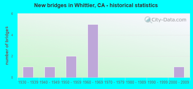
- New bridges - historical statistics
- 11930-1939
- 11940-1949
- 21950-1959
- 51960-1969
- 12000-2009

- Reconstructed bridges - Historical Statistics
- 11960-1969
- 11970-1979


- Bridge Condition - Deck
- 75.0%Good
- 25.0%Satisfactory

- Bridge Condition - Superstructure
- 75.0%Good
- 25.0%Satisfactory

- Bridge Condition - Channel
- 66.7%Very good
- 33.3%Good
Find on map >> Show street view
Structure Number: 53 0002, Location: 07-LA-101-34.82-AGRH (Lat: 34.145797, Lng: -118.757422), Route carried "on" structure: US 101, Year Built: 1949, Year Reconstructed: 1973, Status: Open, Structure Length: 3.26m (10.70ft), Average Daily Traffic: 160,000 (year 2018), Truck Traffic: 10%, Average Future Daily Traffic: 193,146 (year 2038), Design Load: HS 20, Features Intersected: MEDEA CREEK
Minimum Vertical Clearance: 30+ m (98+ ft), Kilometerpoint: 34.820, Lanes on structure: 10, Base Highway Network: Yes (Inventory Route: 1, Subroute: 1), Owner: State Highway Agency, Approaching Roadway Width: 53.0m (173.9ft), Skew: 30 degrees, Material/Design: Concrete continuous, Design/Construction: Slab, Number Of Spans In Main Unit: 4, Length of Maximum Span: 7.9m (25.9ft), Curb-To-Curb Width: 53.0m (173.9ft), Out-to-Out Width: 54.3m (178.1ft)
Condition: Deck: Good, Superstructure: Good, Substructure: Good, Channel: Good, Operating Rating: 60.9 metric tons, Method Used To Determine Operating Rating: Load Factor (LF), Inventory Rating: 36.6 metric tons, Method Used To Determine Inventory Rating: Load Factor (LF), Structural Evaluation: Better than present minimum criteria, Deck Geometry: Superior to present desirable criteria, Waterway Adequacy: Better than present minimum criteria, Approach Roadway Alignment: Equal to present desirable criteria, Designated Inspection Frequency: Every 48 months, Inspection Date: May 2020, Deck Structure Type: Concrete Cast-file-Place, Wearing Surface/Protective System: Wearing Surface: Monolithic Concrete
Find on map >> Show street view
Structure Number: 53 1501, Location: 07-LA-405-46.74-LA (Lat: 34.264383, Lng: -118.471911), Route carried "on" structure: Interstate 405, Year Built: 1963, Year Reconstructed: 1977, Status: Open, Structure Length: 4.54m (14.90ft), Average Daily Traffic: 209,000 (year 2019), Truck Traffic: 10%, Average Future Daily Traffic: 270,154 (year 2038), Design Load: HS 20, Features Intersected: CHATSWORTH STREET
Minimum Vertical Clearance: 30+ m (98+ ft), Kilometerpoint: 46.740, Lanes on structure: 12, Lanes under structure: 4, Base Highway Network: Yes (Inventory Route: 4, Subroute: 1), Owner: State Highway Agency, Approaching Roadway Width: 53.0m (173.9ft), Skew: 30 degrees, Material/Design: Prestressed concrete, Design/Construction: Box Beam or Girders - Multiple, Number Of Spans In Main Unit: 3, Length of Maximum Span: 27.4m (89.9ft), Curb-To-Curb Width: 51.2m (168.0ft), Out-to-Out Width: 53.3m (174.9ft)
Condition: Deck: Good, Superstructure: Good, Substructure: Good, Operating Rating: 53.5 metric tons, Method Used To Determine Operating Rating: Load Factor (LF), Inventory Rating: 32.6 metric tons, Method Used To Determine Inventory Rating: Load Factor (LF), Structural Evaluation: Better than present minimum criteria, Deck Geometry: Better than present minimum criteria, Underclear: Somewhat better than minimum adequacy, Approach Roadway Alignment: Equal to present desirable criteria, Designated Inspection Frequency: Every 24 months, Inspection Date: June 2021, Deck Structure Type: Concrete Cast-file-Place, Wearing Surface/Protective System: Wearing Surface: Monolithic Concrete
Find on map >> Show street view
Structure Number: 53 1509, Location: 07-LA-605-R13.55-WIT (Lat: 33.993053, Lng: -118.069092), Route carried "on" structure: Interstate 605, Year Built: 1964, Status: Open, Structure Length: 5.67m (18.60ft), Average Daily Traffic: 264,000 (year 2015), Truck Traffic: 11%, Average Future Daily Traffic: 268,410 (year 2040), Design Load: HS 20, Features Intersected: STATE ROUTE 72
Minimum Vertical Clearance: 30+ m (98+ ft), Kilometerpoint: 13.550, Lanes on structure: 12, Lanes under structure: 6, Base Highway Network: Yes (Inventory Route: 6, Subroute: 3), Owner: State Highway Agency, Approaching Roadway Width: 42.6m (139.8ft), Skew: 32 degrees, Material/Design: Concrete continuous, Design/Construction: Box Beam or Girders - Multiple, Number Of Spans In Main Unit: 4, Length of Maximum Span: 18.6m (61.0ft), Curb or Sidewalk Widths: Left: 0.6m (2.0ft), Right: 0.6m (2.0ft), Curb-To-Curb Width: 42.6m (139.8ft), Out-to-Out Width: 45.1m (148.0ft)
Condition: Deck: Good, Superstructure: Good, Substructure: Good, Operating Rating: 39.2 metric tons, Method Used To Determine Operating Rating: Load and Resistance Factor Rating (LRFR) rating reported by rating factor(RF) method using HL-93 loadings, Inventory Rating: 30.1 metric tons, Method Used To Determine Inventory Rating: Load and Resistance Factor Rating (LRFR) rating reported by rating factor(RF) method using HL-93 loadings, Structural Evaluation: Better than present minimum criteria, Deck Geometry: High priority of replacement, Underclear: Meets minimum limits, Approach Roadway Alignment: Equal to present desirable criteria, Designated Inspection Frequency: Every 24 months, Inspection Date: March 2020, Deck Structure Type: Concrete Cast-file-Place
Find on map >> Show street view
Structure Number: 53C1636, Location: 0.1MI E/O TIGRINA AVE (Lat: 33.928892, Lng: -117.980344), Route carried "on" structure: City street , Year Built: 1955, Status: Open, Structure Length: 0.65m (2.13ft), Average Daily Traffic: 202 (year 2014), Truck Traffic: 2%, Average Future Daily Traffic: 202 (year 2042), Features Intersected: LA MIRADA CRK, Facility Carried by Structure: HEATHFIELD DR
Minimum Vertical Clearance: 30.47m (99.97ft), Kilometerpoint: 0.000, Lanes on structure: 2, Owner: City or Municipal Highway Agency, Approaching Roadway Width: 9.8m (32.2ft), Skew: 3 degrees, Material/Design: Concrete, Design/Construction: Culvert, Number Of Spans In Main Unit: 2, Length of Maximum Span: 3.1m (10.2ft), Curb or Sidewalk Widths: Left: 3.0m (9.8ft), Right: 3.0m (9.8ft), Curb-To-Curb Width: 9.8m (32.2ft), Out-to-Out Width: 17.5m (57.4ft)
Condition: Channel: Very good, Culverts: Good, Operating Rating: 39.5 metric tons, Method Used To Determine Operating Rating: Load Factor (LF), Inventory Rating: 23.7 metric tons, Method Used To Determine Inventory Rating: Load Factor (LF), Structural Evaluation: Equal to present minimum criteria, Deck Geometry: Better than present minimum criteria, Waterway Adequacy: Equal to present desirable criteria, Approach Roadway Alignment: Equal to present desirable criteria, Designated Inspection Frequency: Every 24 months, Inspection Date: September 2021
Find on map >> Show street view
Structure Number: 53C2302, Location: 07-LA-072-6.86-PRV (Lat: 33.995828, Lng: -118.072819), Route carried "on" structure: City street , Year Built: 1968, Status: Open, Structure Length: 11.49m (37.70ft), Average Daily Traffic: 34,000 (year 2011), Average Future Daily Traffic: 42,301 (year 2040), Design Load: HS 20+Mod, Features Intersected: SAN GABRIEL RIV, Facility Carried by Structure: WHITTIER BLVD
Minimum Vertical Clearance: 30.47m (99.97ft), Kilometerpoint: 0.000, Lanes on structure: 4, Owner: City or Municipal Highway Agency, Approaching Roadway Width: 17.1m (56.1ft), Skew: 2 degrees, Material/Design: Prestressed concrete continuous, Design/Construction: Stringer/Multi-beam, Number Of Spans In Main Unit: 5, Length of Maximum Span: 22.9m (75.1ft), Curb or Sidewalk Widths: Left: 1.5m (4.9ft), Right: 1.5m (4.9ft), Curb-To-Curb Width: 25.6m (84.0ft), Out-to-Out Width: 29.3m (96.1ft)
Condition: Deck: Satisfactory, Superstructure: Satisfactory, Substructure: Good, Channel: Very good, Operating Rating: 54.1 metric tons, Method Used To Determine Operating Rating: Field evaluation and documented engineering judgment, Inventory Rating: 32.4 metric tons, Method Used To Determine Inventory Rating: Field evaluation and documented engineering judgment, Structural Evaluation: Equal to present minimum criteria, Deck Geometry: Superior to present desirable criteria, Waterway Adequacy: Equal to present desirable criteria, Approach Roadway Alignment: Superior to present desirable criteria, Designated Inspection Frequency: Every 48 months, Inspection Date: September 2020, Deck Structure Type: Concrete Cast-file-Place, Wearing Surface/Protective System: Wearing Surface: Monolithic Concrete
Find on map >> Show street view
Structure Number: 53 0007, Location: 07-LA-072-4.24-WIT (Lat: 33.967592, Lng: -118.041172), Route carried "under" structure: State highway 72, Year Built: 1930, Structure Length: 0. m, Average Daily Traffic: 44,100 (year 2010), Features Intersected: SR 72 (WHITTIER BLVD), Facility Carried by Structure: BIKE TRAIL
Minimum Vertical Clearance: 4.47m (14.67ft), Kilometerpoint: 4.240, Lanes under structure: 7, Material/Design: Steel, Design/Construction: Slab, Length of Maximum Span: 57.6m (189.0ft)
Find on map >> Show street view
Structure Number: 53 1509, Location: 07-LA-605-R13.55-WIT (Lat: 33.993053, Lng: -118.069092), Route carried "under" structure: State highway 72, Year Built: 1964, Structure Length: 0. m, Average Daily Traffic: 40,000 (year 2012), Truck Traffic: 4%, Features Intersected: STATE ROUTE 72, Facility Carried by Structure: INTERSTATE 605
Minimum Vertical Clearance: 4.78m (15.68ft), Kilometerpoint: 6.660, Lanes on structure: 12, Lanes under structure: 6, Material/Design: Concrete continuous, Design/Construction: Box Beam or Girders - Multiple, Length of Maximum Span: 18.6m (61.0ft)
Find on map >> Show street view
Structure Number: 53C0455, Location: 0.5MI N/O WHITTIER BLVD (Lat: 33.994133, Lng: -118.059644), Route carried "under" structure: City street L094, Year Built: 1966, Structure Length: 0. m, Average Daily Traffic: 19,240 (year 2012), Truck Traffic: 2%, Features Intersected: NORWALK BLVD, Facility Carried by Structure: WHITT GRNWY TR POC
Minimum Vertical Clearance: 4.62m (15.16ft), Kilometerpoint: 0.000, Lanes under structure: 5, Material/Design: Steel, Design/Construction: Girder and Floorbeam System, Length of Maximum Span: 25.9m (85.0ft)
Find on map >> Show street view
Structure Number: 53C2236, Location: 50FT N/O WHITTIER BLVD (Lat: 33.967594, Lng: -118.041169), Route carried "under" structure: City street , Year Built: 2009, Structure Length: 0. m, Average Daily Traffic: 10,302 (year 2012), Truck Traffic: 2%, Features Intersected: PICKERING AVE, Facility Carried by Structure: WHITT GRNWY TR POC
Minimum Vertical Clearance: 4.50m (14.76ft), Kilometerpoint: 0.000, Lanes under structure: 2, Material/Design: Steel, Design/Construction: Truss - Thru, Length of Maximum Span: 42.3m (138.8ft)
Find on map >> Show street view
Structure Number: 53C2304, Location: 0.1MI W/O ESPERANZA AVE (Lat: 33.994861, Lng: -118.071556), Route carried "under" structure: City street , Year Built: 1953, Structure Length: 0. m, Average Daily Traffic: 44,100 (year 2010), Truck Traffic: 5%, Features Intersected: WHITTIER BLVD, Facility Carried by Structure: UPRR
Minimum Vertical Clearance: 4.57m (14.99ft), Kilometerpoint: 0.000, Lanes under structure: 4, Material/Design: Steel, Design/Construction: Slab, Length of Maximum Span: 26.1m (85.6ft)