Bridge Statistics for West Milford, New Jersey (NJ)
Condition, Traffic, Stress, Structural Evaluation, Project Costs
- National Bridge Inventory (NBI) Statistics
- 20Number of bridges
- 121ft / 37.2mTotal length
- $10,586,000Total costs
- 217,333Total average daily traffic
- 8,453Total average daily truck traffic
- 263,605Total future (year 2040) average daily traffic
- National Bridge Inventory (NBI) Registered Bridges for West Milford
- No street view available for this location
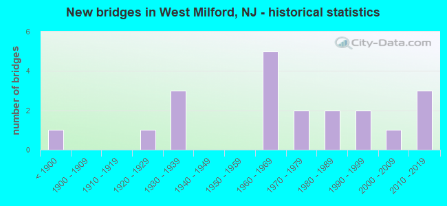
- New bridges - historical statistics
- 1Before 1900
- 11920-1929
- 31930-1939
- 51960-1969
- 21970-1979
- 21980-1989
- 21990-1999
- 12000-2009
- 32010-2019
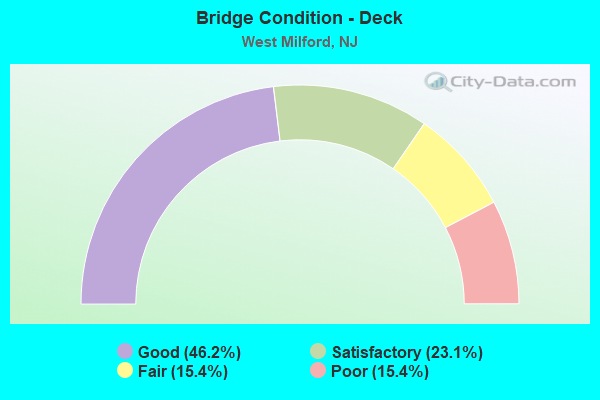
- Bridge Condition - Deck
- 46.2%Good
- 23.1%Satisfactory
- 15.4%Fair
- 15.4%Poor
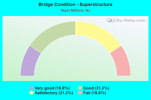
- Bridge Condition - Superstructure
- 18.8%Very good
- 31.3%Good
- 31.3%Satisfactory
- 18.8%Fair
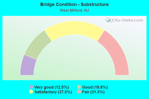
- Bridge Condition - Substructure
- 12.5%Very good
- 18.8%Good
- 37.5%Satisfactory
- 31.3%Fair
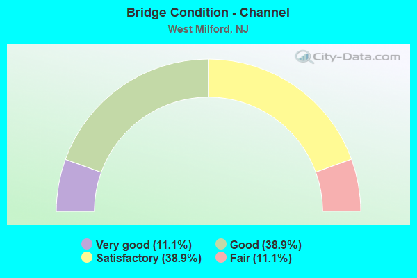
- Bridge Condition - Channel
- 11.1%Very good
- 38.9%Good
- 38.9%Satisfactory
- 11.1%Fair
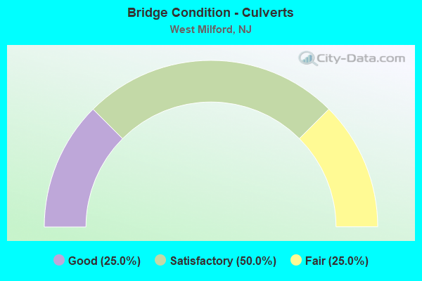
- Bridge Condition - Culverts
- 25.0%Good
- 50.0%Satisfactory
- 25.0%Fair
Find on map >> Show street view
Structure Number: 1400323, Location: 0.4 MILE SOUTH OF NJ 23 (Lat: 41.050011, Lng: -74.464831), Route carried "on" structure: City street , Year Built: 2016, Status: Open, Structure Length: 1.83m (6.00ft), Average Daily Traffic: 3,567 (year 2021), Truck Traffic: 3%, Average Future Daily Traffic: 4,244 (year 2041), Design Load: HS 20+Mod, Features Intersected: PEQUANNOCK RIVER, Facility Carried by Structure: COZY LAKE ROAD
Minimum Vertical Clearance: 30+ m (98+ ft), Kilometerpoint: 0.000, Lanes on structure: 2, Owner: County Highway Agency, Approaching Roadway Width: 7.6m (24.9ft), Material/Design: Concrete, Design/Construction: Arch - Deck, Number Of Spans In Main Unit: 1, Length of Maximum Span: 18.3m (60.0ft), Curb or Sidewalk Widths: Left: 0.2m (0.7ft), Right: 0.2m (0.7ft), Curb-To-Curb Width: 7.6m (24.9ft), Out-to-Out Width: 9.2m (30.2ft)
Condition: Superstructure: Good, Substructure: Very good, Channel: Good, Structural Evaluation: Better than present minimum criteria, Deck Geometry: High priority of replacement, Waterway Adequacy: Equal to present desirable criteria, Approach Roadway Alignment: Equal to present minimum criteria, Length Of Structure Improvement: 1.83m (6.00ft), Designated Inspection Frequency: Every 24 months, Inspection Date: August 2021, Bridge Improvement Cost: $14,860,000, Roadway Improvement Cost: $628,000, Total Project Cost: $2,314,000 ( Estimate for 2015)
Find on map >> Show street view
Structure Number: 1600049, Location: 2.2MI N OF GRNWD TPK(511) (Lat: 41.160050, Lng: -74.330519), Route carried "on" structure: County highway 704, Year Built: 1961, Status: Open, Structure Length: 2.19m (7.19ft), Average Daily Traffic: 975 (year 2021), Truck Traffic: 3%, Average Future Daily Traffic: 1,190 (year 2041), Design Load: H 20, Features Intersected: WANAQUE RIVER
Minimum Vertical Clearance: 30+ m (98+ ft), Kilometerpoint: 4.023, Lanes on structure: 2, Owner: County Highway Agency, Approaching Roadway Width: 9.1m (29.9ft), Skew: 3 degrees, Material/Design: Steel, Design/Construction: Stringer/Multi-beam, Number Of Spans In Main Unit: 1, Length of Maximum Span: 20.4m (66.9ft), Curb or Sidewalk Widths: Left: 1.8m (5.9ft), Right: 0.6m (2.0ft), Curb-To-Curb Width: 9.1m (29.9ft), Out-to-Out Width: 12.2m (40.0ft)
Condition: Deck: Satisfactory, Superstructure: Fair, Substructure: Satisfactory, Channel: Good, Operating Rating: 83.5 metric tons, Method Used To Determine Operating Rating: Load Factor (LF), Inventory Rating: 49.9 metric tons, Method Used To Determine Inventory Rating: Load Factor (LF), Structural Evaluation: Somewhat better than minimum adequacy, Deck Geometry: Equal to present minimum criteria, Waterway Adequacy: Superior to present desirable criteria, Approach Roadway Alignment: Equal to present minimum criteria, Designated Inspection Frequency: Every 24 months, Inspection Date: April 2021, Deck Structure Type: Concrete Cast-file-Place, Wearing Surface/Protective System: Wearing Surface: Bituminous, Membrane: Preformed Fabric
Find on map >> Show street view
Structure Number: 1600175, Location: 3.7 MI N OF NJ 23 (Lat: 41.097250, Lng: -74.442111), Route carried "on" structure: City street , Year Built: 2016, Status: Open, Structure Length: 1.74m (5.71ft), Average Daily Traffic: 193 (year 2021), Truck Traffic: 3%, Average Future Daily Traffic: 235 (year 2041), Design Load: HL 93, Features Intersected: MOSSMAN'S BROOK, Facility Carried by Structure: CLINTON ROAD
Minimum Vertical Clearance: 30+ m (98+ ft), Kilometerpoint: 0.000, Lanes on structure: 2, Owner: County Highway Agency, Approaching Roadway Width: 8.5m (27.9ft), Material/Design: Concrete, Design/Construction: Arch - Deck, Number Of Spans In Main Unit: 1, Length of Maximum Span: 16.5m (54.1ft), Curb-To-Curb Width: 8.6m (28.2ft), Out-to-Out Width: 11.0m (36.1ft)
Condition: Superstructure: Very good, Substructure: Very good, Channel: Fair, Operating Rating: 96.9 metric tons, Method Used To Determine Operating Rating: Load and Resistance Factor Rating (LRFR) rating reported by rating factor(RF) method using HL-93 loadings, Inventory Rating: 96.9 metric tons, Method Used To Determine Inventory Rating: Load and Resistance Factor Rating (LRFR) rating reported by rating factor(RF) method using HL-93 loadings, Structural Evaluation: Equal to present desirable criteria, Deck Geometry: Equal to present minimum criteria, Waterway Adequacy: Better than present minimum criteria, Approach Roadway Alignment: Equal to present minimum criteria, Length Of Structure Improvement: 1.34m (4.40ft), Designated Inspection Frequency: Every 24 months, Inspection Date: March 2021, Bridge Improvement Cost: $537,000, Roadway Improvement Cost: $100,000, Total Project Cost: $1,005,000 ( Estimate for 2015)
Find on map >> Show street view
Structure Number: 1600247, Location: South of Route 511 (Lat: 41.137919, Lng: -74.324350), Route carried "on" structure: City street , Year Built: 1983, Status: Open, Structure Length: 0.82m (2.69ft), Average Daily Traffic: 583 (year 2021), Truck Traffic: 1%, Average Future Daily Traffic: 712 (year 2041), Design Load: HS 20, Features Intersected: Trib. of Hewitt Brook, Facility Carried by Structure: Burnt Meadow Road
Minimum Vertical Clearance: 30+ m (98+ ft), Kilometerpoint: 0.000, Lanes on structure: 2, Owner: County Highway Agency, Approaching Roadway Width: 6.1m (20.0ft), Material/Design: Concrete, Design/Construction: Culvert, Number Of Spans In Main Unit: 3, Length of Maximum Span: 1.8m (5.9ft), Curb-To-Curb Width: 5.6m (18.4ft), Out-to-Out Width: 8.5m (27.9ft)
Condition: Channel: Satisfactory, Culverts: Fair, Operating Rating: 51.7 metric tons, Method Used To Determine Operating Rating: Load Factor (LF), Inventory Rating: 30.8 metric tons, Method Used To Determine Inventory Rating: Load Factor (LF), Structural Evaluation: Somewhat better than minimum adequacy, Deck Geometry: High priority of replacement, Waterway Adequacy: Equal to present minimum criteria, Approach Roadway Alignment: Equal to present minimum criteria, Length Of Structure Improvement: 0.82m (2.69ft), Designated Inspection Frequency: Every 24 months, Inspection Date: March 2021, Bridge Improvement Cost: $200,000, Roadway Improvement Cost: $20,000, Total Project Cost: $276,000 ( Estimate for 2021)
Find on map >> Show street view
Structure Number: 1600305, Location: 0.9 mi E of CR696 (Lat: 41.139850, Lng: -74.328400), Route carried "on" structure: County highway 511, Year Built: 2006, Status: Open, Structure Length: 0.67m (2.20ft), Average Daily Traffic: 13,188 (year 2021), Truck Traffic: 4%, Average Future Daily Traffic: 16,092 (year 2041), Design Load: HL 93, Features Intersected: Trib. to Hewitt Brook, Facility Carried by Structure: Greenwood Lake Tpk
Minimum Vertical Clearance: 30+ m (98+ ft), Kilometerpoint: 52.706, Lanes on structure: 3, Owner: County Highway Agency, Approaching Roadway Width: 17.1m (56.1ft), Skew: 2 degrees, Material/Design: Concrete, Design/Construction: Culvert, Number Of Spans In Main Unit: 2, Length of Maximum Span: 3.4m (11.2ft), Curb-To-Curb Width: 18.5m (60.7ft), Out-to-Out Width: 19.5m (64.0ft)
Condition: Channel: Satisfactory, Culverts: Good, Structural Evaluation: Better than present minimum criteria, Deck Geometry: Superior to present desirable criteria, Waterway Adequacy: Better than present minimum criteria, Approach Roadway Alignment: Better than present minimum criteria, Designated Inspection Frequency: Every 24 months, Inspection Date: May 2021
Find on map >> Show street view
Structure Number: 1600368, Location: AT JCT OF WEST BROOK (Lat: 41.084561, Lng: -74.350531), Route carried "on" structure: City street , Year Built: 1997, Status: Open, Structure Length: 0.88m (2.89ft), Average Daily Traffic: 260 (year 2021), Truck Traffic: 1%, Average Future Daily Traffic: 317 (year 2041), Design Load: HS 20+Mod, Features Intersected: WEST BROOK, Facility Carried by Structure: SNAKE DEN ROAD
Minimum Vertical Clearance: 30+ m (98+ ft), Kilometerpoint: 0.000, Lanes on structure: 2, Owner: County Highway Agency, Approaching Roadway Width: 7.9m (25.9ft), Skew: 1 degrees, Material/Design: Prestressed concrete, Design/Construction: Slab, Number Of Spans In Main Unit: 1, Length of Maximum Span: 8.2m (26.9ft), Curb-To-Curb Width: 7.9m (25.9ft), Out-to-Out Width: 9.0m (29.5ft)
Condition: Deck: Good, Superstructure: Good, Substructure: Good, Channel: Satisfactory, Operating Rating: 89.8 metric tons, Method Used To Determine Operating Rating: Load Factor (LF), Inventory Rating: 70.8 metric tons, Method Used To Determine Inventory Rating: Load Factor (LF), Structural Evaluation: Better than present minimum criteria, Deck Geometry: Somewhat better than minimum adequacy, Waterway Adequacy: Equal to present desirable criteria, Approach Roadway Alignment: Somewhat better than minimum adequacy, Designated Inspection Frequency: Every 24 months, Inspection Date: March 2021, Deck Structure Type: Concrete Cast-file-Place, Wearing Surface/Protective System: Wearing Surface: Monolithic Concrete, Deck Protection: Epoxy Coated Reinforcing
Find on map >> Show street view
Structure Number: 160043, Location: 0.3 mi S. of Stoway Road (Lat: 41.119939, Lng: -74.382269), Route carried "on" structure: County highway 513, Year Built: 1850, Status: Open, Structure Length: 0.73m (2.40ft), Average Daily Traffic: 11,512 (year 2021), Truck Traffic: 4%, Average Future Daily Traffic: 14,047 (year 2041), Design Load: H 20, Features Intersected: Belcher's Creek, Facility Carried by Structure: Union Valley Road
Minimum Vertical Clearance: 30+ m (98+ ft), Kilometerpoint: 102.386, Lanes on structure: 2, Owner: County Highway Agency, Approaching Roadway Width: 7.3m (24.0ft), Material/Design: Masonry, Design/Construction: Arch - Deck, Number Of Spans In Main Unit: 1, Number Of Approach Spans: 1, Length of Maximum Span: 3.7m (12.1ft), Curb-To-Curb Width: 7.0m (23.0ft), Out-to-Out Width: 8.1m (26.6ft)
Condition: Superstructure: Fair, Substructure: Fair, Channel: Good, Operating Rating: 51.7 metric tons, Method Used To Determine Operating Rating: Field evaluation and documented engineering judgment, Inventory Rating: 30.8 metric tons, Method Used To Determine Inventory Rating: Field evaluation and documented engineering judgment, Structural Evaluation: Somewhat better than minimum adequacy, Deck Geometry: High priority of replacement, Waterway Adequacy: Equal to present minimum criteria, Approach Roadway Alignment: Equal to present desirable criteria, Length Of Structure Improvement: 1.40m (4.59ft), Designated Inspection Frequency: Every 24 months, Inspection Date: April 2021, Bridge Improvement Cost: $744,000, Roadway Improvement Cost: $112,000, Total Project Cost: $1,355,000 ( Estimate for 2021)
Find on map >> Show street view
Structure Number: 1600432, Location: 0.4 N OF MARSHLL HILL/696 (Lat: 41.137589, Lng: -74.367439), Route carried "on" structure: County highway 513, Year Built: 1970, Status: Open, Structure Length: 2.01m (6.59ft), Average Daily Traffic: 9,347 (year 2021), Truck Traffic: 4%, Average Future Daily Traffic: 11,405 (year 2041), Design Load: HS 20, Features Intersected: BELCHER'S CREEK
Minimum Vertical Clearance: 30+ m (98+ ft), Kilometerpoint: 104.897, Lanes on structure: 2, Owner: County Highway Agency, Approaching Roadway Width: 14.3m (46.9ft), Material/Design: Prestressed concrete, Design/Construction: Box Beam or Girders - Multiple, Number Of Spans In Main Unit: 1, Length of Maximum Span: 18.9m (62.0ft), Curb or Sidewalk Widths: Left: 1.5m (4.9ft), Right: 1.5m (4.9ft), Curb-To-Curb Width: 14.1m (46.3ft), Out-to-Out Width: 17.7m (58.1ft)
Condition: Deck: Satisfactory, Superstructure: Satisfactory, Substructure: Satisfactory, Channel: Satisfactory, Operating Rating: 50.8 metric tons, Method Used To Determine Operating Rating: Load Factor (LF), Inventory Rating: 30.8 metric tons, Method Used To Determine Inventory Rating: Load Factor (LF), Structural Evaluation: Equal to present minimum criteria, Deck Geometry: Superior to present desirable criteria, Waterway Adequacy: Superior to present desirable criteria, Approach Roadway Alignment: Equal to present desirable criteria, Designated Inspection Frequency: Every 24 months, Inspection Date: April 2021, Deck Structure Type: Other, Wearing Surface/Protective System: Wearing Surface: Bituminous
Find on map >> Show street view
Structure Number: 1600434, Location: 1.7 N OF MARSHLL HILL/696 (Lat: 41.152650, Lng: -74.359011), Route carried "on" structure: County highway 513, Year Built: 2011, Status: Open, Structure Length: 1.07m (3.51ft), Average Daily Traffic: 9,563 (year 2021), Truck Traffic: 4%, Average Future Daily Traffic: 11,669 (year 2041), Design Load: HS 25 or greater, Features Intersected: GREEN BROOK
Minimum Vertical Clearance: 30+ m (98+ ft), Kilometerpoint: 106.796, Lanes on structure: 2, Owner: County Highway Agency, Approaching Roadway Width: 11.0m (36.1ft), Material/Design: Steel, Design/Construction: Stringer/Multi-beam, Number Of Spans In Main Unit: 1, Length of Maximum Span: 9.1m (29.9ft), Curb or Sidewalk Widths: Left: 1.8m (5.9ft), Right: 1.8m (5.9ft), Curb-To-Curb Width: 11.0m (36.1ft), Out-to-Out Width: 15.5m (50.9ft)
Condition: Deck: Good, Superstructure: Very good, Substructure: Good, Channel: Good, Operating Rating: 89.8 metric tons, Method Used To Determine Operating Rating: Load Factor (LF), Inventory Rating: 89.8 metric tons, Method Used To Determine Inventory Rating: Load Factor (LF), Structural Evaluation: Better than present minimum criteria, Deck Geometry: Meets minimum limits, Waterway Adequacy: Better than present minimum criteria, Approach Roadway Alignment: Equal to present desirable criteria, Designated Inspection Frequency: Every 24 months, Inspection Date: March 2021, Deck Structure Type: Concrete Cast-file-Place, Wearing Surface/Protective System: Wearing Surface: Monolithic Concrete, Deck Protection: Galvanized Reinforcing
Find on map >> Show street view
Structure Number: 1600446, Location: 0.35 MI N of CR 513 (Lat: 41.155500, Lng: -74.362481), Route carried "on" structure: City street , Year Built: 1935, Status: Open, Structure Length: 0.67m (2.20ft), Average Daily Traffic: 12,641 (year 2021), Truck Traffic: 3%, Average Future Daily Traffic: 15,424 (year 2041), Features Intersected: Green Brook, Facility Carried by Structure: Warwick Turnpike
Minimum Vertical Clearance: 30+ m (98+ ft), Kilometerpoint: 0.563, Lanes on structure: 2, Owner: County Highway Agency, Approaching Roadway Width: 9.4m (30.8ft), Skew: 3 degrees, Material/Design: Concrete, Design/Construction: Slab, Number Of Spans In Main Unit: 1, Length of Maximum Span: 6.4m (21.0ft), Curb-To-Curb Width: 9.4m (30.8ft), Out-to-Out Width: 10.0m (32.8ft)
Condition: Deck: Good, Superstructure: Satisfactory, Substructure: Satisfactory, Channel: Good, Operating Rating: 38.1 metric tons, Method Used To Determine Operating Rating: Load Factor (LF), Inventory Rating: 22.7 metric tons, Method Used To Determine Inventory Rating: Load Factor (LF), Structural Evaluation: Somewhat better than minimum adequacy, Deck Geometry: High priority of corrective action, Waterway Adequacy: Better than present minimum criteria, Approach Roadway Alignment: Equal to present minimum criteria, Length Of Structure Improvement: 1.28m (4.20ft), Designated Inspection Frequency: Every 24 months, Inspection Date: May 2021, Bridge Improvement Cost: $660,000, Roadway Improvement Cost: $112,000, Total Project Cost: $1,220,000 ( Estimate for 2021), Deck Structure Type: Concrete Cast-file-Place, Wearing Surface/Protective System: Wearing Surface: Bituminous
Find on map >> Show street view
Structure Number: 160046, Location: 0.8 MI E OF SNAKE DEN RD (Lat: 41.087239, Lng: -74.337381), Route carried "on" structure: City street , Year Built: 1936, Year Reconstructed: 1995, Status: Open, Structure Length: 0.82m (2.69ft), Average Daily Traffic: 2,040 (year 2021), Truck Traffic: 4%, Average Future Daily Traffic: 2,489 (year 2041), Design Load: HS 20+Mod, Features Intersected: WEST BROOK, Facility Carried by Structure: WEST BROOK ROAD
Minimum Vertical Clearance: 30+ m (98+ ft), Kilometerpoint: 5.955, Lanes on structure: 2, Owner: County Highway Agency, Approaching Roadway Width: 8.8m (28.9ft), Skew: 2 degrees, Material/Design: Prestressed concrete, Design/Construction: Box Beam or Girders - Multiple, Number Of Spans In Main Unit: 1, Length of Maximum Span: 7.0m (23.0ft), Curb-To-Curb Width: 8.9m (29.2ft), Out-to-Out Width: 10.0m (32.8ft)
Condition: Deck: Good, Superstructure: Good, Substructure: Satisfactory, Channel: Satisfactory, Operating Rating: 89.8 metric tons, Method Used To Determine Operating Rating: Load Factor (LF), Inventory Rating: 53.5 metric tons, Method Used To Determine Inventory Rating: Load Factor (LF), Structural Evaluation: Equal to present minimum criteria, Deck Geometry: Meets minimum limits, Waterway Adequacy: Superior to present desirable criteria, Approach Roadway Alignment: Equal to present minimum criteria, Length Of Structure Improvement: 0.82m (2.69ft), Designated Inspection Frequency: Every 24 months, Inspection Date: April 2021, Bridge Improvement Cost: $268,000, Total Project Cost: $268,000 ( Estimate for 2021), Deck Structure Type: Concrete Cast-file-Place, Wearing Surface/Protective System: Wearing Surface: Monolithic Concrete, Deck Protection: Epoxy Coated Reinforcing
Find on map >> Show street view
Structure Number: 1600467, Location: 2.0 MI N of Warwick Tpk (Lat: 41.186339, Lng: -74.370619), Route carried "on" structure: City street , Year Built: 1935, Year Reconstructed: 1990, Status: Open, Structure Length: 0.85m (2.79ft), Average Daily Traffic: 1,061 (year 2021), Truck Traffic: 1%, Average Future Daily Traffic: 1,294 (year 2041), Features Intersected: Trib. Long House Creek, Facility Carried by Structure: Lake Shore Drive
Minimum Vertical Clearance: 30+ m (98+ ft), Kilometerpoint: 0.000, Lanes on structure: 2, Owner: County Highway Agency, Approaching Roadway Width: 7.6m (24.9ft), Material/Design: Prestressed concrete, Design/Construction: Slab, Number Of Spans In Main Unit: 1, Length of Maximum Span: 7.6m (24.9ft), Curb or Sidewalk Widths: Left: 1.2m (3.9ft), Right: 1.2m (3.9ft), Curb-To-Curb Width: 7.5m (24.6ft), Out-to-Out Width: 10.5m (34.4ft)
Condition: Deck: Satisfactory, Superstructure: Good, Substructure: Good, Channel: Very good, Operating Rating: 89.8 metric tons, Method Used To Determine Operating Rating: Load Factor (LF), Inventory Rating: 53.5 metric tons, Method Used To Determine Inventory Rating: Load Factor (LF), Structural Evaluation: Better than present minimum criteria, Deck Geometry: Meets minimum limits, Waterway Adequacy: Better than present minimum criteria, Approach Roadway Alignment: Equal to present minimum criteria, Designated Inspection Frequency: Every 24 months, Inspection Date: May 2021, Deck Structure Type: Other, Wearing Surface/Protective System: Wearing Surface: Bituminous, Membrane: Preformed Fabric
Find on map >> Show street view
Structure Number: 1600513, Location: 1400 FT.N.OF BEECH ROAD (Lat: 41.138781, Lng: -74.304950), Route carried "on" structure: County highway 511, Year Built: 1986, Status: Open, Structure Length: 3.41m (11.19ft), Average Daily Traffic: 13,823 (year 2021), Truck Traffic: 4%, Average Future Daily Traffic: 16,867 (year 2041), Design Load: HS 20+Mod, Features Intersected: MONKSVILLE RESERVOIR, Facility Carried by Structure: GREENWOOD LK TNPK
Minimum Vertical Clearance: 30+ m (98+ ft), Kilometerpoint: 50.485, Lanes on structure: 2, Owner: County Highway Agency, Approaching Roadway Width: 13.4m (44.0ft), Material/Design: Prestressed concrete, Design/Construction: Box Beam or Girders - Multiple, Number Of Spans In Main Unit: 2, Length of Maximum Span: 15.5m (50.9ft), Curb or Sidewalk Widths: Left: 0.2m (0.7ft), Right: 0.2m (0.7ft), Curb-To-Curb Width: 13.4m (44.0ft), Out-to-Out Width: 14.6m (47.9ft)
Condition: Deck: Poor, Superstructure: Satisfactory, Substructure: Fair, Channel: Very good, Operating Rating: 64.4 metric tons, Method Used To Determine Operating Rating: Load Factor (LF), Inventory Rating: 38.1 metric tons, Method Used To Determine Inventory Rating: Load Factor (LF), Structural Evaluation: Somewhat better than minimum adequacy, Deck Geometry: Equal to present minimum criteria, Waterway Adequacy: Equal to present desirable criteria, Approach Roadway Alignment: Equal to present desirable criteria, Length Of Structure Improvement: 3.41m (11.19ft), Designated Inspection Frequency: Every 24 months, Underwater Inspection Frequency: Every 48 months, Inspection Date: April 2021, Underwater Inspection Date: June 2019, Bridge Improvement Cost: $1,027,000, Roadway Improvement Cost: $55,000, Total Project Cost: $1,658,000 ( Estimate for 2021), Deck Structure Type: Concrete Cast-file-Place, Wearing Surface/Protective System: Wearing Surface: Bituminous, Deck Protection: Epoxy Coated Reinforcing
Find on map >> Show street view
Structure Number: 1605158, Location: 0.9M S OF ECHO LAKE ROAD (Lat: 41.026100, Lng: -74.408219), Route carried "on" structure: State highway 23, Year Built: 1924, Year Reconstructed: 1990, Status: Open, Structure Length: 1.68m (5.51ft), Average Daily Traffic: 39,400 (year 2020), Truck Traffic: 4%, Average Future Daily Traffic: 47,000 (year 2040), Design Load: HS 20+Mod, Features Intersected: MACOPIN RIVER
Minimum Vertical Clearance: 30+ m (98+ ft), Kilometerpoint: 31.382, Lanes on structure: 2, Base Highway Network: Yes, Owner: State Highway Agency, Approaching Roadway Width: 11.3m (37.1ft), Skew: 4 degrees, Material/Design: Steel, Design/Construction: Stringer/Multi-beam, Number Of Spans In Main Unit: 1, Length of Maximum Span: 14.9m (48.9ft), Curb or Sidewalk Widths: Left: 0.0m, Right: 1.8m (5.9ft), Curb-To-Curb Width: 11.3m (37.1ft), Out-to-Out Width: 13.9m (45.6ft)
Condition: Deck: Good, Superstructure: Good, Substructure: Satisfactory, Channel: Good, Operating Rating: 86.2 metric tons, Method Used To Determine Operating Rating: Load Factor (LF), Inventory Rating: 51.7 metric tons, Method Used To Determine Inventory Rating: Load Factor (LF), Structural Evaluation: Equal to present minimum criteria, Deck Geometry: Equal to present minimum criteria, Waterway Adequacy: Superior to present desirable criteria, Approach Roadway Alignment: Better than present minimum criteria, Length Of Structure Improvement: 1.68m (5.51ft), Designated Inspection Frequency: Every 24 months, Inspection Date: August 2020, Bridge Improvement Cost: $320,000, Total Project Cost: $320,000 ( Estimate for 2020), Deck Structure Type: Concrete Cast-file-Place, Wearing Surface/Protective System: Deck Protection: Epoxy Coated Reinforcing
Find on map >> Show street view
Structure Number: 1605161, Location: 0.13 MI S OF CR 513 (Lat: 41.048419, Lng: -74.441769), Route carried "on" structure: State highway 23, Year Built: 1995, Status: Open, Structure Length: 3.17m (10.40ft), Average Daily Traffic: 19,913 (year 2021), Truck Traffic: 4%, Average Future Daily Traffic: 23,896 (year 2041), Design Load: HS 20, Features Intersected: CLINTON BROOK
Minimum Vertical Clearance: 30+ m (98+ ft), Kilometerpoint: 35.309, Lanes on structure: 2, Base Highway Network: Yes, Owner: State Highway Agency, Approaching Roadway Width: 14.3m (46.9ft), Skew: 2 degrees, Material/Design: Steel continuous, Design/Construction: Stringer/Multi-beam, Number Of Spans In Main Unit: 2, Length of Maximum Span: 14.9m (48.9ft), Curb or Sidewalk Widths: Left: 1.8m (5.9ft), Right: 0.0m, Curb-To-Curb Width: 14.3m (46.9ft), Out-to-Out Width: 17.0m (55.8ft)
Condition: Deck: Good, Superstructure: Very good, Substructure: Satisfactory, Channel: Good, Inventory Rating: 63.5 metric tons, Method Used To Determine Inventory Rating: Load Factor (LF), Structural Evaluation: Equal to present minimum criteria, Deck Geometry: Superior to present desirable criteria, Waterway Adequacy: Better than present minimum criteria, Approach Roadway Alignment: Equal to present desirable criteria, Designated Inspection Frequency: Every 24 months, Inspection Date: May 2021, Deck Structure Type: Concrete Cast-file-Place, Wearing Surface/Protective System: Deck Protection: Epoxy Coated Reinforcing
Find on map >> Show street view
Structure Number: 1605164, Location: 11.5 Mi. N. of RT 287 (Lat: 41.062569, Lng: -74.482231), Route carried "on" structure: State highway 23, Year Built: 1969, Status: Open, Structure Length: 5.30m (17.39ft), Average Daily Traffic: 12,110 (year 2020), Truck Traffic: 4%, Average Future Daily Traffic: 14,775 (year 2040), Design Load: HS 20+Mod, Features Intersected: NYS&W RR
Minimum Vertical Clearance: 30+ m (98+ ft), Kilometerpoint: 39.188, Lanes on structure: 2, Base Highway Network: Yes, Owner: State Highway Agency, Approaching Roadway Width: 12.2m (40.0ft), Skew: 5 degrees, Material/Design: Steel, Design/Construction: Stringer/Multi-beam, Number Of Spans In Main Unit: 3, Length of Maximum Span: 17.4m (57.1ft), Curb or Sidewalk Widths: Left: 0.5m (1.6ft), Right: 1.8m (5.9ft), Curb-To-Curb Width: 12.2m (40.0ft), Out-to-Out Width: 15.2m (49.9ft)
Condition: Deck: Fair, Superstructure: Satisfactory, Substructure: Fair, Inventory Rating: 56.2 metric tons, Method Used To Determine Inventory Rating: Load Factor (LF), Structural Evaluation: Somewhat better than minimum adequacy, Deck Geometry: Better than present minimum criteria, Underclear: Somewhat better than minimum adequacy, Approach Roadway Alignment: Equal to present desirable criteria, Designated Inspection Frequency: Every 24 months, Inspection Date: April 2020, Deck Structure Type: Concrete Cast-file-Place, Wearing Surface/Protective System: Wearing Surface: Bituminous
Find on map >> Show street view
Structure Number: 1605166, Location: 3.4 MI. N. OF C.R. 513 (Lat: 41.075339, Lng: -74.487489), Route carried "on" structure: State highway 23, Year Built: 1969, Status: Open, Structure Length: 2.04m (6.69ft), Average Daily Traffic: 24,465 (year 2021), Truck Traffic: 4%, Average Future Daily Traffic: 29,852 (year 2041), Design Load: HS 20, Features Intersected: PEQUANNOCK RIVER
Minimum Vertical Clearance: 30+ m (98+ ft), Kilometerpoint: 40.716, Lanes on structure: 4, Base Highway Network: Yes, Owner: State Highway Agency, Approaching Roadway Width: 22.9m (75.1ft), Skew: 24 degrees, Material/Design: Concrete, Design/Construction: Culvert, Number Of Spans In Main Unit: 2, Length of Maximum Span: 10.1m (33.1ft)
Condition: Channel: Fair, Culverts: Satisfactory, Operating Rating: 33.6 metric tons, Method Used To Determine Operating Rating: Load Factor (LF), Inventory Rating: 20.0 metric tons, Method Used To Determine Inventory Rating: Load Factor (LF), Structural Evaluation: Somewhat better than minimum adequacy, Waterway Adequacy: Superior to present desirable criteria, Approach Roadway Alignment: Equal to present desirable criteria, Designated Inspection Frequency: Every 24 months, Inspection Date: Febuary 2021
Find on map >> Show street view
Structure Number: 160517, Location: 0.1 Mi N. of C.R. 513 (Lat: 41.049711, Lng: -74.441811), Route carried "on" structure: State highway 23, Year Built: 1964, Status: Open, Structure Length: 1.77m (5.81ft), Average Daily Traffic: 18,350 (year 2020), Truck Traffic: 4%, Average Future Daily Traffic: 22,397 (year 2040), Design Load: HS 20+Mod, Features Intersected: CLINTON BROOK
Minimum Vertical Clearance: 30+ m (98+ ft), Kilometerpoint: 35.309, Lanes on structure: 2, Base Highway Network: Yes, Owner: State Highway Agency, Approaching Roadway Width: 11.3m (37.1ft), Skew: 4 degrees, Material/Design: Prestressed concrete, Design/Construction: Box Beam or Girders - Multiple, Number Of Spans In Main Unit: 1, Length of Maximum Span: 15.8m (51.8ft), Curb or Sidewalk Widths: Left: 0.5m (1.6ft), Right: 1.2m (3.9ft), Curb-To-Curb Width: 11.3m (37.1ft), Out-to-Out Width: 14.2m (46.6ft)
Condition: Deck: Fair, Superstructure: Fair, Substructure: Fair, Channel: Satisfactory, Operating Rating: 56.2 metric tons, Method Used To Determine Operating Rating: Load Factor (LF), Inventory Rating: 33.6 metric tons, Method Used To Determine Inventory Rating: Load Factor (LF), Structural Evaluation: Somewhat better than minimum adequacy, Deck Geometry: Equal to present minimum criteria, Waterway Adequacy: Superior to present desirable criteria, Approach Roadway Alignment: Equal to present desirable criteria, Designated Inspection Frequency: Every 24 months, Inspection Date: March 2020, Deck Structure Type: Concrete Cast-file-Place, Wearing Surface/Protective System: Wearing Surface: Monolithic Concrete
Find on map >> Show street view
Structure Number: 1605171, Location: 0.60 MI SO OF CNTY RT 513 (Lat: 41.041069, Lng: -74.433981), Route carried "on" structure: State highway 23, Year Built: 1964, Status: Open, Structure Length: 0.67m (2.20ft), Average Daily Traffic: 12,232 (year 2021), Truck Traffic: 4%, Average Future Daily Traffic: 14,925 (year 2041), Features Intersected: KANOUSE BROOK
Minimum Vertical Clearance: 30+ m (98+ ft), Kilometerpoint: 34.858, Lanes on structure: 2, Base Highway Network: Yes, Owner: State Highway Agency, Approaching Roadway Width: 11.3m (37.1ft), Skew: 3 degrees, Material/Design: Concrete, Design/Construction: Culvert, Number Of Spans In Main Unit: 1, Length of Maximum Span: 6.7m (22.0ft)
Condition: Channel: Satisfactory, Culverts: Satisfactory, Operating Rating: 29.9 metric tons, Method Used To Determine Operating Rating: Load Factor (LF), Inventory Rating: 18.1 metric tons, Method Used To Determine Inventory Rating: Load Factor (LF), Structural Evaluation: Meets minimum limits, Waterway Adequacy: Equal to present minimum criteria, Approach Roadway Alignment: Equal to present minimum criteria, Designated Inspection Frequency: Every 24 months, Inspection Date: March 2021
Find on map >> Show street view
Structure Number: 1605173, Location: 11.5 Mi N. of RT 287 (Lat: 41.062450, Lng: -74.482850), Route carried "on" structure: State highway 23, Year Built: 1970, Status: Open, Structure Length: 4.85m (15.91ft), Average Daily Traffic: 12,110 (year 2020), Truck Traffic: 4%, Average Future Daily Traffic: 14,775 (year 2040), Design Load: HS 20+Mod, Features Intersected: NYS&W RR (D001)
Minimum Vertical Clearance: 30+ m (98+ ft), Kilometerpoint: 39.188, Lanes on structure: 2, Base Highway Network: Yes, Owner: State Highway Agency, Approaching Roadway Width: 11.3m (37.1ft), Skew: 5 degrees, Material/Design: Steel, Design/Construction: Stringer/Multi-beam, Number Of Spans In Main Unit: 3, Length of Maximum Span: 16.5m (54.1ft), Curb or Sidewalk Widths: Left: 1.2m (3.9ft), Right: 0.2m (0.7ft), Curb-To-Curb Width: 11.3m (37.1ft), Out-to-Out Width: 14.3m (46.9ft)
Condition: Deck: Poor, Superstructure: Satisfactory, Substructure: Fair, Operating Rating: 86.2 metric tons, Method Used To Determine Operating Rating: Load Factor (LF), Inventory Rating: 51.7 metric tons, Method Used To Determine Inventory Rating: Load Factor (LF), Structural Evaluation: Somewhat better than minimum adequacy, Deck Geometry: Equal to present minimum criteria, Underclear: Somewhat better than minimum adequacy, Approach Roadway Alignment: Equal to present desirable criteria, Length Of Structure Improvement: 4.85m (15.91ft), Designated Inspection Frequency: Every 24 months, Inspection Date: April 2020, Bridge Improvement Cost: $1,340,000, Roadway Improvement Cost: $130,000, Total Project Cost: $2,170,000 ( Estimate for 2020), Deck Structure Type: Concrete Cast-file-Place, Wearing Surface/Protective System: Wearing Surface: Bituminous