Bridge Statistics for Waukegan, Illinois (IL)
Condition, Traffic, Stress, Structural Evaluation, Project Costs
- National Bridge Inventory (NBI) Statistics
- 25Number of bridges
- 367ft / 112mTotal length
- $10,887,000Total costs
- 392,650Total average daily traffic
- 24,459Total average daily truck traffic
- National Bridge Inventory (NBI) Registered Bridges for Waukegan
- No street view available for this location
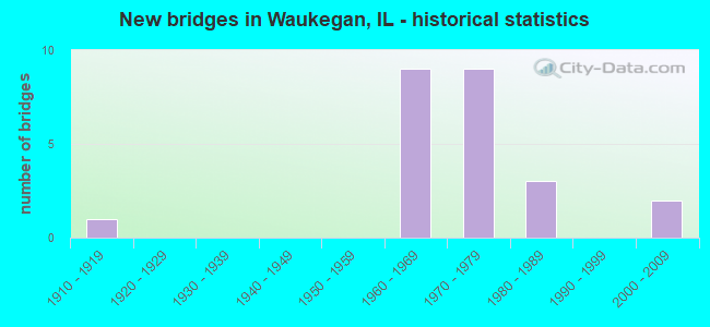
- New bridges - historical statistics
- 11910-1919
- 91960-1969
- 91970-1979
- 31980-1989
- 22000-2009

- Reconstructed bridges - Historical Statistics
- 11970-1979
- 01980-1989
- 01990-1999
- 12000-2009
- 62010-2019


- Bridge Condition - Deck
- 33.3%Good
- 40.0%Satisfactory
- 13.3%Poor
- 13.3%Serious

- Bridge Condition - Superstructure
- 6.7%Very good
- 26.7%Good
- 46.7%Satisfactory
- 6.7%Poor
- 6.7%Serious
- 6.7%Critical

- Bridge Condition - Substructure
- 13.3%Very good
- 60.0%Good
- 6.7%Satisfactory
- 20.0%Fair

- Bridge Condition - Channel
- 50.0%Good
- 50.0%Satisfactory
Find on map >> Show street view
Structure Number: 490048, Location: 0.75 M W OF US 41 (Lat: 42.346806, Lng: -87.906250), Route carried "on" structure: State highway 120, Year Built: 1960, Year Reconstructed: 2018, Status: Open, Structure Length: 4.81m (15.78ft), Average Daily Traffic: 26,100 (year 2021), Truck Traffic: 8%, Average Future Daily Traffic: 15,860 (year 2032), Design Load: HS 20, Features Intersected: RR - CP
Minimum Vertical Clearance: 30+ m (98+ ft), Kilometerpoint: 43.290, Lanes on structure: 2, Base Highway Network: Yes, Owner: State Highway Agency, Approaching Roadway Width: 10.2m (33.5ft), Material/Design: Steel continuous, Design/Construction: Stringer/Multi-beam, Number Of Spans In Main Unit: 3, Length of Maximum Span: 17.4m (57.1ft), Curb-To-Curb Width: 10.2m (33.5ft), Out-to-Out Width: 11.2m (36.7ft)
Condition: Deck: Satisfactory, Superstructure: Satisfactory, Substructure: Good, Operating Rating: 89.1 metric tons, Method Used To Determine Operating Rating: Load Factor (LF) rating reported by rating factor (RF) method using MS18 loading, Inventory Rating: 54.4 metric tons, Method Used To Determine Inventory Rating: Load Factor (LF) rating reported by rating factor (RF) method using MS18 loading, Structural Evaluation: Equal to present minimum criteria, Deck Geometry: Somewhat better than minimum adequacy, Underclear: Somewhat better than minimum adequacy, Approach Roadway Alignment: Equal to present desirable criteria, Length Of Structure Improvement: 5.79m (19.00ft), Designated Inspection Frequency: Every 24 months, Inspection Date: August 2021, Bridge Improvement Cost: $709,000, Roadway Improvement Cost: $71,000, Total Project Cost: $1,064,000, Deck Structure Type: Concrete Cast-file-Place, Wearing Surface/Protective System: Deck Protection: Epoxy Coated Reinforcing
Find on map >> Show street view
Structure Number: 490049, Location: 0.75 M W OF US 41 (Lat: 42.346850, Lng: -87.905658), Route carried "on" structure: State highway 120, Year Built: 1960, Year Reconstructed: 2018, Status: Open, Structure Length: 4.81m (15.78ft), Average Daily Traffic: 26,100 (year 2021), Truck Traffic: 8%, Average Future Daily Traffic: 15,860 (year 2032), Design Load: HS 20, Features Intersected: RR - CP
Minimum Vertical Clearance: 30+ m (98+ ft), Kilometerpoint: 43.242, Lanes on structure: 2, Base Highway Network: Yes, Owner: State Highway Agency, Approaching Roadway Width: 10.2m (33.5ft), Material/Design: Steel continuous, Design/Construction: Stringer/Multi-beam, Number Of Spans In Main Unit: 3, Length of Maximum Span: 17.4m (57.1ft), Curb-To-Curb Width: 10.2m (33.5ft), Out-to-Out Width: 11.2m (36.7ft)
Condition: Deck: Satisfactory, Superstructure: Satisfactory, Substructure: Good, Operating Rating: 89.1 metric tons, Method Used To Determine Operating Rating: Load Factor (LF) rating reported by rating factor (RF) method using MS18 loading, Inventory Rating: 54.4 metric tons, Method Used To Determine Inventory Rating: Load Factor (LF) rating reported by rating factor (RF) method using MS18 loading, Structural Evaluation: Equal to present minimum criteria, Deck Geometry: Somewhat better than minimum adequacy, Underclear: Somewhat better than minimum adequacy, Approach Roadway Alignment: Equal to present desirable criteria, Length Of Structure Improvement: 5.79m (19.00ft), Designated Inspection Frequency: Every 24 months, Inspection Date: August 2021, Bridge Improvement Cost: $709,000, Roadway Improvement Cost: $71,000, Total Project Cost: $1,064,000, Deck Structure Type: Concrete Cast-file-Place, Wearing Surface/Protective System: Deck Protection: Epoxy Coated Reinforcing
Find on map >> Show street view
Structure Number: 490111, Location: 1.4 M E OF I-94 (Lat: 42.348053, Lng: -87.895144), Route carried "on" structure: State highway 43, Year Built: 1973, Status: Open, Structure Length: 8.76m (28.74ft), Average Daily Traffic: 17,500 (year 2021), Truck Traffic: 6%, Average Future Daily Traffic: 18,921 (year 2032), Design Load: HS 20, Features Intersected: IL 120
Minimum Vertical Clearance: 30+ m (98+ ft), Kilometerpoint: 96.333, Lanes on structure: 4, Lanes under structure: 4, Base Highway Network: Yes, Owner: State Highway Agency, Approaching Roadway Width: 25.9m (85.0ft), Skew: 30 degrees, Material/Design: Steel continuous, Design/Construction: Stringer/Multi-beam, Number Of Spans In Main Unit: 2, Number Of Approach Spans: 1, Length of Maximum Span: 42.8m (140.4ft), Curb-To-Curb Width: 20.9m (68.6ft), Out-to-Out Width: 26.8m (87.9ft)
Condition: Deck: Good, Superstructure: Satisfactory, Substructure: Good, Operating Rating: 58.0 metric tons, Method Used To Determine Operating Rating: Load Factor (LF) rating reported by rating factor (RF) method using MS18 loading, Inventory Rating: 34.7 metric tons, Method Used To Determine Inventory Rating: Load Factor (LF) rating reported by rating factor (RF) method using MS18 loading, Structural Evaluation: Equal to present minimum criteria, Deck Geometry: Superior to present desirable criteria, Underclear: Meets minimum limits, Approach Roadway Alignment: Equal to present desirable criteria, Designated Inspection Frequency: Every 24 months, Other Special Inspection Frequency: Every 72 months, Inspection Date: November 2021, Other Special Inspection Date: Febuary 2018, Deck Structure Type: Concrete Cast-file-Place, Wearing Surface/Protective System: Wearing Surface: Latex Concrete
Find on map >> Show street view
Structure Number: 490118, Location: 0.2M E OF SHERIDAN R (Lat: 42.363811, Lng: -87.828869), Route carried "on" structure: Other road , Year Built: 1964, Year Reconstructed: 2008, Status: Open, Structure Length: 2.61m (8.56ft), Average Daily Traffic: 6,950 (year 2019), Truck Traffic: 5%, Average Future Daily Traffic: 11,575 (year 2032), Design Load: HS 20, Features Intersected: IL 137(AMSTUTZ EXPY), Facility Carried by Structure: MATHON DR (GRAND A
Minimum Vertical Clearance: 30+ m (98+ ft), Kilometerpoint: 26.457, Lanes on structure: 4, Lanes under structure: 4, Base Highway Network: Yes, Owner: State Highway Agency, Approaching Roadway Width: 21.3m (69.9ft), Skew: 30 degrees, Material/Design: Steel, Design/Construction: Stringer/Multi-beam, Number Of Spans In Main Unit: 1, Length of Maximum Span: 23.6m (77.4ft), Curb or Sidewalk Widths: Left: 0.0m, Right: 1.2m (3.9ft), Curb-To-Curb Width: 23.2m (76.1ft), Out-to-Out Width: 41.0m (134.5ft)
Condition: Deck: Good, Superstructure: Satisfactory, Substructure: Good, Operating Rating: 58.0 metric tons, Method Used To Determine Operating Rating: Load Factor (LF) rating reported by rating factor (RF) method using MS18 loading, Inventory Rating: 34.7 metric tons, Method Used To Determine Inventory Rating: Load Factor (LF) rating reported by rating factor (RF) method using MS18 loading, Structural Evaluation: Equal to present minimum criteria, Deck Geometry: Superior to present desirable criteria, Underclear: High priority of corrective action, Approach Roadway Alignment: Equal to present desirable criteria, Designated Inspection Frequency: Every 24 months, Inspection Date: March 2021, Deck Structure Type: Concrete Cast-file-Place, Wearing Surface/Protective System: Wearing Surface: Latex Concrete
Find on map >> Show street view
Structure Number: 490125, Location: 1.1 M E OF I-94 (Lat: 42.347175, Lng: -87.901528), Route carried "on" structure: State highway 120, Year Built: 1977, Year Reconstructed: 2018, Status: Open, Structure Length: 6.42m (21.06ft), Average Daily Traffic: 18,200 (year 2021), Truck Traffic: 6%, Average Future Daily Traffic: 10,685 (year 2032), Design Load: HS 20+Mod, Features Intersected: GREENLEAF AVE
Minimum Vertical Clearance: 30+ m (98+ ft), Kilometerpoint: 42.904, Lanes on structure: 3, Lanes under structure: 8, Base Highway Network: Yes, Owner: State Highway Agency, Approaching Roadway Width: 17.1m (56.1ft), Material/Design: Steel continuous, Design/Construction: Stringer/Multi-beam, Number Of Spans In Main Unit: 4, Length of Maximum Span: 20.5m (67.3ft), Curb-To-Curb Width: 15.7m (51.5ft), Out-to-Out Width: 16.7m (54.8ft)
Condition: Deck: Satisfactory, Superstructure: Good, Substructure: Very good, Operating Rating: 82.0 metric tons, Method Used To Determine Operating Rating: Load Factor (LF) rating reported by rating factor (RF) method using MS18 loading, Inventory Rating: 45.4 metric tons, Method Used To Determine Inventory Rating: Load Factor (LF) rating reported by rating factor (RF) method using MS18 loading, Structural Evaluation: Better than present minimum criteria, Deck Geometry: Better than present minimum criteria, Underclear: Equal to present minimum criteria, Approach Roadway Alignment: Equal to present desirable criteria, Designated Inspection Frequency: Every 48 months, Inspection Date: August 2021, Deck Structure Type: Concrete Cast-file-Place, Wearing Surface/Protective System: Deck Protection: Epoxy Coated Reinforcing
Find on map >> Show street view
Structure Number: 490126, Location: 1.1 M E OF I-94 (Lat: 42.347161, Lng: -87.901722), Route carried "on" structure: State highway 120, Year Built: 1977, Year Reconstructed: 2018, Status: Open, Structure Length: 6.42m (21.06ft), Average Daily Traffic: 18,200 (year 2021), Truck Traffic: 6%, Average Future Daily Traffic: 10,685 (year 2032), Design Load: HS 20+Mod, Features Intersected: GREENLEAF AVE
Minimum Vertical Clearance: 30+ m (98+ ft), Kilometerpoint: 42.920, Lanes on structure: 3, Lanes under structure: 8, Base Highway Network: Yes, Owner: State Highway Agency, Approaching Roadway Width: 16.8m (55.1ft), Material/Design: Steel continuous, Design/Construction: Stringer/Multi-beam, Number Of Spans In Main Unit: 4, Length of Maximum Span: 20.5m (67.3ft), Curb-To-Curb Width: 16.8m (55.1ft), Out-to-Out Width: 17.7m (58.1ft)
Condition: Deck: Satisfactory, Superstructure: Good, Substructure: Very good, Operating Rating: 82.0 metric tons, Method Used To Determine Operating Rating: Load Factor (LF) rating reported by rating factor (RF) method using MS18 loading, Inventory Rating: 45.4 metric tons, Method Used To Determine Inventory Rating: Load Factor (LF) rating reported by rating factor (RF) method using MS18 loading, Structural Evaluation: Better than present minimum criteria, Deck Geometry: Superior to present desirable criteria, Underclear: Equal to present minimum criteria, Approach Roadway Alignment: Equal to present desirable criteria, Designated Inspection Frequency: Every 48 months, Inspection Date: August 2021, Deck Structure Type: Concrete Cast-file-Place, Wearing Surface/Protective System: Deck Protection: Epoxy Coated Reinforcing
Find on map >> Show street view
Structure Number: 49013, Location: 0.75 M W OF US 41 (Lat: 42.346442, Lng: -87.906339), Route carried "on" structure: Other road , Year Built: 1977, Year Reconstructed: 2018, Status: Open, Structure Length: 4.92m (16.14ft), Average Daily Traffic: 4,850 (year 2019), Truck Traffic: 5%, Average Future Daily Traffic: 5,009 (year 2032), Design Load: HS 20, Features Intersected: RR - CP, Facility Carried by Structure: IL 120 EB TO GRNLE
Minimum Vertical Clearance: 30+ m (98+ ft), Kilometerpoint: 0.354, Lanes on structure: 2, Base Highway Network: Yes (Inventory Route: 20342040, Subroute: 30), Owner: State Highway Agency, Approaching Roadway Width: 9.9m (32.5ft), Material/Design: Steel continuous, Design/Construction: Stringer/Multi-beam, Number Of Spans In Main Unit: 3, Length of Maximum Span: 18.0m (59.1ft), Curb-To-Curb Width: 9.9m (32.5ft), Out-to-Out Width: 10.8m (35.4ft)
Condition: Deck: Satisfactory, Superstructure: Satisfactory, Substructure: Good, Operating Rating: 89.1 metric tons, Method Used To Determine Operating Rating: Load Factor (LF) rating reported by rating factor (RF) method using MS18 loading, Inventory Rating: 55.7 metric tons, Method Used To Determine Inventory Rating: Load Factor (LF) rating reported by rating factor (RF) method using MS18 loading, Structural Evaluation: Equal to present minimum criteria, Deck Geometry: Meets minimum limits, Underclear: Better than present minimum criteria, Approach Roadway Alignment: Equal to present desirable criteria, Designated Inspection Frequency: Every 24 months, Inspection Date: August 2021, Deck Structure Type: Concrete Cast-file-Place, Wearing Surface/Protective System: Deck Protection: Epoxy Coated Reinforcing
Find on map >> Show street view
Structure Number: 49015, Location: JUST E O SHERIDAN RD (Lat: 42.355111, Lng: -87.829219), Route carried "on" structure: Other road , Year Built: 1966, Status: Open, Structure Length: 4.81m (15.78ft), Average Daily Traffic: 1,000 (year 2019), Truck Traffic: 10%, Average Future Daily Traffic: 1,836 (year 2032), Design Load: HS 20, Features Intersected: C&NW RR& L.F.F-WAY., Facility Carried by Structure: BELVIDERE ST
Minimum Vertical Clearance: 30+ m (98+ ft), Kilometerpoint: 5.295, Lanes on structure: 4, Lanes under structure: 4, Owner: City or Municipal Highway Agency, Approaching Roadway Width: 16.5m (54.1ft), Material/Design: Steel continuous, Design/Construction: Stringer/Multi-beam, Number Of Spans In Main Unit: 2, Length of Maximum Span: 25.0m (82.0ft), Curb or Sidewalk Widths: Left: 1.5m (4.9ft), Right: 1.5m (4.9ft), Curb-To-Curb Width: 16.5m (54.1ft), Out-to-Out Width: 20.1m (65.9ft)
Condition: Deck: Poor, Superstructure: Satisfactory, Substructure: Fair, Operating Rating: 60.3 metric tons, Method Used To Determine Operating Rating: Allowable Stress (AS) rating reported by rating factor (RF) method using MS18 loading, Inventory Rating: 39.5 metric tons, Method Used To Determine Inventory Rating: Allowable Stress (AS) rating reported by rating factor (RF) method using MS18 loading, Structural Evaluation: Somewhat better than minimum adequacy, Deck Geometry: Meets minimum limits, Underclear: High priority of corrective action, Approach Roadway Alignment: Equal to present minimum criteria, Length Of Structure Improvement: 4.82m (15.81ft), Designated Inspection Frequency: Every 24 months, Inspection Date: October 2021, Bridge Improvement Cost: $167,000, Roadway Improvement Cost: $17,000, Total Project Cost: $200,000, Deck Structure Type: Other
Find on map >> Show street view
Structure Number: 490151, Location: 200 FT E SHERIDAN RD (Lat: 42.355083, Lng: -87.828694), Route carried "on" structure: Other road , Year Built: 1966, Status: Open, Structure Length: 25.36m (83.20ft), Average Daily Traffic: 500 (year 2019), Truck Traffic: 10%, Average Future Daily Traffic: 918 (year 2032), Design Load: HS 20, Features Intersected: UNUSED LAND, Facility Carried by Structure: MARKET ST-IL 120RM
Minimum Vertical Clearance: 30+ m (98+ ft), Kilometerpoint: 5.343, Lanes on structure: 2, Owner: City or Municipal Highway Agency, Approaching Roadway Width: 8.5m (27.9ft), Material/Design: Prestressed concrete continuous, Design/Construction: Stringer/Multi-beam, Number Of Spans In Main Unit: 13, Length of Maximum Span: 19.4m (63.6ft), Curb or Sidewalk Widths: Left: 0.6m (2.0ft), Right: 1.5m (4.9ft), Curb-To-Curb Width: 8.5m (27.9ft), Out-to-Out Width: 11.3m (37.1ft)
Condition: Deck: Poor, Superstructure: Poor, Substructure: Fair, Operating Rating: 55.7 metric tons, Method Used To Determine Operating Rating: Load Factor (LF) rating reported by rating factor (RF) method using MS18 loading, Inventory Rating: 33.4 metric tons, Method Used To Determine Inventory Rating: Load Factor (LF) rating reported by rating factor (RF) method using MS18 loading, Structural Evaluation: Meets minimum limits, Deck Geometry: Somewhat better than minimum adequacy, Approach Roadway Alignment: Equal to present minimum criteria, Length Of Structure Improvement: 25.36m (83.20ft), Designated Inspection Frequency: Every 24 months, Inspection Date: October 2021, Bridge Improvement Cost: $1,939,000, Roadway Improvement Cost: $194,000, Total Project Cost: $2,909,000, Deck Structure Type: Other
Find on map >> Show street view
Structure Number: 490159, Location: 0.25 M N OF IL 120 (Lat: 42.357036, Lng: -87.828839), Route carried "on" structure: State highway 137, Year Built: 1988, Status: Open, Structure Length: 2.33m (7.64ft), Average Daily Traffic: 10,700 (year 2021), Truck Traffic: 4%, Average Future Daily Traffic: 8,348 (year 2032), Design Load: HS 20, Features Intersected: WAUKEGAN RIVER
Minimum Vertical Clearance: 30+ m (98+ ft), Kilometerpoint: 22.369, Lanes on structure: 4, Base Highway Network: Yes, Owner: State Highway Agency, Approaching Roadway Width: 21.3m (69.9ft), Skew: 31 degrees, Material/Design: Prestressed concrete, Design/Construction: Stringer/Multi-beam, Number Of Spans In Main Unit: 1, Length of Maximum Span: 22.4m (73.5ft), Curb-To-Curb Width: 21.3m (69.9ft), Out-to-Out Width: 22.9m (75.1ft)
Condition: Deck: Good, Superstructure: Good, Substructure: Good, Channel: Satisfactory, Operating Rating: 77.4 metric tons, Method Used To Determine Operating Rating: Load Factor (LF) rating reported by rating factor (RF) method using MS18 loading, Inventory Rating: 44.1 metric tons, Method Used To Determine Inventory Rating: Load Factor (LF) rating reported by rating factor (RF) method using MS18 loading, Structural Evaluation: Better than present minimum criteria, Deck Geometry: Better than present minimum criteria, Waterway Adequacy: Equal to present desirable criteria, Approach Roadway Alignment: Better than present minimum criteria, Designated Inspection Frequency: Every 48 months, Inspection Date: December 2021, Deck Structure Type: Concrete Cast-file-Place, Wearing Surface/Protective System: Deck Protection: Epoxy Coated Reinforcing
Find on map >> Show street view
Structure Number: 490164, Location: 0.05 M E OF SHERIDAN (Lat: 42.359531, Lng: -87.829381), Route carried "on" structure: City street , Year Built: 1988, Status: Open, Structure Length: 3.02m (9.91ft), Average Daily Traffic: 1,550 (year 2019), Truck Traffic: 10%, Average Future Daily Traffic: 1,123 (year 2032), Design Load: HS 20, Features Intersected: IL 137 (LK FRT FRWY), Facility Carried by Structure: WASHINGTON ST
Minimum Vertical Clearance: 30+ m (98+ ft), Kilometerpoint: 0.032, Lanes on structure: 4, Lanes under structure: 4, Owner: State Highway Agency, Approaching Roadway Width: 16.5m (54.1ft), Material/Design: Steel, Design/Construction: Stringer/Multi-beam, Number Of Spans In Main Unit: 1, Length of Maximum Span: 28.7m (94.2ft), Curb or Sidewalk Widths: Left: 1.5m (4.9ft), Right: 1.5m (4.9ft), Curb-To-Curb Width: 16.5m (54.1ft), Out-to-Out Width: 20.1m (65.9ft)
Condition: Deck: Good, Superstructure: Satisfactory, Substructure: Good, Operating Rating: 70.3 metric tons, Method Used To Determine Operating Rating: Load Factor (LF) rating reported by rating factor (RF) method using MS18 loading, Inventory Rating: 42.4 metric tons, Method Used To Determine Inventory Rating: Load Factor (LF) rating reported by rating factor (RF) method using MS18 loading, Structural Evaluation: Equal to present minimum criteria, Deck Geometry: Meets minimum limits, Underclear: High priority of corrective action, Approach Roadway Alignment: Somewhat better than minimum adequacy, Designated Inspection Frequency: Every 24 months, Inspection Date: March 2021, Deck Structure Type: Concrete Cast-file-Place, Wearing Surface/Protective System: Deck Protection: Epoxy Coated Reinforcing
Find on map >> Show street view
Structure Number: 49205, Location: 0.3 M E SHERIDAN (Lat: 42.363892, Lng: -87.827689), Route carried "on" structure: City street , Year Built: 1968, Year Reconstructed: 2016, Status: Open, Structure Length: 10.43m (34.22ft), Average Daily Traffic: 3,150 (year 2019), Truck Traffic: 10%, Average Future Daily Traffic: 233 (year 2032), Design Load: HS 25 or greater, Features Intersected: UP RR, Facility Carried by Structure: MATHON DR
Minimum Vertical Clearance: 30+ m (98+ ft), Kilometerpoint: 0.080, Lanes on structure: 4, Owner: City or Municipal Highway Agency, Approaching Roadway Width: 19.5m (64.0ft), Skew: 1 degrees, Material/Design: Steel continuous, Design/Construction: Stringer/Multi-beam, Number Of Spans In Main Unit: 4, Length of Maximum Span: 38.8m (127.3ft), Curb or Sidewalk Widths: Left: 1.5m (4.9ft), Right: 1.5m (4.9ft), Curb-To-Curb Width: 17.7m (58.1ft), Out-to-Out Width: 21.6m (70.9ft)
Condition: Deck: Satisfactory, Superstructure: Very good, Substructure: Good, Operating Rating: 42.1 metric tons, Method Used To Determine Operating Rating: Assigned ratings based on Load and Resistance Factor Design (LRFD) reported by rating factor (RF) using HL93 loadings, Inventory Rating: 32.4 metric tons, Method Used To Determine Inventory Rating: Assigned ratings based on Load and Resistance Factor Design (LRFD) reported by rating factor (RF) using HL93 loadings, Structural Evaluation: Better than present minimum criteria, Deck Geometry: Somewhat better than minimum adequacy, Underclear: Better than present minimum criteria, Approach Roadway Alignment: Equal to present desirable criteria, Length Of Structure Improvement: 10.42m (34.19ft), Designated Inspection Frequency: Every 24 months, Inspection Date: July 2020, Bridge Improvement Cost: $1,265,000, Roadway Improvement Cost: $127,000, Total Project Cost: $1,898,000, Deck Structure Type: Concrete Cast-file-Place, Wearing Surface/Protective System: Deck Protection: Epoxy Coated Reinforcing
Find on map >> Show street view
Structure Number: 498, Location: ON GEN ST S OF WATER (Lat: 42.357044, Lng: -87.831386), Route carried "on" structure: Other road , Year Built: 1913, Year Reconstructed: 1984, Status: Posted for load, Structure Length: 11.28m (37.01ft), Average Daily Traffic: 2,350 (year 2019), Truck Traffic: 8%, Average Future Daily Traffic: 2,783 (year 2032), Features Intersected: WAUKEGAN RIVER, Facility Carried by Structure: GENESEE ST
Minimum Vertical Clearance: 30+ m (98+ ft), Kilometerpoint: 0.724, Lanes on structure: 4, Owner: City or Municipal Highway Agency, Approaching Roadway Width: 16.2m (53.1ft), Material/Design: Concrete, Number Of Spans In Main Unit: 3, Number Of Approach Spans: 2, Length of Maximum Span: 33.5m (109.9ft), Curb or Sidewalk Widths: Left: 4.0m (13.1ft), Right: 4.0m (13.1ft), Curb-To-Curb Width: 13.4m (44.0ft), Out-to-Out Width: 19.5m (64.0ft)
Condition: Deck: Serious, Superstructure: Serious, Substructure: Satisfactory, Channel: Good, Operating Rating: 21.1 metric tons, Method Used To Determine Operating Rating: Field evaluation and documented engineering judgment, Inventory Rating: 12.6 metric tons, Method Used To Determine Inventory Rating: Field evaluation and documented engineering judgment, Structural Evaluation: High priority of corrective action, Deck Geometry: High priority of replacement, Waterway Adequacy: Superior to present desirable criteria, Approach Roadway Alignment: Equal to present desirable criteria, Bridge Posting: Required (Relationship of Operating Rating to Maximum Legal Load: > 39.9% below), Length Of Structure Improvement: 11.86m (38.91ft), Designated Inspection Frequency: Every 24 months, Other Special Inspection Frequency: Every 12 months, Inspection Date: October 2021, Other Special Inspection Date: October 2021, Bridge Improvement Cost: $2,501,000, Roadway Improvement Cost: $250,000, Total Project Cost: $3,752,000, Deck Structure Type: Concrete Cast-file-Place
Find on map >> Show street view
Structure Number: 49993, Location: I94 .7M SE ILL 120 (Lat: 42.335806, Lng: -87.914586), Route carried "on" structure: Other road , Year Built: 2009, Status: Open, Structure Length: 10.84m (35.56ft), Average Daily Traffic: 9,600 (year 2019), Truck Traffic: 2%, Average Future Daily Traffic: 14,580 (year 2032), Design Load: HS 20, Features Intersected: INTERSTATE 94, Facility Carried by Structure: O'PLAINE ROAD
Minimum Vertical Clearance: 30+ m (98+ ft), Kilometerpoint: 3.830, Lanes on structure: 2, Lanes under structure: 6, Base Highway Network: Yes, Owner: County Highway Agency, Approaching Roadway Width: 11.0m (36.1ft), Material/Design: Steel continuous, Design/Construction: Stringer/Multi-beam, Number Of Spans In Main Unit: 2, Length of Maximum Span: 52.3m (171.6ft), Curb-To-Curb Width: 11.0m (36.1ft), Out-to-Out Width: 11.9m (39.0ft)
Condition: Deck: Good, Superstructure: Good, Substructure: Good, Operating Rating: 97.2 metric tons, Method Used To Determine Operating Rating: Load Factor (LF) rating reported by rating factor (RF) method using MS18 loading, Inventory Rating: 63.8 metric tons, Method Used To Determine Inventory Rating: Load Factor (LF) rating reported by rating factor (RF) method using MS18 loading, Structural Evaluation: Better than present minimum criteria, Deck Geometry: Meets minimum limits, Underclear: High priority of corrective action, Approach Roadway Alignment: Equal to present desirable criteria, Designated Inspection Frequency: Every 24 months, Inspection Date: May 2020, Deck Structure Type: Concrete Cast-file-Place, Wearing Surface/Protective System: Deck Protection: Epoxy Coated Reinforcing
Find on map >> Show street view
Structure Number: 499952, Location: 0.5 M E SHERIDAN RD (Lat: 42.384689, Lng: -87.824439), Route carried "on" structure: Other road , Year Built: 1972, Status: Temporarily open, Structure Length: 4.88m (16.01ft), Average Daily Traffic: 600 (year 2019), Truck Traffic: 18%, Average Future Daily Traffic: 870 (year 2032), Design Load: H 15, Features Intersected: UPRR, Facility Carried by Structure: GREENWOOD AVE
Minimum Vertical Clearance: 30+ m (98+ ft), Kilometerpoint: 0.113, Lanes on structure: 4, Owner: City or Municipal Highway Agency, Approaching Roadway Width: 20.7m (67.9ft), Skew: 30 degrees, Material/Design: Steel, Design/Construction: Stringer/Multi-beam, Number Of Spans In Main Unit: 3, Number Of Approach Spans: 2, Length of Maximum Span: 21.3m (69.9ft), Curb or Sidewalk Widths: Left: 1.5m (4.9ft), Right: 1.5m (4.9ft), Curb-To-Curb Width: 20.7m (67.9ft), Out-to-Out Width: 24.4m (80.1ft)
Condition: Deck: Serious, Superstructure: Critical, Substructure: Fair, Structural Evaluation: High priority of replacement, Deck Geometry: Superior to present desirable criteria, Underclear: Superior to present desirable criteria, Approach Roadway Alignment: Equal to present desirable criteria, Designated Inspection Frequency: Every 24 months, Other Special Inspection Frequency: Every 3 months, Inspection Date: October 2021, Other Special Inspection Date: January 2022, Deck Structure Type: Other
Find on map >> Show street view
Structure Number: 490111, Location: 1.4 M E OF I-94 (Lat: 42.347669, Lng: -87.895164), Route carried "under" structure: State highway 120, Year Built: 1973, Structure Length: 0. m, Average Daily Traffic: 18,200 (year 2021), Truck Traffic: 6%, Features Intersected: IL 120, Facility Carried by Structure: IL 43 (TELEGRAPH)
Minimum Vertical Clearance: 5.11m (16.77ft), Kilometerpoint: 42.373, Lanes on structure: 4, Lanes under structure: 4, Material/Design: Steel continuous, Design/Construction: Stringer/Multi-beam, Length of Maximum Span: 42.8m (140.4ft)
Find on map >> Show street view
Structure Number: 490118, Location: 0.2M E OF SHERIDAN R (Lat: 42.363817, Lng: -87.828811), Route carried "under" structure: State highway 137, Year Built: 1964, Structure Length: 0. m, Average Daily Traffic: 10,700 (year 2021), Truck Traffic: 4%, Features Intersected: IL 137(AMSTUTZ EXPY), Facility Carried by Structure: MATHON DR (GRAND A
Minimum Vertical Clearance: 4.47m (14.67ft), Kilometerpoint: 23.110, Lanes on structure: 4, Lanes under structure: 4, Material/Design: Steel, Design/Construction: Stringer/Multi-beam, Length of Maximum Span: 23.6m (77.4ft)
Find on map >> Show street view
Structure Number: 490125, Location: 1.1 M E OF I-94 (Lat: 42.347142, Lng: -87.902006), Route carried "under" structure: Other road , Year Built: 1977, Structure Length: 0. m, Average Daily Traffic: 13,600 (year 2019), Truck Traffic: 2%, Features Intersected: GREENLEAF AVE, Facility Carried by Structure: IL 120 WB
Minimum Vertical Clearance: 4.93m (16.17ft), Kilometerpoint: 1.835, Lanes on structure: 3, Lanes under structure: 8, Material/Design: Steel continuous, Design/Construction: Stringer/Multi-beam, Length of Maximum Span: 20.5m (67.3ft)
Find on map >> Show street view
Structure Number: 490126, Location: 1.1 M E OF I-94 (Lat: 42.346978, Lng: -87.901986), Route carried "under" structure: Other road , Year Built: 1977, Structure Length: 0. m, Average Daily Traffic: 13,600 (year 2019), Truck Traffic: 2%, Features Intersected: GREENLEAF AVE, Facility Carried by Structure: IL 120 EB
Minimum Vertical Clearance: 4.75m (15.58ft), Kilometerpoint: 1.867, Lanes on structure: 3, Lanes under structure: 8, Material/Design: Steel continuous, Design/Construction: Stringer/Multi-beam, Length of Maximum Span: 20.5m (67.3ft)
Find on map >> Show street view
Structure Number: 49015, Location: JUST E O SHERIDAN RD (Lat: 42.355100, Lng: -87.829039), Route carried "under" structure: State highway 137, Year Built: 1966, Structure Length: 0. m, Average Daily Traffic: 14,400 (year 2021), Truck Traffic: 2%, Features Intersected: C&NW RR& L.F.F-WAY., Facility Carried by Structure: BELVIDERE ST
Minimum Vertical Clearance: 4.50m (14.76ft), Kilometerpoint: 22.128, Lanes on structure: 4, Lanes under structure: 4, Material/Design: Steel continuous, Design/Construction: Stringer/Multi-beam, Length of Maximum Span: 25.0m (82.0ft)
Find on map >> Show street view
Structure Number: 490164, Location: 0.05 M E OF SHERIDAN (Lat: 42.359136, Lng: -87.828839), Route carried "under" structure: State highway 137, Year Built: 1988, Structure Length: 0. m, Average Daily Traffic: 10,700 (year 2021), Truck Traffic: 4%, Features Intersected: IL 137 (LK FRT FRWY), Facility Carried by Structure: WASHINGTON ST
Minimum Vertical Clearance: 5.41m (17.75ft), Kilometerpoint: 22.627, Lanes on structure: 4, Lanes under structure: 4, Material/Design: Steel, Design/Construction: Stringer/Multi-beam, Length of Maximum Span: 28.7m (94.2ft)
Find on map >> Show street view
Structure Number: 493052, Location: .6 MI E ILL 43 (Lat: 42.334308, Lng: -87.884911), Route carried "under" structure: US 41, Year Built: 1979, Structure Length: 0. m, Average Daily Traffic: 30,800 (year 2021), Truck Traffic: 9%, Features Intersected: US RTE 41, Facility Carried by Structure: PULASKI DR 14TH ST
Minimum Vertical Clearance: 7.52m (24.67ft), Kilometerpoint: 82.879, Lanes on structure: 4, Lanes under structure: 4, Material/Design: Steel continuous, Design/Construction: Stringer/Multi-beam, Length of Maximum Span: 30.1m (98.8ft)
Find on map >> Show street view
Structure Number: 496048, Location: .25 E OF DELANY RD (Lat: 42.392636, Lng: -87.899064), Route carried "under" structure: Other road , Year Built: 1969, Structure Length: 0. m, Average Daily Traffic: 17,600 (year 2019), Truck Traffic: 6%, Features Intersected: SUNSET AVE, Facility Carried by Structure: C&NW RR
Minimum Vertical Clearance: 4.65m (15.26ft), Kilometerpoint: 0.435, Lanes under structure: 4, Material/Design: Steel, Design/Construction: Stringer/Multi-beam, Length of Maximum Span: 13.4m (44.0ft)
Find on map >> Show street view
Structure Number: 496052, Location: .2M N of Greenwood (Lat: 42.387703, Lng: -87.833008), Route carried "under" structure: State highway 137, Structure Length: 0. m, Average Daily Traffic: 18,800 (year 2019), Truck Traffic: 3%, Features Intersected: Sheridan Rd, Facility Carried by Structure: pedestrian crossin
Minimum Vertical Clearance: 4.78m (15.68ft), Kilometerpoint: 26.232, Lanes under structure: 4, Material/Design: Steel, Length of Maximum Span: 20.1m (65.9ft)
Find on map >> Show street view
Structure Number: 49993, Location: I94 .7M SE ILL 120 (Lat: 42.335806, Lng: -87.914586), Route carried "under" structure: Interstate 94, Year Built: 2009, Structure Length: 0. m, Average Daily Traffic: 96,900 (year 2021), Truck Traffic: 8%, Features Intersected: INTERSTATE 94, Facility Carried by Structure: O'PLAINE ROAD
Minimum Vertical Clearance: 30+ m (98+ ft), Kilometerpoint: 19.376, Lanes on structure: 2, Lanes under structure: 6, Material/Design: Steel continuous, Design/Construction: Stringer/Multi-beam, Length of Maximum Span: 52.3m (171.6ft)