Bridge Statistics for Tyrone, Georgia (GA)
Condition, Traffic, Stress, Structural Evaluation, Project Costs
- National Bridge Inventory (NBI) Statistics
- 13Number of bridges
- 125ft / 37.8mTotal length
- $7,136,000Total costs
- 87,548Total average daily traffic
- 3,974Total average daily truck traffic
- National Bridge Inventory (NBI) Registered Bridges for Tyrone
- No street view available for this location
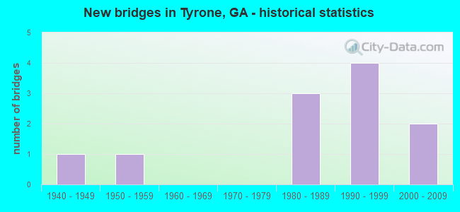
- New bridges - historical statistics
- 11940-1949
- 11950-1959
- 31980-1989
- 41990-1999
- 22000-2009


- Bridge Condition - Deck
- 60.0%Good
- 20.0%Satisfactory
- 20.0%Fair

- Bridge Condition - Superstructure
- 80.0%Good
- 20.0%Poor

- Bridge Condition - Substructure
- 80.0%Good
- 20.0%Poor

- Bridge Condition - Channel
- 71.4%Very good
- 14.3%Good
- 14.3%Satisfactory

- Bridge Condition - Culverts
- 66.7%Good
- 33.3%Fair
Find on map >> Show street view
Structure Number: 770065, Location: 3.5 MI SE OF PALMETTO (Lat: 33.492419, Lng: -84.613408), Route carried "on" structure: County highway 846, Year Built: 1987, Status: Open, Structure Length: 1.68m (5.51ft), Average Daily Traffic: 6,490 (year 2012), Truck Traffic: 1%, Average Future Daily Traffic: 9,735 (year 2032), Design Load: HS 20+Mod, Features Intersected: LINE CREEK, Facility Carried by Structure: COLLINSWORTH ROAD
Minimum Vertical Clearance: 30+ m (98+ ft), Kilometerpoint: 4.828, Lanes on structure: 2, Base Highway Network: Yes, Owner: County Highway Agency, Approaching Roadway Width: 7.3m (24.0ft), Material/Design: Concrete, Design/Construction: Culvert, Number Of Spans In Main Unit: 5, Length of Maximum Span: 3.0m (9.8ft)
Condition: Channel: Very good, Culverts: Good, Operating Rating: 55.3 metric tons, Method Used To Determine Operating Rating: Field evaluation and documented engineering judgment, Inventory Rating: 32.6 metric tons, Method Used To Determine Inventory Rating: Field evaluation and documented engineering judgment, Structural Evaluation: Better than present minimum criteria, Waterway Adequacy: Equal to present desirable criteria, Approach Roadway Alignment: Equal to present desirable criteria, Designated Inspection Frequency: Every 24 months, Inspection Date: November 2020, Bridge Improvement Cost: $215,000, Roadway Improvement Cost: $21,000, Total Project Cost: $322,000
Find on map >> Show street view
Structure Number: 775079, Location: AT FAYETTE CO LINE (Lat: 33.463028, Lng: -84.625308), Route carried "on" structure: County highway 462, Year Built: 1959, Status: Open, Structure Length: 3.11m (10.20ft), Average Daily Traffic: 1,930 (year 2012), Truck Traffic: 1%, Average Future Daily Traffic: 2,895 (year 2032), Design Load: H 15, Features Intersected: LINE CREEK, Facility Carried by Structure: PALMETTO TYRONE RD
Minimum Vertical Clearance: 30+ m (98+ ft), Kilometerpoint: 1.609, Lanes on structure: 2, Base Highway Network: Yes, Owner: County Highway Agency, Approaching Roadway Width: 6.1m (20.0ft), Skew: 3 degrees, Material/Design: Concrete, Design/Construction: Tee Beam, Number Of Spans In Main Unit: 3, Length of Maximum Span: 10.4m (34.1ft), Curb or Sidewalk Widths: Left: 0.6m (2.0ft), Right: 0.6m (2.0ft), Curb-To-Curb Width: 7.3m (24.0ft), Out-to-Out Width: 9.2m (30.2ft)
Condition: Deck: Satisfactory, Superstructure: Good, Substructure: Good, Channel: Satisfactory, Operating Rating: 32.6 metric tons, Method Used To Determine Operating Rating: Load Factor (LF), Inventory Rating: 19.0 metric tons, Method Used To Determine Inventory Rating: Load Factor (LF), Structural Evaluation: Somewhat better than minimum adequacy, Deck Geometry: Meets minimum limits, Waterway Adequacy: Equal to present desirable criteria, Approach Roadway Alignment: Better than present minimum criteria, Designated Inspection Frequency: Every 24 months, Underwater Inspection Frequency: Every 60 months, Inspection Date: October 2020, Underwater Inspection Date: March 2020, Bridge Improvement Cost: $399,000, Roadway Improvement Cost: $40,000, Total Project Cost: $598,000, Deck Structure Type: Concrete Cast-file-Place
Find on map >> Show street view
Structure Number: 775105, Location: 4 MI SE OF PALMETTO (Lat: 33.452419, Lng: -84.641719), Route carried "on" structure: County highway 33, Year Built: 1995, Status: Open, Structure Length: 1.37m (4.49ft), Average Daily Traffic: 1,010 (year 2012), Truck Traffic: 1%, Average Future Daily Traffic: 1,515 (year 2032), Design Load: HS 20+Mod, Features Intersected: LITTLE CREEK, Facility Carried by Structure: MAJOR ROAD
Minimum Vertical Clearance: 30+ m (98+ ft), Kilometerpoint: 1.609, Lanes on structure: 2, Base Highway Network: Yes, Owner: County Highway Agency, Approaching Roadway Width: 6.7m (22.0ft), Skew: 4 degrees, Material/Design: Concrete, Design/Construction: Culvert, Number Of Spans In Main Unit: 3, Length of Maximum Span: 4.3m (14.1ft)
Condition: Channel: Good, Culverts: Good, Operating Rating: 55.3 metric tons, Method Used To Determine Operating Rating: Field evaluation and documented engineering judgment, Inventory Rating: 32.6 metric tons, Method Used To Determine Inventory Rating: Field evaluation and documented engineering judgment, Structural Evaluation: Better than present minimum criteria, Waterway Adequacy: Equal to present desirable criteria, Approach Roadway Alignment: Equal to present desirable criteria, Designated Inspection Frequency: Every 24 months, Inspection Date: November 2020, Bridge Improvement Cost: $176,000, Roadway Improvement Cost: $18,000, Total Project Cost: $264,000
Find on map >> Show street view
Structure Number: 775149, Location: 9 MI NE OF NEWNAN (Lat: 33.445958, Lng: -84.670278), Route carried "on" structure: County highway 32, Year Built: 2006, Status: Open, Structure Length: 1.16m (3.81ft), Average Daily Traffic: 5,480 (year 2012), Truck Traffic: 1%, Average Future Daily Traffic: 8,220 (year 2032), Design Load: HS 20+Mod, Features Intersected: SHOAL CREEK, Facility Carried by Structure: RAYMOND HILL ROAD
Minimum Vertical Clearance: 30+ m (98+ ft), Kilometerpoint: 1.609, Lanes on structure: 2, Base Highway Network: Yes, Owner: County Highway Agency, Approaching Roadway Width: 7.3m (24.0ft), Material/Design: Concrete, Design/Construction: Culvert, Number Of Spans In Main Unit: 4, Length of Maximum Span: 2.4m (7.9ft)
Condition: Channel: Very good, Culverts: Good, Operating Rating: 55.3 metric tons, Method Used To Determine Operating Rating: Field evaluation and documented engineering judgment, Inventory Rating: 32.6 metric tons, Method Used To Determine Inventory Rating: Field evaluation and documented engineering judgment, Structural Evaluation: Better than present minimum criteria, Waterway Adequacy: Equal to present desirable criteria, Approach Roadway Alignment: Superior to present desirable criteria, Designated Inspection Frequency: Every 24 months, Inspection Date: November 2020, Bridge Improvement Cost: $148,000, Roadway Improvement Cost: $15,000, Total Project Cost: $223,000
Find on map >> Show street view
Structure Number: 775152, Location: 4 MI NE OF PEACHTREE CITY (Lat: 33.439547, Lng: -84.635578), Route carried "on" structure: County highway 1466, Year Built: 2000, Status: Open, Structure Length: 1.34m (4.40ft), Average Daily Traffic: 1,930 (year 2012), Truck Traffic: 1%, Average Future Daily Traffic: 2,895 (year 2032), Design Load: HS 20+Mod, Features Intersected: LITTLE CREEK, Facility Carried by Structure: EVAN CONNECTOR
Minimum Vertical Clearance: 30+ m (98+ ft), Kilometerpoint: 0.000, Lanes on structure: 2, Base Highway Network: Yes, Owner: County Highway Agency, Approaching Roadway Width: 7.3m (24.0ft), Material/Design: Concrete, Design/Construction: Culvert, Number Of Spans In Main Unit: 4, Length of Maximum Span: 3.0m (9.8ft)
Condition: Channel: Very good, Culverts: Good, Operating Rating: 32.6 metric tons, Method Used To Determine Operating Rating: Field evaluation and documented engineering judgment, Inventory Rating: 18.1 metric tons, Method Used To Determine Inventory Rating: Field evaluation and documented engineering judgment, Structural Evaluation: Somewhat better than minimum adequacy, Waterway Adequacy: Equal to present desirable criteria, Approach Roadway Alignment: Superior to present desirable criteria, Designated Inspection Frequency: Every 24 months, Inspection Date: November 2020, Bridge Improvement Cost: $172,000, Roadway Improvement Cost: $17,000, Total Project Cost: $258,000
Find on map >> Show street view
Structure Number: 113003, Location: TYRONE CITY LIMITS (Lat: 33.482858, Lng: -84.585439), Route carried "on" structure: State highway 74, Year Built: 1988, Status: Open, Structure Length: 9.39m (30.81ft), Average Daily Traffic: 25,860 (year 2011), Truck Traffic: 7%, Average Future Daily Traffic: 38,790 (year 2031), Design Load: HS 20+Mod, Features Intersected: CR 480- CSX RAILROAD
Minimum Vertical Clearance: 30+ m (98+ ft), Kilometerpoint: 4.828, Lanes on structure: 2, Lanes under structure: 2, Base Highway Network: Yes, Owner: State Highway Agency, Approaching Roadway Width: 9.4m (30.8ft), Skew: 15 degrees, Material/Design: Prestressed concrete, Design/Construction: Stringer/Multi-beam, Number Of Spans In Main Unit: 4, Length of Maximum Span: 30.2m (99.1ft), Curb-To-Curb Width: 11.6m (38.1ft), Out-to-Out Width: 12.6m (41.3ft)
Condition: Deck: Good, Superstructure: Good, Substructure: Good, Operating Rating: 48.0 metric tons, Method Used To Determine Operating Rating: Load Factor (LF), Inventory Rating: 28.1 metric tons, Method Used To Determine Inventory Rating: Load Factor (LF), Structural Evaluation: Better than present minimum criteria, Deck Geometry: Better than present minimum criteria, Underclear: Equal to present minimum criteria, Approach Roadway Alignment: Equal to present desirable criteria, Designated Inspection Frequency: Every 24 months, Inspection Date: June 2020, Bridge Improvement Cost: $1,203,000, Roadway Improvement Cost: $120,000, Total Project Cost: $1,805,000, Deck Structure Type: Concrete Cast-file-Place
Find on map >> Show street view
Structure Number: 1130031, Location: TYRONE CITY LIMITS (Lat: 33.482658, Lng: -84.585689), Route carried "on" structure: State highway 74, Year Built: 1988, Status: Open, Structure Length: 9.39m (30.81ft), Average Daily Traffic: 25,860 (year 2011), Truck Traffic: 7%, Average Future Daily Traffic: 38,790 (year 2031), Design Load: HS 20+Mod, Features Intersected: CR 480- CSX RAILROAD
Minimum Vertical Clearance: 30+ m (98+ ft), Kilometerpoint: 4.828, Lanes on structure: 2, Lanes under structure: 2, Base Highway Network: Yes, Owner: State Highway Agency, Approaching Roadway Width: 9.4m (30.8ft), Skew: 15 degrees, Material/Design: Prestressed concrete, Design/Construction: Stringer/Multi-beam, Number Of Spans In Main Unit: 4, Length of Maximum Span: 30.2m (99.1ft), Curb-To-Curb Width: 11.6m (38.1ft), Out-to-Out Width: 12.6m (41.3ft)
Condition: Deck: Good, Superstructure: Good, Substructure: Good, Operating Rating: 45.3 metric tons, Method Used To Determine Operating Rating: Load Factor (LF), Inventory Rating: 24.4 metric tons, Method Used To Determine Inventory Rating: Load Factor (LF), Structural Evaluation: Equal to present minimum criteria, Deck Geometry: Better than present minimum criteria, Underclear: Equal to present minimum criteria, Approach Roadway Alignment: Equal to present desirable criteria, Designated Inspection Frequency: Every 24 months, Inspection Date: June 2020, Bridge Improvement Cost: $1,203,000, Roadway Improvement Cost: $120,000, Total Project Cost: $1,805,000, Deck Structure Type: Concrete Cast-file-Place
Find on map >> Show street view
Structure Number: 1135005, Location: 3 MI NE OF TYRONE (Lat: 33.519069, Lng: -84.549419), Route carried "on" structure: County highway 61, Year Built: 1940, Status: Posted for load, Structure Length: 2.41m (7.91ft), Average Daily Traffic: 2,202 (year 2011), Truck Traffic: 1%, Average Future Daily Traffic: 3,303 (year 2031), Features Intersected: CSX RAILROAD (639500S), Facility Carried by Structure: COASTLINE ROAD
Minimum Vertical Clearance: 30+ m (98+ ft), Kilometerpoint: 0.000, Lanes on structure: 1, Base Highway Network: Yes, Owner: Railroad, Approaching Roadway Width: 4.9m (16.1ft), Material/Design: Wood or Timber, Design/Construction: Stringer/Multi-beam, Number Of Spans In Main Unit: 5, Length of Maximum Span: 6.4m (21.0ft), Curb or Sidewalk Widths: Left: 0.2m (0.7ft), Right: 0.2m (0.7ft), Curb-To-Curb Width: 4.4m (14.4ft), Out-to-Out Width: 4.8m (15.7ft)
Condition: Deck: Fair, Superstructure: Poor, Substructure: Poor, Operating Rating: 9.9 metric tons, Method Used To Determine Operating Rating: Load Factor (LF), Inventory Rating: 7.2 metric tons, Method Used To Determine Inventory Rating: Load Factor (LF), Structural Evaluation: High priority of replacement, Deck Geometry: High priority of replacement, Underclear: Meets minimum limits, Approach Roadway Alignment: Somewhat better than minimum adequacy, Bridge Posting: Required (Relationship of Operating Rating to Maximum Legal Load: > 39.9% below), Length Of Structure Improvement: 42.61m (139.80ft), Designated Inspection Frequency: Every 24 months, Other Special Inspection Frequency: Every 24 months, Inspection Date: June 2020, Other Special Inspection Date: June 2021, Bridge Improvement Cost: $224,000, Roadway Improvement Cost: $22,000, Total Project Cost: $337,000, Deck Structure Type: Wood or Timber, Wearing Surface/Protective System: Wearing Surface: Wood or Timber
Find on map >> Show street view
Structure Number: 1135008, Location: 2.5 MI NE OF TYRONE (Lat: 33.495150, Lng: -84.564419), Route carried "on" structure: County highway 75, Year Built: 1990, Status: Open, Structure Length: 5.49m (18.01ft), Average Daily Traffic: 2,202 (year 2011), Truck Traffic: 1%, Average Future Daily Traffic: 3,303 (year 2031), Design Load: HS 20, Features Intersected: CSX RAILROAD (639497L), Facility Carried by Structure: JENKINS ROAD
Minimum Vertical Clearance: 30+ m (98+ ft), Kilometerpoint: 1.609, Lanes on structure: 2, Base Highway Network: Yes, Owner: County Highway Agency, Approaching Roadway Width: 7.3m (24.0ft), Skew: 3 degrees, Material/Design: Prestressed concrete, Design/Construction: Stringer/Multi-beam, Number Of Spans In Main Unit: 3, Length of Maximum Span: 18.3m (60.0ft), Curb-To-Curb Width: 11.6m (38.1ft), Out-to-Out Width: 12.6m (41.3ft)
Condition: Deck: Good, Superstructure: Good, Substructure: Good, Operating Rating: 70.7 metric tons, Method Used To Determine Operating Rating: Load Factor (LF), Inventory Rating: 39.0 metric tons, Method Used To Determine Inventory Rating: Load Factor (LF), Structural Evaluation: Better than present minimum criteria, Deck Geometry: Somewhat better than minimum adequacy, Underclear: Equal to present minimum criteria, Approach Roadway Alignment: Equal to present desirable criteria, Designated Inspection Frequency: Every 24 months, Inspection Date: May 2020, Bridge Improvement Cost: $703,000, Roadway Improvement Cost: $70,000, Total Project Cost: $1,055,000, Deck Structure Type: Concrete Cast-file-Place
Find on map >> Show street view
Structure Number: 1135041, Location: 1 MI N OF TYRONE (Lat: 33.498408, Lng: -84.601397), Route carried "on" structure: County highway 70, Year Built: 1990, Status: Open, Structure Length: 0.85m (2.79ft), Average Daily Traffic: 2,202 (year 2011), Truck Traffic: 1%, Average Future Daily Traffic: 3,303 (year 2031), Design Load: H 15, Features Intersected: TRICKUM CREEK, Facility Carried by Structure: TRICKUM CREEK RD
Minimum Vertical Clearance: 30+ m (98+ ft), Kilometerpoint: 0.000, Lanes on structure: 2, Base Highway Network: Yes, Owner: County Highway Agency, Approaching Roadway Width: 4.9m (16.1ft), Material/Design: Steel, Design/Construction: Culvert, Number Of Spans In Main Unit: 3, Length of Maximum Span: 2.1m (6.9ft)
Condition: Channel: Very good, Culverts: Fair, Structural Evaluation: Somewhat better than minimum adequacy, Waterway Adequacy: Equal to present desirable criteria, Approach Roadway Alignment: Equal to present minimum criteria, Designated Inspection Frequency: Every 24 months, Inspection Date: May 2020, Bridge Improvement Cost: $109,000, Roadway Improvement Cost: $11,000, Total Project Cost: $164,000
Find on map >> Show street view
Structure Number: 1135044, Location: 4 MI NE OF TYRONE (Lat: 33.514478, Lng: -84.554289), Route carried "on" structure: County highway 61, Year Built: 1991, Status: Open, Structure Length: 1.58m (5.18ft), Average Daily Traffic: 2,202 (year 2011), Truck Traffic: 1%, Average Future Daily Traffic: 3,303 (year 2031), Design Load: H 15, Features Intersected: WHITEWATER CREEK, Facility Carried by Structure: COASTLINE ROAD
Minimum Vertical Clearance: 30+ m (98+ ft), Kilometerpoint: 1.609, Lanes on structure: 2, Base Highway Network: Yes, Owner: County Highway Agency, Approaching Roadway Width: 7.3m (24.0ft), Material/Design: Steel, Design/Construction: Culvert, Number Of Spans In Main Unit: 5, Length of Maximum Span: 2.4m (7.9ft)
Condition: Channel: Very good, Culverts: Fair, Operating Rating: 41.7 metric tons, Method Used To Determine Operating Rating: Field evaluation and documented engineering judgment, Inventory Rating: 24.4 metric tons, Method Used To Determine Inventory Rating: Field evaluation and documented engineering judgment, Structural Evaluation: Somewhat better than minimum adequacy, Waterway Adequacy: Equal to present desirable criteria, Approach Roadway Alignment: Equal to present desirable criteria, Designated Inspection Frequency: Every 24 months, Inspection Date: May 2020, Bridge Improvement Cost: $203,000, Roadway Improvement Cost: $20,000, Total Project Cost: $305,000
Find on map >> Show street view
Structure Number: 113003, Location: TYRONE CITY LIMITS (Lat: 33.482858, Lng: -84.585439), Route carried "under" structure: County highway 480, Structure Length: 0. m, Average Daily Traffic: 5,090 (year 1999), Truck Traffic: 1%, Features Intersected: SR 74 WBL, Facility Carried by Structure: SR 74 WBL
Minimum Vertical Clearance: 6.70m (21.98ft), Kilometerpoint: 8.047, Lanes on structure: 2, Length of Maximum Span: 0.0m
Find on map >> Show street view
Structure Number: 1130031, Location: TYRONE CITY LIMITS (Lat: 33.482658, Lng: -84.585689), Route carried "under" structure: County highway 480, Structure Length: 0. m, Average Daily Traffic: 5,090 (year 1999), Truck Traffic: 1%, Features Intersected: SR 74 EBL, Facility Carried by Structure: SR 74 EBL
Minimum Vertical Clearance: 7.18m (23.56ft), Kilometerpoint: 8.047, Lanes on structure: 2, Length of Maximum Span: 0.0m