Bridge Statistics for Timberwood Park, Texas (TX)
Condition, Traffic, Stress, Structural Evaluation, Project Costs
- National Bridge Inventory (NBI) Statistics
- 25Number of bridges
- 295ft / 89.7mTotal length
- $19,000Total costs
- 181,083Total average daily traffic
- 5,462Total average daily truck traffic
- 199,040Total future (year 2027) average daily traffic
- National Bridge Inventory (NBI) Registered Bridges for Timberwood Park
- No street view available for this location
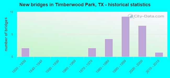
- New bridges - historical statistics
- 21930-1939
- 21970-1979
- 41980-1989
- 91990-1999
- 72000-2009
- 12010-2019

- Reconstructed bridges - Historical Statistics
- 11950-1959
- 01960-1969
- 11970-1979
- 01980-1989
- 01990-1999
- 02000-2009
- 42010-2019


- Bridge Condition - Deck
- 66.7%Good
- 33.3%Satisfactory

- Bridge Condition - Channel
- 8.0%Very good
- 76.0%Good
- 16.0%Satisfactory

- Bridge Condition - Culverts
- 72.7%Good
- 27.3%Satisfactory
Find on map >> Show street view
Structure Number: 150150025304007, Location: 100 FT N OF BULVERDE RD (Lat: 29.693817, Lng: -98.452133), Route carried "on" structure: US 281, Year Built: 1934, Year Reconstructed: 1975, Status: Open, Structure Length: 0.76m (2.49ft), Average Daily Traffic: 55,399 (year 2019), Truck Traffic: 3%, Average Future Daily Traffic: 68,740 (year 2033), Design Load: H 15, Features Intersected: ELM WATERHOLE CREEK
Minimum Vertical Clearance: 30+ m (98+ ft), Kilometerpoint: 4.648, Lanes on structure: 6, Owner: State Highway Agency, Approaching Roadway Width: 26.2m (86.0ft), Skew: 19 degrees, Material/Design: Concrete, Design/Construction: Culvert, Number Of Spans In Main Unit: 4, Length of Maximum Span: 1.5m (4.9ft)
Condition: Channel: Good, Culverts: Satisfactory, Operating Rating: 39.9 metric tons, Method Used To Determine Operating Rating: Load Factor (LF), Inventory Rating: 23.6 metric tons, Method Used To Determine Inventory Rating: Load Factor (LF), Structural Evaluation: Somewhat better than minimum adequacy, Waterway Adequacy: Equal to present minimum criteria, Approach Roadway Alignment: Equal to present desirable criteria, Designated Inspection Frequency: Every 24 months, Inspection Date: August 2020
Find on map >> Show street view
Structure Number: 150150270801007, Location: 8.50 Mi N of LP 1604 (Lat: 29.723039, Lng: -98.512786), Route carried "on" structure: State highway 2696, Year Built: 1986, Status: Open, Structure Length: 2.47m (8.10ft), Average Daily Traffic: 2,200 (year 2011), Truck Traffic: 19%, Average Future Daily Traffic: 3,300 (year 2031), Features Intersected: Meusebach Creek
Minimum Vertical Clearance: 30+ m (98+ ft), Kilometerpoint: 5.718, Lanes on structure: 2, Owner: State Highway Agency, Approaching Roadway Width: 12.2m (40.0ft), Skew: 4 degrees, Material/Design: Concrete, Design/Construction: Culvert, Number Of Spans In Main Unit: 6, Length of Maximum Span: 2.7m (8.9ft), Curb-To-Curb Width: 12.0m (39.4ft), Out-to-Out Width: 12.8m (42.0ft)
Condition: Channel: Satisfactory, Culverts: Good, Operating Rating: 39.9 metric tons, Method Used To Determine Operating Rating: Load Factor (LF), Inventory Rating: 23.6 metric tons, Method Used To Determine Inventory Rating: Load Factor (LF), Structural Evaluation: Equal to present minimum criteria, Deck Geometry: Somewhat better than minimum adequacy, Waterway Adequacy: Equal to present minimum criteria, Approach Roadway Alignment: Equal to present desirable criteria, Designated Inspection Frequency: Every 48 months, Inspection Date: May 2018, Deck Structure Type: Concrete Cast-file-Place, Wearing Surface/Protective System: Wearing Surface: Bituminous
Find on map >> Show street view
Structure Number: 150150270801098, Location: 4.1 Mi N of LP 1604 (Lat: 29.664269, Lng: -98.519867), Route carried "on" structure: State highway 2696, Year Built: 2009, Status: Open, Structure Length: 0.76m (2.49ft), Average Daily Traffic: 16,417 (year 2020), Truck Traffic: 10%, Average Future Daily Traffic: 25,420 (year 2028), Design Load: HS 20, Features Intersected: Drainage Ditch
Minimum Vertical Clearance: 30+ m (98+ ft), Kilometerpoint: 12.752, Lanes on structure: 4, Owner: State Highway Agency, Approaching Roadway Width: 22.6m (74.1ft), Skew: 3 degrees, Material/Design: Concrete, Design/Construction: Culvert, Number Of Spans In Main Unit: 3, Length of Maximum Span: 2.1m (6.9ft), Curb or Sidewalk Widths: Left: 0.0m, Right: 1.7m (5.6ft)
Condition: Channel: Very good, Culverts: Satisfactory, Operating Rating: 44.4 metric tons, Method Used To Determine Operating Rating: No rating analysis performed, Inventory Rating: 32.7 metric tons, Method Used To Determine Inventory Rating: No rating analysis performed, Structural Evaluation: Equal to present minimum criteria, Waterway Adequacy: Superior to present desirable criteria, Approach Roadway Alignment: Equal to present desirable criteria, Designated Inspection Frequency: Every 48 months, Inspection Date: June 2018
Find on map >> Show street view
Structure Number: 150150AA0199001, Location: 1.40 MI W OF US 281 (Lat: 29.713858, Lng: -98.468794), Route carried "on" structure: County highway , Year Built: 1979, Year Reconstructed: 2015, Status: Open, Structure Length: 1.49m (4.89ft), Average Daily Traffic: 12,425 (year 2020), Average Future Daily Traffic: 8,000 (year 2030), Design Load: HS 20, Features Intersected: DRAW, Facility Carried by Structure: E BORGFELD RD
Minimum Vertical Clearance: 30+ m (98+ ft), Kilometerpoint: 2.253, Lanes on structure: 4, Owner: County Highway Agency, Approaching Roadway Width: 17.4m (57.1ft), Skew: 4 degrees, Material/Design: Concrete, Design/Construction: Culvert, Number Of Spans In Main Unit: 4, Length of Maximum Span: 2.4m (7.9ft), Curb-To-Curb Width: 17.5m (57.4ft), Out-to-Out Width: 22.4m (73.5ft)
Condition: Channel: Good, Culverts: Good, Operating Rating: 39.9 metric tons, Method Used To Determine Operating Rating: Load Factor (LF), Inventory Rating: 23.6 metric tons, Method Used To Determine Inventory Rating: Load Factor (LF), Structural Evaluation: Somewhat better than minimum adequacy, Deck Geometry: Somewhat better than minimum adequacy, Waterway Adequacy: Better than present minimum criteria, Approach Roadway Alignment: Equal to present desirable criteria, Designated Inspection Frequency: Every 24 months, Inspection Date: July 2021, Deck Structure Type: Concrete Cast-file-Place, Wearing Surface/Protective System: Wearing Surface: Bituminous
Find on map >> Show street view
Structure Number: 150150AA0234001, Location: 0.60 MI S OF RAMBLEWOOD (Lat: 29.690989, Lng: -98.441667), Route carried "on" structure: County highway , Year Built: 1980, Status: Open, Structure Length: 0.73m (2.40ft), Average Daily Traffic: 2,410 (year 2013), Average Future Daily Traffic: 3,610 (year 2030), Features Intersected: DRAW, Facility Carried by Structure: SMITHSON VALLEY RD
Minimum Vertical Clearance: 30+ m (98+ ft), Kilometerpoint: 6.437, Lanes on structure: 2, Owner: County Highway Agency, Approaching Roadway Width: 9.1m (29.9ft), Skew: 4 degrees, Material/Design: Concrete, Design/Construction: Culvert, Number Of Spans In Main Unit: 3, Length of Maximum Span: 1.5m (4.9ft), Curb-To-Curb Width: 9.0m (29.5ft), Out-to-Out Width: 11.4m (37.4ft)
Condition: Channel: Good, Culverts: Good, Operating Rating: 32.7 metric tons, Method Used To Determine Operating Rating: Field evaluation and documented engineering judgment, Inventory Rating: 24.5 metric tons, Method Used To Determine Inventory Rating: Field evaluation and documented engineering judgment, Structural Evaluation: Equal to present minimum criteria, Deck Geometry: Meets minimum limits, Waterway Adequacy: Better than present minimum criteria, Approach Roadway Alignment: Equal to present desirable criteria, Designated Inspection Frequency: Every 24 months, Inspection Date: July 2021, Deck Structure Type: Concrete Cast-file-Place, Wearing Surface/Protective System: Wearing Surface: Bituminous
Find on map >> Show street view
Structure Number: 150150AA0234002, Location: 0.15 MI S OF RUSTIC OAK (Lat: 29.687581, Lng: -98.442456), Route carried "on" structure: County highway , Year Built: 1980, Year Reconstructed: 2015, Status: Open, Structure Length: 1.01m (3.31ft), Average Daily Traffic: 4,816 (year 2020), Average Future Daily Traffic: 3,610 (year 2030), Features Intersected: ELM WATERHOLE CREEK, Facility Carried by Structure: SMITHSON VALLEY RD
Minimum Vertical Clearance: 30+ m (98+ ft), Kilometerpoint: 7.081, Lanes on structure: 2, Owner: County Highway Agency, Approaching Roadway Width: 10.1m (33.1ft), Material/Design: Concrete, Design/Construction: Culvert, Number Of Spans In Main Unit: 5, Length of Maximum Span: 1.8m (5.9ft), Curb-To-Curb Width: 17.4m (57.1ft), Out-to-Out Width: 21.0m (68.9ft)
Condition: Channel: Good, Culverts: Good, Operating Rating: 32.7 metric tons, Method Used To Determine Operating Rating: Field evaluation and documented engineering judgment, Inventory Rating: 24.5 metric tons, Method Used To Determine Inventory Rating: Field evaluation and documented engineering judgment, Structural Evaluation: Equal to present minimum criteria, Deck Geometry: Superior to present desirable criteria, Waterway Adequacy: Better than present minimum criteria, Approach Roadway Alignment: Equal to present desirable criteria, Designated Inspection Frequency: Every 24 months, Inspection Date: July 2021, Deck Structure Type: Concrete Cast-file-Place, Wearing Surface/Protective System: Wearing Surface: Bituminous
Find on map >> Show street view
Structure Number: 150150AA0432003, Location: 1.00 MI E OF US 281 (Lat: 29.684997, Lng: -98.442783), Route carried "on" structure: County highway , Year Built: 1990, Year Reconstructed: 2015, Status: Open, Structure Length: 4.72m (15.49ft), Average Daily Traffic: 13,231 (year 2020), Average Future Daily Traffic: 5,990 (year 2030), Features Intersected: ELM WATERHOLE CREEK, Facility Carried by Structure: BULVERDE RD
Minimum Vertical Clearance: 30+ m (98+ ft), Kilometerpoint: 7.242, Lanes on structure: 4, Owner: County Highway Agency, Approaching Roadway Width: 19.5m (64.0ft), Skew: 4 degrees, Material/Design: Concrete, Design/Construction: Culvert, Number Of Spans In Main Unit: 10, Length of Maximum Span: 3.0m (9.8ft), Curb-To-Curb Width: 17.3m (56.8ft), Out-to-Out Width: 21.4m (70.2ft)
Condition: Channel: Good, Culverts: Good, Operating Rating: 32.7 metric tons, Method Used To Determine Operating Rating: Field evaluation and documented engineering judgment, Inventory Rating: 24.5 metric tons, Method Used To Determine Inventory Rating: Field evaluation and documented engineering judgment, Structural Evaluation: Equal to present minimum criteria, Deck Geometry: Somewhat better than minimum adequacy, Waterway Adequacy: Better than present minimum criteria, Approach Roadway Alignment: Equal to present desirable criteria, Designated Inspection Frequency: Every 24 months, Inspection Date: July 2021, Deck Structure Type: Concrete Cast-file-Place, Wearing Surface/Protective System: Wearing Surface: Bituminous
Find on map >> Show street view
Structure Number: 150150AA0432006, Location: 1.50 MI SE OF US 281 (Lat: 29.678000, Lng: -98.437478), Route carried "on" structure: County highway , Year Built: 1988, Year Reconstructed: 2015, Status: Open, Structure Length: 1.43m (4.69ft), Average Daily Traffic: 13,231 (year 2020), Average Future Daily Traffic: 4,000 (year 2027), Design Load: HS 20, Features Intersected: DRAW, Facility Carried by Structure: BULVERDE RD
Minimum Vertical Clearance: 30+ m (98+ ft), Kilometerpoint: 8.047, Lanes on structure: 4, Owner: County Highway Agency, Approaching Roadway Width: 16.2m (53.1ft), Material/Design: Steel, Design/Construction: Culvert, Number Of Spans In Main Unit: 5, Length of Maximum Span: 2.1m (6.9ft)
Condition: Channel: Good, Culverts: Good, Operating Rating: 39.9 metric tons, Method Used To Determine Operating Rating: Load Factor (LF), Inventory Rating: 23.6 metric tons, Method Used To Determine Inventory Rating: Load Factor (LF), Structural Evaluation: Somewhat better than minimum adequacy, Waterway Adequacy: Better than present minimum criteria, Approach Roadway Alignment: Equal to present desirable criteria, Designated Inspection Frequency: Every 24 months, Inspection Date: July 2021
Find on map >> Show street view
Structure Number: 150150AA0432007, Location: 0.7 MI E OF US 281 (Lat: 29.687128, Lng: -98.443211), Route carried "on" structure: County highway , Year Built: 2015, Status: Open, Structure Length: 3.96m (12.99ft), Average Daily Traffic: 6,753 (year 2020), Average Future Daily Traffic: 5,990 (year 2030), Design Load: HL 93, Features Intersected: DRAW, Facility Carried by Structure: BULVERDE RD
Minimum Vertical Clearance: 30+ m (98+ ft), Kilometerpoint: 6.920, Lanes on structure: 4, Owner: County Highway Agency, Approaching Roadway Width: 15.9m (52.2ft), Skew: 1 degrees, Material/Design: Concrete, Design/Construction: Slab, Number Of Spans In Main Unit: 5, Length of Maximum Span: 7.9m (25.9ft), Curb or Sidewalk Widths: Left: 1.8m (5.9ft), Right: 1.8m (5.9ft), Curb-To-Curb Width: 16.5m (54.1ft), Out-to-Out Width: 20.6m (67.6ft)
Condition: Deck: Good, Superstructure: Good, Substructure: Good, Channel: Very good, Operating Rating: 54.4 metric tons, Method Used To Determine Operating Rating: Assigned ratings based on Load and Resistance Factor Design (LRFD) reported in metric tons, Inventory Rating: 32.7 metric tons, Method Used To Determine Inventory Rating: Assigned ratings based on Load and Resistance Factor Design (LRFD) reported in metric tons, Structural Evaluation: Better than present minimum criteria, Deck Geometry: Meets minimum limits, Waterway Adequacy: Superior to present desirable criteria, Approach Roadway Alignment: Equal to present desirable criteria, Designated Inspection Frequency: Every 24 months, Inspection Date: September 2021, Deck Structure Type: Concrete Cast-file-Place
Find on map >> Show street view
Structure Number: 150150AA0446001, Location: 1.30 MI NW OF FM 2696 (Lat: 29.692611, Lng: -98.507553), Route carried "on" structure: County highway , Year Built: 1990, Status: Open, Structure Length: 2.19m (7.19ft), Average Daily Traffic: 590 (year 2010), Average Future Daily Traffic: 3,000 (year 2027), Design Load: HS 20, Features Intersected: MUSTANG CREEK, Facility Carried by Structure: SLUMBER PASS
Minimum Vertical Clearance: 30+ m (98+ ft), Kilometerpoint: 2.092, Lanes on structure: 2, Owner: County Highway Agency, Approaching Roadway Width: 7.3m (24.0ft), Skew: 1 degrees, Material/Design: Steel, Design/Construction: Culvert, Number Of Spans In Main Unit: 10, Length of Maximum Span: 1.5m (4.9ft)
Condition: Channel: Good, Culverts: Good, Operating Rating: 39.9 metric tons, Method Used To Determine Operating Rating: Load Factor (LF), Inventory Rating: 23.6 metric tons, Method Used To Determine Inventory Rating: Load Factor (LF), Structural Evaluation: Equal to present minimum criteria, Waterway Adequacy: Superior to present desirable criteria, Approach Roadway Alignment: Equal to present desirable criteria, Designated Inspection Frequency: Every 24 months, Inspection Date: July 2021
Find on map >> Show street view
Structure Number: 150150AA0477001, Location: 0.50 MI N OF W OAK ESTATE (Lat: 29.683400, Lng: -98.495311), Route carried "on" structure: County highway , Year Built: 1990, Status: Open, Structure Length: 2.56m (8.40ft), Average Daily Traffic: 2,500 (year 2010), Average Future Daily Traffic: 1,500 (year 2027), Design Load: HS 20, Features Intersected: MUSTANG CREEK, Facility Carried by Structure: DEER CROSS LN
Minimum Vertical Clearance: 30+ m (98+ ft), Kilometerpoint: 0.805, Lanes on structure: 2, Owner: County Highway Agency, Approaching Roadway Width: 7.9m (25.9ft), Material/Design: Steel, Design/Construction: Culvert, Number Of Spans In Main Unit: 10, Length of Maximum Span: 2.1m (6.9ft)
Condition: Channel: Satisfactory, Culverts: Good, Operating Rating: 39.9 metric tons, Method Used To Determine Operating Rating: Load Factor (LF), Inventory Rating: 23.6 metric tons, Method Used To Determine Inventory Rating: Load Factor (LF), Structural Evaluation: Equal to present minimum criteria, Waterway Adequacy: Better than present minimum criteria, Approach Roadway Alignment: Equal to present desirable criteria, Designated Inspection Frequency: Every 24 months, Inspection Date: July 2021
Find on map >> Show street view
Structure Number: 150150AA0477002, Location: 1.10 MI NE OF OAK ESTATES (Lat: 29.684989, Lng: -98.486447), Route carried "on" structure: County highway , Year Built: 1990, Status: Open, Structure Length: 1.77m (5.81ft), Average Daily Traffic: 2,070 (year 2020), Average Future Daily Traffic: 1,500 (year 2027), Design Load: HS 20, Features Intersected: DRAW, Facility Carried by Structure: DEER CROSS LN
Minimum Vertical Clearance: 30+ m (98+ ft), Kilometerpoint: 1.770, Lanes on structure: 2, Owner: County Highway Agency, Approaching Roadway Width: 7.9m (25.9ft), Skew: 1 degrees, Material/Design: Steel, Design/Construction: Culvert, Number Of Spans In Main Unit: 7, Length of Maximum Span: 2.1m (6.9ft)
Condition: Channel: Good, Culverts: Good, Operating Rating: 39.9 metric tons, Method Used To Determine Operating Rating: Load Factor (LF), Inventory Rating: 23.6 metric tons, Method Used To Determine Inventory Rating: Load Factor (LF), Structural Evaluation: Equal to present minimum criteria, Waterway Adequacy: Better than present minimum criteria, Approach Roadway Alignment: Equal to present minimum criteria, Designated Inspection Frequency: Every 24 months, Inspection Date: July 2021
Find on map >> Show street view
Structure Number: 150150AA9802001, Location: 0.15 MI E OF GOLF CANYON (Lat: 29.665664, Lng: -98.475942), Route carried "on" structure: County highway , Year Built: 1998, Status: Open, Structure Length: 2.96m (9.71ft), Average Daily Traffic: 1,000 (year 2010), Average Future Daily Traffic: 1,500 (year 2027), Features Intersected: DRAW, Facility Carried by Structure: WILDERNESS OAKS
Minimum Vertical Clearance: 30+ m (98+ ft), Kilometerpoint: 16.335, Lanes on structure: 4, Owner: County Highway Agency, Approaching Roadway Width: 14.6m (47.9ft), Skew: 3 degrees, Material/Design: Concrete, Design/Construction: Culvert, Number Of Spans In Main Unit: 11, Length of Maximum Span: 2.1m (6.9ft), Curb or Sidewalk Widths: Left: 1.7m (5.6ft), Right: 1.6m (5.2ft)
Condition: Channel: Good, Culverts: Satisfactory, Operating Rating: 32.7 metric tons, Method Used To Determine Operating Rating: Field evaluation and documented engineering judgment, Inventory Rating: 24.5 metric tons, Method Used To Determine Inventory Rating: Field evaluation and documented engineering judgment, Structural Evaluation: Equal to present minimum criteria, Waterway Adequacy: Better than present minimum criteria, Approach Roadway Alignment: Equal to present desirable criteria, Designated Inspection Frequency: Every 24 months, Inspection Date: July 2021
Find on map >> Show street view
Structure Number: 150150AA9802002, Location: 0.10 MI E OF GOLF CANYON (Lat: 29.666400, Lng: -98.478644), Route carried "on" structure: County highway , Year Built: 1998, Status: Open, Structure Length: 1.71m (5.61ft), Average Daily Traffic: 500 (year 2010), Average Future Daily Traffic: 1,000 (year 2027), Features Intersected: DRAW, Facility Carried by Structure: WILDERNESS OAKS
Minimum Vertical Clearance: 30+ m (98+ ft), Kilometerpoint: 15.933, Lanes on structure: 4, Owner: County Highway Agency, Approaching Roadway Width: 14.6m (47.9ft), Skew: 5 degrees, Material/Design: Concrete, Design/Construction: Culvert, Number Of Spans In Main Unit: 6, Length of Maximum Span: 1.5m (4.9ft), Curb or Sidewalk Widths: Left: 1.2m (3.9ft), Right: 1.2m (3.9ft)
Condition: Channel: Good, Culverts: Good, Operating Rating: 32.7 metric tons, Method Used To Determine Operating Rating: Field evaluation and documented engineering judgment, Inventory Rating: 24.5 metric tons, Method Used To Determine Inventory Rating: Field evaluation and documented engineering judgment, Structural Evaluation: Equal to present minimum criteria, Waterway Adequacy: Better than present minimum criteria, Approach Roadway Alignment: Equal to present desirable criteria, Designated Inspection Frequency: Every 24 months, Inspection Date: July 2021
Find on map >> Show street view
Structure Number: 150150AA9803001, Location: 0.1 MI S OF WILDERNESS OK (Lat: 29.664650, Lng: -98.473150), Route carried "on" structure: County highway , Year Built: 1998, Status: Open, Structure Length: 6.49m (21.29ft), Average Daily Traffic: 500 (year 2010), Average Future Daily Traffic: 1,000 (year 2027), Features Intersected: MUD CREEK, Facility Carried by Structure: FAIRWAY BRIDGE
Minimum Vertical Clearance: 30+ m (98+ ft), Kilometerpoint: 0.161, Lanes on structure: 2, Owner: County Highway Agency, Approaching Roadway Width: 9.8m (32.2ft), Material/Design: Concrete, Design/Construction: Culvert, Number Of Spans In Main Unit: 20, Length of Maximum Span: 3.0m (9.8ft), Curb or Sidewalk Widths: Left: 1.5m (4.9ft), Right: 1.5m (4.9ft), Curb-To-Curb Width: 9.8m (32.2ft), Out-to-Out Width: 13.8m (45.3ft)
Condition: Channel: Good, Culverts: Satisfactory, Operating Rating: 32.7 metric tons, Method Used To Determine Operating Rating: Field evaluation and documented engineering judgment, Inventory Rating: 24.5 metric tons, Method Used To Determine Inventory Rating: Field evaluation and documented engineering judgment, Structural Evaluation: Equal to present minimum criteria, Deck Geometry: Equal to present minimum criteria, Waterway Adequacy: Better than present minimum criteria, Approach Roadway Alignment: Equal to present desirable criteria, Designated Inspection Frequency: Every 24 months, Inspection Date: July 2021, Deck Structure Type: Concrete Cast-file-Place, Wearing Surface/Protective System: Wearing Surface: Bituminous
Find on map >> Show street view
Structure Number: 150150AA9804001, Location: 1.65 MI N OF STONE OAK (Lat: 29.667253, Lng: -98.477775), Route carried "on" structure: County highway , Year Built: 1998, Status: Open, Structure Length: 2.38m (7.81ft), Average Daily Traffic: 1,000 (year 2010), Average Future Daily Traffic: 2,000 (year 2027), Features Intersected: DRAW, Facility Carried by Structure: CANYON GOLF RD
Minimum Vertical Clearance: 30+ m (98+ ft), Kilometerpoint: 2.655, Lanes on structure: 4, Owner: County Highway Agency, Approaching Roadway Width: 14.6m (47.9ft), Material/Design: Concrete, Design/Construction: Culvert, Number Of Spans In Main Unit: 9, Length of Maximum Span: 2.4m (7.9ft), Curb or Sidewalk Widths: Left: 1.2m (3.9ft), Right: 1.2m (3.9ft)
Condition: Channel: Good, Culverts: Good, Operating Rating: 32.7 metric tons, Method Used To Determine Operating Rating: Field evaluation and documented engineering judgment, Inventory Rating: 24.5 metric tons, Method Used To Determine Inventory Rating: Field evaluation and documented engineering judgment, Structural Evaluation: Equal to present minimum criteria, Waterway Adequacy: Better than present minimum criteria, Approach Roadway Alignment: Equal to present desirable criteria, Designated Inspection Frequency: Every 24 months, Inspection Date: July 2021
Find on map >> Show street view
Structure Number: 150150AA9804002, Location: 2.60 MI N OF STONE OAK (Lat: 29.675689, Lng: -98.475831), Route carried "on" structure: County highway , Year Built: 2002, Status: Open, Structure Length: 5.15m (16.90ft), Average Daily Traffic: 500 (year 2010), Average Future Daily Traffic: 2,000 (year 2027), Features Intersected: MUSTANG CREEK, Facility Carried by Structure: CANYON GOLF RD
Minimum Vertical Clearance: 30+ m (98+ ft), Kilometerpoint: 4.184, Lanes on structure: 4, Owner: County Highway Agency, Approaching Roadway Width: 14.6m (47.9ft), Skew: 32 degrees, Material/Design: Concrete, Design/Construction: Culvert, Number Of Spans In Main Unit: 14, Length of Maximum Span: 3.0m (9.8ft), Curb or Sidewalk Widths: Left: 1.2m (3.9ft), Right: 1.2m (3.9ft)
Condition: Channel: Good, Culverts: Satisfactory, Operating Rating: 32.7 metric tons, Method Used To Determine Operating Rating: Field evaluation and documented engineering judgment, Inventory Rating: 24.5 metric tons, Method Used To Determine Inventory Rating: Field evaluation and documented engineering judgment, Structural Evaluation: Equal to present minimum criteria, Waterway Adequacy: Better than present minimum criteria, Approach Roadway Alignment: Equal to present desirable criteria, Designated Inspection Frequency: Every 24 months, Inspection Date: July 2021
Find on map >> Show street view
Structure Number: 150150AA9804003, Location: 0.80 MI N OF OVERLOOK PKW (Lat: 29.695889, Lng: -98.480542), Route carried "on" structure: County highway , Year Built: 2007, Status: Open, Structure Length: 0.91m (2.99ft), Average Daily Traffic: 1,000 (year 2013), Average Future Daily Traffic: 1,500 (year 2030), Design Load: HS 20, Features Intersected: DRAW, Facility Carried by Structure: CANYON GOLF RD
Minimum Vertical Clearance: 30+ m (98+ ft), Kilometerpoint: 1.287, Lanes on structure: 4, Owner: County Highway Agency, Approaching Roadway Width: 14.6m (47.9ft), Skew: 1 degrees, Material/Design: Concrete, Design/Construction: Culvert, Number Of Spans In Main Unit: 4, Length of Maximum Span: 1.8m (5.9ft), Curb or Sidewalk Widths: Left: 1.2m (3.9ft), Right: 1.2m (3.9ft), Curb-To-Curb Width: 15.2m (49.9ft), Out-to-Out Width: 28.7m (94.2ft)
Condition: Channel: Good, Culverts: Good, Operating Rating: 54.4 metric tons, Method Used To Determine Operating Rating: Assigned rating based on Load Factor Design (LFD) reported in metric tons, Inventory Rating: 32.7 metric tons, Method Used To Determine Inventory Rating: Assigned rating based on Load Factor Design (LFD) reported in metric tons, Structural Evaluation: Better than present minimum criteria, Deck Geometry: High priority of corrective action, Waterway Adequacy: Superior to present desirable criteria, Approach Roadway Alignment: Equal to present desirable criteria, Designated Inspection Frequency: Every 24 months, Inspection Date: July 2021, Deck Structure Type: Concrete Cast-file-Place, Wearing Surface/Protective System: Wearing Surface: Bituminous
Find on map >> Show street view
Structure Number: 150150AA9805001, Location: 0.70 MI W OF US 281 (Lat: 29.686414, Lng: -98.463350), Route carried "on" structure: County highway , Year Built: 1998, Status: Open, Structure Length: 2.38m (7.81ft), Average Daily Traffic: 1,500 (year 2010), Average Future Daily Traffic: 3,000 (year 2027), Features Intersected: DRAW, Facility Carried by Structure: OVERLOOK PKWY
Minimum Vertical Clearance: 30+ m (98+ ft), Kilometerpoint: 1.127, Lanes on structure: 4, Owner: County Highway Agency, Approaching Roadway Width: 14.0m (45.9ft), Skew: 3 degrees, Material/Design: Concrete, Design/Construction: Culvert, Number Of Spans In Main Unit: 10, Length of Maximum Span: 1.8m (5.9ft), Curb or Sidewalk Widths: Left: 1.4m (4.6ft), Right: 1.4m (4.6ft), Curb-To-Curb Width: 14.1m (46.3ft), Out-to-Out Width: 16.7m (54.8ft)
Condition: Channel: Good, Culverts: Good, Operating Rating: 32.7 metric tons, Method Used To Determine Operating Rating: Field evaluation and documented engineering judgment, Inventory Rating: 24.5 metric tons, Method Used To Determine Inventory Rating: Field evaluation and documented engineering judgment, Structural Evaluation: Equal to present minimum criteria, Deck Geometry: High priority of replacement, Waterway Adequacy: Better than present minimum criteria, Approach Roadway Alignment: Equal to present desirable criteria, Length Of Structure Improvement: 2.35m (7.71ft), Designated Inspection Frequency: Every 24 months, Inspection Date: July 2021, Bridge Improvement Cost: $7,000, Roadway Improvement Cost: $2,000, Total Project Cost: $9,000, Deck Structure Type: Concrete Cast-file-Place, Wearing Surface/Protective System: Wearing Surface: Bituminous
Find on map >> Show street view
Structure Number: 150150AA9805002, Location: 1.05 MI W OF US 281 (Lat: 29.684811, Lng: -98.471236), Route carried "on" structure: County highway , Year Built: 2005, Status: Open, Structure Length: 2.93m (9.61ft), Average Daily Traffic: 5,000 (year 2013), Average Future Daily Traffic: 6,000 (year 2030), Design Load: HS 20, Features Intersected: MUD CREEK, Facility Carried by Structure: OVERLOOK PKWY
Minimum Vertical Clearance: 30+ m (98+ ft), Kilometerpoint: 1.690, Lanes on structure: 4, Owner: County Highway Agency, Approaching Roadway Width: 13.4m (44.0ft), Material/Design: Concrete, Design/Construction: Culvert, Number Of Spans In Main Unit: 9, Length of Maximum Span: 3.0m (9.8ft), Curb or Sidewalk Widths: Left: 1.2m (3.9ft), Right: 1.2m (3.9ft), Curb-To-Curb Width: 13.4m (44.0ft), Out-to-Out Width: 19.2m (63.0ft)
Condition: Channel: Good, Culverts: Good, Operating Rating: 54.4 metric tons, Method Used To Determine Operating Rating: Assigned rating based on Load Factor Design (LFD) reported in metric tons, Inventory Rating: 32.7 metric tons, Method Used To Determine Inventory Rating: Assigned rating based on Load Factor Design (LFD) reported in metric tons, Structural Evaluation: Better than present minimum criteria, Deck Geometry: High priority of replacement, Waterway Adequacy: Superior to present desirable criteria, Approach Roadway Alignment: Equal to present desirable criteria, Length Of Structure Improvement: 2.93m (9.61ft), Designated Inspection Frequency: Every 24 months, Inspection Date: July 2021, Bridge Improvement Cost: $8,000, Roadway Improvement Cost: $2,000, Total Project Cost: $10,000, Deck Structure Type: Concrete Cast-file-Place, Wearing Surface/Protective System: Wearing Surface: Bituminous
Find on map >> Show street view
Structure Number: 150150AA9907007, Location: 0.01 MI NE OF BULVERDE RD (Lat: 29.691178, Lng: -98.448469), Route carried "on" structure: County highway , Year Built: 2007, Status: Open, Structure Length: 2.59m (8.50ft), Average Daily Traffic: 200 (year 2013), Average Future Daily Traffic: 2,000 (year 2030), Design Load: HS 20, Features Intersected: ELM WATERHOLE CREEK, Facility Carried by Structure: TRINITY PARK
Minimum Vertical Clearance: 30+ m (98+ ft), Kilometerpoint: 0.016, Lanes on structure: 2, Owner: County Highway Agency, Approaching Roadway Width: 13.4m (44.0ft), Material/Design: Concrete, Design/Construction: Culvert, Number Of Spans In Main Unit: 8, Length of Maximum Span: 3.0m (9.8ft), Curb or Sidewalk Widths: Left: 1.4m (4.6ft), Right: 1.4m (4.6ft)
Condition: Channel: Good, Culverts: Good, Operating Rating: 54.4 metric tons, Method Used To Determine Operating Rating: Assigned rating based on Load Factor Design (LFD) reported in metric tons, Inventory Rating: 32.7 metric tons, Method Used To Determine Inventory Rating: Assigned rating based on Load Factor Design (LFD) reported in metric tons, Structural Evaluation: Better than present minimum criteria, Waterway Adequacy: Superior to present desirable criteria, Approach Roadway Alignment: Equal to present desirable criteria, Designated Inspection Frequency: Every 24 months, Inspection Date: September 2021
Find on map >> Show street view
Structure Number: 150150AA9907015, Location: 0.25 MI E OF BULVERDE RD (Lat: 29.683783, Lng: -98.436797), Route carried "on" structure: County highway , Year Built: 2005, Status: Open, Structure Length: 1.16m (3.81ft), Average Daily Traffic: 1,000 (year 2013), Average Future Daily Traffic: 4,000 (year 2030), Features Intersected: DRAW, Facility Carried by Structure: WILDERNESS OAK
Minimum Vertical Clearance: 30+ m (98+ ft), Kilometerpoint: 0.402, Lanes on structure: 4, Owner: County Highway Agency, Approaching Roadway Width: 14.6m (47.9ft), Skew: 4 degrees, Material/Design: Concrete, Design/Construction: Culvert, Number Of Spans In Main Unit: 4, Length of Maximum Span: 2.7m (8.9ft), Curb or Sidewalk Widths: Left: 1.2m (3.9ft), Right: 1.2m (3.9ft)
Condition: Channel: Satisfactory, Culverts: Satisfactory, Operating Rating: 32.7 metric tons, Method Used To Determine Operating Rating: Field evaluation and documented engineering judgment, Inventory Rating: 24.5 metric tons, Method Used To Determine Inventory Rating: Field evaluation and documented engineering judgment, Structural Evaluation: Equal to present minimum criteria, Waterway Adequacy: Superior to present desirable criteria, Approach Roadway Alignment: Equal to present desirable criteria, Designated Inspection Frequency: Every 24 months, Inspection Date: September 2021
Find on map >> Show street view
Structure Number: 150150AA9907026, Location: 0.20 MI W OF US 281 (Lat: 29.668664, Lng: -98.452372), Route carried "on" structure: County highway , Year Built: 2003, Status: Open, Structure Length: 1.37m (4.49ft), Average Daily Traffic: 2,000 (year 2013), Average Future Daily Traffic: 3,000 (year 2030), Features Intersected: DRAW, Facility Carried by Structure: MOUNTAIN LODGE
Minimum Vertical Clearance: 30+ m (98+ ft), Kilometerpoint: 0.322, Lanes on structure: 2, Owner: County Highway Agency, Approaching Roadway Width: 13.4m (44.0ft), Material/Design: Concrete, Design/Construction: Culvert, Number Of Spans In Main Unit: 6, Length of Maximum Span: 2.1m (6.9ft), Curb or Sidewalk Widths: Left: 2.2m (7.2ft), Right: 2.2m (7.2ft), Curb-To-Curb Width: 13.4m (44.0ft), Out-to-Out Width: 18.7m (61.4ft)
Condition: Channel: Good, Culverts: Good, Operating Rating: 32.7 metric tons, Method Used To Determine Operating Rating: Field evaluation and documented engineering judgment, Inventory Rating: 24.5 metric tons, Method Used To Determine Inventory Rating: Field evaluation and documented engineering judgment, Structural Evaluation: Equal to present minimum criteria, Deck Geometry: Equal to present desirable criteria, Waterway Adequacy: Superior to present desirable criteria, Approach Roadway Alignment: Equal to present desirable criteria, Designated Inspection Frequency: Every 24 months, Inspection Date: September 2021, Deck Structure Type: Concrete Cast-file-Place, Wearing Surface/Protective System: Wearing Surface: Bituminous
Find on map >> Show street view
Structure Number: 150460025303006, Location: 1.75 MI S OF FM 1863 (Lat: 29.719461, Lng: -98.443817), Route carried "on" structure: US 281, Year Built: 1933, Year Reconstructed: 1957, Status: Open, Structure Length: 17.89m (58.69ft), Average Daily Traffic: 16,900 (year 2020), Truck Traffic: 5%, Average Future Daily Traffic: 18,690 (year 2033), Design Load: H 15, Features Intersected: CIBOLO CREEK
Minimum Vertical Clearance: 30+ m (98+ ft), Kilometerpoint: 48.985, Lanes on structure: 2, Owner: State Highway Agency, Approaching Roadway Width: 12.8m (42.0ft), Skew: 4 degrees, Material/Design: Concrete, Design/Construction: Tee Beam, Number Of Spans In Main Unit: 17, Length of Maximum Span: 10.7m (35.1ft), Curb-To-Curb Width: 13.4m (44.0ft), Out-to-Out Width: 14.0m (45.9ft)
Condition: Deck: Satisfactory, Superstructure: Good, Substructure: Good, Channel: Satisfactory, Operating Rating: 56.2 metric tons, Method Used To Determine Operating Rating: Load Factor (LF), Inventory Rating: 33.6 metric tons, Method Used To Determine Inventory Rating: Load Factor (LF), Structural Evaluation: Better than present minimum criteria, Deck Geometry: Superior to present desirable criteria, Waterway Adequacy: Superior to present desirable criteria, Approach Roadway Alignment: Equal to present desirable criteria, Designated Inspection Frequency: Every 24 months, Inspection Date: June 2020, Deck Structure Type: Concrete Cast-file-Place, Wearing Surface/Protective System: Wearing Surface: Bituminous
Find on map >> Show street view
Structure Number: 150460025303051, Location: 1.75 MI S OF FM 1863 (Lat: 29.719386, Lng: -98.443733), Route carried "on" structure: US 281, Year Built: 1978, Status: Open, Structure Length: 17.89m (58.69ft), Average Daily Traffic: 17,941 (year 2020), Truck Traffic: 5%, Average Future Daily Traffic: 18,690 (year 2033), Design Load: HS 20, Features Intersected: CIBOLO CREEK
Minimum Vertical Clearance: 30+ m (98+ ft), Kilometerpoint: 48.985, Lanes on structure: 2, Owner: State Highway Agency, Approaching Roadway Width: 12.8m (42.0ft), Skew: 4 degrees, Material/Design: Prestressed concrete, Design/Construction: Stringer/Multi-beam, Number Of Spans In Main Unit: 8, Number Of Approach Spans: 1, Length of Maximum Span: 21.0m (68.9ft), Curb-To-Curb Width: 12.8m (42.0ft), Out-to-Out Width: 13.5m (44.3ft)
Condition: Deck: Good, Superstructure: Good, Substructure: Good, Channel: Good, Operating Rating: 54.4 metric tons, Method Used To Determine Operating Rating: Assigned rating based on Load Factor Design (LFD) reported in metric tons, Inventory Rating: 32.7 metric tons, Method Used To Determine Inventory Rating: Assigned rating based on Load Factor Design (LFD) reported in metric tons, Structural Evaluation: Better than present minimum criteria, Deck Geometry: Equal to present desirable criteria, Waterway Adequacy: Superior to present desirable criteria, Approach Roadway Alignment: Equal to present desirable criteria, Designated Inspection Frequency: Every 24 months, Inspection Date: June 2020, Deck Structure Type: Concrete Cast-file-Place, Wearing Surface/Protective System: Wearing Surface: Bituminous