Bridge Statistics for Streetsboro, Ohio (OH)
Condition, Traffic, Stress, Structural Evaluation, Project Costs
- National Bridge Inventory (NBI) Statistics
- 29Number of bridges
- 338ft / 103mTotal length
- $2,406,000Total costs
- 543,359Total average daily traffic
- 80,867Total average daily truck traffic
- National Bridge Inventory (NBI) Registered Bridges for Streetsboro
- No street view available for this location
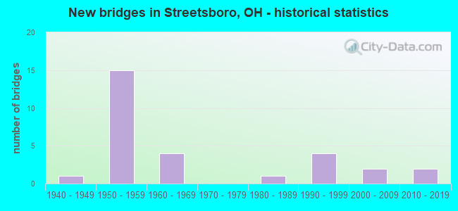
- New bridges - historical statistics
- 11940-1949
- 151950-1959
- 41960-1969
- 11980-1989
- 41990-1999
- 22000-2009
- 22010-2019

- Reconstructed bridges - Historical Statistics
- 41980-1989
- 61990-1999
- 02000-2009
- 22010-2019


- Bridge Condition - Deck
- 16.7%Excellent
- 16.7%Very good
- 38.9%Good
- 16.7%Satisfactory
- 5.6%Fair
- 5.6%Poor

- Bridge Condition - Superstructure
- 5.6%Excellent
- 27.8%Very good
- 55.6%Good
- 11.1%Fair

- Bridge Condition - Substructure
- 5.6%Excellent
- 38.9%Very good
- 33.3%Good
- 22.2%Satisfactory

- Bridge Condition - Channel
- 14.3%Excellent
- 14.3%Very good
- 42.9%Good
- 28.6%Satisfactory

- Bridge Condition - Culverts
- 50.0%Very good
- 50.0%Fair
Find on map >> Show street view
Structure Number: 6700489, Location: 0.4MI WEST OF EXIT 13 (Lat: 41.252839, Lng: -81.367589), Route carried "on" structure: Interstate 480, Year Built: 1954, Status: Open, Structure Length: 4.75m (15.58ft), Average Daily Traffic: 3,337 (year 2015), Truck Traffic: 11%, Average Future Daily Traffic: 4,632 (year 2035), Design Load: HS 20+Mod, Features Intersected: SR14, Facility Carried by Structure: TPK EXIT 187 RAMP
Minimum Vertical Clearance: 30+ m (98+ ft), Kilometerpoint: 2.736, Lanes on structure: 2, Lanes under structure: 4, Base Highway Network: Yes, Toll: On toll road, Owner: State Toll Authority, Approaching Roadway Width: 9.4m (30.8ft), Skew: 20 degrees, Material/Design: Steel continuous, Design/Construction: Stringer/Multi-beam, Number Of Spans In Main Unit: 4, Length of Maximum Span: 15.5m (50.9ft), Curb-To-Curb Width: 9.4m (30.8ft), Out-to-Out Width: 10.3m (33.8ft)
Condition: Deck: Good, Superstructure: Good, Substructure: Good, Operating Rating: 81.0 metric tons, Method Used To Determine Operating Rating: Load Factor (LF) rating reported by rating factor (RF) method using MS18 loading, Inventory Rating: 48.6 metric tons, Method Used To Determine Inventory Rating: Load Factor (LF) rating reported by rating factor (RF) method using MS18 loading, Structural Evaluation: Better than present minimum criteria, Deck Geometry: Meets minimum limits, Underclear: Somewhat better than minimum adequacy, Approach Roadway Alignment: Equal to present desirable criteria, Designated Inspection Frequency: Every 24 months, Inspection Date: May 2021, Deck Structure Type: Concrete Cast-file-Place, Wearing Surface/Protective System: Wearing Surface: Monolithic Concrete
Find on map >> Show street view
Structure Number: 6700586, Location: 2.83 MI E OF SR 303 (Lat: 41.209750, Lng: -81.304131), Route carried "on" structure: State highway 14, Year Built: 1985, Year Reconstructed: 2017, Status: Open, Structure Length: 5.00m (16.40ft), Average Daily Traffic: 19,396 (year 2015), Truck Traffic: 9%, Average Future Daily Traffic: 26,922 (year 2035), Design Load: HL 93, Features Intersected: OVER CUYAHOGA RIVER
Minimum Vertical Clearance: 30+ m (98+ ft), Kilometerpoint: 10.042, Lanes on structure: 2, Base Highway Network: Yes, Owner: State Highway Agency, Approaching Roadway Width: 13.4m (44.0ft), Skew: 1 degrees, Material/Design: Steel continuous, Design/Construction: Stringer/Multi-beam, Number Of Spans In Main Unit: 3, Length of Maximum Span: 18.9m (62.0ft), Curb-To-Curb Width: 13.4m (44.0ft), Out-to-Out Width: 13.4m (44.0ft)
Condition: Deck: Very good, Superstructure: Very good, Substructure: Very good, Channel: Very good, Operating Rating: 42.1 metric tons, Method Used To Determine Operating Rating: Load Factor (LF) rating reported by rating factor (RF) method using MS18 loading, Inventory Rating: 29.2 metric tons, Method Used To Determine Inventory Rating: Load Factor (LF) rating reported by rating factor (RF) method using MS18 loading, Structural Evaluation: Better than present minimum criteria, Deck Geometry: Equal to present minimum criteria, Waterway Adequacy: Equal to present desirable criteria, Approach Roadway Alignment: Equal to present desirable criteria, Designated Inspection Frequency: Every 24 months, Inspection Date: March 2021, Deck Structure Type: Concrete Cast-file-Place, Wearing Surface/Protective System: Wearing Surface: Monolithic Concrete, Deck Protection: Epoxy Coated Reinforcing
Find on map >> Show street view
Structure Number: 670064, Location: 2.90 MI W OF SR 88 (Lat: 41.188169, Lng: -81.281819), Route carried "on" structure: State highway 14, Year Built: 2009, Status: Open, Structure Length: 0.67m (2.20ft), Average Daily Traffic: 15,673 (year 2015), Truck Traffic: 9%, Average Future Daily Traffic: 21,754 (year 2035), Design Load: HS 25 or greater, Features Intersected: BRANCH OF CUYAHOGA RIVER
Minimum Vertical Clearance: 30+ m (98+ ft), Kilometerpoint: 13.132, Lanes on structure: 2, Base Highway Network: Yes, Owner: State Highway Agency, Approaching Roadway Width: 7.3m (24.0ft), Material/Design: Concrete, Design/Construction: Frame, Number Of Spans In Main Unit: 1, Length of Maximum Span: 6.7m (22.0ft), Curb-To-Curb Width: 13.4m (44.0ft), Out-to-Out Width: 13.4m (44.0ft)
Condition: Deck: Very good, Superstructure: Very good, Substructure: Very good, Channel: Good, Operating Rating: 42.1 metric tons, Method Used To Determine Operating Rating: Load and Resistance Factor Rating (LRFR) rating reported by rating factor(RF) method using HL-93 loadings, Inventory Rating: 32.4 metric tons, Method Used To Determine Inventory Rating: Load and Resistance Factor Rating (LRFR) rating reported by rating factor(RF) method using HL-93 loadings, Structural Evaluation: Equal to present desirable criteria, Deck Geometry: Equal to present minimum criteria, Waterway Adequacy: Better than present minimum criteria, Approach Roadway Alignment: Equal to present desirable criteria, Designated Inspection Frequency: Every 24 months, Inspection Date: March 2021, Deck Structure Type: Concrete Cast-file-Place, Wearing Surface/Protective System: Wearing Surface: Bituminous, Membrane: Preformed Fabric, Deck Protection: Epoxy Coated Reinforcing
Find on map >> Show street view
Structure Number: 6704353, Location: 3.02 MI W OF SR 44 (Lat: 41.239761, Lng: -81.378781), Route carried "on" structure: State highway 303, Year Built: 2018, Status: Open, Structure Length: 0.90m (2.95ft), Average Daily Traffic: 8,100 (year 2017), Truck Traffic: 4%, Average Future Daily Traffic: 9,000 (year 2037), Design Load: HL 93, Features Intersected: BR CUYAHOGA RIVER
Minimum Vertical Clearance: 30+ m (98+ ft), Kilometerpoint: 1.127, Lanes on structure: 2, Owner: State Highway Agency, Approaching Roadway Width: 7.3m (24.0ft), Material/Design: Steel, Design/Construction: Culvert, Number Of Spans In Main Unit: 3, Length of Maximum Span: 2.2m (7.2ft)
Condition: Channel: Good, Culverts: Very good, Operating Rating: 42.1 metric tons, Method Used To Determine Operating Rating: Load Factor (LF) rating reported by rating factor (RF) method using MS18 loading, Inventory Rating: 32.4 metric tons, Method Used To Determine Inventory Rating: Load Factor (LF) rating reported by rating factor (RF) method using MS18 loading, Structural Evaluation: Equal to present desirable criteria, Waterway Adequacy: Equal to present minimum criteria, Approach Roadway Alignment: Better than present minimum criteria, Length Of Structure Improvement: 1.52m (4.99ft), Designated Inspection Frequency: Every 24 months, Inspection Date: April 2021, Total Project Cost: $2,406,000
Find on map >> Show street view
Structure Number: 6704778, Location: 1.20 MI W OF IR 80 (Lat: 41.265289, Lng: -81.390069), Route carried "on" structure: Interstate 480, Year Built: 1964, Year Reconstructed: 1999, Status: Open, Structure Length: 4.11m (13.48ft), Average Daily Traffic: 20,850 (year 2015), Truck Traffic: 11%, Average Future Daily Traffic: 28,940 (year 2035), Design Load: HS 20+Mod, Features Intersected: OVER WHEELING&L ERIE RR
Minimum Vertical Clearance: 30+ m (98+ ft), Kilometerpoint: 0.193, Lanes on structure: 2, Base Highway Network: Yes, Owner: State Highway Agency, Approaching Roadway Width: 13.4m (44.0ft), Skew: 1 degrees, Material/Design: Steel continuous, Design/Construction: Stringer/Multi-beam, Number Of Spans In Main Unit: 3, Length of Maximum Span: 15.2m (49.9ft), Curb-To-Curb Width: 18.6m (61.0ft), Out-to-Out Width: 19.6m (64.3ft)
Condition: Deck: Satisfactory, Superstructure: Good, Substructure: Very good, Operating Rating: 87.5 metric tons, Method Used To Determine Operating Rating: Load Factor (LF) rating reported by rating factor (RF) method using MS18 loading, Inventory Rating: 51.8 metric tons, Method Used To Determine Inventory Rating: Load Factor (LF) rating reported by rating factor (RF) method using MS18 loading, Structural Evaluation: Better than present minimum criteria, Deck Geometry: Superior to present desirable criteria, Underclear: Somewhat better than minimum adequacy, Approach Roadway Alignment: Equal to present desirable criteria, Designated Inspection Frequency: Every 12 months, Inspection Date: March 2021, Deck Structure Type: Concrete Cast-file-Place, Wearing Surface/Protective System: Wearing Surface: Monolithic Concrete
Find on map >> Show street view
Structure Number: 6704808, Location: 1.20 MI W OF IR 80 (Lat: 41.264881, Lng: -81.390111), Route carried "on" structure: Interstate 480, Year Built: 1964, Year Reconstructed: 1999, Status: Open, Structure Length: 4.11m (13.48ft), Average Daily Traffic: 20,850 (year 2015), Truck Traffic: 11%, Average Future Daily Traffic: 28,940 (year 2035), Design Load: HS 20+Mod, Features Intersected: OVER WHEELING&L ERIE RR
Minimum Vertical Clearance: 30+ m (98+ ft), Kilometerpoint: 0.193, Lanes on structure: 2, Base Highway Network: Yes, Owner: State Highway Agency, Approaching Roadway Width: 13.4m (44.0ft), Skew: 1 degrees, Material/Design: Steel continuous, Design/Construction: Stringer/Multi-beam, Number Of Spans In Main Unit: 3, Length of Maximum Span: 15.2m (49.9ft), Curb-To-Curb Width: 18.6m (61.0ft), Out-to-Out Width: 19.6m (64.3ft)
Condition: Deck: Satisfactory, Superstructure: Good, Substructure: Very good, Operating Rating: 87.5 metric tons, Method Used To Determine Operating Rating: Load Factor (LF) rating reported by rating factor (RF) method using MS18 loading, Inventory Rating: 51.8 metric tons, Method Used To Determine Inventory Rating: Load Factor (LF) rating reported by rating factor (RF) method using MS18 loading, Structural Evaluation: Better than present minimum criteria, Deck Geometry: Superior to present desirable criteria, Underclear: Somewhat better than minimum adequacy, Approach Roadway Alignment: Equal to present desirable criteria, Designated Inspection Frequency: Every 12 months, Inspection Date: March 2021, Deck Structure Type: Concrete Cast-file-Place, Wearing Surface/Protective System: Wearing Surface: Monolithic Concrete
Find on map >> Show street view
Structure Number: 6704832, Location: 0.52 MI W OF IR 80 (Lat: 41.261689, Lng: -81.377461), Route carried "on" structure: County highway C0197, Year Built: 1964, Year Reconstructed: 2018, Status: Open, Structure Length: 12.68m (41.60ft), Average Daily Traffic: 11,205 (year 2015), Truck Traffic: 4%, Average Future Daily Traffic: 21,864 (year 2035), Design Load: HS 20, Features Intersected: IR 480, Facility Carried by Structure: FROST ROAD
Minimum Vertical Clearance: 30+ m (98+ ft), Kilometerpoint: 1.191, Lanes on structure: 2, Lanes under structure: 4, Owner: State Highway Agency, Approaching Roadway Width: 7.3m (24.0ft), Skew: 4 degrees, Material/Design: Steel continuous, Design/Construction: Stringer/Multi-beam, Number Of Spans In Main Unit: 4, Length of Maximum Span: 38.7m (127.0ft), Curb-To-Curb Width: 13.4m (44.0ft), Out-to-Out Width: 14.4m (47.2ft)
Condition: Deck: Very good, Superstructure: Good, Substructure: Very good, Operating Rating: 48.6 metric tons, Method Used To Determine Operating Rating: Load and Resistance Factor Rating (LRFR) rating reported by rating factor(RF) method using HL-93 loadings, Inventory Rating: 35.6 metric tons, Method Used To Determine Inventory Rating: Load and Resistance Factor Rating (LRFR) rating reported by rating factor(RF) method using HL-93 loadings, Structural Evaluation: Better than present minimum criteria, Deck Geometry: Equal to present minimum criteria, Underclear: High priority of corrective action, Approach Roadway Alignment: Equal to present desirable criteria, Designated Inspection Frequency: Every 24 months, Inspection Date: March 2021, Deck Structure Type: Concrete Cast-file-Place, Wearing Surface/Protective System: Wearing Surface: Monolithic Concrete, Deck Protection: Epoxy Coated Reinforcing
Find on map >> Show street view
Structure Number: 6729258, Location: 1.2MI WEST OF EXIT 187 (Lat: 41.254719, Lng: -81.386919), Route carried "on" structure: Interstate 80K, Year Built: 1954, Year Reconstructed: 1997, Status: Open, Structure Length: 4.60m (15.09ft), Average Daily Traffic: 34,729 (year 2015), Truck Traffic: 30%, Average Future Daily Traffic: 48,204 (year 2035), Design Load: HS 20+Mod, Features Intersected: NS RR, Facility Carried by Structure: I80 OH TPK
Minimum Vertical Clearance: 30+ m (98+ ft), Kilometerpoint: 0.435, Lanes on structure: 6, Base Highway Network: Yes, Toll: On toll road, Owner: State Toll Authority, Approaching Roadway Width: 36.6m (120.1ft), Skew: 31 degrees, Material/Design: Steel continuous, Design/Construction: Stringer/Multi-beam, Number Of Spans In Main Unit: 3, Length of Maximum Span: 16.8m (55.1ft), Curb-To-Curb Width: 37.4m (122.7ft), Out-to-Out Width: 38.3m (125.7ft)
Condition: Deck: Excellent, Superstructure: Good, Substructure: Very good, Operating Rating: 97.2 metric tons, Method Used To Determine Operating Rating: Load Factor (LF) rating reported by rating factor (RF) method using MS18 loading, Inventory Rating: 71.3 metric tons, Method Used To Determine Inventory Rating: Load Factor (LF) rating reported by rating factor (RF) method using MS18 loading, Structural Evaluation: Better than present minimum criteria, Deck Geometry: Superior to present desirable criteria, Underclear: Superior to present desirable criteria, Approach Roadway Alignment: Equal to present desirable criteria, Designated Inspection Frequency: Every 24 months, Inspection Date: May 2021, Deck Structure Type: Concrete Cast-file-Place, Wearing Surface/Protective System: Wearing Surface: Monolithic Concrete, Deck Protection: Epoxy Coated Reinforcing
Find on map >> Show street view
Structure Number: 672929, Location: 0.4MI WEST OF EXIT 13 (Lat: 41.255689, Lng: -81.370831), Route carried "on" structure: Interstate 480, Year Built: 1997, Status: Open, Structure Length: 9.21m (30.22ft), Average Daily Traffic: 3,337 (year 2015), Truck Traffic: 11%, Average Future Daily Traffic: 48,204 (year 2035), Design Load: HS 20+Mod, Features Intersected: I80 OHIO TURNPIKE
Minimum Vertical Clearance: 30+ m (98+ ft), Kilometerpoint: 2.044, Lanes on structure: 2, Lanes under structure: 6, Base Highway Network: Yes, Owner: State Toll Authority, Approaching Roadway Width: 11.6m (38.1ft), Skew: 4 degrees, Material/Design: Steel continuous, Design/Construction: Stringer/Multi-beam, Number Of Spans In Main Unit: 4, Length of Maximum Span: 26.8m (87.9ft), Curb-To-Curb Width: 12.2m (40.0ft), Out-to-Out Width: 13.1m (43.0ft)
Condition: Deck: Good, Superstructure: Very good, Substructure: Good, Operating Rating: 42.1 metric tons, Method Used To Determine Operating Rating: Load Factor (LF) rating reported by rating factor (RF) method using MS18 loading, Inventory Rating: 25.9 metric tons, Method Used To Determine Inventory Rating: Load Factor (LF) rating reported by rating factor (RF) method using MS18 loading, Structural Evaluation: Equal to present minimum criteria, Deck Geometry: Better than present minimum criteria, Underclear: Meets minimum limits, Approach Roadway Alignment: Equal to present minimum criteria, Designated Inspection Frequency: Every 24 months, Inspection Date: May 2021, Deck Structure Type: Concrete Cast-file-Place, Wearing Surface/Protective System: Wearing Surface: Monolithic Concrete, Deck Protection: Epoxy Coated Reinforcing
Find on map >> Show street view
Structure Number: 6729312, Location: 0.4MI WEST OF EXIT 13 (Lat: 41.255681, Lng: -81.371019), Route carried "on" structure: Interstate 480, Year Built: 1997, Status: Open, Structure Length: 9.21m (30.22ft), Average Daily Traffic: 3,337 (year 2015), Truck Traffic: 11%, Average Future Daily Traffic: 48,204 (year 2035), Design Load: HS 20+Mod, Features Intersected: OHIO TURNPIKE
Minimum Vertical Clearance: 30+ m (98+ ft), Kilometerpoint: 2.044, Lanes on structure: 2, Lanes under structure: 6, Base Highway Network: Yes, Owner: State Toll Authority, Approaching Roadway Width: 11.9m (39.0ft), Skew: 4 degrees, Material/Design: Steel continuous, Design/Construction: Stringer/Multi-beam, Number Of Spans In Main Unit: 4, Length of Maximum Span: 26.8m (87.9ft), Curb-To-Curb Width: 15.8m (51.8ft), Out-to-Out Width: 16.7m (54.8ft)
Condition: Deck: Excellent, Superstructure: Good, Substructure: Very good, Operating Rating: 68.0 metric tons, Method Used To Determine Operating Rating: Load Factor (LF) rating reported by rating factor (RF) method using MS18 loading, Inventory Rating: 42.1 metric tons, Method Used To Determine Inventory Rating: Load Factor (LF) rating reported by rating factor (RF) method using MS18 loading, Structural Evaluation: Better than present minimum criteria, Deck Geometry: Superior to present desirable criteria, Underclear: High priority of corrective action, Approach Roadway Alignment: Equal to present minimum criteria, Designated Inspection Frequency: Every 24 months, Inspection Date: May 2021, Deck Structure Type: Concrete Cast-file-Place, Wearing Surface/Protective System: Wearing Surface: Monolithic Concrete, Deck Protection: Epoxy Coated Reinforcing
Find on map >> Show street view
Structure Number: 672932, Location: AT EXIT 187 (Lat: 41.256019, Lng: -81.364250), Route carried "on" structure: Ramp Interstate 480, Year Built: 1954, Year Reconstructed: 1992, Status: Open, Structure Length: 6.55m (21.49ft), Average Daily Traffic: 3,337 (year 2015), Truck Traffic: 11%, Average Future Daily Traffic: 51,789 (year 2035), Design Load: HS 20+Mod, Features Intersected: I80 OH TPK, Facility Carried by Structure: TPK EXIT 187 RAMP
Minimum Vertical Clearance: 30+ m (98+ ft), Kilometerpoint: 3.170, Lanes on structure: 2, Lanes under structure: 7, Toll: On toll road, Owner: State Toll Authority, Approaching Roadway Width: 10.4m (34.1ft), Skew: 20 degrees, Material/Design: Steel continuous, Design/Construction: Stringer/Multi-beam, Number Of Spans In Main Unit: 2, Number Of Approach Spans: 2, Length of Maximum Span: 26.8m (87.9ft), Curb-To-Curb Width: 9.4m (30.8ft), Out-to-Out Width: 10.3m (33.8ft)
Condition: Deck: Good, Superstructure: Very good, Substructure: Good, Operating Rating: 74.5 metric tons, Method Used To Determine Operating Rating: Load Factor (LF) rating reported by rating factor (RF) method using MS18 loading, Inventory Rating: 45.4 metric tons, Method Used To Determine Inventory Rating: Load Factor (LF) rating reported by rating factor (RF) method using MS18 loading, Structural Evaluation: Better than present minimum criteria, Deck Geometry: Somewhat better than minimum adequacy, Underclear: High priority of corrective action, Approach Roadway Alignment: Equal to present desirable criteria, Designated Inspection Frequency: Every 24 months, Inspection Date: May 2021, Deck Structure Type: Concrete Cast-file-Place, Wearing Surface/Protective System: Wearing Surface: Monolithic Concrete, Deck Protection: Epoxy Coated Reinforcing
Find on map >> Show street view
Structure Number: 6729398, Location: 1MI EAST OF EXIT 187 (Lat: 41.253131, Lng: -81.345700), Route carried "on" structure: Interstate 80K, Year Built: 1954, Year Reconstructed: 1997, Status: Open, Structure Length: 5.09m (16.70ft), Average Daily Traffic: 39,896 (year 2015), Truck Traffic: 14%, Average Future Daily Traffic: 55,376 (year 2035), Design Load: HS 20+Mod, Features Intersected: SR43, Facility Carried by Structure: I80 OH TPK
Minimum Vertical Clearance: 30+ m (98+ ft), Kilometerpoint: 3.911, Lanes on structure: 6, Lanes under structure: 2, Base Highway Network: Yes, Toll: On toll road, Owner: State Toll Authority, Approaching Roadway Width: 36.6m (120.1ft), Skew: 31 degrees, Material/Design: Steel continuous, Design/Construction: Stringer/Multi-beam, Number Of Spans In Main Unit: 3, Length of Maximum Span: 19.2m (63.0ft), Curb-To-Curb Width: 37.3m (122.4ft), Out-to-Out Width: 38.3m (125.7ft)
Condition: Deck: Good, Superstructure: Fair, Substructure: Good, Operating Rating: 71.3 metric tons, Method Used To Determine Operating Rating: Load Factor (LF) rating reported by rating factor (RF) method using MS18 loading, Inventory Rating: 42.1 metric tons, Method Used To Determine Inventory Rating: Load Factor (LF) rating reported by rating factor (RF) method using MS18 loading, Structural Evaluation: Somewhat better than minimum adequacy, Deck Geometry: Superior to present desirable criteria, Underclear: Equal to present minimum criteria, Approach Roadway Alignment: Equal to present desirable criteria, Designated Inspection Frequency: Every 12 months, Inspection Date: May 2021, Deck Structure Type: Concrete Cast-file-Place, Wearing Surface/Protective System: Wearing Surface: Monolithic Concrete, Deck Protection: Epoxy Coated Reinforcing
Find on map >> Show street view
Structure Number: 6729436, Location: 2MI EAST OF EXIT 13 (Lat: 41.250961, Lng: -81.326639), Route carried "on" structure: County highway C0551, Year Built: 1954, Year Reconstructed: 1991, Status: Open, Structure Length: 6.28m (20.60ft), Average Daily Traffic: 2,758 (year 2015), Truck Traffic: 5%, Average Future Daily Traffic: 55,376 (year 2035), Design Load: HS 20+Mod, Features Intersected: I80 OHIO TPK, Facility Carried by Structure: PAGE RD
Minimum Vertical Clearance: 30+ m (98+ ft), Kilometerpoint: 1.352, Lanes on structure: 2, Lanes under structure: 6, Owner: State Toll Authority, Approaching Roadway Width: 8.2m (26.9ft), Material/Design: Steel continuous, Design/Construction: Stringer/Multi-beam, Number Of Spans In Main Unit: 4, Length of Maximum Span: 20.4m (66.9ft), Curb-To-Curb Width: 8.1m (26.6ft), Out-to-Out Width: 9.1m (29.9ft)
Condition: Deck: Good, Superstructure: Good, Substructure: Satisfactory, Operating Rating: 74.5 metric tons, Method Used To Determine Operating Rating: Load Factor (LF) rating reported by rating factor (RF) method using MS18 loading, Inventory Rating: 45.4 metric tons, Method Used To Determine Inventory Rating: Load Factor (LF) rating reported by rating factor (RF) method using MS18 loading, Structural Evaluation: Equal to present minimum criteria, Deck Geometry: High priority of corrective action, Underclear: High priority of corrective action, Approach Roadway Alignment: Equal to present desirable criteria, Designated Inspection Frequency: Every 12 months, Inspection Date: May 2021, Deck Structure Type: Concrete Cast-file-Place, Wearing Surface/Protective System: Wearing Surface: Monolithic Concrete, Deck Protection: Epoxy Coated Reinforcing
Find on map >> Show street view
Structure Number: 6729479, Location: 4MI EAST OF EXIT 13 (Lat: 41.247881, Lng: -81.288931), Route carried "on" structure: County highway C0155, Year Built: 1954, Year Reconstructed: 1991, Status: Open, Structure Length: 6.49m (21.29ft), Average Daily Traffic: 20,574 (year 2015), Truck Traffic: 7%, Average Future Daily Traffic: 55,376 (year 2035), Design Load: HS 20+Mod, Features Intersected: I80 OHIO TPK, Facility Carried by Structure: DIAGONAL RD
Minimum Vertical Clearance: 30+ m (98+ ft), Kilometerpoint: 9.077, Lanes on structure: 2, Lanes under structure: 6, Owner: State Toll Authority, Approaching Roadway Width: 8.2m (26.9ft), Skew: 1 degrees, Material/Design: Steel continuous, Design/Construction: Stringer/Multi-beam, Number Of Spans In Main Unit: 4, Length of Maximum Span: 21.0m (68.9ft), Curb-To-Curb Width: 8.1m (26.6ft), Out-to-Out Width: 9.1m (29.9ft)
Condition: Deck: Good, Superstructure: Good, Substructure: Good, Operating Rating: 42.1 metric tons, Method Used To Determine Operating Rating: Load Factor (LF) rating reported by rating factor (RF) method using MS18 loading, Inventory Rating: 25.9 metric tons, Method Used To Determine Inventory Rating: Load Factor (LF) rating reported by rating factor (RF) method using MS18 loading, Structural Evaluation: Equal to present minimum criteria, Deck Geometry: High priority of corrective action, Underclear: High priority of corrective action, Approach Roadway Alignment: Equal to present desirable criteria, Designated Inspection Frequency: Every 24 months, Inspection Date: May 2021, Deck Structure Type: Concrete Cast-file-Place, Wearing Surface/Protective System: Wearing Surface: Monolithic Concrete
Find on map >> Show street view
Structure Number: 6729495, Location: 4.2MI EAST OF EXIT 187 (Lat: 41.248069, Lng: -81.284300), Route carried "on" structure: Interstate 80K, Year Built: 1954, Year Reconstructed: 1997, Status: Open, Structure Length: 7.25m (23.79ft), Average Daily Traffic: 39,896 (year 2015), Truck Traffic: 14%, Average Future Daily Traffic: 55,376 (year 2035), Design Load: HS 20+Mod, Features Intersected: CUYAHOGA RIVER, Facility Carried by Structure: I80 OH TPK
Minimum Vertical Clearance: 30+ m (98+ ft), Kilometerpoint: 9.125, Lanes on structure: 6, Base Highway Network: Yes, Toll: On toll road, Owner: State Toll Authority, Approaching Roadway Width: 36.6m (120.1ft), Skew: 31 degrees, Material/Design: Steel continuous, Design/Construction: Stringer/Multi-beam, Number Of Spans In Main Unit: 3, Length of Maximum Span: 24.7m (81.0ft), Curb-To-Curb Width: 37.4m (122.7ft), Out-to-Out Width: 38.3m (125.7ft)
Condition: Deck: Satisfactory, Superstructure: Good, Substructure: Satisfactory, Channel: Good, Operating Rating: 68.0 metric tons, Method Used To Determine Operating Rating: Load Factor (LF) rating reported by rating factor (RF) method using MS18 loading, Inventory Rating: 38.9 metric tons, Method Used To Determine Inventory Rating: Load Factor (LF) rating reported by rating factor (RF) method using MS18 loading, Structural Evaluation: Equal to present minimum criteria, Deck Geometry: Superior to present desirable criteria, Waterway Adequacy: Equal to present desirable criteria, Approach Roadway Alignment: Equal to present desirable criteria, Designated Inspection Frequency: Every 12 months, Inspection Date: May 2021, Deck Structure Type: Concrete Cast-file-Place, Wearing Surface/Protective System: Wearing Surface: Monolithic Concrete, Deck Protection: Epoxy Coated Reinforcing
Find on map >> Show street view
Structure Number: 6729525, Location: 5.2MI EAST OF EXIT 13 (Lat: 41.246650, Lng: -81.265189), Route carried "on" structure: City street M0210, Year Built: 1954, Year Reconstructed: 1993, Status: Open, Structure Length: 6.19m (20.31ft), Average Daily Traffic: 797 (year 2015), Truck Traffic: 8%, Average Future Daily Traffic: 55,376 (year 2035), Design Load: HS 20+Mod, Features Intersected: I80 OHIO TPK, Facility Carried by Structure: COIT RD
Minimum Vertical Clearance: 30+ m (98+ ft), Kilometerpoint: 1.851, Lanes on structure: 2, Lanes under structure: 6, Owner: State Toll Authority, Approaching Roadway Width: 8.2m (26.9ft), Material/Design: Steel continuous, Design/Construction: Stringer/Multi-beam, Number Of Spans In Main Unit: 4, Length of Maximum Span: 20.1m (65.9ft), Curb-To-Curb Width: 8.1m (26.6ft), Out-to-Out Width: 9.0m (29.5ft)
Condition: Deck: Good, Superstructure: Very good, Substructure: Good, Operating Rating: 45.4 metric tons, Method Used To Determine Operating Rating: Load Factor (LF) rating reported by rating factor (RF) method using MS18 loading, Inventory Rating: 25.9 metric tons, Method Used To Determine Inventory Rating: Load Factor (LF) rating reported by rating factor (RF) method using MS18 loading, Structural Evaluation: Equal to present minimum criteria, Deck Geometry: Somewhat better than minimum adequacy, Underclear: High priority of corrective action, Approach Roadway Alignment: Equal to present desirable criteria, Designated Inspection Frequency: Every 24 months, Inspection Date: May 2021, Deck Structure Type: Concrete Cast-file-Place, Wearing Surface/Protective System: Wearing Surface: Monolithic Concrete
Find on map >> Show street view
Structure Number: 673157, Location: ECKERT DITCH (Lat: 41.197219, Lng: -81.303331), Route carried "on" structure: County highway C154C, Year Built: 1950, Status: Open, Structure Length: 0.85m (2.79ft), Average Daily Traffic: 814 (year 2015), Truck Traffic: 7%, Average Future Daily Traffic: 1,130 (year 2035), Design Load: H 20, Features Intersected: ECKERT DITCH, Facility Carried by Structure: LAKE ROCKWELL
Minimum Vertical Clearance: 30+ m (98+ ft), Kilometerpoint: 4.205, Lanes on structure: 2, Owner: County Highway Agency, Approaching Roadway Width: 6.7m (22.0ft), Material/Design: Steel, Design/Construction: Culvert, Number Of Spans In Main Unit: 2, Length of Maximum Span: 3.7m (12.1ft)
Condition: Channel: Satisfactory, Culverts: Fair, Operating Rating: 48.6 metric tons, Method Used To Determine Operating Rating: Load Factor (LF) rating reported by rating factor (RF) method using MS18 loading, Inventory Rating: 38.9 metric tons, Method Used To Determine Inventory Rating: Load Factor (LF) rating reported by rating factor (RF) method using MS18 loading, Structural Evaluation: Somewhat better than minimum adequacy, Waterway Adequacy: Better than present minimum criteria, Approach Roadway Alignment: Better than present minimum criteria, Designated Inspection Frequency: Every 12 months, Inspection Date: November 2021
Find on map >> Show street view
Structure Number: 6732879, Location: 0.5MI S OF FROST RDCH207 (Lat: 41.253889, Lng: -81.299169), Route carried "on" structure: County highway T0207, Year Built: 1940, Year Reconstructed: 1998, Status: Open, Structure Length: 0.76m (2.49ft), Average Daily Traffic: 351 (year 2015), Truck Traffic: 7%, Average Future Daily Traffic: 487 (year 2035), Design Load: HS 20, Features Intersected: CUYAHOGA TRIBUTARY, Facility Carried by Structure: ELLIMAN RD
Minimum Vertical Clearance: 30+ m (98+ ft), Kilometerpoint: 1.234, Lanes on structure: 2, Owner: County Highway Agency, Approaching Roadway Width: 5.5m (18.0ft), Material/Design: Steel, Design/Construction: Stringer/Multi-beam, Number Of Spans In Main Unit: 1, Length of Maximum Span: 6.7m (22.0ft), Curb-To-Curb Width: 6.9m (22.6ft), Out-to-Out Width: 7.3m (24.0ft)
Condition: Deck: Poor, Superstructure: Good, Substructure: Satisfactory, Channel: Satisfactory, Operating Rating: 61.6 metric tons, Method Used To Determine Operating Rating: Load Factor (LF) rating reported by rating factor (RF) method using MS18 loading, Inventory Rating: 35.6 metric tons, Method Used To Determine Inventory Rating: Load Factor (LF) rating reported by rating factor (RF) method using MS18 loading, Structural Evaluation: Equal to present minimum criteria, Deck Geometry: Meets minimum limits, Waterway Adequacy: Better than present minimum criteria, Approach Roadway Alignment: Better than present minimum criteria, Designated Inspection Frequency: Every 12 months, Inspection Date: September 2021, Deck Structure Type: Corrugated Steel, Wearing Surface/Protective System: Wearing Surface: Bituminous
Find on map >> Show street view
Structure Number: 6735347, Location: OVER CUYAHOGA R (Lat: 41.248611, Lng: -81.269439), Route carried "on" structure: County highway T0210, Year Built: 2011, Status: Open, Structure Length: 3.75m (12.30ft), Average Daily Traffic: 797 (year 2015), Truck Traffic: 8%, Average Future Daily Traffic: 1,106 (year 2035), Design Load: HL 93, Features Intersected: CUYAHOGA R, Facility Carried by Structure: COIT RD
Minimum Vertical Clearance: 30+ m (98+ ft), Kilometerpoint: 2.414, Lanes on structure: 2, Owner: County Highway Agency, Approaching Roadway Width: 8.5m (27.9ft), Material/Design: Prestressed concrete, Design/Construction: Box Beam or Girders - Multiple, Number Of Spans In Main Unit: 1, Length of Maximum Span: 36.9m (121.1ft), Curb-To-Curb Width: 8.5m (27.9ft), Out-to-Out Width: 8.5m (27.9ft)
Condition: Deck: Excellent, Superstructure: Excellent, Substructure: Excellent, Channel: Excellent, Operating Rating: 42.1 metric tons, Method Used To Determine Operating Rating: Load and Resistance Factor Rating (LRFR) rating reported by rating factor(RF) method using HL-93 loadings, Inventory Rating: 35.6 metric tons, Method Used To Determine Inventory Rating: Load and Resistance Factor Rating (LRFR) rating reported by rating factor(RF) method using HL-93 loadings, Structural Evaluation: Superior to present desirable criteria, Deck Geometry: Somewhat better than minimum adequacy, Waterway Adequacy: Equal to present desirable criteria, Approach Roadway Alignment: Equal to present desirable criteria, Designated Inspection Frequency: Every 24 months, Inspection Date: September 2021, Deck Structure Type: Concrete Cast-file-Place, Wearing Surface/Protective System: Wearing Surface: Integral Concrete
Find on map >> Show street view
Structure Number: 6740383, Location: 1.0 MI N.W. OF HUDSON RD (Lat: 41.193611, Lng: -81.380000), Route carried "on" structure: County highway 143, Year Built: 2000, Status: Open, Structure Length: 4.63m (15.19ft), Average Daily Traffic: 1,886 (year 2015), Truck Traffic: 5%, Average Future Daily Traffic: 2,618 (year 2035), Design Load: HS 20, Features Intersected: WHEELING LAKE ERIE R.R., Facility Carried by Structure: JUDSON ROAD
Minimum Vertical Clearance: 30+ m (98+ ft), Kilometerpoint: 2.157, Lanes on structure: 2, Owner: County Highway Agency, Approaching Roadway Width: 7.3m (24.0ft), Skew: 3 degrees, Material/Design: Steel, Design/Construction: Truss - Thru, Number Of Spans In Main Unit: 1, Number Of Approach Spans: 2, Length of Maximum Span: 24.4m (80.1ft), Curb-To-Curb Width: 7.3m (24.0ft), Out-to-Out Width: 7.3m (24.0ft)
Condition: Deck: Fair, Superstructure: Fair, Substructure: Satisfactory, Operating Rating: 55.1 metric tons, Method Used To Determine Operating Rating: Load Factor (LF) rating reported by rating factor (RF) method using MS18 loading, Inventory Rating: 32.4 metric tons, Method Used To Determine Inventory Rating: Load Factor (LF) rating reported by rating factor (RF) method using MS18 loading, Structural Evaluation: Somewhat better than minimum adequacy, Deck Geometry: Meets minimum limits, Underclear: Equal to present minimum criteria, Approach Roadway Alignment: Equal to present minimum criteria, Designated Inspection Frequency: Every 12 months, Critical Feature Inspection Frequency: Every 24 months, Inspection Date: August 2021, Critical Feature Inspection Date: August 2020, Deck Structure Type: Corrugated Steel, Wearing Surface/Protective System: Wearing Surface: Bituminous
Find on map >> Show street view
Structure Number: 6700489, Location: 0.4MI WEST OF EXIT 13 (Lat: 41.252839, Lng: -81.367589), Route carried "under" structure: State highway 14, Year Built: 1954, Structure Length: 0. m, Average Daily Traffic: 26,696 (year 2015), Truck Traffic: 11%, Features Intersected: TPK EXIT 187 RAMP
Minimum Vertical Clearance: 4.70m (15.42ft), Kilometerpoint: 2.575, Lanes on structure: 2, Lanes under structure: 4, Material/Design: Steel continuous, Design/Construction: Stringer/Multi-beam, Length of Maximum Span: 15.5m (50.9ft)
Find on map >> Show street view
Structure Number: 6704832, Location: 0.52 MI W OF IR 80 (Lat: 41.261689, Lng: -81.377461), Route carried "under" structure: Interstate 480, Year Built: 1964, Structure Length: 0. m, Average Daily Traffic: 20,170 (year 2017), Truck Traffic: 2%, Features Intersected: UNDER FROST RD CR-197, Facility Carried by Structure: FROST ROAD
Minimum Vertical Clearance: 4.93m (16.17ft), Kilometerpoint: 1.336, Lanes on structure: 2, Lanes under structure: 4, Material/Design: Steel continuous, Design/Construction: Stringer/Multi-beam, Length of Maximum Span: 38.7m (127.0ft)
Find on map >> Show street view
Structure Number: 672929, Location: 0.4MI WEST OF EXIT 13 (Lat: 41.255689, Lng: -81.370831), Route carried "under" structure: Interstate 80K, Year Built: 1997, Structure Length: 0. m, Average Daily Traffic: 34,729 (year 2015), Truck Traffic: 30%, Features Intersected: I-480 NORTHBOUND, Facility Carried by Structure: I80 OH TPK
Minimum Vertical Clearance: 4.65m (15.26ft), Kilometerpoint: 1.706, Lanes on structure: 2, Lanes under structure: 6, Toll: On toll road, Material/Design: Steel continuous, Design/Construction: Stringer/Multi-beam, Length of Maximum Span: 26.8m (87.9ft)
Find on map >> Show street view
Structure Number: 6729312, Location: 0.4MI WEST OF EXIT 13 (Lat: 41.255681, Lng: -81.371019), Route carried "under" structure: Interstate 80K, Year Built: 1997, Structure Length: 0. m, Average Daily Traffic: 34,729 (year 2015), Truck Traffic: 30%, Features Intersected: SB I480, Facility Carried by Structure: I80 OH TPK
Minimum Vertical Clearance: 4.46m (14.63ft), Kilometerpoint: 1.706, Lanes on structure: 2, Lanes under structure: 6, Toll: On toll road, Material/Design: Steel continuous, Design/Construction: Stringer/Multi-beam, Length of Maximum Span: 26.8m (87.9ft)
Find on map >> Show street view
Structure Number: 672932, Location: AT EXIT 187 (Lat: 41.256019, Lng: -81.364250), Route carried "under" structure: Interstate 80K, Year Built: 1954, Structure Length: 0. m, Average Daily Traffic: 37,312 (year 2015), Truck Traffic: 14%, Features Intersected: TPK EXIT 187 RAMP, Facility Carried by Structure: I80 OH TPK
Minimum Vertical Clearance: 4.67m (15.32ft), Kilometerpoint: 2.317, Lanes on structure: 2, Lanes under structure: 7, Toll: On toll road, Material/Design: Steel continuous, Design/Construction: Stringer/Multi-beam, Length of Maximum Span: 26.8m (87.9ft)
Find on map >> Show street view
Structure Number: 6729398, Location: 1MI EAST OF EXIT 187 (Lat: 41.253131, Lng: -81.345700), Route carried "under" structure: State highway 43, Year Built: 1954, Structure Length: 0. m, Average Daily Traffic: 18,115 (year 2015), Truck Traffic: 7%, Features Intersected: I80 OHIO TPK
Minimum Vertical Clearance: 5.46m (17.91ft), Kilometerpoint: 30.835, Lanes on structure: 6, Lanes under structure: 2, Material/Design: Steel continuous, Design/Construction: Stringer/Multi-beam, Length of Maximum Span: 19.2m (63.0ft)
Find on map >> Show street view
Structure Number: 6729436, Location: 2MI EAST OF EXIT 13 (Lat: 41.250961, Lng: -81.326639), Route carried "under" structure: Interstate 80K, Year Built: 1954, Structure Length: 0. m, Average Daily Traffic: 39,896 (year 2015), Truck Traffic: 14%, Features Intersected: PAGE RD, Facility Carried by Structure: I80 OH TPK
Minimum Vertical Clearance: 4.62m (15.16ft), Kilometerpoint: 5.552, Lanes on structure: 2, Lanes under structure: 6, Toll: On toll road, Material/Design: Steel continuous, Design/Construction: Stringer/Multi-beam, Length of Maximum Span: 20.4m (66.9ft)
Find on map >> Show street view
Structure Number: 6729479, Location: 4MI EAST OF EXIT 13 (Lat: 41.247881, Lng: -81.288931), Route carried "under" structure: Interstate 80K, Year Built: 1954, Structure Length: 0. m, Average Daily Traffic: 39,896 (year 2015), Truck Traffic: 14%, Features Intersected: DIAGONAL RD, Facility Carried by Structure: I80 OH TPK
Minimum Vertical Clearance: 4.57m (14.99ft), Kilometerpoint: 8.739, Lanes on structure: 2, Lanes under structure: 6, Toll: On toll road, Material/Design: Steel continuous, Design/Construction: Stringer/Multi-beam, Length of Maximum Span: 21.0m (68.9ft)
Find on map >> Show street view
Structure Number: 6729525, Location: 5.2MI EAST OF EXIT 13 (Lat: 41.246650, Lng: -81.265189), Route carried "under" structure: Interstate 80K, Year Built: 1954, Structure Length: 0. m, Average Daily Traffic: 39,896 (year 2015), Truck Traffic: 14%, Features Intersected: COIT RD, Facility Carried by Structure: I80 OH TPK
Minimum Vertical Clearance: 4.55m (14.93ft), Kilometerpoint: 10.750, Lanes on structure: 2, Lanes under structure: 6, Toll: On toll road, Material/Design: Steel continuous, Design/Construction: Stringer/Multi-beam, Length of Maximum Span: 20.1m (65.9ft)