Bridge Statistics for Stephenville, Texas (TX)
Condition, Traffic, Stress, Structural Evaluation, Project Costs
- National Bridge Inventory (NBI) Statistics
- 42Number of bridges
- 407ft / 124mTotal length
- $1,810,000Total costs
- 165,044Total average daily traffic
- 22,207Total average daily truck traffic
- National Bridge Inventory (NBI) Registered Bridges for Stephenville
- No street view available for this location
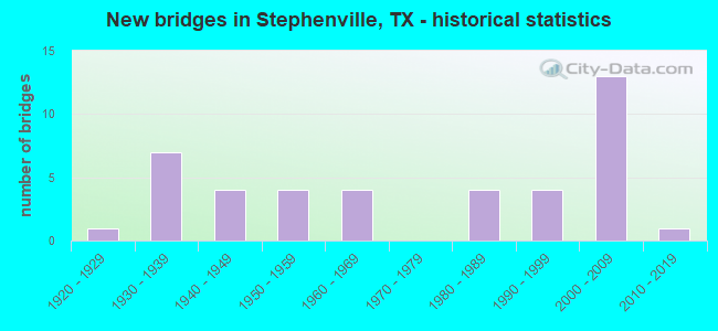
- New bridges - historical statistics
- 11920-1929
- 71930-1939
- 41940-1949
- 41950-1959
- 41960-1969
- 41980-1989
- 41990-1999
- 132000-2009
- 12010-2019

- Reconstructed bridges - Historical Statistics
- 21940-1949
- 11950-1959
- 01960-1969
- 21970-1979
- 51980-1989
- 11990-1999
- 32000-2009
- 12010-2019


- Bridge Condition - Deck
- 9.1%Very good
- 81.8%Good
- 9.1%Satisfactory

- Bridge Condition - Superstructure
- 31.8%Very good
- 50.0%Good
- 13.6%Satisfactory
- 4.5%Fair

- Bridge Condition - Substructure
- 13.6%Very good
- 59.1%Good
- 18.2%Satisfactory
- 9.1%Fair

- Bridge Condition - Channel
- 2.6%Very good
- 56.4%Good
- 33.3%Satisfactory
- 7.7%Fair

- Bridge Condition - Culverts
- 63.2%Good
- 36.8%Satisfactory
Find on map >> Show street view
Structure Number: 20730007904015, Location: 4.4 MI SW OF SH 6 (Lat: 32.042828, Lng: -98.395844), Route carried "on" structure: US 67, Year Built: 1931, Year Reconstructed: 1954, Status: Open, Structure Length: 1.01m (3.31ft), Average Daily Traffic: 4,127 (year 2020), Truck Traffic: 21%, Average Future Daily Traffic: 5,780 (year 2033), Design Load: H 15, Features Intersected: WALNUT CREEK
Minimum Vertical Clearance: 30+ m (98+ ft), Kilometerpoint: 9.020, Lanes on structure: 2, Base Highway Network: Yes, Owner: State Highway Agency, Approaching Roadway Width: 13.4m (44.0ft), Material/Design: Concrete, Design/Construction: Culvert, Number Of Spans In Main Unit: 3, Length of Maximum Span: 3.0m (9.8ft), Out-to-Out Width: 27.6m (90.6ft)
Condition: Channel: Good, Culverts: Satisfactory, Operating Rating: 39.9 metric tons, Method Used To Determine Operating Rating: Load Factor (LF), Inventory Rating: 23.6 metric tons, Method Used To Determine Inventory Rating: Load Factor (LF), Structural Evaluation: Equal to present minimum criteria, Waterway Adequacy: Equal to present minimum criteria, Approach Roadway Alignment: Equal to present desirable criteria, Designated Inspection Frequency: Every 24 months, Inspection Date: August 2020
Find on map >> Show street view
Structure Number: 20730007905024, Location: 1.60 MI SW OF FM 988 (Lat: 32.185564, Lng: -98.264706), Route carried "on" structure: US 67, Year Built: 1936, Year Reconstructed: 2000, Status: Open, Structure Length: 1.16m (3.81ft), Average Daily Traffic: 6,256 (year 2020), Truck Traffic: 14%, Average Future Daily Traffic: 17,690 (year 2033), Design Load: H 15, Features Intersected: ALARM CREEK
Minimum Vertical Clearance: 30+ m (98+ ft), Kilometerpoint: 8.565, Lanes on structure: 4, Base Highway Network: Yes, Owner: State Highway Agency, Approaching Roadway Width: 26.8m (87.9ft), Skew: 29 degrees, Material/Design: Concrete, Design/Construction: Culvert, Number Of Spans In Main Unit: 3, Length of Maximum Span: 3.0m (9.8ft)
Condition: Channel: Good, Culverts: Good, Operating Rating: 39.9 metric tons, Method Used To Determine Operating Rating: Load Factor (LF), Inventory Rating: 23.6 metric tons, Method Used To Determine Inventory Rating: Load Factor (LF), Structural Evaluation: Somewhat better than minimum adequacy, Waterway Adequacy: Equal to present minimum criteria, Approach Roadway Alignment: Equal to present desirable criteria, Length Of Structure Improvement: 1.16m (3.81ft), Designated Inspection Frequency: Every 24 months, Inspection Date: August 2020, Bridge Improvement Cost: $33,000, Roadway Improvement Cost: $8,000, Total Project Cost: $41,000
Find on map >> Show street view
Structure Number: 20730007905039, Location: 0.2 MI E OF FM 914 (Lat: 32.209083, Lng: -98.201547), Route carried "on" structure: US 67, Year Built: 1962, Year Reconstructed: 1985, Status: Open, Structure Length: 20.70m (67.91ft), Average Daily Traffic: 18,925 (year 2020), Truck Traffic: 21%, Average Future Daily Traffic: 23,530 (year 2033), Design Load: H 20, Features Intersected: BOSQUE RIVER
Minimum Vertical Clearance: 30+ m (98+ ft), Kilometerpoint: 1.397, Lanes on structure: 4, Base Highway Network: Yes, Owner: State Highway Agency, Approaching Roadway Width: 20.7m (67.9ft), Skew: 9 degrees, Material/Design: Steel continuous, Design/Construction: Stringer/Multi-beam, Number Of Spans In Main Unit: 4, Number Of Approach Spans: 10, Length of Maximum Span: 22.9m (75.1ft), Curb-To-Curb Width: 20.5m (67.3ft), Out-to-Out Width: 21.3m (69.9ft)
Condition: Deck: Satisfactory, Superstructure: Satisfactory, Substructure: Satisfactory, Channel: Satisfactory, Operating Rating: 40.8 metric tons, Method Used To Determine Operating Rating: Load Factor (LF), Inventory Rating: 24.5 metric tons, Method Used To Determine Inventory Rating: Load Factor (LF), Structural Evaluation: Equal to present minimum criteria, Deck Geometry: Superior to present desirable criteria, Waterway Adequacy: Equal to present minimum criteria, Approach Roadway Alignment: Equal to present desirable criteria, Length Of Structure Improvement: 20.70m (67.91ft), Designated Inspection Frequency: Every 24 months, Inspection Date: August 2020, Bridge Improvement Cost: $1,255,000, Roadway Improvement Cost: $314,000, Total Project Cost: $1,569,000, Deck Structure Type: Concrete Cast-file-Place, Wearing Surface/Protective System: Wearing Surface: Bituminous
Find on map >> Show street view
Structure Number: 2073000790504, Location: 2.2 MI W OF US 281 (Lat: 32.205694, Lng: -98.219017), Route carried "on" structure: US 67, Year Built: 1962, Year Reconstructed: 1985, Status: Open, Structure Length: 7.32m (24.02ft), Average Daily Traffic: 16,313 (year 2020), Truck Traffic: 21%, Average Future Daily Traffic: 20,400 (year 2033), Design Load: HS 20, Features Intersected: AT&SF RR & GROESBECK ST
Minimum Vertical Clearance: 8.13m (26.67ft), Kilometerpoint: 3.273, Lanes on structure: 4, Lanes under structure: 2, Base Highway Network: Yes, Owner: State Highway Agency, Approaching Roadway Width: 20.7m (67.9ft), Skew: 2 degrees, Material/Design: Steel continuous, Design/Construction: Stringer/Multi-beam, Number Of Spans In Main Unit: 4, Length of Maximum Span: 18.9m (62.0ft), Curb-To-Curb Width: 20.5m (67.3ft), Out-to-Out Width: 21.3m (69.9ft)
Condition: Deck: Satisfactory, Superstructure: Good, Substructure: Good, Operating Rating: 50.8 metric tons, Method Used To Determine Operating Rating: Assigned rating based on Load Factor Design (LFD) reported in metric tons, Inventory Rating: 29.9 metric tons, Method Used To Determine Inventory Rating: Assigned rating based on Load Factor Design (LFD) reported in metric tons, Structural Evaluation: Better than present minimum criteria, Deck Geometry: Superior to present desirable criteria, Underclear: Somewhat better than minimum adequacy, Approach Roadway Alignment: Equal to present desirable criteria, Designated Inspection Frequency: Every 24 months, Inspection Date: August 2020, Deck Structure Type: Concrete Cast-file-Place, Wearing Surface/Protective System: Wearing Surface: Bituminous
Find on map >> Show street view
Structure Number: 20730007905048, Location: 3.70 MI SW OF FM 988 (Lat: 32.159997, Lng: -98.286014), Route carried "on" structure: US 67, Year Built: 2000, Status: Open, Structure Length: 0.70m (2.30ft), Average Daily Traffic: 6,256 (year 2020), Truck Traffic: 21%, Average Future Daily Traffic: 12,590 (year 2033), Design Load: HS 20, Features Intersected: TRIB OF GREEN CR
Minimum Vertical Clearance: 30+ m (98+ ft), Kilometerpoint: 12.043, Lanes on structure: 4, Base Highway Network: Yes, Owner: State Highway Agency, Approaching Roadway Width: 26.8m (87.9ft), Skew: 29 degrees, Material/Design: Concrete, Design/Construction: Culvert, Number Of Spans In Main Unit: 3, Length of Maximum Span: 1.8m (5.9ft), Out-to-Out Width: 56.5m (185.4ft)
Condition: Channel: Satisfactory, Culverts: Good, Operating Rating: 44.4 metric tons, Method Used To Determine Operating Rating: Assigned rating based on Load Factor Design (LFD) reported in metric tons, Inventory Rating: 32.7 metric tons, Method Used To Determine Inventory Rating: Assigned rating based on Load Factor Design (LFD) reported in metric tons, Structural Evaluation: Better than present minimum criteria, Waterway Adequacy: Equal to present minimum criteria, Approach Roadway Alignment: Equal to present desirable criteria, Designated Inspection Frequency: Every 48 months, Inspection Date: August 2020
Find on map >> Show street view
Structure Number: 20730007905049, Location: 2.70 MI SW OF FM 988 (Lat: 32.172156, Lng: -98.275847), Route carried "on" structure: US 67, Year Built: 1936, Year Reconstructed: 2000, Status: Open, Structure Length: 0.70m (2.30ft), Average Daily Traffic: 6,256 (year 2020), Truck Traffic: 21%, Average Future Daily Traffic: 12,590 (year 2033), Design Load: H 15, Features Intersected: TRIB OF ALARM CR
Minimum Vertical Clearance: 30+ m (98+ ft), Kilometerpoint: 10.385, Lanes on structure: 4, Owner: State Highway Agency, Approaching Roadway Width: 24.4m (80.1ft), Skew: 29 degrees, Material/Design: Concrete, Design/Construction: Culvert, Number Of Spans In Main Unit: 3, Length of Maximum Span: 1.8m (5.9ft), Out-to-Out Width: 56.5m (185.4ft)
Condition: Channel: Good, Culverts: Satisfactory, Operating Rating: 39.9 metric tons, Method Used To Determine Operating Rating: Load Factor (LF), Inventory Rating: 23.6 metric tons, Method Used To Determine Inventory Rating: Load Factor (LF), Structural Evaluation: Somewhat better than minimum adequacy, Waterway Adequacy: Equal to present minimum criteria, Approach Roadway Alignment: Equal to present desirable criteria, Designated Inspection Frequency: Every 24 months, Inspection Date: August 2020
Find on map >> Show street view
Structure Number: 20730007905051, Location: 1.40 MI SW OF FM 988 (Lat: 32.187300, Lng: -98.263869), Route carried "on" structure: US 67, Year Built: 1936, Year Reconstructed: 2000, Status: Open, Structure Length: 0.76m (2.49ft), Average Daily Traffic: 6,256 (year 2020), Truck Traffic: 14%, Average Future Daily Traffic: 17,690 (year 2033), Features Intersected: ALARM CREEK TRIBUTARY
Minimum Vertical Clearance: 30+ m (98+ ft), Kilometerpoint: 8.359, Lanes on structure: 5, Base Highway Network: Yes, Owner: State Highway Agency, Approaching Roadway Width: 26.8m (87.9ft), Skew: 20 degrees, Material/Design: Concrete, Design/Construction: Culvert, Number Of Spans In Main Unit: 3, Length of Maximum Span: 2.4m (7.9ft)
Condition: Channel: Good, Culverts: Good, Operating Rating: 32.7 metric tons, Method Used To Determine Operating Rating: Field evaluation and documented engineering judgment, Inventory Rating: 24.5 metric tons, Method Used To Determine Inventory Rating: Field evaluation and documented engineering judgment, Structural Evaluation: Equal to present minimum criteria, Waterway Adequacy: Equal to present minimum criteria, Approach Roadway Alignment: Equal to present desirable criteria, Designated Inspection Frequency: Every 24 months, Inspection Date: August 2020
Find on map >> Show street view
Structure Number: 20730007907036, Location: 0.3 MI W OF US 281 (Lat: 32.223608, Lng: -98.196014), Route carried "on" structure: State highway 377, Year Built: 1928, Year Reconstructed: 1949, Status: Open, Structure Length: 10.06m (33.01ft), Average Daily Traffic: 5,560 (year 2013), Truck Traffic: 18%, Average Future Daily Traffic: 7,790 (year 2033), Design Load: H 15, Features Intersected: BOSQUE RIVER
Minimum Vertical Clearance: 30+ m (98+ ft), Kilometerpoint: 3.928, Lanes on structure: 2, Owner: State Highway Agency, Approaching Roadway Width: 9.1m (29.9ft), Material/Design: Concrete, Design/Construction: Tee Beam, Number Of Spans In Main Unit: 10, Length of Maximum Span: 10.1m (33.1ft), Curb or Sidewalk Widths: Left: 1.5m (4.9ft), Right: 1.5m (4.9ft), Curb-To-Curb Width: 9.1m (29.9ft), Out-to-Out Width: 12.6m (41.3ft)
Condition: Deck: Good, Superstructure: Fair, Substructure: Fair, Channel: Satisfactory, Operating Rating: 40.8 metric tons, Method Used To Determine Operating Rating: Load Factor (LF), Inventory Rating: 24.5 metric tons, Method Used To Determine Inventory Rating: Load Factor (LF), Structural Evaluation: Somewhat better than minimum adequacy, Deck Geometry: Meets minimum limits, Waterway Adequacy: Equal to present minimum criteria, Approach Roadway Alignment: Equal to present desirable criteria, Designated Inspection Frequency: Every 24 months, Inspection Date: August 2020, Deck Structure Type: Concrete Cast-file-Place, Wearing Surface/Protective System: Wearing Surface: Bituminous
Find on map >> Show street view
Structure Number: 2073002500301, Location: 0.7 MI N OF US 377 BUS (Lat: 32.236906, Lng: -98.194083), Route carried "on" structure: US 281, Year Built: 1936, Year Reconstructed: 1993, Status: Open, Structure Length: 1.19m (3.90ft), Average Daily Traffic: 9,318 (year 2020), Truck Traffic: 9%, Average Future Daily Traffic: 11,350 (year 2033), Design Load: H 15, Features Intersected: TRIB TO DRY BRANCH
Minimum Vertical Clearance: 30+ m (98+ ft), Kilometerpoint: 33.445, Lanes on structure: 2, Base Highway Network: Yes, Owner: State Highway Agency, Approaching Roadway Width: 13.4m (44.0ft), Material/Design: Concrete, Design/Construction: Culvert, Number Of Spans In Main Unit: 5, Length of Maximum Span: 2.1m (6.9ft), Curb-To-Curb Width: 18.0m (59.1ft), Out-to-Out Width: 20.9m (68.6ft)
Condition: Channel: Good, Culverts: Good, Operating Rating: 32.7 metric tons, Method Used To Determine Operating Rating: Field evaluation and documented engineering judgment, Inventory Rating: 24.5 metric tons, Method Used To Determine Inventory Rating: Field evaluation and documented engineering judgment, Structural Evaluation: Equal to present minimum criteria, Deck Geometry: Superior to present desirable criteria, Waterway Adequacy: Equal to present minimum criteria, Approach Roadway Alignment: Equal to present desirable criteria, Designated Inspection Frequency: Every 24 months, Inspection Date: August 2020, Deck Structure Type: Concrete Cast-file-Place, Wearing Surface/Protective System: Wearing Surface: Bituminous
Find on map >> Show street view
Structure Number: 20730025003022, Location: 0.4 MI N OF US 377 (Lat: 32.240964, Lng: -98.194897), Route carried "on" structure: US 281, Year Built: 1994, Status: Open, Structure Length: 7.62m (25.00ft), Average Daily Traffic: 9,318 (year 2020), Truck Traffic: 9%, Average Future Daily Traffic: 11,350 (year 2033), Design Load: HS 20, Features Intersected: AT & SF RAILROAD
Minimum Vertical Clearance: 30+ m (98+ ft), Kilometerpoint: 33.120, Lanes on structure: 3, Base Highway Network: Yes, Owner: State Highway Agency, Approaching Roadway Width: 18.9m (62.0ft), Skew: 5 degrees, Material/Design: Prestressed concrete, Design/Construction: Stringer/Multi-beam, Number Of Spans In Main Unit: 3, Length of Maximum Span: 26.2m (86.0ft), Curb-To-Curb Width: 17.9m (58.7ft), Out-to-Out Width: 18.9m (62.0ft)
Condition: Deck: Good, Superstructure: Good, Substructure: Good, Operating Rating: 54.4 metric tons, Method Used To Determine Operating Rating: Assigned rating based on Load Factor Design (LFD) reported in metric tons, Inventory Rating: 32.7 metric tons, Method Used To Determine Inventory Rating: Assigned rating based on Load Factor Design (LFD) reported in metric tons, Structural Evaluation: Better than present minimum criteria, Deck Geometry: Superior to present desirable criteria, Underclear: Better than present minimum criteria, Approach Roadway Alignment: Equal to present desirable criteria, Designated Inspection Frequency: Every 24 months, Inspection Date: August 2020, Deck Structure Type: Corrugated Steel
Find on map >> Show street view
Structure Number: 20730025004005, Location: 1.4 MI S OF US 67 (Lat: 32.194261, Lng: -98.177856), Route carried "on" structure: US 281, Year Built: 1934, Year Reconstructed: 1961, Status: Open, Structure Length: 2.59m (8.50ft), Average Daily Traffic: 6,197 (year 2020), Truck Traffic: 15%, Average Future Daily Traffic: 3,960 (year 2033), Design Load: H 15, Features Intersected: POLE HOLLOW BRANCH
Minimum Vertical Clearance: 30+ m (98+ ft), Kilometerpoint: 36.872, Lanes on structure: 2, Base Highway Network: Yes, Owner: State Highway Agency, Approaching Roadway Width: 11.0m (36.1ft), Material/Design: Concrete, Design/Construction: Tee Beam, Number Of Spans In Main Unit: 3, Length of Maximum Span: 8.5m (27.9ft), Curb-To-Curb Width: 13.4m (44.0ft), Out-to-Out Width: 14.0m (45.9ft)
Condition: Deck: Good, Superstructure: Good, Substructure: Good, Channel: Good, Operating Rating: 59.9 metric tons, Method Used To Determine Operating Rating: Load Factor (LF), Inventory Rating: 36.3 metric tons, Method Used To Determine Inventory Rating: Load Factor (LF), Structural Evaluation: Better than present minimum criteria, Deck Geometry: Equal to present minimum criteria, Waterway Adequacy: Equal to present minimum criteria, Approach Roadway Alignment: Equal to present desirable criteria, Designated Inspection Frequency: Every 24 months, Inspection Date: August 2020, Deck Structure Type: Concrete Cast-file-Place, Wearing Surface/Protective System: Wearing Surface: Bituminous
Find on map >> Show street view
Structure Number: 20730025004006, Location: 2.4 MI S OF US 67 (Lat: 32.184125, Lng: -98.165650), Route carried "on" structure: US 281, Year Built: 1934, Year Reconstructed: 2018, Status: Open, Structure Length: 1.07m (3.51ft), Average Daily Traffic: 6,197 (year 2020), Truck Traffic: 12%, Average Future Daily Traffic: 7,310 (year 2033), Design Load: H 15, Features Intersected: HASSLER BRANCH
Minimum Vertical Clearance: 30+ m (98+ ft), Kilometerpoint: 40.110, Lanes on structure: 3, Owner: State Highway Agency, Approaching Roadway Width: 14.9m (48.9ft), Material/Design: Concrete, Design/Construction: Culvert, Number Of Spans In Main Unit: 4, Length of Maximum Span: 2.4m (7.9ft), Curb-To-Curb Width: 14.8m (48.6ft), Out-to-Out Width: 17.2m (56.4ft)
Condition: Channel: Good, Culverts: Satisfactory, Operating Rating: 39.9 metric tons, Method Used To Determine Operating Rating: Load Factor (LF), Inventory Rating: 23.6 metric tons, Method Used To Determine Inventory Rating: Load Factor (LF), Structural Evaluation: Somewhat better than minimum adequacy, Deck Geometry: Equal to present minimum criteria, Waterway Adequacy: Equal to present minimum criteria, Approach Roadway Alignment: Equal to present desirable criteria, Designated Inspection Frequency: Every 24 months, Inspection Date: August 2020, Deck Structure Type: Concrete Cast-file-Place, Wearing Surface/Protective System: Wearing Surface: Bituminous
Find on map >> Show street view
Structure Number: 20730025007103, Location: 0.40 MI N OF US 377 (Lat: 32.216031, Lng: -98.199058), Route carried "on" structure: State highway 108, Year Built: 2008, Status: Open, Structure Length: 12.50m (41.01ft), Average Daily Traffic: 6,464 (year 2020), Truck Traffic: 9%, Average Future Daily Traffic: 9,420 (year 2033), Design Load: HL 93, Features Intersected: NORTH BOSQUE RIVER
Minimum Vertical Clearance: 30+ m (98+ ft), Kilometerpoint: 2.126, Lanes on structure: 2, Base Highway Network: Yes, Owner: State Highway Agency, Approaching Roadway Width: 11.6m (38.1ft), Skew: 3 degrees, Material/Design: Prestressed concrete, Design/Construction: Stringer/Multi-beam, Number Of Spans In Main Unit: 4, Length of Maximum Span: 33.5m (109.9ft), Curb or Sidewalk Widths: Left: 2.4m (7.9ft), Right: 2.4m (7.9ft), Curb-To-Curb Width: 12.2m (40.0ft), Out-to-Out Width: 17.7m (58.1ft)
Condition: Deck: Good, Superstructure: Very good, Substructure: Good, Channel: Satisfactory, Operating Rating: 54.4 metric tons, Method Used To Determine Operating Rating: Assigned ratings based on Load and Resistance Factor Design (LRFD) reported in metric tons, Inventory Rating: 32.7 metric tons, Method Used To Determine Inventory Rating: Assigned ratings based on Load and Resistance Factor Design (LRFD) reported in metric tons, Structural Evaluation: Better than present minimum criteria, Deck Geometry: Somewhat better than minimum adequacy, Waterway Adequacy: Superior to present desirable criteria, Approach Roadway Alignment: Equal to present desirable criteria, Designated Inspection Frequency: Every 24 months, Inspection Date: August 2020, Deck Structure Type: Concrete Precast Panels
Find on map >> Show street view
Structure Number: 20730025901057, Location: 1.00 MI SE OF US 281 (Lat: 32.206417, Lng: -98.170317), Route carried "on" structure: US 67, Year Built: 1954, Status: Open, Structure Length: 2.29m (7.51ft), Average Daily Traffic: 4,681 (year 2020), Truck Traffic: 13%, Average Future Daily Traffic: 6,950 (year 2033), Design Load: H 20, Features Intersected: POLE HOLLOW BR
Minimum Vertical Clearance: 30+ m (98+ ft), Kilometerpoint: 26.902, Lanes on structure: 2, Base Highway Network: Yes, Owner: State Highway Agency, Approaching Roadway Width: 11.6m (38.1ft), Material/Design: Concrete, Design/Construction: Slab, Number Of Spans In Main Unit: 3, Length of Maximum Span: 7.6m (24.9ft), Curb-To-Curb Width: 11.6m (38.1ft), Out-to-Out Width: 12.2m (40.0ft)
Condition: Deck: Good, Superstructure: Good, Substructure: Satisfactory, Channel: Good, Operating Rating: 44.4 metric tons, Method Used To Determine Operating Rating: Load Factor (LF), Inventory Rating: 29.0 metric tons, Method Used To Determine Inventory Rating: Load Factor (LF), Structural Evaluation: Equal to present minimum criteria, Deck Geometry: Somewhat better than minimum adequacy, Waterway Adequacy: Equal to present minimum criteria, Approach Roadway Alignment: Equal to present desirable criteria, Designated Inspection Frequency: Every 24 months, Inspection Date: August 2020, Deck Structure Type: Concrete Cast-file-Place, Wearing Surface/Protective System: Wearing Surface: Bituminous
Find on map >> Show street view
Structure Number: 20730025901058, Location: 2.60 MI SE OF US 281 (Lat: 32.198231, Lng: -98.143783), Route carried "on" structure: US 67, Year Built: 1954, Status: Open, Structure Length: 0.94m (3.08ft), Average Daily Traffic: 4,681 (year 2020), Truck Traffic: 13%, Average Future Daily Traffic: 6,950 (year 2033), Features Intersected: TRIB OF N BOSQUE RI
Minimum Vertical Clearance: 30+ m (98+ ft), Kilometerpoint: 24.261, Lanes on structure: 2, Base Highway Network: Yes, Owner: State Highway Agency, Approaching Roadway Width: 10.4m (34.1ft), Material/Design: Concrete, Design/Construction: Culvert, Number Of Spans In Main Unit: 4, Length of Maximum Span: 2.1m (6.9ft), Curb-To-Curb Width: 10.8m (35.4ft), Out-to-Out Width: 13.8m (45.3ft)
Condition: Channel: Fair, Culverts: Satisfactory, Operating Rating: 39.9 metric tons, Method Used To Determine Operating Rating: Load Factor (LF), Inventory Rating: 23.6 metric tons, Method Used To Determine Inventory Rating: Load Factor (LF), Structural Evaluation: Equal to present minimum criteria, Deck Geometry: Somewhat better than minimum adequacy, Waterway Adequacy: Equal to present minimum criteria, Approach Roadway Alignment: Equal to present desirable criteria, Designated Inspection Frequency: Every 24 months, Inspection Date: August 2020, Deck Structure Type: Concrete Cast-file-Place, Wearing Surface/Protective System: Wearing Surface: Bituminous
Find on map >> Show street view
Structure Number: 20730034304022, Location: 0.85 MI S OF FM 3025 (Lat: 32.288689, Lng: -98.249150), Route carried "on" structure: State highway 108, Year Built: 1944, Year Reconstructed: 1996, Status: Open, Structure Length: 0.82m (2.69ft), Average Daily Traffic: 2,312 (year 2020), Truck Traffic: 14%, Average Future Daily Traffic: 3,450 (year 2033), Design Load: H 15, Features Intersected: TRIB OF N FK N BOSQUE RI
Minimum Vertical Clearance: 30+ m (98+ ft), Kilometerpoint: 29.033, Lanes on structure: 2, Base Highway Network: Yes, Owner: State Highway Agency, Approaching Roadway Width: 13.4m (44.0ft), Skew: 4 degrees, Material/Design: Concrete, Design/Construction: Culvert, Number Of Spans In Main Unit: 2, Length of Maximum Span: 2.4m (7.9ft)
Condition: Channel: Fair, Culverts: Satisfactory, Operating Rating: 32.7 metric tons, Method Used To Determine Operating Rating: Field evaluation and documented engineering judgment, Inventory Rating: 24.5 metric tons, Method Used To Determine Inventory Rating: Field evaluation and documented engineering judgment, Structural Evaluation: Equal to present minimum criteria, Waterway Adequacy: Equal to present minimum criteria, Approach Roadway Alignment: Equal to present desirable criteria, Designated Inspection Frequency: Every 24 months, Inspection Date: August 2020
Find on map >> Show street view
Structure Number: 20730034304033, Location: 0.50 MI NW OF FM 8 (Lat: 32.237844, Lng: -98.214533), Route carried "on" structure: State highway 108, Year Built: 1999, Status: Open, Structure Length: 5.03m (16.50ft), Average Daily Traffic: 5,706 (year 2020), Truck Traffic: 9%, Average Future Daily Traffic: 7,350 (year 2033), Design Load: HS 20, Features Intersected: S FK NORTH BOSQUE RIVER
Minimum Vertical Clearance: 30+ m (98+ ft), Kilometerpoint: 35.581, Lanes on structure: 2, Base Highway Network: Yes, Owner: State Highway Agency, Approaching Roadway Width: 11.6m (38.1ft), Material/Design: Prestressed concrete, Design/Construction: Stringer/Multi-beam, Number Of Spans In Main Unit: 2, Length of Maximum Span: 25.0m (82.0ft), Curb-To-Curb Width: 12.1m (39.7ft), Out-to-Out Width: 12.6m (41.3ft)
Condition: Deck: Good, Superstructure: Very good, Substructure: Very good, Channel: Good, Operating Rating: 54.4 metric tons, Method Used To Determine Operating Rating: Assigned rating based on Load Factor Design (LFD) reported in metric tons, Inventory Rating: 32.7 metric tons, Method Used To Determine Inventory Rating: Assigned rating based on Load Factor Design (LFD) reported in metric tons, Structural Evaluation: Equal to present desirable criteria, Deck Geometry: Somewhat better than minimum adequacy, Waterway Adequacy: Superior to present desirable criteria, Approach Roadway Alignment: Equal to present desirable criteria, Designated Inspection Frequency: Every 24 months, Inspection Date: August 2020, Deck Structure Type: Concrete Precast Panels, Wearing Surface/Protective System: Deck Protection: Epoxy Coated Reinforcing
Find on map >> Show street view
Structure Number: 20730034304034, Location: 1.05 MI NW OF FM 2303 (Lat: 32.253589, Lng: -98.225144), Route carried "on" structure: State highway 108, Year Built: 1999, Status: Open, Structure Length: 7.19m (23.59ft), Average Daily Traffic: 3,759 (year 2020), Truck Traffic: 14%, Average Future Daily Traffic: 4,740 (year 2033), Design Load: HS 20, Features Intersected: N FK N BOSQUE RI
Minimum Vertical Clearance: 30+ m (98+ ft), Kilometerpoint: 33.624, Lanes on structure: 2, Base Highway Network: Yes, Owner: State Highway Agency, Approaching Roadway Width: 12.2m (40.0ft), Skew: 4 degrees, Material/Design: Prestressed concrete, Design/Construction: Stringer/Multi-beam, Number Of Spans In Main Unit: 3, Length of Maximum Span: 24.1m (79.1ft), Curb-To-Curb Width: 11.9m (39.0ft), Out-to-Out Width: 12.6m (41.3ft)
Condition: Deck: Good, Superstructure: Very good, Substructure: Very good, Channel: Satisfactory, Operating Rating: 54.4 metric tons, Method Used To Determine Operating Rating: Assigned rating based on Load Factor Design (LFD) reported in metric tons, Inventory Rating: 32.7 metric tons, Method Used To Determine Inventory Rating: Assigned rating based on Load Factor Design (LFD) reported in metric tons, Structural Evaluation: Equal to present desirable criteria, Deck Geometry: Somewhat better than minimum adequacy, Waterway Adequacy: Equal to present desirable criteria, Approach Roadway Alignment: Equal to present desirable criteria, Designated Inspection Frequency: Every 24 months, Inspection Date: August 2020, Deck Structure Type: Concrete Precast Panels, Wearing Surface/Protective System: Deck Protection: Epoxy Coated Reinforcing
Find on map >> Show street view
Structure Number: 20730055002002, Location: 4.90 MI E OF FM 219 S (Lat: 32.233400, Lng: -98.296706), Route carried "on" structure: State highway 8, Year Built: 1940, Year Reconstructed: 1994, Status: Open, Structure Length: 1.37m (4.49ft), Average Daily Traffic: 3,066 (year 2020), Truck Traffic: 4%, Average Future Daily Traffic: 3,520 (year 2033), Design Load: H 15, Features Intersected: GOOSE BRANCH
Minimum Vertical Clearance: 30+ m (98+ ft), Kilometerpoint: 24.937, Lanes on structure: 2, Base Highway Network: Yes, Owner: State Highway Agency, Approaching Roadway Width: 12.2m (40.0ft), Material/Design: Concrete, Design/Construction: Culvert, Number Of Spans In Main Unit: 4, Length of Maximum Span: 3.0m (9.8ft), Curb-To-Curb Width: 12.2m (40.0ft), Out-to-Out Width: 13.1m (43.0ft)
Condition: Channel: Satisfactory, Culverts: Good, Operating Rating: 32.7 metric tons, Method Used To Determine Operating Rating: Field evaluation and documented engineering judgment, Inventory Rating: 24.5 metric tons, Method Used To Determine Inventory Rating: Field evaluation and documented engineering judgment, Structural Evaluation: Equal to present minimum criteria, Deck Geometry: Equal to present minimum criteria, Waterway Adequacy: Equal to present minimum criteria, Approach Roadway Alignment: Equal to present desirable criteria, Designated Inspection Frequency: Every 24 months, Inspection Date: August 2020, Deck Structure Type: Concrete Cast-file-Place, Wearing Surface/Protective System: Wearing Surface: Bituminous
Find on map >> Show street view
Structure Number: 20730055002003, Location: 6.00 MI E OF FM 219 S (Lat: 32.229336, Lng: -98.278764), Route carried "on" structure: State highway 8, Year Built: 1940, Year Reconstructed: 1994, Status: Open, Structure Length: 0.70m (2.30ft), Average Daily Traffic: 3,066 (year 2020), Truck Traffic: 4%, Average Future Daily Traffic: 3,520 (year 2033), Design Load: H 15, Features Intersected: S FK N BOSQUE RIVER BR
Minimum Vertical Clearance: 30+ m (98+ ft), Kilometerpoint: 26.728, Lanes on structure: 2, Base Highway Network: Yes, Owner: State Highway Agency, Approaching Roadway Width: 12.2m (40.0ft), Material/Design: Concrete, Design/Construction: Culvert, Number Of Spans In Main Unit: 2, Length of Maximum Span: 3.0m (9.8ft), Curb-To-Curb Width: 12.3m (40.4ft), Out-to-Out Width: 12.8m (42.0ft)
Condition: Channel: Good, Culverts: Satisfactory, Operating Rating: 32.7 metric tons, Method Used To Determine Operating Rating: Field evaluation and documented engineering judgment, Inventory Rating: 24.5 metric tons, Method Used To Determine Inventory Rating: Field evaluation and documented engineering judgment, Structural Evaluation: Equal to present minimum criteria, Deck Geometry: Equal to present minimum criteria, Waterway Adequacy: Equal to present minimum criteria, Approach Roadway Alignment: Equal to present desirable criteria, Designated Inspection Frequency: Every 24 months, Inspection Date: August 2020, Deck Structure Type: Concrete Cast-file-Place, Wearing Surface/Protective System: Wearing Surface: Bituminous
Find on map >> Show street view
Structure Number: 20730055002027, Location: 0.9 MI W OF US 281 (Lat: 32.235058, Lng: -98.204058), Route carried "on" structure: State highway 8, Year Built: 1966, Year Reconstructed: 1978, Status: Open, Structure Length: 4.91m (16.11ft), Average Daily Traffic: 9,546 (year 2020), Truck Traffic: 10%, Average Future Daily Traffic: 9,460 (year 2033), Design Load: H 15, Features Intersected: BOSQUE RIVER
Minimum Vertical Clearance: 30+ m (98+ ft), Kilometerpoint: 34.255, Lanes on structure: 2, Owner: State Highway Agency, Approaching Roadway Width: 12.2m (40.0ft), Material/Design: Concrete, Design/Construction: Stringer/Multi-beam, Number Of Spans In Main Unit: 1, Number Of Approach Spans: 4, Length of Maximum Span: 12.2m (40.0ft), Curb-To-Curb Width: 12.2m (40.0ft), Out-to-Out Width: 12.7m (41.7ft)
Condition: Deck: Good, Superstructure: Good, Substructure: Good, Channel: Satisfactory, Operating Rating: 39.0 metric tons, Method Used To Determine Operating Rating: Load Factor (LF), Inventory Rating: 22.7 metric tons, Method Used To Determine Inventory Rating: Load Factor (LF), Structural Evaluation: Somewhat better than minimum adequacy, Deck Geometry: Somewhat better than minimum adequacy, Waterway Adequacy: Equal to present minimum criteria, Approach Roadway Alignment: Equal to present desirable criteria, Designated Inspection Frequency: Every 24 months, Inspection Date: August 2020, Deck Structure Type: Concrete Cast-file-Place, Wearing Surface/Protective System: Wearing Surface: Bituminous
Find on map >> Show street view
Structure Number: 20730055002031, Location: 0.10 MI W OF FM 988 (Lat: 32.226214, Lng: -98.233525), Route carried "on" structure: State highway 8, Year Built: 1942, Year Reconstructed: 1983, Status: Open, Structure Length: 0.64m (2.10ft), Average Daily Traffic: 5,506 (year 2020), Truck Traffic: 4%, Average Future Daily Traffic: 5,930 (year 2033), Features Intersected: NORTH BOSQUE RIVER S BR
Minimum Vertical Clearance: 30+ m (98+ ft), Kilometerpoint: 31.167, Lanes on structure: 4, Owner: State Highway Agency, Approaching Roadway Width: 18.3m (60.0ft), Material/Design: Concrete, Design/Construction: Culvert, Number Of Spans In Main Unit: 4, Length of Maximum Span: 1.8m (5.9ft)
Condition: Channel: Satisfactory, Culverts: Good, Operating Rating: 32.7 metric tons, Method Used To Determine Operating Rating: Field evaluation and documented engineering judgment, Inventory Rating: 24.5 metric tons, Method Used To Determine Inventory Rating: Field evaluation and documented engineering judgment, Structural Evaluation: Equal to present minimum criteria, Waterway Adequacy: Equal to present minimum criteria, Approach Roadway Alignment: Equal to present desirable criteria, Designated Inspection Frequency: Every 24 months, Inspection Date: August 2020
Find on map >> Show street view
Structure Number: 20730055003038, Location: 0.7 MI S OF US 377 (Lat: 32.195989, Lng: -98.203811), Route carried "on" structure: State highway 914, Year Built: 2008, Status: Open, Structure Length: 2.29m (7.51ft), Average Daily Traffic: 3,431 (year 2020), Truck Traffic: 7%, Average Future Daily Traffic: 4,460 (year 2033), Design Load: HL 93, Features Intersected: TRIB OF BOSQUE RIVER
Minimum Vertical Clearance: 30+ m (98+ ft), Kilometerpoint: 1.259, Lanes on structure: 2, Owner: State Highway Agency, Approaching Roadway Width: 8.5m (27.9ft), Skew: 1 degrees, Material/Design: Concrete continuous, Design/Construction: Slab, Number Of Spans In Main Unit: 3, Length of Maximum Span: 7.6m (24.9ft), Curb-To-Curb Width: 12.1m (39.7ft), Out-to-Out Width: 12.8m (42.0ft)
Condition: Deck: Good, Superstructure: Good, Substructure: Good, Channel: Good, Operating Rating: 54.4 metric tons, Method Used To Determine Operating Rating: Assigned ratings based on Load and Resistance Factor Design (LRFD) reported in metric tons, Inventory Rating: 32.7 metric tons, Method Used To Determine Inventory Rating: Assigned ratings based on Load and Resistance Factor Design (LRFD) reported in metric tons, Structural Evaluation: Better than present minimum criteria, Deck Geometry: Somewhat better than minimum adequacy, Waterway Adequacy: Superior to present desirable criteria, Approach Roadway Alignment: Equal to present desirable criteria, Designated Inspection Frequency: Every 24 months, Inspection Date: August 2020, Deck Structure Type: Concrete Cast-file-Place
Find on map >> Show street view
Structure Number: 20730055003039, Location: 4.6 Mi. S. of US 377 (Lat: 32.142600, Lng: -98.194319), Route carried "on" structure: State highway 914, Year Built: 2018, Status: Open, Structure Length: 4.27m (14.01ft), Average Daily Traffic: 1,336 (year 2020), Truck Traffic: 6%, Average Future Daily Traffic: 1,540 (year 2035), Design Load: HL 93, Features Intersected: Alarm Creek
Minimum Vertical Clearance: 30+ m (98+ ft), Kilometerpoint: 7.611, Lanes on structure: 2, Owner: State Highway Agency, Approaching Roadway Width: 13.4m (44.0ft), Material/Design: Prestressed concrete, Design/Construction: Stringer/Multi-beam, Number Of Spans In Main Unit: 3, Length of Maximum Span: 15.2m (49.9ft), Curb-To-Curb Width: 13.4m (44.0ft), Out-to-Out Width: 14.0m (45.9ft)
Condition: Deck: Good, Superstructure: Very good, Substructure: Very good, Channel: Very good, Operating Rating: 54.4 metric tons, Method Used To Determine Operating Rating: Assigned ratings based on Load and Resistance Factor Design (LRFD) reported in metric tons, Inventory Rating: 32.7 metric tons, Method Used To Determine Inventory Rating: Assigned ratings based on Load and Resistance Factor Design (LRFD) reported in metric tons, Structural Evaluation: Equal to present desirable criteria, Deck Geometry: Equal to present desirable criteria, Waterway Adequacy: Superior to present desirable criteria, Approach Roadway Alignment: Equal to present desirable criteria, Designated Inspection Frequency: Every 24 months, Inspection Date: August 2020, Deck Structure Type: Concrete Precast Panels, Wearing Surface/Protective System: Deck Protection: Epoxy Coated Reinforcing
Find on map >> Show street view
Structure Number: 20730159702009, Location: 1.8 MI W OF FM 914 (Lat: 32.157303, Lng: -98.218053), Route carried "on" structure: State highway 847, Year Built: 1957, Status: Open, Structure Length: 2.74m (8.99ft), Average Daily Traffic: 1,253 (year 2020), Truck Traffic: 9%, Average Future Daily Traffic: 1,410 (year 2033), Design Load: H 15, Features Intersected: ALARM CREEK
Minimum Vertical Clearance: 30+ m (98+ ft), Kilometerpoint: 14.193, Lanes on structure: 2, Owner: State Highway Agency, Approaching Roadway Width: 6.1m (20.0ft), Material/Design: Concrete, Design/Construction: Stringer/Multi-beam, Number Of Spans In Main Unit: 3, Length of Maximum Span: 9.1m (29.9ft), Curb-To-Curb Width: 6.9m (22.6ft), Out-to-Out Width: 7.5m (24.6ft)
Condition: Deck: Good, Superstructure: Good, Substructure: Good, Channel: Good, Operating Rating: 44.4 metric tons, Method Used To Determine Operating Rating: Load Factor (LF), Inventory Rating: 30.8 metric tons, Method Used To Determine Inventory Rating: Load Factor (LF), Structural Evaluation: Better than present minimum criteria, Deck Geometry: High priority of corrective action, Waterway Adequacy: Equal to present minimum criteria, Approach Roadway Alignment: Equal to present desirable criteria, Length Of Structure Improvement: 2.74m (8.99ft), Designated Inspection Frequency: Every 24 months, Inspection Date: August 2020, Bridge Improvement Cost: $4,000, Roadway Improvement Cost: $1,000, Total Project Cost: $5,000, Deck Structure Type: Concrete Cast-file-Place, Wearing Surface/Protective System: Wearing Surface: Bituminous
Find on map >> Show street view
Structure Number: 20730199001001, Location: 1.50 MI E OF US 377 (Lat: 32.227731, Lng: -98.160669), Route carried "on" structure: State highway 205, Year Built: 1955, Status: Open, Structure Length: 0.67m (2.20ft), Average Daily Traffic: 1,905 (year 2020), Truck Traffic: 11%, Average Future Daily Traffic: 2,050 (year 2033), Features Intersected: POLE HOLLOW BRANCH
Minimum Vertical Clearance: 30+ m (98+ ft), Kilometerpoint: 2.844, Lanes on structure: 2, Owner: State Highway Agency, Approaching Roadway Width: 8.5m (27.9ft), Material/Design: Concrete, Design/Construction: Culvert, Number Of Spans In Main Unit: 2, Length of Maximum Span: 3.0m (9.8ft), Curb-To-Curb Width: 9.6m (31.5ft), Out-to-Out Width: 10.8m (35.4ft)
Condition: Channel: Satisfactory, Culverts: Satisfactory, Operating Rating: 39.9 metric tons, Method Used To Determine Operating Rating: Load Factor (LF), Inventory Rating: 23.6 metric tons, Method Used To Determine Inventory Rating: Load Factor (LF), Structural Evaluation: Equal to present minimum criteria, Deck Geometry: Somewhat better than minimum adequacy, Waterway Adequacy: Equal to present minimum criteria, Approach Roadway Alignment: Equal to present minimum criteria, Designated Inspection Frequency: Every 24 months, Inspection Date: August 2020, Deck Structure Type: Concrete Cast-file-Place, Wearing Surface/Protective System: Wearing Surface: Bituminous
Find on map >> Show street view
Structure Number: 20730AA0220001, Location: 0.35 MI W OF US 281 (Lat: 32.193181, Lng: -98.184103), Route carried "on" structure: County highway 454, Year Built: 1980, Status: Posted for load, Structure Length: 1.43m (4.69ft), Average Daily Traffic: 480 (year 2016), Average Future Daily Traffic: 530 (year 2036), Features Intersected: NORTH BOSQUE RIVER
Minimum Vertical Clearance: 30+ m (98+ ft), Kilometerpoint: 0.563, Lanes on structure: 2, Owner: County Highway Agency, Approaching Roadway Width: 5.5m (18.0ft), Material/Design: Steel, Design/Construction: Stringer/Multi-beam, Number Of Spans In Main Unit: 1, Length of Maximum Span: 11.0m (36.1ft), Curb-To-Curb Width: 6.0m (19.7ft), Out-to-Out Width: 6.2m (20.3ft)
Condition: Deck: Very good, Superstructure: Satisfactory, Substructure: Fair, Channel: Satisfactory, Operating Rating: 32.7 metric tons, Method Used To Determine Operating Rating: Allowable Stress (AS), Inventory Rating: 20.9 metric tons, Method Used To Determine Inventory Rating: Allowable Stress (AS), Structural Evaluation: Somewhat better than minimum adequacy, Deck Geometry: High priority of replacement, Waterway Adequacy: Meets minimum limits, Approach Roadway Alignment: Equal to present minimum criteria, Bridge Posting: Required (Relationship of Operating Rating to Maximum Legal Load: 10.0 - 19.9% below), Designated Inspection Frequency: Every 24 months, Inspection Date: June 2020, Deck Structure Type: Concrete Cast-file-Place, Wearing Surface/Protective System: Wearing Surface: Bituminous
Find on map >> Show street view
Structure Number: 20730AA0223001, Location: 0.9 MI W OF US 281 (Lat: 32.161244, Lng: -98.163775), Route carried "on" structure: County highway 223, Year Built: 2002, Status: Open, Structure Length: 1.04m (3.41ft), Average Daily Traffic: 50 (year 2016), Average Future Daily Traffic: 100 (year 2036), Design Load: HS 20, Features Intersected: BR OF N BOSQUE RIVER
Minimum Vertical Clearance: 30+ m (98+ ft), Kilometerpoint: 3.219, Lanes on structure: 2, Owner: County Highway Agency, Approaching Roadway Width: 7.3m (24.0ft), Skew: 1 degrees, Material/Design: Concrete, Design/Construction: Culvert, Number Of Spans In Main Unit: 3, Length of Maximum Span: 3.0m (9.8ft), Curb-To-Curb Width: 7.3m (24.0ft), Out-to-Out Width: 11.3m (37.1ft)
Condition: Channel: Good, Culverts: Good, Operating Rating: 54.4 metric tons, Method Used To Determine Operating Rating: Assigned rating based on Load Factor Design (LFD) reported in metric tons, Inventory Rating: 32.7 metric tons, Method Used To Determine Inventory Rating: Assigned rating based on Load Factor Design (LFD) reported in metric tons, Structural Evaluation: Better than present minimum criteria, Deck Geometry: Equal to present minimum criteria, Waterway Adequacy: Better than present minimum criteria, Approach Roadway Alignment: Better than present minimum criteria, Designated Inspection Frequency: Every 24 months, Inspection Date: June 2020
Find on map >> Show street view
Structure Number: 20730AA0259001, Location: 2.25 MI S FROM US 67 (Lat: 32.161442, Lng: -98.250025), Route carried "on" structure: County highway 258, Year Built: 2004, Status: Open, Structure Length: 1.52m (4.99ft), Average Daily Traffic: 518 (year 2019), Average Future Daily Traffic: 460 (year 2036), Design Load: HS 20, Features Intersected: ALARM CREEK
Minimum Vertical Clearance: 30+ m (98+ ft), Kilometerpoint: 0.080, Lanes on structure: 2, Owner: County Highway Agency, Approaching Roadway Width: 7.3m (24.0ft), Material/Design: Prestressed concrete, Design/Construction: Stringer/Multi-beam, Number Of Spans In Main Unit: 1, Length of Maximum Span: 15.2m (49.9ft), Curb-To-Curb Width: 7.3m (24.0ft), Out-to-Out Width: 7.9m (25.9ft)
Condition: Deck: Good, Superstructure: Very good, Substructure: Good, Channel: Good, Operating Rating: 54.4 metric tons, Method Used To Determine Operating Rating: Assigned rating based on Load Factor Design (LFD) reported in metric tons, Inventory Rating: 32.7 metric tons, Method Used To Determine Inventory Rating: Assigned rating based on Load Factor Design (LFD) reported in metric tons, Structural Evaluation: Better than present minimum criteria, Deck Geometry: Meets minimum limits, Waterway Adequacy: Better than present minimum criteria, Approach Roadway Alignment: Equal to present minimum criteria, Designated Inspection Frequency: Every 24 months, Inspection Date: June 2020, Deck Structure Type: Concrete Cast-file-Place
Find on map >> Show street view
Structure Number: 20730AA0279001, Location: 0.75 MI S OF US 67 (Lat: 32.170950, Lng: -98.271136), Route carried "on" structure: County highway 279, Year Built: 1983, Status: Posted for load, Structure Length: 0.79m (2.59ft), Average Daily Traffic: 60 (year 2016), Average Future Daily Traffic: 110 (year 2036), Features Intersected: TRIB TO ALARM CREEK
Minimum Vertical Clearance: 30+ m (98+ ft), Kilometerpoint: 8.851, Lanes on structure: 1, Owner: County Highway Agency, Approaching Roadway Width: 5.5m (18.0ft), Material/Design: Steel, Design/Construction: Stringer/Multi-beam, Number Of Spans In Main Unit: 1, Length of Maximum Span: 7.6m (24.9ft), Curb-To-Curb Width: 5.6m (18.4ft), Out-to-Out Width: 5.7m (18.7ft)
Condition: Deck: Good, Superstructure: Satisfactory, Substructure: Satisfactory, Channel: Satisfactory, Operating Rating: 32.7 metric tons, Method Used To Determine Operating Rating: Allowable Stress (AS), Inventory Rating: 21.8 metric tons, Method Used To Determine Inventory Rating: Allowable Stress (AS), Structural Evaluation: Equal to present minimum criteria, Deck Geometry: Meets minimum limits, Waterway Adequacy: Equal to present minimum criteria, Approach Roadway Alignment: Equal to present minimum criteria, Bridge Posting: Required (Relationship of Operating Rating to Maximum Legal Load: 0.1 - 9.9% below), Length Of Structure Improvement: 0.76m (2.49ft), Designated Inspection Frequency: Every 24 months, Inspection Date: June 2020, Bridge Improvement Cost: $97,000, Roadway Improvement Cost: $43,000, Total Project Cost: $192,000, Deck Structure Type: Concrete Cast-file-Place, Wearing Surface/Protective System: Wearing Surface: Bituminous
Find on map >> Show street view
Structure Number: 20730AA0351004, Location: 0.80 MI W OF US 377 (Lat: 32.185972, Lng: -98.271008), Route carried "on" structure: County highway 351, Year Built: 2000, Status: Open, Structure Length: 1.28m (4.20ft), Average Daily Traffic: 1,480 (year 2016), Average Future Daily Traffic: 1,530 (year 2036), Design Load: HS 20, Features Intersected: ALARM CREEK
Minimum Vertical Clearance: 30+ m (98+ ft), Kilometerpoint: 12.633, Lanes on structure: 2, Owner: State Highway Agency, Approaching Roadway Width: 9.1m (29.9ft), Material/Design: Concrete, Design/Construction: Culvert, Number Of Spans In Main Unit: 1, Length of Maximum Span: 12.2m (40.0ft), Curb-To-Curb Width: 9.1m (29.9ft), Out-to-Out Width: 9.8m (32.2ft)
Condition: Channel: Good, Culverts: Good, Operating Rating: 54.4 metric tons, Method Used To Determine Operating Rating: Assigned rating based on Load Factor Design (LFD) reported in metric tons, Inventory Rating: 32.7 metric tons, Method Used To Determine Inventory Rating: Assigned rating based on Load Factor Design (LFD) reported in metric tons, Structural Evaluation: Better than present minimum criteria, Deck Geometry: Somewhat better than minimum adequacy, Waterway Adequacy: Better than present minimum criteria, Approach Roadway Alignment: Equal to present desirable criteria, Designated Inspection Frequency: Every 24 months, Inspection Date: June 2020, Wearing Surface/Protective System: Wearing Surface: Bituminous
Find on map >> Show street view
Structure Number: 20730AA0392002, Location: 1.0 MI. N. W. OF FM 8 (Lat: 32.236481, Lng: -98.285158), Route carried "on" structure: County highway 417, Year Built: 2000, Status: Open, Structure Length: 2.62m (8.60ft), Average Daily Traffic: 170 (year 2016), Average Future Daily Traffic: 220 (year 2036), Design Load: HS 20, Features Intersected: S FRK N BOSQUE RIVER
Minimum Vertical Clearance: 30+ m (98+ ft), Kilometerpoint: 8.851, Lanes on structure: 2, Owner: County Highway Agency, Approaching Roadway Width: 7.0m (23.0ft), Material/Design: Prestressed concrete, Design/Construction: Stringer/Multi-beam, Number Of Spans In Main Unit: 1, Length of Maximum Span: 26.2m (86.0ft), Curb-To-Curb Width: 7.0m (23.0ft), Out-to-Out Width: 7.8m (25.6ft)
Condition: Deck: Good, Superstructure: Good, Substructure: Good, Channel: Good, Operating Rating: 54.4 metric tons, Method Used To Determine Operating Rating: Assigned rating based on Load Factor Design (LFD) reported in metric tons, Inventory Rating: 32.7 metric tons, Method Used To Determine Inventory Rating: Assigned rating based on Load Factor Design (LFD) reported in metric tons, Structural Evaluation: Better than present minimum criteria, Deck Geometry: Meets minimum limits, Waterway Adequacy: Better than present minimum criteria, Approach Roadway Alignment: Better than present minimum criteria, Designated Inspection Frequency: Every 24 months, Inspection Date: June 2020, Deck Structure Type: Concrete Precast Panels
Find on map >> Show street view
Structure Number: 20730AA0392003, Location: 0.11 MI. N.FROM FM 8 (Lat: 32.231189, Lng: -98.277267), Route carried "on" structure: County highway 417, Year Built: 2000, Status: Open, Structure Length: 1.28m (4.20ft), Average Daily Traffic: 170 (year 2016), Average Future Daily Traffic: 220 (year 2036), Design Load: HS 20, Features Intersected: TRIB S FRK N BOSQUE
Minimum Vertical Clearance: 30+ m (98+ ft), Kilometerpoint: 11.426, Lanes on structure: 2, Owner: County Highway Agency, Approaching Roadway Width: 7.3m (24.0ft), Material/Design: Concrete, Design/Construction: Culvert, Number Of Spans In Main Unit: 1, Length of Maximum Span: 12.2m (40.0ft), Curb-To-Curb Width: 7.2m (23.6ft), Out-to-Out Width: 7.9m (25.9ft)
Condition: Channel: Good, Culverts: Good, Operating Rating: 54.4 metric tons, Method Used To Determine Operating Rating: Assigned rating based on Load Factor Design (LFD) reported in metric tons, Inventory Rating: 32.7 metric tons, Method Used To Determine Inventory Rating: Assigned rating based on Load Factor Design (LFD) reported in metric tons, Structural Evaluation: Better than present minimum criteria, Deck Geometry: Meets minimum limits, Waterway Adequacy: Better than present minimum criteria, Approach Roadway Alignment: Equal to present desirable criteria, Designated Inspection Frequency: Every 24 months, Inspection Date: June 2020, Wearing Surface/Protective System: Wearing Surface: Bituminous
Find on map >> Show street view
Structure Number: 20730AA0393001, Location: 0.5 MI N OF FM 8 (Lat: 32.239200, Lng: -98.256075), Route carried "on" structure: County highway 393, Year Built: 2006, Status: Open, Structure Length: 1.98m (6.50ft), Average Daily Traffic: 120 (year 2016), Average Future Daily Traffic: 170 (year 2036), Design Load: HL 93, Features Intersected: S FORK N BOSQUE RIV
Minimum Vertical Clearance: 30+ m (98+ ft), Kilometerpoint: 0.805, Lanes on structure: 2, Owner: County Highway Agency, Approaching Roadway Width: 7.3m (24.0ft), Skew: 3 degrees, Material/Design: Prestressed concrete, Design/Construction: Stringer/Multi-beam, Number Of Spans In Main Unit: 1, Length of Maximum Span: 19.8m (65.0ft), Curb-To-Curb Width: 7.3m (24.0ft), Out-to-Out Width: 7.9m (25.9ft)
Condition: Deck: Good, Superstructure: Very good, Substructure: Good, Channel: Good, Operating Rating: 54.4 metric tons, Method Used To Determine Operating Rating: Assigned ratings based on Load and Resistance Factor Design (LRFD) reported in metric tons, Inventory Rating: 32.7 metric tons, Method Used To Determine Inventory Rating: Assigned ratings based on Load and Resistance Factor Design (LRFD) reported in metric tons, Structural Evaluation: Better than present minimum criteria, Deck Geometry: Somewhat better than minimum adequacy, Waterway Adequacy: Better than present minimum criteria, Approach Roadway Alignment: Equal to present minimum criteria, Designated Inspection Frequency: Every 24 months, Inspection Date: June 2020, Deck Structure Type: Concrete Precast Panels
Find on map >> Show street view
Structure Number: 20730AA0429001, Location: 0.15 MI SW OF SH 108 (Lat: 32.284936, Lng: -98.249744), Route carried "on" structure: County highway 429, Year Built: 2004, Status: Open, Structure Length: 1.83m (6.00ft), Average Daily Traffic: 150 (year 2016), Average Future Daily Traffic: 200 (year 2036), Design Load: HS 20, Features Intersected: NORTH FORK BOSQUE RIVER
Minimum Vertical Clearance: 30+ m (98+ ft), Kilometerpoint: 2.816, Lanes on structure: 2, Owner: County Highway Agency, Approaching Roadway Width: 7.3m (24.0ft), Material/Design: Prestressed concrete, Design/Construction: Stringer/Multi-beam, Number Of Spans In Main Unit: 1, Length of Maximum Span: 18.3m (60.0ft), Curb-To-Curb Width: 7.3m (24.0ft), Out-to-Out Width: 7.9m (25.9ft)
Condition: Deck: Good, Superstructure: Very good, Substructure: Good, Channel: Good, Operating Rating: 54.4 metric tons, Method Used To Determine Operating Rating: Assigned rating based on Load Factor Design (LFD) reported in metric tons, Inventory Rating: 32.7 metric tons, Method Used To Determine Inventory Rating: Assigned rating based on Load Factor Design (LFD) reported in metric tons, Structural Evaluation: Better than present minimum criteria, Deck Geometry: Somewhat better than minimum adequacy, Waterway Adequacy: Better than present minimum criteria, Approach Roadway Alignment: Equal to present desirable criteria, Designated Inspection Frequency: Every 24 months, Inspection Date: June 2020, Deck Structure Type: Concrete Cast-file-Place
Find on map >> Show street view
Structure Number: 20730AA0454001, Location: 0.5 MI E OF FM 914 (Lat: 32.189308, Lng: -98.192428), Route carried "on" structure: County highway 454, Year Built: 2004, Status: Open, Structure Length: 1.28m (4.20ft), Average Daily Traffic: 470 (year 2016), Average Future Daily Traffic: 520 (year 2036), Features Intersected: TRIB OF N BOSQUE RIVER
Minimum Vertical Clearance: 30+ m (98+ ft), Kilometerpoint: 0.805, Lanes on structure: 2, Owner: County Highway Agency, Approaching Roadway Width: 6.1m (20.0ft), Material/Design: Steel, Design/Construction: Stringer/Multi-beam, Number Of Spans In Main Unit: 1, Length of Maximum Span: 11.9m (39.0ft), Curb-To-Curb Width: 6.1m (20.0ft), Out-to-Out Width: 6.1m (20.0ft)
Condition: Deck: Very good, Superstructure: Good, Substructure: Satisfactory, Channel: Fair, Operating Rating: 44.4 metric tons, Method Used To Determine Operating Rating: Allowable Stress (AS), Inventory Rating: 29.9 metric tons, Method Used To Determine Inventory Rating: Allowable Stress (AS), Structural Evaluation: Equal to present minimum criteria, Deck Geometry: High priority of corrective action, Waterway Adequacy: Meets minimum limits, Approach Roadway Alignment: Equal to present desirable criteria, Length Of Structure Improvement: 1.19m (3.90ft), Designated Inspection Frequency: Every 24 months, Inspection Date: June 2020, Bridge Improvement Cost: $2,000, Roadway Improvement Cost: $1,000, Total Project Cost: $3,000, Deck Structure Type: Concrete Cast-file-Place, Wearing Surface/Protective System: Wearing Surface: Bituminous
Find on map >> Show street view
Structure Number: 20730AA0720001, Location: .1 MI E OF FM 914 (Lat: 32.192819, Lng: -98.200522), Route carried "on" structure: County highway , Year Built: 2007, Status: Open, Structure Length: 1.83m (6.00ft), Average Daily Traffic: 655 (year 2016), Average Future Daily Traffic: 1,183 (year 2036), Design Load: HL 93, Features Intersected: TRIB OF N BOSQUE RIVER, Facility Carried by Structure: HERITAGE WAY PCT 1
Minimum Vertical Clearance: 30+ m (98+ ft), Kilometerpoint: 0.161, Lanes on structure: 2, Owner: County Highway Agency, Approaching Roadway Width: 8.5m (27.9ft), Material/Design: Concrete continuous, Design/Construction: Slab, Number Of Spans In Main Unit: 2, Length of Maximum Span: 9.1m (29.9ft), Curb-To-Curb Width: 8.5m (27.9ft), Out-to-Out Width: 9.1m (29.9ft)
Condition: Deck: Good, Superstructure: Good, Substructure: Good, Channel: Good, Operating Rating: 54.4 metric tons, Method Used To Determine Operating Rating: Assigned ratings based on Load and Resistance Factor Design (LRFD) reported in metric tons, Inventory Rating: 32.7 metric tons, Method Used To Determine Inventory Rating: Assigned ratings based on Load and Resistance Factor Design (LRFD) reported in metric tons, Structural Evaluation: Better than present minimum criteria, Deck Geometry: Somewhat better than minimum adequacy, Waterway Adequacy: Meets minimum limits, Approach Roadway Alignment: Equal to present desirable criteria, Designated Inspection Frequency: Every 24 months, Inspection Date: June 2020, Deck Structure Type: Concrete Cast-file-Place
Find on map >> Show street view
Structure Number: 20730B00200001, Location: 0.2 MI E OF SH 108 (Lat: 32.226911, Lng: -98.202131), Route carried "on" structure: City street , Year Built: 2000, Status: Open, Structure Length: 3.81m (12.50ft), Average Daily Traffic: 130 (year 2016), Average Future Daily Traffic: 180 (year 2036), Design Load: HS 20, Features Intersected: NORTH BOSQUE RIVER, Facility Carried by Structure: E COLLINS STREET
Minimum Vertical Clearance: 30+ m (98+ ft), Kilometerpoint: 0.306, Lanes on structure: 2, Owner: City or Municipal Highway Agency, Approaching Roadway Width: 8.4m (27.6ft), Skew: 2 degrees, Material/Design: Concrete, Design/Construction: Stringer/Multi-beam, Number Of Spans In Main Unit: 3, Length of Maximum Span: 12.8m (42.0ft), Curb-To-Curb Width: 8.4m (27.6ft), Out-to-Out Width: 9.4m (30.8ft)
Condition: Deck: Good, Superstructure: Good, Substructure: Good, Channel: Good, Operating Rating: 54.4 metric tons, Method Used To Determine Operating Rating: Assigned rating based on Load Factor Design (LFD) reported in metric tons, Inventory Rating: 32.7 metric tons, Method Used To Determine Inventory Rating: Assigned rating based on Load Factor Design (LFD) reported in metric tons, Structural Evaluation: Better than present minimum criteria, Deck Geometry: Somewhat better than minimum adequacy, Waterway Adequacy: Better than present minimum criteria, Approach Roadway Alignment: Equal to present desirable criteria, Designated Inspection Frequency: Every 24 months, Inspection Date: June 2020, Deck Structure Type: Concrete Cast-file-Place
Find on map >> Show street view
Structure Number: 20730B00340001, Location: 1.5 MI E OF FM 988 (Lat: 32.212661, Lng: -98.235769), Route carried "on" structure: City street , Year Built: 1980, Status: Open, Structure Length: 1.10m (3.61ft), Average Daily Traffic: 50 (year 2015), Average Future Daily Traffic: 100 (year 2035), Features Intersected: DRAW, Facility Carried by Structure: W FREY STREET
Minimum Vertical Clearance: 30+ m (98+ ft), Kilometerpoint: 2.414, Lanes on structure: 4, Owner: City or Municipal Highway Agency, Approaching Roadway Width: 14.6m (47.9ft), Skew: 23 degrees, Material/Design: Concrete, Design/Construction: Culvert, Number Of Spans In Main Unit: 4, Length of Maximum Span: 2.1m (6.9ft), Curb or Sidewalk Widths: Left: 0.0m, Right: 1.2m (3.9ft)
Condition: Channel: Satisfactory, Culverts: Good, Operating Rating: 32.7 metric tons, Method Used To Determine Operating Rating: Field evaluation and documented engineering judgment, Inventory Rating: 24.5 metric tons, Method Used To Determine Inventory Rating: Field evaluation and documented engineering judgment, Structural Evaluation: Equal to present minimum criteria, Waterway Adequacy: Better than present minimum criteria, Approach Roadway Alignment: Equal to present desirable criteria, Designated Inspection Frequency: Every 24 months, Inspection Date: June 2020
Find on map >> Show street view
Structure Number: 20730B00380001, Location: 700 FT N OF US67/377 (Lat: 32.206550, Lng: -98.217142), Route carried "on" structure: City street , Year Built: 1998, Status: Open, Structure Length: 0.70m (2.30ft), Average Daily Traffic: 50 (year 2016), Average Future Daily Traffic: 100 (year 2036), Design Load: HS 20, Features Intersected: TRIB TO N BOQUE RIVER, Facility Carried by Structure: HARBIN DRIVE
Minimum Vertical Clearance: 30+ m (98+ ft), Kilometerpoint: 2.527, Lanes on structure: 2, Owner: City or Municipal Highway Agency, Approaching Roadway Width: 14.6m (47.9ft), Skew: 1 degrees, Material/Design: Concrete, Design/Construction: Culvert, Number Of Spans In Main Unit: 3, Length of Maximum Span: 1.8m (5.9ft), Curb or Sidewalk Widths: Left: 1.2m (3.9ft), Right: 0.0m
Condition: Channel: Good, Culverts: Good, Operating Rating: 39.9 metric tons, Method Used To Determine Operating Rating: Load Factor (LF), Inventory Rating: 23.6 metric tons, Method Used To Determine Inventory Rating: Load Factor (LF), Structural Evaluation: Equal to present minimum criteria, Waterway Adequacy: Better than present minimum criteria, Approach Roadway Alignment: Equal to present desirable criteria, Designated Inspection Frequency: Every 24 months, Inspection Date: June 2020, Wearing Surface/Protective System: Wearing Surface: Bituminous
Find on map >> Show street view
Structure Number: 20730B00510001, Location: 1.0 Mi. E. of S. Graham (Lat: 32.222175, Lng: -98.193964), Route carried "on" structure: City street , Year Built: 1980, Status: Open, Structure Length: 0.61m (2.00ft), Average Daily Traffic: 50 (year 2015), Average Future Daily Traffic: 100 (year 2035), Features Intersected: N. Fk. Bosque River, Facility Carried by Structure: E. Long Street
Minimum Vertical Clearance: 30+ m (98+ ft), Kilometerpoint: 1.609, Lanes on structure: 2, Owner: City or Municipal Highway Agency, Approaching Roadway Width: 9.1m (29.9ft), Material/Design: Concrete, Design/Construction: Culvert, Number Of Spans In Main Unit: 4, Length of Maximum Span: 1.2m (3.9ft)
Condition: Channel: Satisfactory, Culverts: Good, Operating Rating: 32.7 metric tons, Method Used To Determine Operating Rating: Field evaluation and documented engineering judgment, Inventory Rating: 24.5 metric tons, Method Used To Determine Inventory Rating: Field evaluation and documented engineering judgment, Structural Evaluation: Equal to present minimum criteria, Waterway Adequacy: Equal to present minimum criteria, Approach Roadway Alignment: Equal to present desirable criteria, Designated Inspection Frequency: Every 24 months, Inspection Date: June 2020, Wearing Surface/Protective System: Wearing Surface: Bituminous
Find on map >> Show street view
Structure Number: 2073000790504, Location: 2.2 MI W OF US 281 (Lat: 32.205694, Lng: -98.219017), Route carried "under" structure: City street , Year Built: 1962, Structure Length: 0. m, Average Daily Traffic: 2,750 (year 2011), Features Intersected: AT&SF RR & GROESBECK ST, Facility Carried by Structure: US 67 / US 377
Minimum Vertical Clearance: 8.13m (26.67ft), Kilometerpoint: 0.322, Lanes on structure: 4, Lanes under structure: 2, Material/Design: Steel continuous, Design/Construction: Stringer/Multi-beam, Length of Maximum Span: 18.9m (62.0ft)