Bridge Statistics for Spring Valley, California (CA)
Condition, Traffic, Stress, Structural Evaluation, Project Costs
- National Bridge Inventory (NBI) Statistics
- 46Number of bridges
- 771ft / 235mTotal length
- 1,659,152Total average daily traffic
- 73,288Total average daily truck traffic
- National Bridge Inventory (NBI) Registered Bridges for Spring Valley
- No street view available for this location
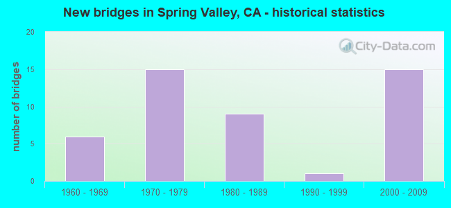
- New bridges - historical statistics
- 61960-1969
- 151970-1979
- 91980-1989
- 11990-1999
- 152000-2009

- Reconstructed bridges - Historical Statistics
- 21980-1989
- 11990-1999
- 22000-2009


- Bridge Condition - Deck
- 53.8%Good
- 38.5%Fair
- 7.7%Poor

- Bridge Condition - Superstructure
- 76.9%Good
- 7.7%Satisfactory
- 15.4%Fair

- Bridge Condition - Substructure
- 84.6%Good
- 15.4%Fair

- Bridge Condition - Channel
- 62.5%Excellent
- 18.8%Good
- 18.8%Satisfactory

- Bridge Condition - Culverts
- 83.3%Good
- 16.7%Satisfactory
Find on map >> Show street view
Structure Number: 14C0048, Location: IN SPRING VALLEY LAKE DEV (Lat: 39.069811, Lng: -122.584442), Route carried "on" structure: County highway , Year Built: 1967, Status: Posted for load, Structure Length: 6.37m (20.90ft), Average Daily Traffic: 15 (year 2016), Average Future Daily Traffic: 28 (year 2038), Features Intersected: NORTH FORK CACHE CREEK, Facility Carried by Structure: CHALK MTN RD
Minimum Vertical Clearance: 30+ m (98+ ft), Kilometerpoint: 0.000, Lanes on structure: 1, Owner: County Highway Agency, Approaching Roadway Width: 5.0m (16.4ft), Material/Design: Steel, Design/Construction: Stringer/Multi-beam, Number Of Spans In Main Unit: 5, Length of Maximum Span: 12.8m (42.0ft), Curb or Sidewalk Widths: Left: 0.4m (1.3ft), Right: 0.4m (1.3ft), Curb-To-Curb Width: 3.3m (10.8ft), Out-to-Out Width: 4.9m (16.1ft)
Condition: Deck: Poor, Superstructure: Satisfactory, Substructure: Good, Channel: Good, Operating Rating: 14.9 metric tons, Method Used To Determine Operating Rating: Load Factor (LF), Inventory Rating: 8.7 metric tons, Method Used To Determine Inventory Rating: Load Factor (LF), Structural Evaluation: High priority of corrective action, Deck Geometry: High priority of replacement, Waterway Adequacy: Better than present minimum criteria, Approach Roadway Alignment: Better than present minimum criteria, Bridge Posting: Required (Relationship of Operating Rating to Maximum Legal Load: > 39.9% below), Designated Inspection Frequency: Every 12 months, Critical Feature Inspection Frequency: Every 24 months, Inspection Date: November 2021, Critical Feature Inspection Date: July 2021, Deck Structure Type: Wood or Timber, Wearing Surface/Protective System: Wearing Surface: Wood or Timber
Find on map >> Show street view
Structure Number: 14C0049, Location: IN SPRING VALLEY LAKE DEV (Lat: 39.082311, Lng: -122.604406), Route carried "on" structure: County highway , Year Built: 1967, Status: Open, Structure Length: 2.56m (8.40ft), Average Daily Traffic: 26 (year 2016), Truck Traffic: 1%, Average Future Daily Traffic: 49 (year 2043), Design Load: H 10, Features Intersected: WOLF CREEK, Facility Carried by Structure: WOLF CREEK ROAD
Minimum Vertical Clearance: 30+ m (98+ ft), Kilometerpoint: 0.000, Lanes on structure: 1, Owner: County Highway Agency, Approaching Roadway Width: 4.3m (14.1ft), Material/Design: Steel, Design/Construction: Stringer/Multi-beam, Number Of Spans In Main Unit: 2, Length of Maximum Span: 12.5m (41.0ft), Curb or Sidewalk Widths: Left: 0.2m (0.7ft), Right: 0.2m (0.7ft), Curb-To-Curb Width: 3.3m (10.8ft), Out-to-Out Width: 3.6m (11.8ft)
Condition: Deck: Fair, Superstructure: Good, Substructure: Good, Channel: Satisfactory, Operating Rating: 27.5 metric tons, Method Used To Determine Operating Rating: Load Factor (LF), Inventory Rating: 16.5 metric tons, Method Used To Determine Inventory Rating: Load Factor (LF), Structural Evaluation: Somewhat better than minimum adequacy, Deck Geometry: High priority of replacement, Waterway Adequacy: Better than present minimum criteria, Approach Roadway Alignment: Better than present minimum criteria, Designated Inspection Frequency: Every 24 months, Critical Feature Inspection Frequency: Every 24 months, Inspection Date: November 2021, Critical Feature Inspection Date: July 2021, Deck Structure Type: Wood or Timber, Wearing Surface/Protective System: Wearing Surface: Other
Find on map >> Show street view
Structure Number: 14C005, Location: IN SPRING VALLEY LAKE DEV (Lat: 39.089758, Lng: -122.607867), Route carried "on" structure: County highway , Year Built: 1967, Year Reconstructed: 2007, Status: Open, Structure Length: 3.78m (12.40ft), Average Daily Traffic: 102 (year 2008), Truck Traffic: 1%, Average Future Daily Traffic: 160 (year 2038), Features Intersected: WOLF CREEK, Facility Carried by Structure: QUAIL TRAIL
Minimum Vertical Clearance: 30+ m (98+ ft), Kilometerpoint: 0.000, Lanes on structure: 2, Owner: County Highway Agency, Approaching Roadway Width: 6.2m (20.3ft), Material/Design: Steel continuous, Design/Construction: Stringer/Multi-beam, Number Of Spans In Main Unit: 3, Length of Maximum Span: 12.5m (41.0ft), Curb or Sidewalk Widths: Left: 0.1m (0.3ft), Right: 0.1m (0.3ft), Curb-To-Curb Width: 5.3m (17.4ft), Out-to-Out Width: 5.5m (18.0ft)
Condition: Deck: Fair, Superstructure: Fair, Substructure: Good, Channel: Good, Operating Rating: 64.2 metric tons, Method Used To Determine Operating Rating: Load Factor (LF), Inventory Rating: 38.6 metric tons, Method Used To Determine Inventory Rating: Load Factor (LF), Structural Evaluation: Somewhat better than minimum adequacy, Deck Geometry: High priority of replacement, Waterway Adequacy: Better than present minimum criteria, Approach Roadway Alignment: Better than present minimum criteria, Designated Inspection Frequency: Every 24 months, Critical Feature Inspection Frequency: Every 24 months, Inspection Date: November 2021, Critical Feature Inspection Date: July 2021, Deck Structure Type: Steel plate, Wearing Surface/Protective System: Wearing Surface: Other
Find on map >> Show street view
Structure Number: 14C0051, Location: IN SPRING VALLEY LAKE DEV (Lat: 39.068767, Lng: -122.585222), Route carried "on" structure: County highway , Year Built: 1967, Year Reconstructed: 2005, Status: Open, Structure Length: 5.05m (16.57ft), Average Daily Traffic: 104 (year 2008), Truck Traffic: 5%, Average Future Daily Traffic: 162 (year 2038), Design Load: HS 20, Features Intersected: WOLF CREEK, Facility Carried by Structure: WOLF CREEK ROAD
Minimum Vertical Clearance: 30+ m (98+ ft), Kilometerpoint: 0.000, Lanes on structure: 1, Owner: County Highway Agency, Approaching Roadway Width: 6.0m (19.7ft), Material/Design: Steel continuous, Design/Construction: Stringer/Multi-beam, Number Of Spans In Main Unit: 4, Length of Maximum Span: 12.5m (41.0ft), Curb-To-Curb Width: 5.3m (17.4ft), Out-to-Out Width: 5.5m (18.0ft)
Condition: Deck: Fair, Superstructure: Fair, Substructure: Fair, Channel: Satisfactory, Operating Rating: 56.1 metric tons, Method Used To Determine Operating Rating: Load Factor (LF), Inventory Rating: 33.7 metric tons, Method Used To Determine Inventory Rating: Load Factor (LF), Structural Evaluation: Somewhat better than minimum adequacy, Deck Geometry: High priority of replacement, Waterway Adequacy: Better than present minimum criteria, Approach Roadway Alignment: Better than present minimum criteria, Designated Inspection Frequency: Every 24 months, Critical Feature Inspection Frequency: Every 24 months, Inspection Date: November 2021, Critical Feature Inspection Date: July 2021, Deck Structure Type: Steel plate, Wearing Surface/Protective System: Wearing Surface: Other
Find on map >> Show street view
Structure Number: 57 0308, Location: 11-SD-125-13.50 (Lat: 32.753111, Lng: -117.011558), Route carried "on" structure: State highway 125, Year Built: 1989, Status: Open, Structure Length: 4.66m (15.29ft), Average Daily Traffic: 183,000 (year 2018), Truck Traffic: 4%, Average Future Daily Traffic: 291,000 (year 2037), Design Load: HS 20, Features Intersected: SPRING STREET
Minimum Vertical Clearance: 30+ m (98+ ft), Kilometerpoint: 13.500, Lanes on structure: 7, Lanes under structure: 5, Base Highway Network: Yes (Inventory Route: 1, Subroute: 1), Owner: State Highway Agency, Approaching Roadway Width: 46.9m (153.9ft), Skew: 30 degrees, Material/Design: Prestressed concrete continuous, Design/Construction: Box Beam or Girders - Multiple, Number Of Spans In Main Unit: 2, Length of Maximum Span: 23.5m (77.1ft), Curb-To-Curb Width: 47.3m (155.2ft), Out-to-Out Width: 49.2m (161.4ft)
Condition: Deck: Good, Superstructure: Good, Substructure: Fair, Operating Rating: 54.1 metric tons, Method Used To Determine Operating Rating: Assigned rating based on Load Factor Design (LFD) reported in metric tons, Inventory Rating: 32.4 metric tons, Method Used To Determine Inventory Rating: Assigned rating based on Load Factor Design (LFD) reported in metric tons, Structural Evaluation: Somewhat better than minimum adequacy, Deck Geometry: Superior to present desirable criteria, Underclear: High priority of corrective action, Approach Roadway Alignment: Equal to present desirable criteria, Designated Inspection Frequency: Every 24 months, Inspection Date: July 2020, Deck Structure Type: Concrete Cast-file-Place
Find on map >> Show street view
Structure Number: 57 0572R, Location: 11-SD-094-R11.80 (Lat: 32.746461, Lng: -116.990056), Route carried "on" structure: State highway 94, Year Built: 1970, Status: Open, Structure Length: 3.96m (12.99ft), Average Daily Traffic: 51,000 (year 2019), Truck Traffic: 6%, Average Future Daily Traffic: 61,414 (year 2041), Design Load: HS 20, Features Intersected: KENWOOD DRIVE
Minimum Vertical Clearance: 30+ m (98+ ft), Kilometerpoint: 11.800, Lanes on structure: 2, Lanes under structure: 4, Base Highway Network: Yes (, Subroute: 1), Owner: State Highway Agency, Approaching Roadway Width: 11.9m (39.0ft), Skew: 1 degrees, Material/Design: Prestressed concrete, Design/Construction: Box Beam or Girders - Multiple, Number Of Spans In Main Unit: 1, Length of Maximum Span: 39.0m (128.0ft), Curb-To-Curb Width: 11.9m (39.0ft), Out-to-Out Width: 12.5m (41.0ft)
Condition: Deck: Good, Superstructure: Good, Substructure: Good, Operating Rating: 50.9 metric tons, Method Used To Determine Operating Rating: Load and Resistance Factor Rating (LRFR) rating reported by rating factor(RF) method using HL-93 loadings, Inventory Rating: 32.4 metric tons, Method Used To Determine Inventory Rating: Load and Resistance Factor Rating (LRFR) rating reported by rating factor(RF) method using HL-93 loadings, Structural Evaluation: Better than present minimum criteria, Deck Geometry: Equal to present minimum criteria, Underclear: Meets minimum limits, Approach Roadway Alignment: Equal to present desirable criteria, Designated Inspection Frequency: Every 24 months, Inspection Date: January 2021, Deck Structure Type: Concrete Cast-file-Place, Wearing Surface/Protective System: Wearing Surface: Bituminous
Find on map >> Show street view
Structure Number: 57 0573R, Location: 11-SD-094-R12.31 (Lat: 32.744375, Lng: -116.981931), Route carried "on" structure: State highway 94, Year Built: 1970, Status: Open, Structure Length: 2.87m (9.42ft), Average Daily Traffic: 51,000 (year 2019), Truck Traffic: 6%, Average Future Daily Traffic: 63,433 (year 2043), Design Load: HS 20, Features Intersected: BARCELONA STREET
Minimum Vertical Clearance: 30+ m (98+ ft), Kilometerpoint: 12.310, Lanes on structure: 2, Lanes under structure: 2, Base Highway Network: Yes (, Subroute: 1), Owner: State Highway Agency, Approaching Roadway Width: 11.9m (39.0ft), Skew: 1 degrees, Material/Design: Prestressed concrete, Design/Construction: Box Beam or Girders - Multiple, Number Of Spans In Main Unit: 1, Length of Maximum Span: 28.0m (91.9ft), Curb-To-Curb Width: 11.9m (39.0ft), Out-to-Out Width: 12.5m (41.0ft)
Condition: Deck: Good, Superstructure: Good, Substructure: Good, Operating Rating: 39.2 metric tons, Method Used To Determine Operating Rating: Load and Resistance Factor Rating (LRFR) rating reported by rating factor(RF) method using HL-93 loadings, Inventory Rating: 27.2 metric tons, Method Used To Determine Inventory Rating: Load and Resistance Factor Rating (LRFR) rating reported by rating factor(RF) method using HL-93 loadings, Structural Evaluation: Equal to present minimum criteria, Deck Geometry: Equal to present minimum criteria, Underclear: Meets minimum limits, Approach Roadway Alignment: Equal to present desirable criteria, Designated Inspection Frequency: Every 24 months, Inspection Date: January 2021, Deck Structure Type: Concrete Cast-file-Place, Wearing Surface/Protective System: Wearing Surface: Bituminous
Find on map >> Show street view
Structure Number: 57 0574, Location: 11-SD-094-R12.73 (Lat: 32.744489, Lng: -116.974408), Route carried "on" structure: City street S268, Year Built: 1970, Status: Open, Structure Length: 9.75m (31.99ft), Average Daily Traffic: 23,500 (year 2019), Truck Traffic: 2%, Average Future Daily Traffic: 42,188 (year 2041), Design Load: HS 20, Features Intersected: STATE ROUTE 94, Facility Carried by Structure: SWEETWATER SPR BLV
Minimum Vertical Clearance: 30+ m (98+ ft), Kilometerpoint: 0.000, Lanes on structure: 5, Lanes under structure: 4, Owner: State Highway Agency, Approaching Roadway Width: 21.9m (71.9ft), Skew: 5 degrees, Material/Design: Prestressed concrete continuous, Design/Construction: Box Beam or Girders - Multiple, Number Of Spans In Main Unit: 2, Length of Maximum Span: 48.5m (159.1ft), Curb or Sidewalk Widths: Left: 1.5m (4.9ft), Right: 0.0m, Curb-To-Curb Width: 21.9m (71.9ft), Out-to-Out Width: 25.9m (85.0ft)
Condition: Deck: Good, Superstructure: Good, Substructure: Good, Operating Rating: 26.6 metric tons, Method Used To Determine Operating Rating: Load and Resistance Factor Rating (LRFR) rating reported by rating factor(RF) method using HL-93 loadings, Inventory Rating: 17.2 metric tons, Method Used To Determine Inventory Rating: Load and Resistance Factor Rating (LRFR) rating reported by rating factor(RF) method using HL-93 loadings, Structural Evaluation: Meets minimum limits, Deck Geometry: Somewhat better than minimum adequacy, Underclear: Meets minimum limits, Approach Roadway Alignment: Equal to present desirable criteria, Designated Inspection Frequency: Every 24 months, Inspection Date: January 2021, Deck Structure Type: Concrete Cast-file-Place
Find on map >> Show street view
Structure Number: 57 0575, Location: 11-SD-094-R13.33 (Lat: 32.744889, Lng: -116.964417), Route carried "on" structure: City street S136, Year Built: 1970, Status: Open, Structure Length: 7.56m (24.80ft), Average Daily Traffic: 25,400 (year 2019), Truck Traffic: 1%, Average Future Daily Traffic: 31,641 (year 2041), Design Load: HS 20, Features Intersected: STATE ROUTE 94, Facility Carried by Structure: AVOCADO BLVD
Minimum Vertical Clearance: 30+ m (98+ ft), Kilometerpoint: 0.000, Lanes on structure: 4, Lanes under structure: 4, Owner: State Highway Agency, Approaching Roadway Width: 25.3m (83.0ft), Skew: 3 degrees, Material/Design: Prestressed concrete continuous, Design/Construction: Box Beam or Girders - Multiple, Number Of Spans In Main Unit: 2, Length of Maximum Span: 38.4m (126.0ft), Curb or Sidewalk Widths: Left: 1.5m (4.9ft), Right: 0.0m, Curb-To-Curb Width: 25.0m (82.0ft), Out-to-Out Width: 27.1m (88.9ft)
Condition: Deck: Fair, Superstructure: Good, Substructure: Good, Operating Rating: 48.6 metric tons, Method Used To Determine Operating Rating: Load and Resistance Factor Rating (LRFR) rating reported by rating factor(RF) method using HL-93 loadings, Inventory Rating: 34.7 metric tons, Method Used To Determine Inventory Rating: Load and Resistance Factor Rating (LRFR) rating reported by rating factor(RF) method using HL-93 loadings, Structural Evaluation: Better than present minimum criteria, Deck Geometry: Superior to present desirable criteria, Underclear: Meets minimum limits, Approach Roadway Alignment: Equal to present desirable criteria, Designated Inspection Frequency: Every 24 months, Inspection Date: January 2021, Deck Structure Type: Concrete Cast-file-Place
Find on map >> Show street view
Structure Number: 57 0799R, Location: 11-SD-094-R10.39R (Lat: 32.752761, Lng: -117.011247), Route carried "on" structure: State highway 94, Year Built: 1976, Status: Open, Structure Length: 5.63m (18.47ft), Average Daily Traffic: 46,500 (year 2019), Truck Traffic: 5%, Average Future Daily Traffic: 67,424 (year 2043), Design Load: HS 20, Features Intersected: SPRING STREET
Minimum Vertical Clearance: 30+ m (98+ ft), Kilometerpoint: 10.390, Lanes on structure: 4, Lanes under structure: 5, Base Highway Network: Yes (, Subroute: 1), Owner: State Highway Agency, Approaching Roadway Width: 27.1m (88.9ft), Skew: 29 degrees, Material/Design: Concrete continuous, Design/Construction: Box Beam or Girders - Multiple, Number Of Spans In Main Unit: 2, Length of Maximum Span: 28.3m (92.8ft), Curb-To-Curb Width: 27.1m (88.9ft), Out-to-Out Width: 30.3m (99.4ft)
Condition: Deck: Good, Superstructure: Good, Substructure: Good, Operating Rating: 98.8 metric tons, Method Used To Determine Operating Rating: Load Factor (LF), Inventory Rating: 59.9 metric tons, Method Used To Determine Inventory Rating: Load Factor (LF), Structural Evaluation: Better than present minimum criteria, Deck Geometry: Superior to present desirable criteria, Underclear: Equal to present minimum criteria, Approach Roadway Alignment: Equal to present desirable criteria, Designated Inspection Frequency: Every 24 months, Inspection Date: January 2021, Deck Structure Type: Concrete Cast-file-Place
Find on map >> Show street view
Structure Number: 57 1056G, Location: 11-SD-125-13.22 (Lat: 32.745236, Lng: -117.017892), Route carried "on" structure: Ramp State highway 125, Year Built: 2003, Status: Open, Structure Length: 39.95m (131.07ft), Average Daily Traffic: 16,300 (year 2012), Truck Traffic: 5%, Average Future Daily Traffic: 18,424 (year 2042), Design Load: HS 20, Features Intersected: SR 125 & SR 94 & CONNS
Minimum Vertical Clearance: 5.30m (17.39ft), Kilometerpoint: 13.220, Lanes on structure: 2, Lanes under structure: 14, Base Highway Network: Yes (Inventory Route: 1, Subroute: 1), Owner: State Highway Agency, Approaching Roadway Width: 11.8m (38.7ft), Skew: 9 degrees, Material/Design: Prestressed concrete continuous, Design/Construction: Box Beam or Girders - Multiple, Number Of Spans In Main Unit: 6, Length of Maximum Span: 80.0m (262.5ft), Curb-To-Curb Width: 11.8m (38.7ft), Out-to-Out Width: 12.8m (42.0ft)
Condition: Deck: Fair, Superstructure: Good, Substructure: Good, Operating Rating: 54.1 metric tons, Method Used To Determine Operating Rating: Assigned rating based on Load Factor Design (LFD) reported in metric tons, Inventory Rating: 32.4 metric tons, Method Used To Determine Inventory Rating: Assigned rating based on Load Factor Design (LFD) reported in metric tons, Structural Evaluation: Better than present minimum criteria, Deck Geometry: Superior to present desirable criteria, Underclear: Meets minimum limits, Approach Roadway Alignment: Equal to present desirable criteria, Designated Inspection Frequency: Every 24 months, Inspection Date: July 2020, Deck Structure Type: Concrete Cast-file-Place
Find on map >> Show street view
Structure Number: 57 1057F, Location: 11-SD-125-13.22 (Lat: 32.743172, Lng: -117.017489), Route carried "on" structure: Bypass State highway 125, Year Built: 2003, Status: Open, Structure Length: 91.20m (299.21ft), Average Daily Traffic: 84,500 (year 2015), Truck Traffic: 5%, Average Future Daily Traffic: 90,984 (year 2042), Design Load: HS 20, Features Intersected: SR-94, CONNS & LOCAL RDS
Minimum Vertical Clearance: 5.43m (17.81ft), Kilometerpoint: 13.220, Lanes on structure: 3, Lanes under structure: 18, Base Highway Network: Yes (Inventory Route: 1, Subroute: 1), Owner: State Highway Agency, Approaching Roadway Width: 16.8m (55.1ft), Skew: 9 degrees, Material/Design: Prestressed concrete continuous, Design/Construction: Box Beam or Girders - Multiple, Number Of Spans In Main Unit: 12, Length of Maximum Span: 88.6m (290.7ft), Curb-To-Curb Width: 16.8m (55.1ft), Out-to-Out Width: 17.8m (58.4ft)
Condition: Deck: Good, Superstructure: Good, Substructure: Good, Operating Rating: 54.1 metric tons, Method Used To Determine Operating Rating: Assigned rating based on Load Factor Design (LFD) reported in metric tons, Inventory Rating: 32.4 metric tons, Method Used To Determine Inventory Rating: Assigned rating based on Load Factor Design (LFD) reported in metric tons, Structural Evaluation: Better than present minimum criteria, Deck Geometry: Equal to present minimum criteria, Underclear: Somewhat better than minimum adequacy, Approach Roadway Alignment: Equal to present desirable criteria, Designated Inspection Frequency: Every 24 months, Inspection Date: July 2020, Deck Structure Type: Concrete Cast-file-Place
Find on map >> Show street view
Structure Number: 57 1059G, Location: 11-SD-125-13.22 (Lat: 32.743828, Lng: -117.017378), Route carried "on" structure: Ramp State highway 125, Year Built: 2003, Status: Open, Structure Length: 39.34m (129.07ft), Average Daily Traffic: 61,200 (year 2016), Truck Traffic: 5%, Average Future Daily Traffic: 90,984 (year 2042), Design Load: HS 20, Features Intersected: BROADWAY & CONNS
Minimum Vertical Clearance: 8.23m (27.00ft), Kilometerpoint: 13.220, Lanes on structure: 2, Lanes under structure: 4, Base Highway Network: Yes (Inventory Route: 1, Subroute: 1), Owner: State Highway Agency, Approaching Roadway Width: 11.7m (38.4ft), Skew: 9 degrees, Material/Design: Prestressed concrete continuous, Design/Construction: Box Beam or Girders - Multiple, Number Of Spans In Main Unit: 6, Length of Maximum Span: 77.0m (252.6ft), Curb-To-Curb Width: 11.7m (38.4ft), Out-to-Out Width: 12.7m (41.7ft)
Condition: Deck: Good, Superstructure: Good, Substructure: Good, Operating Rating: 54.1 metric tons, Method Used To Determine Operating Rating: Assigned rating based on Load Factor Design (LFD) reported in metric tons, Inventory Rating: 32.4 metric tons, Method Used To Determine Inventory Rating: Assigned rating based on Load Factor Design (LFD) reported in metric tons, Structural Evaluation: Better than present minimum criteria, Deck Geometry: Superior to present desirable criteria, Underclear: Somewhat better than minimum adequacy, Approach Roadway Alignment: Equal to present desirable criteria, Designated Inspection Frequency: Every 24 months, Inspection Date: July 2020, Deck Structure Type: Concrete Cast-file-Place
Find on map >> Show street view
Structure Number: 57C0354, Location: 190FT S/O OLIVE DRIVE (Lat: 32.741461, Lng: -117.005469), Route carried "on" structure: County highway , Year Built: 1980, Status: Open, Structure Length: 0.93m (3.05ft), Average Daily Traffic: 13,105 (year 2016), Truck Traffic: 2%, Average Future Daily Traffic: 15,783 (year 2038), Features Intersected: SPRING VALLEY CREEK TRIB, Facility Carried by Structure: BANCROFT DR
Minimum Vertical Clearance: 30+ m (98+ ft), Kilometerpoint: 0.000, Lanes on structure: 2, Owner: County Highway Agency, Approaching Roadway Width: 13.7m (44.9ft), Skew: 6 degrees, Material/Design: Concrete, Design/Construction: Culvert, Number Of Spans In Main Unit: 1, Length of Maximum Span: 9.3m (30.5ft), Curb or Sidewalk Widths: Left: 1.3m (4.3ft), Right: 1.3m (4.3ft), Curb-To-Curb Width: 13.7m (44.9ft), Out-to-Out Width: 16.4m (53.8ft)
Condition: Channel: Excellent, Culverts: Good, Operating Rating: 54.1 metric tons, Method Used To Determine Operating Rating: Field evaluation and documented engineering judgment, Inventory Rating: 32.4 metric tons, Method Used To Determine Inventory Rating: Field evaluation and documented engineering judgment, Structural Evaluation: Better than present minimum criteria, Deck Geometry: Superior to present desirable criteria, Waterway Adequacy: Superior to present desirable criteria, Approach Roadway Alignment: Equal to present desirable criteria, Designated Inspection Frequency: Every 48 months, Inspection Date: May 2021, Deck Structure Type: Concrete Cast-file-Place, Wearing Surface/Protective System: Wearing Surface: Bituminous
Find on map >> Show street view
Structure Number: 57C0405, Location: 0.2 MI E/O BANCROFT DR (Lat: 32.741911, Lng: -117.001094), Route carried "on" structure: City street , Year Built: 1986, Status: Open, Structure Length: 1.16m (3.81ft), Average Daily Traffic: 2,033 (year 2019), Truck Traffic: 5%, Average Future Daily Traffic: 2,609 (year 2041), Features Intersected: CASA DE ORO CREEK, Facility Carried by Structure: OLIVE DR
Minimum Vertical Clearance: 30+ m (98+ ft), Kilometerpoint: 0.000, Lanes on structure: 2, Owner: County Highway Agency, Approaching Roadway Width: 14.0m (45.9ft), Skew: 5 degrees, Material/Design: Concrete continuous, Design/Construction: Culvert, Number Of Spans In Main Unit: 2, Length of Maximum Span: 3.0m (9.8ft), Curb or Sidewalk Widths: Left: 0.0m, Right: 0.2m (0.7ft), Curb-To-Curb Width: 14.0m (45.9ft), Out-to-Out Width: 26.5m (86.9ft)
Condition: Channel: Satisfactory, Culverts: Good, Operating Rating: 54.1 metric tons, Method Used To Determine Operating Rating: Field evaluation and documented engineering judgment, Inventory Rating: 32.4 metric tons, Method Used To Determine Inventory Rating: Field evaluation and documented engineering judgment, Structural Evaluation: Better than present minimum criteria, Deck Geometry: Superior to present desirable criteria, Waterway Adequacy: Equal to present desirable criteria, Approach Roadway Alignment: Equal to present desirable criteria, Designated Inspection Frequency: Every 48 months, Inspection Date: August 2019, Deck Structure Type: Concrete Cast-file-Place, Wearing Surface/Protective System: Wearing Surface: Bituminous
Find on map >> Show street view
Structure Number: 57C0406, Location: 90FT N/O TYLER ST (Lat: 32.730792, Lng: -117.009997), Route carried "on" structure: County highway , Year Built: 1977, Year Reconstructed: 1987, Status: Open, Structure Length: 1.89m (6.20ft), Average Daily Traffic: 1,619 (year 2016), Truck Traffic: 2%, Average Future Daily Traffic: 2,557 (year 2038), Features Intersected: SPRING VALLEY CREEK, Facility Carried by Structure: CENTRAL AVE
Minimum Vertical Clearance: 30+ m (98+ ft), Kilometerpoint: 0.000, Lanes on structure: 2, Owner: County Highway Agency, Approaching Roadway Width: 8.5m (27.9ft), Skew: 5 degrees, Material/Design: Concrete, Design/Construction: Culvert, Number Of Spans In Main Unit: 3, Length of Maximum Span: 5.8m (19.0ft), Curb or Sidewalk Widths: Left: 1.8m (5.9ft), Right: 1.8m (5.9ft), Curb-To-Curb Width: 8.5m (27.9ft), Out-to-Out Width: 12.2m (40.0ft)
Condition: Channel: Excellent, Culverts: Good, Operating Rating: 54.1 metric tons, Method Used To Determine Operating Rating: Field evaluation and documented engineering judgment, Inventory Rating: 32.4 metric tons, Method Used To Determine Inventory Rating: Field evaluation and documented engineering judgment, Structural Evaluation: Better than present minimum criteria, Deck Geometry: Somewhat better than minimum adequacy, Waterway Adequacy: Superior to present desirable criteria, Approach Roadway Alignment: Equal to present desirable criteria, Designated Inspection Frequency: Every 48 months, Inspection Date: May 2021, Deck Structure Type: Concrete Cast-file-Place, Wearing Surface/Protective System: Wearing Surface: Bituminous
Find on map >> Show street view
Structure Number: 57C0411, Location: 0.3 MI SW/O SR 94 (Lat: 32.744592, Lng: -116.994147), Route carried "on" structure: City street , Year Built: 1967, Year Reconstructed: 1998, Status: Open, Structure Length: 1.52m (4.99ft), Average Daily Traffic: 8,350 (year 2019), Truck Traffic: 2%, Average Future Daily Traffic: 9,724 (year 2041), Features Intersected: CASA DE ORO CREEK, Facility Carried by Structure: KENWOOD DR
Minimum Vertical Clearance: 30+ m (98+ ft), Kilometerpoint: 0.000, Lanes on structure: 2, Owner: County Highway Agency, Approaching Roadway Width: 17.0m (55.8ft), Skew: 4 degrees, Material/Design: Concrete continuous, Design/Construction: Culvert, Number Of Spans In Main Unit: 3, Length of Maximum Span: 3.7m (12.1ft), Curb or Sidewalk Widths: Left: 0.0m, Right: 2.9m (9.5ft), Curb-To-Curb Width: 17.0m (55.8ft), Out-to-Out Width: 24.4m (80.1ft)
Condition: Channel: Good, Culverts: Good, Operating Rating: 40.5 metric tons, Method Used To Determine Operating Rating: Field evaluation and documented engineering judgment, Inventory Rating: 24.3 metric tons, Method Used To Determine Inventory Rating: Field evaluation and documented engineering judgment, Structural Evaluation: Equal to present minimum criteria, Deck Geometry: Superior to present desirable criteria, Waterway Adequacy: Superior to present desirable criteria, Approach Roadway Alignment: Equal to present desirable criteria, Designated Inspection Frequency: Every 24 months, Inspection Date: August 2021
Find on map >> Show street view
Structure Number: 57C063, Location: 0.3MI E/O SWEETWATER RD (Lat: 32.738644, Lng: -117.009439), Route carried "on" structure: County highway , Year Built: 1986, Status: Open, Structure Length: 0.79m (2.59ft), Average Daily Traffic: 2,669 (year 2016), Truck Traffic: 1%, Average Future Daily Traffic: 2,800 (year 2038), Features Intersected: SPRING VALLEY CREEK, Facility Carried by Structure: LAMAR ST
Minimum Vertical Clearance: 30+ m (98+ ft), Kilometerpoint: 0.000, Lanes on structure: 2, Owner: County Highway Agency, Approaching Roadway Width: 9.4m (30.8ft), Material/Design: Concrete, Design/Construction: Culvert, Number Of Spans In Main Unit: 2, Length of Maximum Span: 3.7m (12.1ft), Curb or Sidewalk Widths: Left: 0.3m (1.0ft), Right: 0.3m (1.0ft), Curb-To-Curb Width: 14.5m (47.6ft), Out-to-Out Width: 15.1m (49.5ft)
Condition: Channel: Excellent, Culverts: Good, Operating Rating: 54.1 metric tons, Method Used To Determine Operating Rating: Field evaluation and documented engineering judgment, Inventory Rating: 32.4 metric tons, Method Used To Determine Inventory Rating: Field evaluation and documented engineering judgment, Structural Evaluation: Better than present minimum criteria, Deck Geometry: Superior to present desirable criteria, Waterway Adequacy: Superior to present desirable criteria, Approach Roadway Alignment: Equal to present desirable criteria, Designated Inspection Frequency: Every 48 months, Inspection Date: May 2021, Deck Structure Type: Concrete Cast-file-Place, Wearing Surface/Protective System: Wearing Surface: Bituminous
Find on map >> Show street view
Structure Number: 57C0631, Location: 0.33MI E/O SWEETWATER RD (Lat: 32.734556, Lng: -117.008803), Route carried "on" structure: County highway , Year Built: 1983, Status: Open, Structure Length: 1.01m (3.31ft), Average Daily Traffic: 1,223 (year 2016), Truck Traffic: 1%, Average Future Daily Traffic: 1,360 (year 2038), Features Intersected: SPRING VALLEY CREEK, Facility Carried by Structure: VALENCIA ST
Minimum Vertical Clearance: 30+ m (98+ ft), Kilometerpoint: 0.000, Lanes on structure: 2, Owner: County Highway Agency, Approaching Roadway Width: 11.0m (36.1ft), Material/Design: Concrete continuous, Design/Construction: Culvert, Number Of Spans In Main Unit: 3, Length of Maximum Span: 3.0m (9.8ft), Curb or Sidewalk Widths: Left: 0.0m, Right: 1.5m (4.9ft), Curb-To-Curb Width: 11.0m (36.1ft), Out-to-Out Width: 18.2m (59.7ft)
Condition: Channel: Excellent, Culverts: Good, Operating Rating: 54.1 metric tons, Method Used To Determine Operating Rating: Field evaluation and documented engineering judgment, Inventory Rating: 32.4 metric tons, Method Used To Determine Inventory Rating: Field evaluation and documented engineering judgment, Structural Evaluation: Better than present minimum criteria, Deck Geometry: Equal to present minimum criteria, Waterway Adequacy: Superior to present desirable criteria, Approach Roadway Alignment: Equal to present desirable criteria, Designated Inspection Frequency: Every 48 months, Inspection Date: May 2021, Deck Structure Type: Concrete Cast-file-Place, Wearing Surface/Protective System: Wearing Surface: Bituminous
Find on map >> Show street view
Structure Number: 57C0632, Location: 0.35MI E/O SWEETWATER RD (Lat: 32.734561, Lng: -117.008306), Route carried "on" structure: County highway , Year Built: 1983, Status: Open, Structure Length: 0.79m (2.59ft), Average Daily Traffic: 1,223 (year 2016), Average Future Daily Traffic: 1,360 (year 2038), Features Intersected: CASA DE ORO CREEK, Facility Carried by Structure: VALENCIA STREET
Minimum Vertical Clearance: 30+ m (98+ ft), Kilometerpoint: 0.000, Lanes on structure: 2, Owner: County Highway Agency, Approaching Roadway Width: 10.7m (35.1ft), Skew: 1 degrees, Material/Design: Concrete continuous, Design/Construction: Culvert, Number Of Spans In Main Unit: 2, Length of Maximum Span: 3.7m (12.1ft), Curb or Sidewalk Widths: Left: 0.3m (1.0ft), Right: 1.5m (4.9ft), Curb-To-Curb Width: 11.0m (36.1ft), Out-to-Out Width: 18.0m (59.1ft)
Condition: Channel: Excellent, Culverts: Satisfactory, Operating Rating: 54.1 metric tons, Method Used To Determine Operating Rating: Field evaluation and documented engineering judgment, Inventory Rating: 32.4 metric tons, Method Used To Determine Inventory Rating: Field evaluation and documented engineering judgment, Structural Evaluation: Equal to present minimum criteria, Deck Geometry: Equal to present minimum criteria, Waterway Adequacy: Superior to present desirable criteria, Approach Roadway Alignment: Equal to present desirable criteria, Designated Inspection Frequency: Every 48 months, Inspection Date: May 2021, Deck Structure Type: Concrete Cast-file-Place, Wearing Surface/Protective System: Wearing Surface: Bituminous
Find on map >> Show street view
Structure Number: 57C0633, Location: 0.42MI E/O SWEETWATER RD (Lat: 32.736797, Lng: -117.007006), Route carried "on" structure: County highway , Year Built: 1982, Status: Open, Structure Length: 0.98m (3.22ft), Average Daily Traffic: 1,846 (year 2016), Truck Traffic: 1%, Average Future Daily Traffic: 3,741 (year 2038), Features Intersected: CASA DE ORO CREEK, Facility Carried by Structure: TROY STREET
Minimum Vertical Clearance: 30+ m (98+ ft), Kilometerpoint: 0.000, Lanes on structure: 3, Owner: County Highway Agency, Approaching Roadway Width: 14.1m (46.3ft), Skew: 4 degrees, Material/Design: Concrete, Design/Construction: Culvert, Number Of Spans In Main Unit: 2, Length of Maximum Span: 3.7m (12.1ft), Curb-To-Curb Width: 14.1m (46.3ft), Out-to-Out Width: 17.0m (55.8ft)
Condition: Channel: Excellent, Culverts: Good, Operating Rating: 54.1 metric tons, Method Used To Determine Operating Rating: Field evaluation and documented engineering judgment, Inventory Rating: 32.4 metric tons, Method Used To Determine Inventory Rating: Field evaluation and documented engineering judgment, Structural Evaluation: Better than present minimum criteria, Deck Geometry: Somewhat better than minimum adequacy, Waterway Adequacy: Superior to present desirable criteria, Approach Roadway Alignment: Equal to present desirable criteria, Designated Inspection Frequency: Every 48 months, Inspection Date: May 2021, Deck Structure Type: Concrete Cast-file-Place, Wearing Surface/Protective System: Wearing Surface: Bituminous
Find on map >> Show street view
Structure Number: 57C0639, Location: 125 FT E/O BANCROFT DR (Lat: 32.749339, Lng: -117.001283), Route carried "on" structure: City street , Year Built: 1960, Status: Open, Structure Length: 1.25m (4.10ft), Average Daily Traffic: 350 (year 2021), Truck Traffic: 2%, Average Future Daily Traffic: 375 (year 2043), Features Intersected: SPRING VALLEY CREEK, Facility Carried by Structure: HELIX STREET
Minimum Vertical Clearance: 30+ m (98+ ft), Kilometerpoint: 0.000, Lanes on structure: 2, Owner: County Highway Agency, Approaching Roadway Width: 8.8m (28.9ft), Skew: 4 degrees, Material/Design: Concrete continuous, Design/Construction: Culvert, Number Of Spans In Main Unit: 3, Length of Maximum Span: 2.4m (7.9ft), Curb-To-Curb Width: 11.3m (37.1ft), Out-to-Out Width: 11.9m (39.0ft)
Condition: Channel: Excellent, Culverts: Good, Operating Rating: 40.5 metric tons, Method Used To Determine Operating Rating: Field evaluation and documented engineering judgment, Inventory Rating: 24.3 metric tons, Method Used To Determine Inventory Rating: Field evaluation and documented engineering judgment, Structural Evaluation: Equal to present minimum criteria, Deck Geometry: Superior to present desirable criteria, Waterway Adequacy: Equal to present desirable criteria, Approach Roadway Alignment: Equal to present desirable criteria, Designated Inspection Frequency: Every 24 months, Inspection Date: August 2021, Deck Structure Type: Concrete Cast-file-Place, Wearing Surface/Protective System: Wearing Surface: Bituminous
Find on map >> Show street view
Structure Number: 57C0742, Location: 350 FT N/O OLIVE DR. (Lat: 32.743075, Lng: -116.998678), Route carried "on" structure: City street , Year Built: 1983, Status: Open, Structure Length: 0.72m (2.36ft), Average Daily Traffic: 2,624 (year 2016), Truck Traffic: 1%, Average Future Daily Traffic: 2,866 (year 2038), Features Intersected: CASA DE ORO CREEK, Facility Carried by Structure: HELIX STREET
Minimum Vertical Clearance: 30+ m (98+ ft), Kilometerpoint: 0.000, Lanes on structure: 2, Owner: County Highway Agency, Approaching Roadway Width: 15.0m (49.2ft), Skew: 2 degrees, Material/Design: Concrete continuous, Design/Construction: Culvert, Number Of Spans In Main Unit: 2, Length of Maximum Span: 3.3m (10.8ft), Curb or Sidewalk Widths: Left: 1.5m (4.9ft), Right: 1.5m (4.9ft), Curb-To-Curb Width: 15.0m (49.2ft), Out-to-Out Width: 18.0m (59.1ft)
Condition: Channel: Excellent, Culverts: Good, Operating Rating: 54.1 metric tons, Method Used To Determine Operating Rating: Field evaluation and documented engineering judgment, Inventory Rating: 32.4 metric tons, Method Used To Determine Inventory Rating: Field evaluation and documented engineering judgment, Structural Evaluation: Better than present minimum criteria, Deck Geometry: Superior to present desirable criteria, Waterway Adequacy: Equal to present desirable criteria, Approach Roadway Alignment: Equal to present desirable criteria, Designated Inspection Frequency: Every 48 months, Inspection Date: August 2019, Deck Structure Type: Concrete Cast-file-Place, Wearing Surface/Protective System: Wearing Surface: Bituminous
Find on map >> Show street view
Structure Number: 57C0746, Location: 10.0 FT S/O KENWOOD DR. (Lat: 32.744328, Lng: -116.994847), Route carried "on" structure: City street , Year Built: 1998, Status: Open, Structure Length: 0.85m (2.79ft), Average Daily Traffic: 1,057 (year 2016), Truck Traffic: 1%, Average Future Daily Traffic: 1,200 (year 2038), Features Intersected: CASA DE ORO CREEK, Facility Carried by Structure: ALEXANDRA AVENUE
Minimum Vertical Clearance: 30+ m (98+ ft), Kilometerpoint: 0.000, Lanes on structure: 2, Owner: County Highway Agency, Approaching Roadway Width: 12.0m (39.4ft), Material/Design: Concrete continuous, Design/Construction: Culvert, Number Of Spans In Main Unit: 2, Length of Maximum Span: 4.0m (13.1ft), Curb or Sidewalk Widths: Left: 1.5m (4.9ft), Right: 1.5m (4.9ft)
Condition: Channel: Excellent, Culverts: Good, Operating Rating: 54.1 metric tons, Method Used To Determine Operating Rating: Field evaluation and documented engineering judgment, Inventory Rating: 32.4 metric tons, Method Used To Determine Inventory Rating: Field evaluation and documented engineering judgment, Structural Evaluation: Better than present minimum criteria, Waterway Adequacy: Equal to present desirable criteria, Approach Roadway Alignment: Equal to present desirable criteria, Designated Inspection Frequency: Every 48 months, Inspection Date: August 2021
Find on map >> Show street view
Structure Number: 57C0751, Location: 0.3MI E/O SWEETWATER RD (Lat: 32.736600, Lng: -117.009144), Route carried "on" structure: City street , Year Built: 1975, Year Reconstructed: 1993, Status: Open, Structure Length: 0.81m (2.66ft), Average Daily Traffic: 1,846 (year 2016), Truck Traffic: 1%, Average Future Daily Traffic: 3,741 (year 2038), Features Intersected: SPRING VALLEY CREEK, Facility Carried by Structure: TROY STREET
Minimum Vertical Clearance: 30+ m (98+ ft), Kilometerpoint: 0.000, Lanes on structure: 3, Owner: County Highway Agency, Approaching Roadway Width: 13.5m (44.3ft), Skew: 2 degrees, Material/Design: Concrete, Design/Construction: Culvert, Number Of Spans In Main Unit: 2, Length of Maximum Span: 3.7m (12.1ft), Curb or Sidewalk Widths: Left: 1.6m (5.2ft), Right: 1.5m (4.9ft), Curb-To-Curb Width: 13.5m (44.3ft), Out-to-Out Width: 16.9m (55.4ft)
Condition: Channel: Excellent, Culverts: Satisfactory, Operating Rating: 54.1 metric tons, Method Used To Determine Operating Rating: Field evaluation and documented engineering judgment, Inventory Rating: 32.4 metric tons, Method Used To Determine Inventory Rating: Field evaluation and documented engineering judgment, Structural Evaluation: Equal to present minimum criteria, Deck Geometry: Somewhat better than minimum adequacy, Waterway Adequacy: Equal to present desirable criteria, Approach Roadway Alignment: Equal to present desirable criteria, Designated Inspection Frequency: Every 48 months, Inspection Date: May 2021, Deck Structure Type: Concrete Cast-file-Place, Wearing Surface/Protective System: Wearing Surface: Bituminous
Find on map >> Show street view
Structure Number: 57 0308, Location: 11-SD-125-13.50 (Lat: 32.753111, Lng: -117.011558), Route carried "under" structure: County highway S157, Year Built: 1989, Structure Length: 0. m, Average Daily Traffic: 41,910 (year 2015), Truck Traffic: 2%, Features Intersected: SPRING STREET, Facility Carried by Structure: STATE ROUTE 125
Minimum Vertical Clearance: 4.80m (15.75ft), Kilometerpoint: 0.000, Lanes on structure: 7, Lanes under structure: 5, Material/Design: Prestressed concrete continuous, Design/Construction: Box Beam or Girders - Multiple, Length of Maximum Span: 23.5m (77.1ft)
Find on map >> Show street view
Structure Number: 57 0572R, Location: 11-SD-094-R11.80 (Lat: 32.746461, Lng: -116.990056), Route carried "under" structure: County highway , Year Built: 1970, Structure Length: 0. m, Average Daily Traffic: 8,810 (year 2019), Truck Traffic: 2%, Features Intersected: KENWOOD DRIVE, Facility Carried by Structure: STATE ROUTE 94 EB
Minimum Vertical Clearance: 4.95m (16.24ft), Kilometerpoint: 0.000, Lanes on structure: 2, Lanes under structure: 4, Material/Design: Prestressed concrete, Design/Construction: Box Beam or Girders - Multiple, Length of Maximum Span: 39.0m (128.0ft)
Find on map >> Show street view
Structure Number: 57 0573R, Location: 11-SD-094-R12.31 (Lat: 32.744375, Lng: -116.981931), Route carried "under" structure: County highway , Year Built: 1970, Structure Length: 0. m, Average Daily Traffic: 4,940 (year 2019), Truck Traffic: 2%, Features Intersected: BARCELONA STREET, Facility Carried by Structure: STATE ROUTE 94 EB
Minimum Vertical Clearance: 4.60m (15.09ft), Kilometerpoint: 0.000, Lanes on structure: 2, Lanes under structure: 2, Material/Design: Prestressed concrete, Design/Construction: Box Beam or Girders - Multiple, Length of Maximum Span: 28.0m (91.9ft)
Find on map >> Show street view
Structure Number: 57 0574, Location: 11-SD-094-R12.73 (Lat: 32.744489, Lng: -116.974408), Route carried "under" structure: State highway 94, Year Built: 1970, Structure Length: 0. m, Average Daily Traffic: 68,000 (year 2019), Truck Traffic: 5%, Features Intersected: STATE ROUTE 94, Facility Carried by Structure: SWEETWATER SPR BLV
Minimum Vertical Clearance: 4.80m (15.75ft), Kilometerpoint: 12.730, Lanes on structure: 5, Lanes under structure: 4, Material/Design: Prestressed concrete continuous, Design/Construction: Box Beam or Girders - Multiple, Length of Maximum Span: 48.5m (159.1ft)
Find on map >> Show street view
Structure Number: 57 0575, Location: 11-SD-094-R13.33 (Lat: 32.744889, Lng: -116.964417), Route carried "under" structure: State highway 94, Year Built: 1970, Structure Length: 0. m, Average Daily Traffic: 63,000 (year 2019), Truck Traffic: 6%, Features Intersected: STATE ROUTE 94, Facility Carried by Structure: AVOCADO BLVD
Minimum Vertical Clearance: 5.46m (17.91ft), Kilometerpoint: 13.330, Lanes on structure: 4, Lanes under structure: 4, Material/Design: Prestressed concrete continuous, Design/Construction: Box Beam or Girders - Multiple, Length of Maximum Span: 38.4m (126.0ft)
Find on map >> Show street view
Structure Number: 57 0799R, Location: 11-SD-094-R10.39R (Lat: 32.752761, Lng: -117.011247), Route carried "under" structure: County highway S157, Year Built: 1976, Structure Length: 0. m, Average Daily Traffic: 39,100 (year 2020), Truck Traffic: 2%, Features Intersected: SPRING STREET, Facility Carried by Structure: STATE ROUTE 94 EB
Minimum Vertical Clearance: 4.54m (14.90ft), Kilometerpoint: 0.000, Lanes on structure: 4, Lanes under structure: 5, Material/Design: Concrete continuous, Design/Construction: Box Beam or Girders - Multiple, Length of Maximum Span: 28.3m (92.8ft)
Find on map >> Show street view
Structure Number: 57 0801L, Location: 11-SD-094-M10.25L (Lat: 32.753947, Lng: -117.010836), Route carried "under" structure: City street , Year Built: 1976, Structure Length: 0. m, Average Daily Traffic: 25,000 (year 2018), Truck Traffic: 3%, Features Intersected: SR 125,CAMPO-N125,SPRING, Facility Carried by Structure: STATE ROUTE 94 WB
Minimum Vertical Clearance: 11.35m (37.24ft), Kilometerpoint: 0.000, Lanes on structure: 3, Lanes under structure: 6, Material/Design: Prestressed concrete continuous, Design/Construction: Box Beam or Girders - Multiple, Length of Maximum Span: 65.2m (213.9ft)
Find on map >> Show street view
Structure Number: 57 0801L, Location: 11-SD-094-M10.25L (Lat: 32.753947, Lng: -117.010836), Route carried "under" structure: Ramp State highway 125, Year Built: 1976, Structure Length: 0. m, Average Daily Traffic: 39,000 (year 2020), Truck Traffic: 1%, Features Intersected: SR 125,CAMPO-N125,SPRING, Facility Carried by Structure: STATE ROUTE 94 WB
Minimum Vertical Clearance: 9.14m (29.99ft), Kilometerpoint: 13.640, Lanes on structure: 3, Lanes under structure: 2, Material/Design: Prestressed concrete continuous, Design/Construction: Box Beam or Girders - Multiple, Length of Maximum Span: 65.2m (213.9ft)
Find on map >> Show street view
Structure Number: 57 0801L, Location: 11-SD-094-M10.25L (Lat: 32.753947, Lng: -117.010836), Route carried "under" structure: State highway 125, Year Built: 1976, Structure Length: 0. m, Average Daily Traffic: 164,000 (year 2020), Truck Traffic: 4%, Features Intersected: SR 125,CAMPO-N125,SPRING, Facility Carried by Structure: STATE ROUTE 94 WB
Minimum Vertical Clearance: 5.79m (19.00ft), Kilometerpoint: 13.550, Lanes on structure: 3, Lanes under structure: 7, Material/Design: Prestressed concrete continuous, Design/Construction: Box Beam or Girders - Multiple, Length of Maximum Span: 65.2m (213.9ft)
Find on map >> Show street view
Structure Number: 57 1056G, Location: 11-SD-125-13.22 (Lat: 32.745236, Lng: -117.017892), Route carried "under" structure: Ramp State highway 125, Year Built: 2003, Structure Length: 0. m, Average Daily Traffic: 8,400 (year 2016), Truck Traffic: 5%, Features Intersected: SR 125 & SR 94 & CONNS
Minimum Vertical Clearance: 7.93m (26.02ft), Kilometerpoint: 13.220, Lanes on structure: 2, Lanes under structure: 2, Material/Design: Prestressed concrete continuous, Design/Construction: Box Beam or Girders - Multiple, Length of Maximum Span: 80.0m (262.5ft)
Find on map >> Show street view
Structure Number: 57 1056G, Location: 11-SD-125-13.22 (Lat: 32.745236, Lng: -117.017892), Route carried "under" structure: State highway 94, Year Built: 2003, Structure Length: 0. m, Average Daily Traffic: 144,000 (year 2018), Truck Traffic: 5%, Features Intersected: SR 125 & SR 94 & CONNS
Minimum Vertical Clearance: 5.67m (18.60ft), Kilometerpoint: 9.660, Lanes on structure: 2, Lanes under structure: 6, Material/Design: Prestressed concrete continuous, Design/Construction: Box Beam or Girders - Multiple, Length of Maximum Span: 80.0m (262.5ft)
Find on map >> Show street view
Structure Number: 57 1056G, Location: 11-SD-125-13.22 (Lat: 32.745236, Lng: -117.017892), Route carried "under" structure: Ramp State highway 94, Year Built: 2003, Structure Length: 0. m, Average Daily Traffic: 72,000 (year 2018), Truck Traffic: 5%, Features Intersected: SR 125 & SR 94 & CONNS
Minimum Vertical Clearance: 5.58m (18.31ft), Kilometerpoint: 9.690, Lanes on structure: 2, Lanes under structure: 2, Material/Design: Prestressed concrete continuous, Design/Construction: Box Beam or Girders - Multiple, Length of Maximum Span: 80.0m (262.5ft)
Find on map >> Show street view
Structure Number: 57 1056G, Location: 11-SD-125-13.22 (Lat: 32.745236, Lng: -117.017892), Route carried "under" structure: City street , Year Built: 2003, Structure Length: 0. m, Average Daily Traffic: 27,500 (year 2015), Truck Traffic: 5%, Features Intersected: SR 125 & SR 94 & CONNS, Facility Carried by Structure: N125-W94 CONNECTOR
Minimum Vertical Clearance: 22.34m (73.29ft), Kilometerpoint: 0.000, Lanes on structure: 2, Lanes under structure: 4, Material/Design: Prestressed concrete continuous, Design/Construction: Box Beam or Girders - Multiple, Length of Maximum Span: 80.0m (262.5ft)
Find on map >> Show street view
Structure Number: 57 1057F, Location: 11-SD-125-13.22 (Lat: 32.743172, Lng: -117.017489), Route carried "under" structure: Ramp State highway 94, Year Built: 2003, Structure Length: 0. m, Average Daily Traffic: 72,000 (year 2018), Truck Traffic: 5%, Features Intersected: SR-94, CONNS & LOCAL RDS, Facility Carried by Structure: S125
Minimum Vertical Clearance: 13.60m (44.62ft), Kilometerpoint: 9.700, Lanes on structure: 3, Lanes under structure: 2, Material/Design: Prestressed concrete continuous, Design/Construction: Box Beam or Girders - Multiple, Length of Maximum Span: 88.6m (290.7ft)
Find on map >> Show street view
Structure Number: 57 1057F, Location: 11-SD-125-13.22 (Lat: 32.743172, Lng: -117.017489), Route carried "under" structure: State highway 94, Year Built: 2003, Structure Length: 0. m, Average Daily Traffic: 144,000 (year 2018), Truck Traffic: 5%, Features Intersected: SR-94, CONNS & LOCAL RDS, Facility Carried by Structure: S125
Minimum Vertical Clearance: 15.92m (52.23ft), Kilometerpoint: 9.750, Lanes on structure: 3, Lanes under structure: 6, Material/Design: Prestressed concrete continuous, Design/Construction: Box Beam or Girders - Multiple, Length of Maximum Span: 88.6m (290.7ft)
Find on map >> Show street view
Structure Number: 57 1057F, Location: 11-SD-125-13.22 (Lat: 32.743172, Lng: -117.017489), Route carried "under" structure: Ramp State highway 125, Year Built: 2003, Structure Length: 0. m, Average Daily Traffic: 18,000 (year 2016), Truck Traffic: 5%, Features Intersected: SR-94, CONNS & LOCAL RDS
Minimum Vertical Clearance: 5.31m (17.42ft), Kilometerpoint: 13.220, Lanes on structure: 3, Lanes under structure: 2, Material/Design: Prestressed concrete continuous, Design/Construction: Box Beam or Girders - Multiple, Length of Maximum Span: 88.6m (290.7ft)
Find on map >> Show street view
Structure Number: 57 1057F, Location: 11-SD-125-13.22 (Lat: 32.743172, Lng: -117.017489), Route carried "under" structure: City street , Year Built: 2003, Structure Length: 0. m, Average Daily Traffic: 28,200 (year 2015), Truck Traffic: 5%, Features Intersected: SR-94, CONNS & LOCAL RDS, Facility Carried by Structure: S125
Minimum Vertical Clearance: 19.70m (64.63ft), Kilometerpoint: 0.000, Lanes on structure: 3, Lanes under structure: 4, Material/Design: Prestressed concrete continuous, Design/Construction: Box Beam or Girders - Multiple, Length of Maximum Span: 88.6m (290.7ft)
Find on map >> Show street view
Structure Number: 57 1057F, Location: 11-SD-125-13.22 (Lat: 32.743172, Lng: -117.017489), Route carried "under" structure: City street , Year Built: 2003, Structure Length: 0. m, Average Daily Traffic: 27,500 (year 2015), Truck Traffic: 5%, Features Intersected: SR-94, CONNS & LOCAL RDS, Facility Carried by Structure: S125
Minimum Vertical Clearance: 32.65m (107.12ft), Kilometerpoint: 0.000, Lanes on structure: 3, Lanes under structure: 4, Material/Design: Prestressed concrete continuous, Design/Construction: Box Beam or Girders - Multiple, Length of Maximum Span: 88.6m (290.7ft)
Find on map >> Show street view
Structure Number: 57 1059G, Location: 11-SD-125-13.22 (Lat: 32.743828, Lng: -117.017378), Route carried "under" structure: City street , Year Built: 2003, Structure Length: 0. m, Average Daily Traffic: 27,500 (year 2015), Truck Traffic: 5%, Features Intersected: BROADWAY & CONNS, Facility Carried by Structure: 125N CONNECTOR
Minimum Vertical Clearance: 6.52m (21.39ft), Kilometerpoint: 0.000, Lanes on structure: 2, Lanes under structure: 4, Material/Design: Prestressed concrete continuous, Design/Construction: Box Beam or Girders - Multiple, Length of Maximum Span: 77.0m (252.6ft)
Find on map >> Show street view
Structure Number: 57 1060G, Location: 11-SD-125-13.22 (Lat: 32.742567, Lng: -117.016544), Route carried "under" structure: City street , Year Built: 2003, Structure Length: 0. m, Average Daily Traffic: 27,500 (year 2015), Truck Traffic: 5%, Features Intersected: SWEETWATER RD & BROADWAY, Facility Carried by Structure: N125 TO E94
Minimum Vertical Clearance: 16.94m (55.58ft), Kilometerpoint: 0.000, Lanes on structure: 2, Lanes under structure: 4, Material/Design: Prestressed concrete continuous, Design/Construction: Box Beam or Girders - Multiple, Length of Maximum Span: 80.0m (262.5ft)
Find on map >> Show street view
Structure Number: 57 1060G, Location: 11-SD-125-13.22 (Lat: 32.742567, Lng: -117.016544), Route carried "under" structure: City street , Year Built: 2003, Structure Length: 0. m, Average Daily Traffic: 28,200 (year 2015), Truck Traffic: 5%, Features Intersected: SWEETWATER RD & BROADWAY, Facility Carried by Structure: N125 TO E94
Minimum Vertical Clearance: 6.70m (21.98ft), Kilometerpoint: 0.000, Lanes on structure: 2, Lanes under structure: 4, Material/Design: Prestressed concrete continuous, Design/Construction: Box Beam or Girders - Multiple, Length of Maximum Span: 80.0m (262.5ft)