Bridge Statistics for Slaton, Texas (TX)
Condition, Traffic, Stress, Structural Evaluation, Project Costs
- National Bridge Inventory (NBI) Statistics
- 15Number of bridges
- 157ft / 48.0mTotal length
- 69,719Total average daily traffic
- 16,736Total average daily truck traffic
- National Bridge Inventory (NBI) Registered Bridges for Slaton
- No street view available for this location
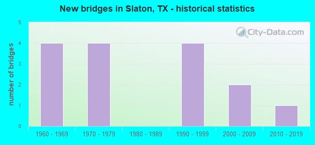
- New bridges - historical statistics
- 41960-1969
- 41970-1979
- 41990-1999
- 22000-2009
- 12010-2019


- Bridge Condition - Deck
- 50.0%Good
- 50.0%Satisfactory

- Bridge Condition - Superstructure
- 12.5%Very good
- 37.5%Good
- 50.0%Satisfactory

- Bridge Condition - Substructure
- 75.0%Good
- 25.0%Satisfactory
Find on map >> Show street view
Structure Number: 51520005301073, Location: 1.60 MI SE OF FM 41 (Lat: 33.420033, Lng: -101.642864), Route carried "on" structure: US 84, Year Built: 1966, Status: Open, Structure Length: 5.55m (18.21ft), Average Daily Traffic: 11,658 (year 2018), Truck Traffic: 28%, Average Future Daily Traffic: 6,870 (year 2033), Design Load: H 20, Features Intersected: FM 400
Minimum Vertical Clearance: 30+ m (98+ ft), Kilometerpoint: 59.443, Lanes on structure: 2, Lanes under structure: 4, Base Highway Network: Yes, Owner: State Highway Agency, Approaching Roadway Width: 11.6m (38.1ft), Skew: 3 degrees, Material/Design: Prestressed concrete, Design/Construction: Stringer/Multi-beam, Number Of Spans In Main Unit: 2, Number Of Approach Spans: 2, Length of Maximum Span: 16.2m (53.1ft), Curb-To-Curb Width: 12.0m (39.4ft), Out-to-Out Width: 12.9m (42.3ft)
Condition: Deck: Satisfactory, Superstructure: Satisfactory, Substructure: Satisfactory, Operating Rating: 54.4 metric tons, Method Used To Determine Operating Rating: Load Factor (LF), Inventory Rating: 23.6 metric tons, Method Used To Determine Inventory Rating: Load Factor (LF), Structural Evaluation: Somewhat better than minimum adequacy, Deck Geometry: Better than present minimum criteria, Underclear: High priority of corrective action, Approach Roadway Alignment: Equal to present desirable criteria, Designated Inspection Frequency: Every 24 months, Inspection Date: October 2021, Deck Structure Type: Concrete Cast-file-Place, Wearing Surface/Protective System: Wearing Surface: Bituminous
Find on map >> Show street view
Structure Number: 51520005301074, Location: 1.60 MI SE OF FM 41 (Lat: 33.420253, Lng: -101.642872), Route carried "on" structure: US 84, Year Built: 1966, Status: Open, Structure Length: 5.55m (18.21ft), Average Daily Traffic: 5,338 (year 2020), Truck Traffic: 28%, Average Future Daily Traffic: 6,870 (year 2033), Design Load: H 20, Features Intersected: FM 400
Minimum Vertical Clearance: 30+ m (98+ ft), Kilometerpoint: 59.404, Lanes on structure: 2, Lanes under structure: 4, Owner: State Highway Agency, Approaching Roadway Width: 11.6m (38.1ft), Skew: 3 degrees, Material/Design: Prestressed concrete, Design/Construction: Stringer/Multi-beam, Number Of Spans In Main Unit: 2, Number Of Approach Spans: 2, Length of Maximum Span: 16.2m (53.1ft), Curb-To-Curb Width: 12.0m (39.4ft), Out-to-Out Width: 12.9m (42.3ft)
Condition: Deck: Satisfactory, Superstructure: Satisfactory, Substructure: Satisfactory, Operating Rating: 54.4 metric tons, Method Used To Determine Operating Rating: Load Factor (LF), Inventory Rating: 23.6 metric tons, Method Used To Determine Inventory Rating: Load Factor (LF), Structural Evaluation: Somewhat better than minimum adequacy, Deck Geometry: Better than present minimum criteria, Underclear: High priority of corrective action, Approach Roadway Alignment: Equal to present desirable criteria, Designated Inspection Frequency: Every 24 months, Inspection Date: October 2021, Deck Structure Type: Concrete Cast-file-Place, Wearing Surface/Protective System: Wearing Surface: Bituminous
Find on map >> Show street view
Structure Number: 51520005301075, Location: 1.60 MI NW OF FM 400 (Lat: 33.433839, Lng: -101.664097), Route carried "on" structure: US 84, Year Built: 1970, Status: Open, Structure Length: 5.73m (18.80ft), Average Daily Traffic: 6,801 (year 2020), Truck Traffic: 27%, Average Future Daily Traffic: 9,522 (year 2040), Design Load: HS 20, Features Intersected: FM 41
Minimum Vertical Clearance: 30+ m (98+ ft), Kilometerpoint: 56.885, Lanes on structure: 2, Lanes under structure: 4, Base Highway Network: Yes, Owner: State Highway Agency, Approaching Roadway Width: 12.8m (42.0ft), Skew: 2 degrees, Material/Design: Prestressed concrete, Design/Construction: Stringer/Multi-beam, Number Of Spans In Main Unit: 2, Length of Maximum Span: 28.7m (94.2ft), Curb-To-Curb Width: 12.6m (41.3ft), Out-to-Out Width: 13.5m (44.3ft)
Condition: Deck: Satisfactory, Superstructure: Satisfactory, Substructure: Good, Operating Rating: 68.0 metric tons, Method Used To Determine Operating Rating: Load Factor (LF), Inventory Rating: 26.3 metric tons, Method Used To Determine Inventory Rating: Load Factor (LF), Structural Evaluation: Equal to present minimum criteria, Deck Geometry: Better than present minimum criteria, Underclear: Better than present minimum criteria, Approach Roadway Alignment: Equal to present desirable criteria, Designated Inspection Frequency: Every 24 months, Inspection Date: October 2021, Deck Structure Type: Concrete Cast-file-Place, Wearing Surface/Protective System: Wearing Surface: Bituminous
Find on map >> Show street view
Structure Number: 51520005301076, Location: 1.60 MI NW OF FM 400 (Lat: 33.433903, Lng: -101.663894), Route carried "on" structure: US 84, Year Built: 1970, Status: Open, Structure Length: 5.73m (18.80ft), Average Daily Traffic: 6,801 (year 2020), Truck Traffic: 27%, Average Future Daily Traffic: 9,522 (year 2040), Design Load: HS 20, Features Intersected: FM 41
Minimum Vertical Clearance: 30+ m (98+ ft), Kilometerpoint: 56.921, Lanes on structure: 2, Lanes under structure: 4, Base Highway Network: Yes, Owner: State Highway Agency, Approaching Roadway Width: 12.8m (42.0ft), Skew: 2 degrees, Material/Design: Prestressed concrete, Design/Construction: Stringer/Multi-beam, Number Of Spans In Main Unit: 2, Length of Maximum Span: 28.7m (94.2ft), Curb-To-Curb Width: 12.6m (41.3ft), Out-to-Out Width: 13.5m (44.3ft)
Condition: Deck: Satisfactory, Superstructure: Satisfactory, Substructure: Good, Operating Rating: 68.0 metric tons, Method Used To Determine Operating Rating: Load Factor (LF), Inventory Rating: 26.3 metric tons, Method Used To Determine Inventory Rating: Load Factor (LF), Structural Evaluation: Equal to present minimum criteria, Deck Geometry: Better than present minimum criteria, Underclear: Better than present minimum criteria, Approach Roadway Alignment: Equal to present desirable criteria, Designated Inspection Frequency: Every 24 months, Inspection Date: October 2021, Deck Structure Type: Concrete Cast-file-Place, Wearing Surface/Protective System: Wearing Surface: Bituminous
Find on map >> Show street view
Structure Number: 51520005301089, Location: 1.00 MI N OF FM 41 (Lat: 33.448325, Lng: -101.665958), Route carried "on" structure: US 84, Year Built: 1990, Status: Open, Structure Length: 4.27m (14.01ft), Average Daily Traffic: 5,600 (year 2013), Truck Traffic: 28%, Average Future Daily Traffic: 7,840 (year 2033), Design Load: HS 20, Features Intersected: WOODROW ROAD
Minimum Vertical Clearance: 30+ m (98+ ft), Kilometerpoint: 55.262, Lanes on structure: 2, Lanes under structure: 4, Owner: State Highway Agency, Approaching Roadway Width: 11.6m (38.1ft), Material/Design: Prestressed concrete, Design/Construction: Stringer/Multi-beam, Number Of Spans In Main Unit: 1, Number Of Approach Spans: 2, Length of Maximum Span: 24.4m (80.1ft), Curb-To-Curb Width: 11.3m (37.1ft), Out-to-Out Width: 12.2m (40.0ft)
Condition: Deck: Good, Superstructure: Very good, Substructure: Good, Operating Rating: 54.4 metric tons, Method Used To Determine Operating Rating: Assigned rating based on Load Factor Design (LFD) reported in metric tons, Inventory Rating: 32.7 metric tons, Method Used To Determine Inventory Rating: Assigned rating based on Load Factor Design (LFD) reported in metric tons, Structural Evaluation: Better than present minimum criteria, Deck Geometry: Equal to present minimum criteria, Underclear: Meets minimum limits, Approach Roadway Alignment: Equal to present desirable criteria, Designated Inspection Frequency: Every 24 months, Inspection Date: October 2021, Deck Structure Type: Concrete Cast-file-Place, Wearing Surface/Protective System: Wearing Surface: Bituminous, Deck Protection: Epoxy Coated Reinforcing
Find on map >> Show street view
Structure Number: 5152000530109, Location: 1.00 MI N OF FM 41 (Lat: 33.448322, Lng: -101.666172), Route carried "on" structure: US 84, Year Built: 1990, Status: Open, Structure Length: 4.27m (14.01ft), Average Daily Traffic: 5,600 (year 2013), Truck Traffic: 28%, Average Future Daily Traffic: 7,840 (year 2033), Design Load: HS 20, Features Intersected: WOODROW ROAD
Minimum Vertical Clearance: 30+ m (98+ ft), Kilometerpoint: 55.262, Lanes on structure: 2, Lanes under structure: 4, Owner: State Highway Agency, Approaching Roadway Width: 11.6m (38.1ft), Material/Design: Prestressed concrete, Design/Construction: Stringer/Multi-beam, Number Of Spans In Main Unit: 1, Number Of Approach Spans: 2, Length of Maximum Span: 24.4m (80.1ft), Curb-To-Curb Width: 11.4m (37.4ft), Out-to-Out Width: 12.3m (40.4ft)
Condition: Deck: Good, Superstructure: Good, Substructure: Good, Operating Rating: 54.4 metric tons, Method Used To Determine Operating Rating: Assigned rating based on Load Factor Design (LFD) reported in metric tons, Inventory Rating: 32.7 metric tons, Method Used To Determine Inventory Rating: Assigned rating based on Load Factor Design (LFD) reported in metric tons, Structural Evaluation: Better than present minimum criteria, Deck Geometry: Equal to present minimum criteria, Underclear: Meets minimum limits, Approach Roadway Alignment: Equal to present desirable criteria, Designated Inspection Frequency: Every 24 months, Inspection Date: October 2021, Deck Structure Type: Concrete Cast-file-Place, Wearing Surface/Protective System: Wearing Surface: Bituminous, Deck Protection: Epoxy Coated Reinforcing
Find on map >> Show street view
Structure Number: 51520005301188, Location: 1.70 MI N OF FM 41 (Lat: 33.458022, Lng: -101.667381), Route carried "on" structure: Business State highway 84, Year Built: 2009, Status: Open, Structure Length: 6.95m (22.80ft), Average Daily Traffic: 1,800 (year 2015), Truck Traffic: 7%, Average Future Daily Traffic: 2,520 (year 2035), Design Load: HL 93, Features Intersected: US 84 WB
Minimum Vertical Clearance: 30+ m (98+ ft), Kilometerpoint: 1.951, Lanes on structure: 2, Lanes under structure: 2, Owner: State Highway Agency, Approaching Roadway Width: 11.6m (38.1ft), Skew: 6 degrees, Material/Design: Prestressed concrete, Design/Construction: Stringer/Multi-beam, Number Of Spans In Main Unit: 3, Length of Maximum Span: 27.4m (89.9ft), Curb-To-Curb Width: 11.4m (37.4ft), Out-to-Out Width: 12.3m (40.4ft)
Condition: Deck: Good, Superstructure: Good, Substructure: Good, Operating Rating: 54.4 metric tons, Method Used To Determine Operating Rating: Assigned ratings based on Load and Resistance Factor Design (LRFD) reported in metric tons, Inventory Rating: 32.7 metric tons, Method Used To Determine Inventory Rating: Assigned ratings based on Load and Resistance Factor Design (LRFD) reported in metric tons, Structural Evaluation: Better than present minimum criteria, Deck Geometry: Equal to present minimum criteria, Underclear: Equal to present minimum criteria, Approach Roadway Alignment: Equal to present desirable criteria, Designated Inspection Frequency: Every 24 months, Inspection Date: October 2021, Deck Structure Type: Concrete Cast-file-Place, Wearing Surface/Protective System: Wearing Surface: Low Slump Concrete, Deck Protection: Epoxy Coated Reinforcing
Find on map >> Show street view
Structure Number: 51520005301191, Location: 14.0 MI SE OF LOOP 289 (Lat: 33.415050, Lng: -101.634439), Route carried "on" structure: US 84, Year Built: 2017, Status: Open, Structure Length: 9.91m (32.51ft), Average Daily Traffic: 11,781 (year 2020), Truck Traffic: 21%, Average Future Daily Traffic: 20,410 (year 2035), Design Load: HL 93, Features Intersected: SPLR
Minimum Vertical Clearance: 30+ m (98+ ft), Kilometerpoint: 60.405, Lanes on structure: 4, Lanes under structure: 2, Base Highway Network: Yes, Owner: State Highway Agency, Approaching Roadway Width: 23.2m (76.1ft), Skew: 30 degrees, Material/Design: Prestressed concrete, Design/Construction: Stringer/Multi-beam, Number Of Spans In Main Unit: 3, Length of Maximum Span: 35.1m (115.2ft), Curb-To-Curb Width: 22.9m (75.1ft), Out-to-Out Width: 24.4m (80.1ft)
Condition: Deck: Good, Superstructure: Good, Substructure: Good, Operating Rating: 54.4 metric tons, Method Used To Determine Operating Rating: Assigned ratings based on Load and Resistance Factor Design (LRFD) reported in metric tons, Inventory Rating: 32.7 metric tons, Method Used To Determine Inventory Rating: Assigned ratings based on Load and Resistance Factor Design (LRFD) reported in metric tons, Structural Evaluation: Better than present minimum criteria, Deck Geometry: Superior to present desirable criteria, Underclear: Superior to present desirable criteria, Approach Roadway Alignment: Equal to present desirable criteria, Designated Inspection Frequency: Every 24 months, Inspection Date: July 2021, Deck Structure Type: Concrete Cast-file-Place
Find on map >> Show street view
Structure Number: 51520005301073, Location: 1.60 MI SE OF FM 41 (Lat: 33.420000, Lng: -101.642800), Route carried "under" structure: State highway 400, Year Built: 1966, Structure Length: 0. m, Average Daily Traffic: 3,300 (year 2013), Truck Traffic: 11%, Features Intersected: FM 400, Facility Carried by Structure: US 84 EB
Minimum Vertical Clearance: 4.88m (16.01ft), Kilometerpoint: 0.418, Lanes on structure: 4, Material/Design: Prestressed concrete, Design/Construction: Stringer/Multi-beam, Length of Maximum Span: 16.2m (53.1ft)
Find on map >> Show street view
Structure Number: 51520005301074, Location: 1.60 MI SE OF FM 41 (Lat: 33.420200, Lng: -101.642900), Route carried "under" structure: State highway 400, Year Built: 1966, Structure Length: 0. m, Average Daily Traffic: 3,300 (year 2013), Truck Traffic: 11%, Features Intersected: FM 400, Facility Carried by Structure: US 84 WB
Minimum Vertical Clearance: 4.83m (15.85ft), Kilometerpoint: 0.354, Lanes on structure: 4, Material/Design: Prestressed concrete, Design/Construction: Stringer/Multi-beam, Length of Maximum Span: 16.2m (53.1ft)
Find on map >> Show street view
Structure Number: 51520005301075, Location: 1.60 MI NW OF FM 400 (Lat: 33.433800, Lng: -101.664100), Route carried "under" structure: State highway 41, Year Built: 1970, Structure Length: 0. m, Average Daily Traffic: 1,120 (year 2013), Truck Traffic: 10%, Features Intersected: FM 41, Facility Carried by Structure: US 84 EB
Minimum Vertical Clearance: 4.90m (16.08ft), Kilometerpoint: 18.293, Lanes on structure: 4, Material/Design: Prestressed concrete, Design/Construction: Stringer/Multi-beam, Length of Maximum Span: 28.7m (94.2ft)
Find on map >> Show street view
Structure Number: 51520005301076, Location: 1.60 MI NW OF FM 400 (Lat: 33.433900, Lng: -101.663900), Route carried "under" structure: State highway 41, Year Built: 1970, Structure Length: 0. m, Average Daily Traffic: 1,120 (year 2013), Truck Traffic: 10%, Features Intersected: FM 41, Facility Carried by Structure: US 84 WB
Minimum Vertical Clearance: 4.93m (16.17ft), Kilometerpoint: 18.310, Lanes on structure: 4, Material/Design: Prestressed concrete, Design/Construction: Stringer/Multi-beam, Length of Maximum Span: 28.7m (94.2ft)
Find on map >> Show street view
Structure Number: 51520005301089, Location: 1.00 MI N OF FM 41 (Lat: 33.448300, Lng: -101.665950), Route carried "under" structure: City street , Year Built: 1990, Structure Length: 0. m, Average Daily Traffic: 100 (year 2010), Truck Traffic: 15%, Features Intersected: WOODROW ROAD, Facility Carried by Structure: US 84 WB
Minimum Vertical Clearance: 5.28m (17.32ft), Kilometerpoint: 1.450, Lanes on structure: 4, Material/Design: Prestressed concrete, Design/Construction: Stringer/Multi-beam, Length of Maximum Span: 24.4m (80.1ft)
Find on map >> Show street view
Structure Number: 5152000530109, Location: 1.00 MI N OF FM 41 (Lat: 33.448300, Lng: -101.666200), Route carried "under" structure: City street , Year Built: 1990, Structure Length: 0. m, Average Daily Traffic: 100 (year 2010), Truck Traffic: 15%, Features Intersected: WOODROW ROAD, Facility Carried by Structure: US 84 EB
Minimum Vertical Clearance: 5.23m (17.16ft), Kilometerpoint: 1.477, Lanes on structure: 4, Material/Design: Prestressed concrete, Design/Construction: Stringer/Multi-beam, Length of Maximum Span: 24.4m (80.1ft)
Find on map >> Show street view
Structure Number: 51520005301188, Location: 1.70 MI N OF FM 41 (Lat: 33.458022, Lng: -101.667381), Route carried "under" structure: US 84, Year Built: 2009, Structure Length: 0. m, Average Daily Traffic: 5,300 (year 2015), Truck Traffic: 30%, Features Intersected: US 84 WB
Minimum Vertical Clearance: 5.49m (18.01ft), Kilometerpoint: 54.203, Lanes on structure: 2, Material/Design: Prestressed concrete, Design/Construction: Stringer/Multi-beam, Length of Maximum Span: 27.4m (89.9ft)