Bridge Statistics for Rosamond, California (CA)
Condition, Traffic, Stress, Structural Evaluation, Project Costs
- National Bridge Inventory (NBI) Statistics
- 18Number of bridges
- 144ft / 43.6mTotal length
- 433,919Total average daily traffic
- 33,635Total average daily truck traffic
- National Bridge Inventory (NBI) Registered Bridges for Rosamond
- No street view available for this location
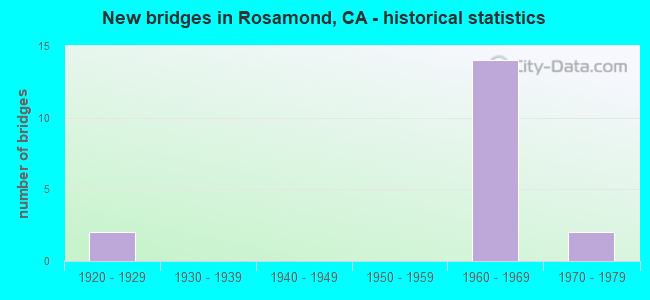
- New bridges - historical statistics
- 21920-1929
- 141960-1969
- 21970-1979


- Bridge Condition - Deck
- 80.0%Good
- 20.0%Satisfactory

- Bridge Condition - Channel
- 25.0%Excellent
- 75.0%Very good
Find on map >> Show street view
Structure Number: 50 0336, Location: 09-KER-014-R3.02 (Lat: 34.864158, Lng: -118.172092), Route carried "on" structure: County highway , Year Built: 1968, Status: Open, Structure Length: 7.19m (23.59ft), Average Daily Traffic: 20,000 (year 2014), Truck Traffic: 9%, Average Future Daily Traffic: 26,018 (year 2041), Design Load: HS 20, Features Intersected: STATE ROUTE 14, Facility Carried by Structure: ROSAMOND BLVD
Minimum Vertical Clearance: 30+ m (98+ ft), Kilometerpoint: 0.000, Lanes on structure: 3, Lanes under structure: 5, Owner: State Highway Agency, Approaching Roadway Width: 18.3m (60.0ft), Material/Design: Concrete continuous, Design/Construction: Box Beam or Girders - Multiple, Number Of Spans In Main Unit: 2, Length of Maximum Span: 38.7m (127.0ft), Curb or Sidewalk Widths: Left: 1.5m (4.9ft), Right: 1.5m (4.9ft), Curb-To-Curb Width: 18.3m (60.0ft), Out-to-Out Width: 22.3m (73.2ft)
Condition: Deck: Satisfactory, Superstructure: Good, Substructure: Good, Operating Rating: 43.1 metric tons, Method Used To Determine Operating Rating: Load and Resistance Factor Rating (LRFR) rating reported by rating factor(RF) method using HL-93 loadings, Inventory Rating: 33.4 metric tons, Method Used To Determine Inventory Rating: Load and Resistance Factor Rating (LRFR) rating reported by rating factor(RF) method using HL-93 loadings, Structural Evaluation: Better than present minimum criteria, Deck Geometry: Superior to present desirable criteria, Underclear: Meets minimum limits, Approach Roadway Alignment: Equal to present desirable criteria, Designated Inspection Frequency: Every 24 months, Inspection Date: April 2021, Deck Structure Type: Concrete Cast-file-Place
Find on map >> Show street view
Structure Number: 50 0382, Location: 09-KER-014-R0.76 (Lat: 34.831539, Lng: -118.169989), Route carried "on" structure: State highway 14, Year Built: 1968, Status: Open, Structure Length: 0.79m (2.59ft), Average Daily Traffic: 30,500 (year 2014), Truck Traffic: 7%, Average Future Daily Traffic: 74,981 (year 2041), Features Intersected: JOSHUA DRAIN
Minimum Vertical Clearance: 30+ m (98+ ft), Kilometerpoint: 0.760, Lanes on structure: 4, Base Highway Network: Yes (, Subroute: 1), Owner: State Highway Agency, Approaching Roadway Width: 11.9m (39.0ft), Skew: 10 degrees, Material/Design: Concrete continuous, Design/Construction: Culvert, Number Of Spans In Main Unit: 3, Length of Maximum Span: 2.7m (8.9ft)
Condition: Channel: Very good, Culverts: Good, Operating Rating: 54.1 metric tons, Method Used To Determine Operating Rating: Field evaluation and documented engineering judgment, Inventory Rating: 32.4 metric tons, Method Used To Determine Inventory Rating: Field evaluation and documented engineering judgment, Structural Evaluation: Better than present minimum criteria, Waterway Adequacy: Equal to present desirable criteria, Approach Roadway Alignment: Equal to present desirable criteria, Designated Inspection Frequency: Every 24 months, Inspection Date: April 2021
Find on map >> Show street view
Structure Number: 50 0385, Location: 09-KER-014-R6.12 (Lat: 34.908056, Lng: -118.164867), Route carried "on" structure: County highway , Year Built: 1972, Status: Open, Structure Length: 7.53m (24.70ft), Average Daily Traffic: 300 (year 2014), Truck Traffic: 9%, Average Future Daily Traffic: 563 (year 2041), Design Load: HS 20, Features Intersected: STATE ROUTE 14, Facility Carried by Structure: DAWN ROAD
Minimum Vertical Clearance: 30+ m (98+ ft), Kilometerpoint: 0.000, Lanes on structure: 2, Lanes under structure: 4, Owner: State Highway Agency, Approaching Roadway Width: 12.2m (40.0ft), Material/Design: Prestressed concrete continuous, Design/Construction: Box Beam or Girders - Multiple, Number Of Spans In Main Unit: 2, Length of Maximum Span: 38.4m (126.0ft), Curb-To-Curb Width: 12.2m (40.0ft), Out-to-Out Width: 12.8m (42.0ft)
Condition: Deck: Good, Superstructure: Good, Substructure: Good, Operating Rating: 59.9 metric tons, Method Used To Determine Operating Rating: Load and Resistance Factor Rating (LRFR) rating reported by rating factor(RF) method using HL-93 loadings, Inventory Rating: 40.2 metric tons, Method Used To Determine Inventory Rating: Load and Resistance Factor Rating (LRFR) rating reported by rating factor(RF) method using HL-93 loadings, Structural Evaluation: Better than present minimum criteria, Deck Geometry: Superior to present desirable criteria, Underclear: Better than present minimum criteria, Approach Roadway Alignment: Equal to present desirable criteria, Designated Inspection Frequency: Every 24 months, Inspection Date: April 2021, Deck Structure Type: Concrete Cast-file-Place
Find on map >> Show street view
Structure Number: 53 1836, Location: 07-LA-014-R77.00 (Lat: 34.820461, Lng: -118.170786), Route carried "on" structure: County highway , Year Built: 1968, Status: Open, Structure Length: 6.77m (22.21ft), Average Daily Traffic: 398 (year 2017), Truck Traffic: 28%, Average Future Daily Traffic: 588 (year 2041), Design Load: HS 20, Features Intersected: ROUTE 14, Facility Carried by Structure: AVENUE "A"
Minimum Vertical Clearance: 30+ m (98+ ft), Kilometerpoint: 0.000, Lanes on structure: 2, Lanes under structure: 4, Owner: State Highway Agency, Approaching Roadway Width: 9.8m (32.2ft), Material/Design: Concrete continuous, Design/Construction: Box Beam or Girders - Multiple, Number Of Spans In Main Unit: 2, Length of Maximum Span: 33.5m (109.9ft), Curb-To-Curb Width: 9.8m (32.2ft), Out-to-Out Width: 10.4m (34.1ft)
Condition: Deck: Good, Superstructure: Good, Substructure: Good, Operating Rating: 35.6 metric tons, Method Used To Determine Operating Rating: Load and Resistance Factor Rating (LRFR) rating reported by rating factor(RF) method using HL-93 loadings, Inventory Rating: 27.5 metric tons, Method Used To Determine Inventory Rating: Load and Resistance Factor Rating (LRFR) rating reported by rating factor(RF) method using HL-93 loadings, Structural Evaluation: Equal to present minimum criteria, Deck Geometry: Better than present minimum criteria, Underclear: Somewhat better than minimum adequacy, Approach Roadway Alignment: Equal to present desirable criteria, Designated Inspection Frequency: Every 24 months, Inspection Date: May 2021, Deck Structure Type: Concrete Cast-file-Place
Find on map >> Show street view
Structure Number: 53 1857, Location: 07-LA-014-R76.01 (Lat: 34.805964, Lng: -118.171261), Route carried "on" structure: County highway , Year Built: 1968, Status: Open, Structure Length: 6.77m (22.21ft), Average Daily Traffic: 28 (year 2017), Truck Traffic: 2%, Average Future Daily Traffic: 41 (year 2041), Design Load: HS 20, Features Intersected: ROUTE 14, Facility Carried by Structure: AVENUE "B"
Minimum Vertical Clearance: 30+ m (98+ ft), Kilometerpoint: 0.000, Lanes on structure: 2, Lanes under structure: 4, Owner: State Highway Agency, Approaching Roadway Width: 9.8m (32.2ft), Material/Design: Concrete continuous, Design/Construction: Box Beam or Girders - Multiple, Number Of Spans In Main Unit: 2, Length of Maximum Span: 33.5m (109.9ft), Curb or Sidewalk Widths: Left: 0.0m, Right: 1.7m (5.6ft), Curb-To-Curb Width: 9.8m (32.2ft), Out-to-Out Width: 12.1m (39.7ft)
Condition: Deck: Good, Superstructure: Good, Substructure: Good, Operating Rating: 39.5 metric tons, Method Used To Determine Operating Rating: Load and Resistance Factor Rating (LRFR) rating reported by rating factor(RF) method using HL-93 loadings, Inventory Rating: 30.5 metric tons, Method Used To Determine Inventory Rating: Load and Resistance Factor Rating (LRFR) rating reported by rating factor(RF) method using HL-93 loadings, Structural Evaluation: Better than present minimum criteria, Deck Geometry: Equal to present desirable criteria, Underclear: Somewhat better than minimum adequacy, Approach Roadway Alignment: Superior to present desirable criteria, Designated Inspection Frequency: Every 24 months, Inspection Date: May 2021, Deck Structure Type: Concrete Cast-file-Place
Find on map >> Show street view
Structure Number: 53 1858, Location: 07-LA-014-R75.01 (Lat: 34.791403, Lng: -118.171150), Route carried "on" structure: County highway , Year Built: 1968, Status: Open, Structure Length: 6.77m (22.21ft), Average Daily Traffic: 17 (year 2017), Truck Traffic: 1%, Average Future Daily Traffic: 27 (year 2041), Design Load: HS 20, Features Intersected: ROUTE 14, Facility Carried by Structure: AVENUE "C"
Minimum Vertical Clearance: 30+ m (98+ ft), Kilometerpoint: 0.000, Lanes on structure: 2, Lanes under structure: 4, Owner: State Highway Agency, Approaching Roadway Width: 9.8m (32.2ft), Material/Design: Concrete continuous, Design/Construction: Box Beam or Girders - Multiple, Number Of Spans In Main Unit: 2, Length of Maximum Span: 33.5m (109.9ft), Curb or Sidewalk Widths: Left: 0.0m, Right: 1.8m (5.9ft), Curb-To-Curb Width: 9.8m (32.2ft), Out-to-Out Width: 12.1m (39.7ft)
Condition: Deck: Good, Superstructure: Good, Substructure: Good, Operating Rating: 39.5 metric tons, Method Used To Determine Operating Rating: Load and Resistance Factor Rating (LRFR) rating reported by rating factor(RF) method using HL-93 loadings, Inventory Rating: 30.5 metric tons, Method Used To Determine Inventory Rating: Load and Resistance Factor Rating (LRFR) rating reported by rating factor(RF) method using HL-93 loadings, Structural Evaluation: Better than present minimum criteria, Deck Geometry: Equal to present desirable criteria, Underclear: Somewhat better than minimum adequacy, Approach Roadway Alignment: Superior to present desirable criteria, Designated Inspection Frequency: Every 24 months, Inspection Date: May 2021, Deck Structure Type: Concrete Cast-file-Place
Find on map >> Show street view
Structure Number: 53 23, Location: 07-LA-014-R75.02 (Lat: 34.791714, Lng: -118.170544), Route carried "on" structure: State highway 14, Year Built: 1968, Status: Open, Structure Length: 1.31m (4.30ft), Average Daily Traffic: 33,500 (year 2019), Truck Traffic: 7%, Average Future Daily Traffic: 57,640 (year 2041), Features Intersected: AVE C DRAIN 3
Minimum Vertical Clearance: 30+ m (98+ ft), Kilometerpoint: 75.020, Lanes on structure: 4, Base Highway Network: Yes (, Subroute: 1), Owner: State Highway Agency, Approaching Roadway Width: 34.9m (114.5ft), Skew: 10 degrees, Material/Design: Concrete continuous, Design/Construction: Culvert, Number Of Spans In Main Unit: 4, Length of Maximum Span: 3.0m (9.8ft), Curb-To-Curb Width: 34.9m (114.5ft), Out-to-Out Width: 58.5m (191.9ft)
Condition: Channel: Very good, Culverts: Good, Operating Rating: 54.1 metric tons, Method Used To Determine Operating Rating: Field evaluation and documented engineering judgment, Inventory Rating: 32.4 metric tons, Method Used To Determine Inventory Rating: Field evaluation and documented engineering judgment, Structural Evaluation: Better than present minimum criteria, Deck Geometry: Superior to present desirable criteria, Waterway Adequacy: Equal to present desirable criteria, Approach Roadway Alignment: Superior to present desirable criteria, Designated Inspection Frequency: Every 48 months, Inspection Date: May 2021
Find on map >> Show street view
Structure Number: 53 2302, Location: 07-LA-014-R75.09 (Lat: 34.792669, Lng: -118.170550), Route carried "on" structure: State highway 14, Year Built: 1968, Status: Open, Structure Length: 1.31m (4.30ft), Average Daily Traffic: 33,500 (year 2019), Truck Traffic: 7%, Average Future Daily Traffic: 57,640 (year 2041), Features Intersected: AVE C DRAIN 5
Minimum Vertical Clearance: 30+ m (98+ ft), Kilometerpoint: 75.090, Lanes on structure: 4, Base Highway Network: Yes (, Subroute: 1), Owner: State Highway Agency, Approaching Roadway Width: 34.9m (114.5ft), Skew: 10 degrees, Material/Design: Concrete continuous, Design/Construction: Culvert, Number Of Spans In Main Unit: 4, Length of Maximum Span: 3.0m (9.8ft), Curb-To-Curb Width: 34.9m (114.5ft), Out-to-Out Width: 57.9m (190.0ft)
Condition: Channel: Very good, Culverts: Good, Operating Rating: 54.1 metric tons, Method Used To Determine Operating Rating: Field evaluation and documented engineering judgment, Inventory Rating: 32.4 metric tons, Method Used To Determine Inventory Rating: Field evaluation and documented engineering judgment, Structural Evaluation: Better than present minimum criteria, Deck Geometry: Superior to present desirable criteria, Waterway Adequacy: Equal to present desirable criteria, Approach Roadway Alignment: Superior to present desirable criteria, Designated Inspection Frequency: Every 48 months, Inspection Date: May 2021
Find on map >> Show street view
Structure Number: 53 2303, Location: 07-LA-014-R76.41 (Lat: 34.811947, Lng: -118.170464), Route carried "on" structure: State highway 14, Year Built: 1968, Status: Open, Structure Length: 1.31m (4.30ft), Average Daily Traffic: 33,500 (year 2019), Truck Traffic: 7%, Average Future Daily Traffic: 57,640 (year 2041), Features Intersected: AVE B DRAIN 1
Minimum Vertical Clearance: 30+ m (98+ ft), Kilometerpoint: 76.410, Lanes on structure: 4, Base Highway Network: Yes (, Subroute: 1), Owner: State Highway Agency, Approaching Roadway Width: 35.2m (115.5ft), Skew: 10 degrees, Material/Design: Concrete continuous, Design/Construction: Culvert, Number Of Spans In Main Unit: 4, Length of Maximum Span: 3.0m (9.8ft), Curb-To-Curb Width: 35.2m (115.5ft), Out-to-Out Width: 68.6m (225.1ft)
Condition: Channel: Very good, Culverts: Good, Operating Rating: 54.1 metric tons, Method Used To Determine Operating Rating: Field evaluation and documented engineering judgment, Inventory Rating: 32.4 metric tons, Method Used To Determine Inventory Rating: Field evaluation and documented engineering judgment, Structural Evaluation: Better than present minimum criteria, Deck Geometry: Superior to present desirable criteria, Waterway Adequacy: Equal to present desirable criteria, Approach Roadway Alignment: Superior to present desirable criteria, Designated Inspection Frequency: Every 48 months, Inspection Date: May 2021
Find on map >> Show street view
Structure Number: 53 2304, Location: 07-LA-014-R76.50 (Lat: 34.813036, Lng: -118.170425), Route carried "on" structure: State highway 14, Year Built: 1968, Status: Open, Structure Length: 1.31m (4.30ft), Average Daily Traffic: 33,500 (year 2019), Truck Traffic: 7%, Average Future Daily Traffic: 57,640 (year 2041), Features Intersected: AVE B DRAIN 2
Minimum Vertical Clearance: 30+ m (98+ ft), Kilometerpoint: 76.500, Lanes on structure: 4, Base Highway Network: Yes (, Subroute: 1), Owner: State Highway Agency, Approaching Roadway Width: 35.2m (115.5ft), Skew: 10 degrees, Material/Design: Concrete continuous, Design/Construction: Culvert, Number Of Spans In Main Unit: 4, Length of Maximum Span: 3.0m (9.8ft), Curb-To-Curb Width: 35.2m (115.5ft), Out-to-Out Width: 65.8m (215.9ft)
Condition: Channel: Very good, Culverts: Good, Operating Rating: 54.1 metric tons, Method Used To Determine Operating Rating: Field evaluation and documented engineering judgment, Inventory Rating: 32.4 metric tons, Method Used To Determine Inventory Rating: Field evaluation and documented engineering judgment, Structural Evaluation: Better than present minimum criteria, Deck Geometry: Superior to present desirable criteria, Waterway Adequacy: Equal to present desirable criteria, Approach Roadway Alignment: Superior to present desirable criteria, Designated Inspection Frequency: Every 48 months, Inspection Date: May 2021
Find on map >> Show street view
Structure Number: 53 2305, Location: 07-LA-014-R76.58 (Lat: 34.814147, Lng: -118.170389), Route carried "on" structure: State highway 14, Year Built: 1968, Status: Open, Structure Length: 1.31m (4.30ft), Average Daily Traffic: 33,500 (year 2019), Truck Traffic: 7%, Average Future Daily Traffic: 57,640 (year 2041), Features Intersected: AVE B DRAIN 3
Minimum Vertical Clearance: 30+ m (98+ ft), Kilometerpoint: 76.580, Lanes on structure: 4, Base Highway Network: Yes (, Subroute: 1), Owner: State Highway Agency, Approaching Roadway Width: 35.2m (115.5ft), Skew: 10 degrees, Material/Design: Concrete continuous, Design/Construction: Culvert, Number Of Spans In Main Unit: 4, Length of Maximum Span: 3.0m (9.8ft), Curb-To-Curb Width: 35.2m (115.5ft), Out-to-Out Width: 66.8m (219.2ft)
Condition: Channel: Very good, Culverts: Good, Operating Rating: 54.1 metric tons, Method Used To Determine Operating Rating: Field evaluation and documented engineering judgment, Inventory Rating: 32.4 metric tons, Method Used To Determine Inventory Rating: Field evaluation and documented engineering judgment, Structural Evaluation: Better than present minimum criteria, Deck Geometry: Superior to present desirable criteria, Waterway Adequacy: Equal to present desirable criteria, Approach Roadway Alignment: Superior to present desirable criteria, Designated Inspection Frequency: Every 48 months, Inspection Date: May 2021
Find on map >> Show street view
Structure Number: 53C0388, Location: 2.2MI S/O KERN CO LINE (Lat: 34.788942, Lng: -118.150783), Route carried "on" structure: County highway L639, Year Built: 1921, Year Reconstructed: 1931, Status: Open, Structure Length: 0.64m (2.10ft), Average Daily Traffic: 3,838 (year 2012), Truck Traffic: 2%, Average Future Daily Traffic: 4,222 (year 2040), Features Intersected: OBAN WASH, Facility Carried by Structure: SIERRA HWY
Minimum Vertical Clearance: 30.47m (99.97ft), Kilometerpoint: 0.000, Lanes on structure: 2, Owner: County Highway Agency, Approaching Roadway Width: 10.6m (34.8ft), Material/Design: Concrete, Design/Construction: Culvert, Number Of Spans In Main Unit: 2, Length of Maximum Span: 3.0m (9.8ft), Curb-To-Curb Width: 7.5m (24.6ft), Out-to-Out Width: 14.7m (48.2ft)
Condition: Channel: Excellent, Culverts: Good, Operating Rating: 40.5 metric tons, Method Used To Determine Operating Rating: Field evaluation and documented engineering judgment, Inventory Rating: 24.3 metric tons, Method Used To Determine Inventory Rating: Field evaluation and documented engineering judgment, Structural Evaluation: Equal to present minimum criteria, Deck Geometry: High priority of replacement, Waterway Adequacy: Meets minimum limits, Approach Roadway Alignment: Equal to present desirable criteria, Designated Inspection Frequency: Every 24 months, Inspection Date: June 2020
Find on map >> Show street view
Structure Number: 53C0389, Location: 2.0MI S/O KERN CO LINE (Lat: 34.791847, Lng: -118.151411), Route carried "on" structure: County highway L639, Year Built: 1921, Year Reconstructed: 1931, Status: Open, Structure Length: 0.64m (2.10ft), Average Daily Traffic: 3,838 (year 2012), Truck Traffic: 2%, Average Future Daily Traffic: 4,222 (year 2040), Features Intersected: UNNAMED WASH, Facility Carried by Structure: SIERRA HWY
Minimum Vertical Clearance: 30.47m (99.97ft), Kilometerpoint: 0.000, Lanes on structure: 2, Owner: County Highway Agency, Approaching Roadway Width: 11.6m (38.1ft), Material/Design: Concrete, Design/Construction: Culvert, Number Of Spans In Main Unit: 2, Length of Maximum Span: 3.0m (9.8ft), Curb-To-Curb Width: 7.6m (24.9ft), Out-to-Out Width: 14.9m (48.9ft)
Condition: Channel: Excellent, Culverts: Good, Operating Rating: 40.5 metric tons, Method Used To Determine Operating Rating: Field evaluation and documented engineering judgment, Inventory Rating: 24.3 metric tons, Method Used To Determine Inventory Rating: Field evaluation and documented engineering judgment, Structural Evaluation: Equal to present minimum criteria, Deck Geometry: High priority of replacement, Waterway Adequacy: Meets minimum limits, Approach Roadway Alignment: Superior to present desirable criteria, Designated Inspection Frequency: Every 24 months, Inspection Date: June 2020
Find on map >> Show street view
Structure Number: 50 0336, Location: 09-KER-014-R3.02 (Lat: 34.864158, Lng: -118.172092), Route carried "under" structure: State highway 14, Year Built: 1968, Structure Length: 0. m, Average Daily Traffic: 56,000 (year 2014), Truck Traffic: 9%, Features Intersected: STATE ROUTE 14, Facility Carried by Structure: ROSAMOND BLVD
Minimum Vertical Clearance: 4.64m (15.22ft), Kilometerpoint: 3.020, Lanes on structure: 3, Lanes under structure: 5, Material/Design: Concrete continuous, Design/Construction: Box Beam or Girders - Multiple, Length of Maximum Span: 38.7m (127.0ft)
Find on map >> Show street view
Structure Number: 50 0385, Location: 09-KER-014-R6.12 (Lat: 34.908056, Lng: -118.164867), Route carried "under" structure: State highway 14, Year Built: 1972, Structure Length: 0. m, Average Daily Traffic: 39,000 (year 2014), Truck Traffic: 18%, Features Intersected: STATE ROUTE 14, Facility Carried by Structure: DAWN ROAD
Minimum Vertical Clearance: 5.28m (17.32ft), Kilometerpoint: 6.120, Lanes on structure: 2, Lanes under structure: 4, Material/Design: Prestressed concrete continuous, Design/Construction: Box Beam or Girders - Multiple, Length of Maximum Span: 38.4m (126.0ft)
Find on map >> Show street view
Structure Number: 53 1836, Location: 07-LA-014-R77.00 (Lat: 34.820461, Lng: -118.170786), Route carried "under" structure: State highway 14, Year Built: 1968, Structure Length: 0. m, Average Daily Traffic: 37,500 (year 2017), Truck Traffic: 5%, Features Intersected: ROUTE 14, Facility Carried by Structure: AVENUE "A"
Minimum Vertical Clearance: 4.59m (15.06ft), Kilometerpoint: 77.000, Lanes on structure: 2, Lanes under structure: 4, Material/Design: Concrete continuous, Design/Construction: Box Beam or Girders - Multiple, Length of Maximum Span: 33.5m (109.9ft)
Find on map >> Show street view
Structure Number: 53 1857, Location: 07-LA-014-R76.01 (Lat: 34.805964, Lng: -118.171261), Route carried "under" structure: State highway 14, Year Built: 1968, Structure Length: 0. m, Average Daily Traffic: 37,500 (year 2017), Truck Traffic: 5%, Features Intersected: ROUTE 14, Facility Carried by Structure: AVENUE "B"
Minimum Vertical Clearance: 4.52m (14.83ft), Kilometerpoint: 76.010, Lanes on structure: 2, Lanes under structure: 4, Material/Design: Concrete continuous, Design/Construction: Box Beam or Girders - Multiple, Length of Maximum Span: 33.5m (109.9ft)
Find on map >> Show street view
Structure Number: 53 1858, Location: 07-LA-014-R75.01 (Lat: 34.791403, Lng: -118.171150), Route carried "under" structure: State highway 14, Year Built: 1968, Structure Length: 0. m, Average Daily Traffic: 37,500 (year 2017), Truck Traffic: 5%, Features Intersected: ROUTE 14, Facility Carried by Structure: AVENUE "C"
Minimum Vertical Clearance: 4.52m (14.83ft), Kilometerpoint: 75.010, Lanes on structure: 2, Lanes under structure: 4, Material/Design: Concrete continuous, Design/Construction: Box Beam or Girders - Multiple, Length of Maximum Span: 33.5m (109.9ft)