Bridge Statistics for Rock Island, Illinois (IL)
Condition, Traffic, Stress, Structural Evaluation, Project Costs
- National Bridge Inventory (NBI) Statistics
- 40Number of bridges
- 1,001ft / 305mTotal length
- $14,112,000Total costs
- 337,175Total average daily traffic
- 40,282Total average daily truck traffic
- National Bridge Inventory (NBI) Registered Bridges for Rock Island
- No street view available for this location
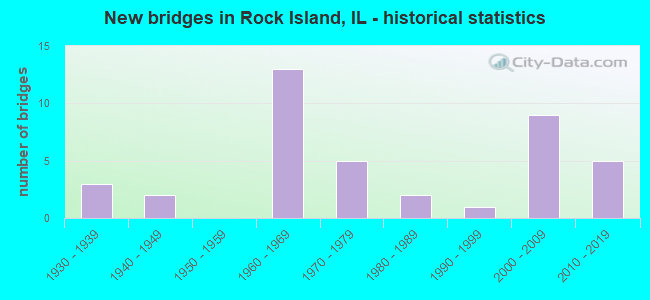
- New bridges - historical statistics
- 31930-1939
- 21940-1949
- 131960-1969
- 51970-1979
- 21980-1989
- 11990-1999
- 92000-2009
- 52010-2019

- Reconstructed bridges - Historical Statistics
- 71990-1999
- 42000-2009


- Bridge Condition - Deck
- 11.5%Very good
- 19.2%Good
- 69.2%Satisfactory

- Bridge Condition - Superstructure
- 23.1%Very good
- 38.5%Good
- 23.1%Satisfactory
- 11.5%Fair
- 3.8%Poor

- Bridge Condition - Substructure
- 26.9%Very good
- 46.2%Good
- 15.4%Satisfactory
- 11.5%Fair

- Bridge Condition - Channel
- 12.5%Very good
- 56.3%Good
- 25.0%Satisfactory
- 6.3%Fair
Find on map >> Show street view
Structure Number: 810064, Location: .2 MI S 18TH ST R.I. (Lat: 41.492044, Lng: -90.593981), Route carried "on" structure: State highway 92, Year Built: 1963, Year Reconstructed: 2009, Status: Open, Structure Length: 6.97m (22.87ft), Average Daily Traffic: 9,150 (year 2021), Truck Traffic: 11%, Average Future Daily Traffic: 11,400 (year 2040), Design Load: HS 20+Mod, Features Intersected: IAIS RR
Minimum Vertical Clearance: 30+ m (98+ ft), Kilometerpoint: 45.962, Lanes on structure: 4, Base Highway Network: Yes, Owner: State Highway Agency, Approaching Roadway Width: 21.9m (71.9ft), Skew: 35 degrees, Material/Design: Steel continuous, Design/Construction: Stringer/Multi-beam, Number Of Spans In Main Unit: 3, Length of Maximum Span: 26.5m (86.9ft), Curb-To-Curb Width: 22.9m (75.1ft), Out-to-Out Width: 24.7m (81.0ft)
Condition: Deck: Satisfactory, Superstructure: Fair, Substructure: Good, Operating Rating: 72.3 metric tons, Method Used To Determine Operating Rating: Load Factor (LF) rating reported by rating factor (RF) method using MS18 loading, Inventory Rating: 43.4 metric tons, Method Used To Determine Inventory Rating: Load Factor (LF) rating reported by rating factor (RF) method using MS18 loading, Structural Evaluation: Somewhat better than minimum adequacy, Deck Geometry: Superior to present desirable criteria, Underclear: Equal to present desirable criteria, Approach Roadway Alignment: Equal to present desirable criteria, Length Of Structure Improvement: 6.98m (22.90ft), Designated Inspection Frequency: Every 24 months, Inspection Date: August 2021, Bridge Improvement Cost: $1,411,000, Roadway Improvement Cost: $141,000, Total Project Cost: $2,117,000, Deck Structure Type: Concrete Cast-file-Place, Wearing Surface/Protective System: Deck Protection: Epoxy Coated Reinforcing
Find on map >> Show street view
Structure Number: 810067, Location: .5 MI S 31ST ST R.I. (Lat: 41.479050, Lng: -90.604897), Route carried "on" structure: State highway 92, Year Built: 1963, Year Reconstructed: 2002, Status: Open, Structure Length: 28.77m (94.39ft), Average Daily Traffic: 10,700 (year 2021), Truck Traffic: 11%, Average Future Daily Traffic: 6,900 (year 2040), Design Load: HS 20+Mod, Features Intersected: ROCK RIVER-HEN CANAL
Minimum Vertical Clearance: 30+ m (98+ ft), Kilometerpoint: 44.224, Lanes on structure: 2, Base Highway Network: Yes, Owner: State Highway Agency, Approaching Roadway Width: 11.2m (36.7ft), Skew: 1 degrees, Navigation Control: Yes ( Vertical Clearance: 5.5m (18.0ft), Horizontal Clearance: 32.0m (105.0ft)), Material/Design: Steel, Design/Construction: Stringer/Multi-beam, Number Of Spans In Main Unit: 8, Number Of Approach Spans: 2, Length of Maximum Span: 34.1m (111.9ft), Curb-To-Curb Width: 11.2m (36.7ft), Out-to-Out Width: 12.2m (40.0ft)
Condition: Deck: Satisfactory, Superstructure: Fair, Substructure: Fair, Channel: Good, Operating Rating: 69.7 metric tons, Method Used To Determine Operating Rating: Load Factor (LF) rating reported by rating factor (RF) method using MS18 loading, Inventory Rating: 41.8 metric tons, Method Used To Determine Inventory Rating: Load Factor (LF) rating reported by rating factor (RF) method using MS18 loading, Structural Evaluation: Somewhat better than minimum adequacy, Deck Geometry: Somewhat better than minimum adequacy, Waterway Adequacy: Equal to present desirable criteria, Approach Roadway Alignment: Equal to present desirable criteria, Length Of Structure Improvement: 28.77m (94.39ft), Designated Inspection Frequency: Every 24 months, Underwater Inspection Frequency: Every 24 months, Inspection Date: August 2020, Underwater Inspection Date: September 2021, Bridge Improvement Cost: $2,617,000, Roadway Improvement Cost: $262,000, Total Project Cost: $3,926,000, Deck Structure Type: Concrete Cast-file-Place, Wearing Surface/Protective System: Deck Protection: Epoxy Coated Reinforcing
Find on map >> Show street view
Structure Number: 810068, Location: .5 MI S 31ST ST R.I. (Lat: 41.478881, Lng: -90.605003), Route carried "on" structure: State highway 92, Year Built: 1963, Year Reconstructed: 2002, Status: Open, Structure Length: 28.77m (94.39ft), Average Daily Traffic: 10,700 (year 2021), Truck Traffic: 11%, Average Future Daily Traffic: 6,900 (year 2040), Design Load: HS 20, Features Intersected: ROCK RIVER-HEN CANAL
Minimum Vertical Clearance: 30+ m (98+ ft), Kilometerpoint: 44.207, Lanes on structure: 2, Base Highway Network: Yes, Owner: State Highway Agency, Approaching Roadway Width: 11.2m (36.7ft), Skew: 1 degrees, Navigation Control: Yes ( Vertical Clearance: 5.5m (18.0ft), Horizontal Clearance: 32.0m (105.0ft)), Material/Design: Steel, Design/Construction: Stringer/Multi-beam, Number Of Spans In Main Unit: 8, Number Of Approach Spans: 2, Length of Maximum Span: 34.1m (111.9ft), Curb-To-Curb Width: 11.2m (36.7ft), Out-to-Out Width: 12.2m (40.0ft)
Condition: Deck: Satisfactory, Superstructure: Fair, Substructure: Fair, Channel: Good, Operating Rating: 69.7 metric tons, Method Used To Determine Operating Rating: Load Factor (LF) rating reported by rating factor (RF) method using MS18 loading, Inventory Rating: 41.8 metric tons, Method Used To Determine Inventory Rating: Load Factor (LF) rating reported by rating factor (RF) method using MS18 loading, Structural Evaluation: Somewhat better than minimum adequacy, Deck Geometry: Somewhat better than minimum adequacy, Waterway Adequacy: Equal to present desirable criteria, Approach Roadway Alignment: Equal to present desirable criteria, Length Of Structure Improvement: 28.77m (94.39ft), Designated Inspection Frequency: Every 24 months, Underwater Inspection Frequency: Every 24 months, Inspection Date: August 2020, Underwater Inspection Date: September 2021, Bridge Improvement Cost: $2,617,000, Roadway Improvement Cost: $262,000, Total Project Cost: $3,926,000, Deck Structure Type: Concrete Cast-file-Place, Wearing Surface/Protective System: Deck Protection: Epoxy Coated Reinforcing
Find on map >> Show street view
Structure Number: 810069, Location: .6 MI S 31ST ST R.I. (Lat: 41.475883, Lng: -90.606947), Route carried "on" structure: State highway 92, Year Built: 1963, Year Reconstructed: 2002, Status: Open, Structure Length: 3.15m (10.33ft), Average Daily Traffic: 10,700 (year 2021), Truck Traffic: 11%, Average Future Daily Traffic: 6,900 (year 2040), Design Load: HS 20+Mod, Features Intersected: W. 27TH ST R.I.
Minimum Vertical Clearance: 30+ m (98+ ft), Kilometerpoint: 43.918, Lanes on structure: 2, Lanes under structure: 2, Base Highway Network: Yes, Owner: State Highway Agency, Approaching Roadway Width: 11.6m (38.1ft), Skew: 1 degrees, Material/Design: Concrete continuous, Design/Construction: Slab, Number Of Spans In Main Unit: 3, Length of Maximum Span: 11.6m (38.1ft), Curb-To-Curb Width: 11.2m (36.7ft), Out-to-Out Width: 12.2m (40.0ft)
Condition: Deck: Satisfactory, Superstructure: Satisfactory, Substructure: Good, Operating Rating: 76.8 metric tons, Method Used To Determine Operating Rating: Load Factor (LF) rating reported by rating factor (RF) method using MS18 loading, Inventory Rating: 46.0 metric tons, Method Used To Determine Inventory Rating: Load Factor (LF) rating reported by rating factor (RF) method using MS18 loading, Structural Evaluation: Equal to present minimum criteria, Deck Geometry: Somewhat better than minimum adequacy, Underclear: Meets minimum limits, Approach Roadway Alignment: Equal to present desirable criteria, Length Of Structure Improvement: 4.08m (13.39ft), Designated Inspection Frequency: Every 24 months, Inspection Date: September 2020, Bridge Improvement Cost: $611,000, Roadway Improvement Cost: $61,000, Total Project Cost: $917,000, Deck Structure Type: Concrete Cast-file-Place, Wearing Surface/Protective System: Deck Protection: Epoxy Coated Reinforcing
Find on map >> Show street view
Structure Number: 810081, Location: 1 MI E OF US 67 (Lat: 41.464644, Lng: -90.564792), Route carried "on" structure: State highway 5, Year Built: 1932, Year Reconstructed: 2000, Status: Open, Structure Length: 1.04m (3.41ft), Average Daily Traffic: 11,200 (year 2021), Truck Traffic: 4%, Average Future Daily Traffic: 15,200 (year 2040), Design Load: HS 20, Features Intersected: MILL CREEK
Minimum Vertical Clearance: 30+ m (98+ ft), Kilometerpoint: 1.577, Lanes on structure: 2, Base Highway Network: Yes, Owner: State Highway Agency, Approaching Roadway Width: 14.6m (47.9ft), Skew: 10 degrees, Material/Design: Concrete, Design/Construction: Slab, Number Of Spans In Main Unit: 1, Length of Maximum Span: 9.8m (32.2ft), Curb-To-Curb Width: 15.8m (51.8ft), Out-to-Out Width: 16.6m (54.5ft)
Condition: Deck: Satisfactory, Superstructure: Satisfactory, Substructure: Satisfactory, Channel: Satisfactory, Operating Rating: 66.7 metric tons, Method Used To Determine Operating Rating: Load Factor (LF) rating reported by rating factor (RF) method using MS18 loading, Inventory Rating: 40.2 metric tons, Method Used To Determine Inventory Rating: Load Factor (LF) rating reported by rating factor (RF) method using MS18 loading, Structural Evaluation: Equal to present minimum criteria, Deck Geometry: Superior to present desirable criteria, Waterway Adequacy: Equal to present desirable criteria, Approach Roadway Alignment: Equal to present desirable criteria, Length Of Structure Improvement: 1.01m (3.31ft), Designated Inspection Frequency: Every 24 months, Inspection Date: December 2021, Bridge Improvement Cost: $93,000, Roadway Improvement Cost: $9,000, Total Project Cost: $140,000, Deck Structure Type: Concrete Cast-file-Place, Wearing Surface/Protective System: Deck Protection: Epoxy Coated Reinforcing
Find on map >> Show street view
Structure Number: 810087, Location: .2 MI N OF ILL 5 (Lat: 41.467203, Lng: -90.565450), Route carried "on" structure: Other road , Year Built: 1933, Year Reconstructed: 2005, Status: Open, Structure Length: 1.30m (4.27ft), Average Daily Traffic: 6,300 (year 2020), Truck Traffic: 5%, Average Future Daily Traffic: 9,300 (year 2040), Design Load: HS 20, Features Intersected: STREAM, Facility Carried by Structure: 24TH ST ROCK ISLAN
Minimum Vertical Clearance: 30+ m (98+ ft), Kilometerpoint: 0.274, Lanes on structure: 2, Base Highway Network: Yes, Owner: City or Municipal Highway Agency, Approaching Roadway Width: 13.3m (43.6ft), Material/Design: Prestressed concrete, Design/Construction: Box Beam or Girders - Multiple, Number Of Spans In Main Unit: 1, Length of Maximum Span: 12.6m (41.3ft), Curb-To-Curb Width: 14.4m (47.2ft), Out-to-Out Width: 14.6m (47.9ft)
Condition: Deck: Very good, Superstructure: Very good, Substructure: Good, Channel: Very good, Operating Rating: 44.4 metric tons, Method Used To Determine Operating Rating: Load Factor (LF) rating reported by rating factor (RF) method using MS18 loading, Inventory Rating: 32.4 metric tons, Method Used To Determine Inventory Rating: Load Factor (LF) rating reported by rating factor (RF) method using MS18 loading, Structural Evaluation: Better than present minimum criteria, Deck Geometry: Superior to present desirable criteria, Waterway Adequacy: Equal to present desirable criteria, Approach Roadway Alignment: Equal to present desirable criteria, Designated Inspection Frequency: Every 48 months, Inspection Date: March 2020, Deck Structure Type: Concrete Precast Panels, Wearing Surface/Protective System: Wearing Surface: Bituminous, Membrane: Built-up
Find on map >> Show street view
Structure Number: 810088, Location: .1MI N OF ILL 5 (Lat: 41.465903, Lng: -90.565528), Route carried "on" structure: Other road , Year Built: 1934, Year Reconstructed: 2005, Status: Open, Structure Length: 1.30m (4.27ft), Average Daily Traffic: 6,300 (year 2020), Truck Traffic: 5%, Average Future Daily Traffic: 9,300 (year 2040), Design Load: HS 20, Features Intersected: STREAM, Facility Carried by Structure: 24TH ST ROCK ISLAN
Minimum Vertical Clearance: 30+ m (98+ ft), Kilometerpoint: 0.129, Lanes on structure: 2, Base Highway Network: Yes, Owner: City or Municipal Highway Agency, Approaching Roadway Width: 9.5m (31.2ft), Material/Design: Prestressed concrete, Design/Construction: Box Beam or Girders - Multiple, Number Of Spans In Main Unit: 1, Length of Maximum Span: 12.6m (41.3ft), Curb-To-Curb Width: 10.5m (34.4ft), Out-to-Out Width: 10.7m (35.1ft)
Condition: Deck: Good, Superstructure: Good, Substructure: Good, Channel: Good, Operating Rating: 44.4 metric tons, Method Used To Determine Operating Rating: Load Factor (LF) rating reported by rating factor (RF) method using MS18 loading, Inventory Rating: 32.4 metric tons, Method Used To Determine Inventory Rating: Load Factor (LF) rating reported by rating factor (RF) method using MS18 loading, Structural Evaluation: Better than present minimum criteria, Deck Geometry: Meets minimum limits, Waterway Adequacy: Equal to present desirable criteria, Approach Roadway Alignment: Equal to present desirable criteria, Length Of Structure Improvement: 2.01m (6.59ft), Designated Inspection Frequency: Every 48 months, Inspection Date: March 2020, Bridge Improvement Cost: $160,000, Roadway Improvement Cost: $16,000, Total Project Cost: $240,000, Deck Structure Type: Concrete Precast Panels, Wearing Surface/Protective System: Wearing Surface: Bituminous, Membrane: Built-up
Find on map >> Show street view
Structure Number: 810091, Location: .4 MI N ANDALUSIA RD (Lat: 41.451067, Lng: -90.620531), Route carried "on" structure: State highway 92, Year Built: 1960, Status: Open, Structure Length: 3.78m (12.40ft), Average Daily Traffic: 15,600 (year 2021), Truck Traffic: 15%, Average Future Daily Traffic: 8,600 (year 2040), Design Load: HS 20, Features Intersected: MILL CREEK
Minimum Vertical Clearance: 30+ m (98+ ft), Kilometerpoint: 40.892, Lanes on structure: 2, Base Highway Network: Yes, Owner: State Highway Agency, Approaching Roadway Width: 10.4m (34.1ft), Material/Design: Steel continuous, Design/Construction: Stringer/Multi-beam, Number Of Spans In Main Unit: 3, Length of Maximum Span: 13.4m (44.0ft), Curb-To-Curb Width: 9.1m (29.9ft), Out-to-Out Width: 11.1m (36.4ft)
Condition: Deck: Satisfactory, Superstructure: Satisfactory, Substructure: Good, Channel: Good, Operating Rating: 56.7 metric tons, Method Used To Determine Operating Rating: Load Factor (LF) rating reported by rating factor (RF) method using MS18 loading, Inventory Rating: 31.8 metric tons, Method Used To Determine Inventory Rating: Load Factor (LF) rating reported by rating factor (RF) method using MS18 loading, Structural Evaluation: Equal to present minimum criteria, Deck Geometry: Meets minimum limits, Waterway Adequacy: Equal to present desirable criteria, Approach Roadway Alignment: Equal to present desirable criteria, Designated Inspection Frequency: Every 24 months, Inspection Date: January 2022, Deck Structure Type: Concrete Cast-file-Place, Wearing Surface/Protective System: Wearing Surface: Bituminous, Membrane: Built-up
Find on map >> Show street view
Structure Number: 810092, Location: .4 MI N ANDALUSIA RD (Lat: 41.450922, Lng: -90.620533), Route carried "on" structure: State highway 92, Year Built: 1960, Status: Open, Structure Length: 3.77m (12.37ft), Average Daily Traffic: 15,600 (year 2021), Truck Traffic: 15%, Average Future Daily Traffic: 8,600 (year 2040), Design Load: HS 20+Mod, Features Intersected: MILL CREEK
Minimum Vertical Clearance: 30+ m (98+ ft), Kilometerpoint: 40.876, Lanes on structure: 2, Base Highway Network: Yes, Owner: State Highway Agency, Approaching Roadway Width: 10.4m (34.1ft), Material/Design: Steel continuous, Design/Construction: Stringer/Multi-beam, Number Of Spans In Main Unit: 3, Length of Maximum Span: 13.4m (44.0ft), Curb-To-Curb Width: 9.1m (29.9ft), Out-to-Out Width: 11.1m (36.4ft)
Condition: Deck: Satisfactory, Superstructure: Satisfactory, Substructure: Good, Channel: Good, Operating Rating: 56.7 metric tons, Method Used To Determine Operating Rating: Load Factor (LF) rating reported by rating factor (RF) method using MS18 loading, Inventory Rating: 31.8 metric tons, Method Used To Determine Inventory Rating: Load Factor (LF) rating reported by rating factor (RF) method using MS18 loading, Structural Evaluation: Equal to present minimum criteria, Deck Geometry: Meets minimum limits, Waterway Adequacy: Equal to present desirable criteria, Approach Roadway Alignment: Equal to present desirable criteria, Designated Inspection Frequency: Every 24 months, Inspection Date: January 2022, Deck Structure Type: Concrete Cast-file-Place, Wearing Surface/Protective System: Wearing Surface: Bituminous, Membrane: Built-up
Find on map >> Show street view
Structure Number: 810094, Location: .6 MI S 31ST ST R.I. (Lat: 41.475750, Lng: -90.607036), Route carried "on" structure: State highway 92, Year Built: 1963, Year Reconstructed: 2002, Status: Open, Structure Length: 3.15m (10.33ft), Average Daily Traffic: 10,700 (year 2021), Truck Traffic: 11%, Average Future Daily Traffic: 6,800 (year 2040), Design Load: HS 20+Mod, Features Intersected: W. 27TH ST R.I.
Minimum Vertical Clearance: 30+ m (98+ ft), Kilometerpoint: 43.902, Lanes on structure: 2, Lanes under structure: 2, Base Highway Network: Yes, Owner: State Highway Agency, Approaching Roadway Width: 11.6m (38.1ft), Skew: 1 degrees, Material/Design: Concrete continuous, Design/Construction: Slab, Number Of Spans In Main Unit: 3, Length of Maximum Span: 11.6m (38.1ft), Curb-To-Curb Width: 11.2m (36.7ft), Out-to-Out Width: 12.2m (40.0ft)
Condition: Deck: Satisfactory, Superstructure: Satisfactory, Substructure: Good, Operating Rating: 76.8 metric tons, Method Used To Determine Operating Rating: Load Factor (LF) rating reported by rating factor (RF) method using MS18 loading, Inventory Rating: 46.0 metric tons, Method Used To Determine Inventory Rating: Load Factor (LF) rating reported by rating factor (RF) method using MS18 loading, Structural Evaluation: Equal to present minimum criteria, Deck Geometry: Somewhat better than minimum adequacy, Underclear: Meets minimum limits, Approach Roadway Alignment: Equal to present desirable criteria, Length Of Structure Improvement: 4.05m (13.29ft), Designated Inspection Frequency: Every 24 months, Inspection Date: September 2020, Bridge Improvement Cost: $606,000, Roadway Improvement Cost: $61,000, Total Project Cost: $910,000, Deck Structure Type: Concrete Cast-file-Place, Wearing Surface/Protective System: Deck Protection: Epoxy Coated Reinforcing
Find on map >> Show street view
Structure Number: 810117, Location: 3 MI E OF ANDALUSIA (Lat: 41.444142, Lng: -90.648458), Route carried "on" structure: State highway 92, Year Built: 1975, Status: Open, Structure Length: 2.32m (7.61ft), Average Daily Traffic: 5,000 (year 2021), Truck Traffic: 6%, Average Future Daily Traffic: 5,700 (year 2040), Design Load: HS 20+Mod, Features Intersected: TURKEY HOLLOW CREEK
Minimum Vertical Clearance: 30+ m (98+ ft), Kilometerpoint: 37.738, Lanes on structure: 2, Base Highway Network: Yes, Owner: State Highway Agency, Approaching Roadway Width: 13.4m (44.0ft), Material/Design: Prestressed concrete, Design/Construction: Box Beam or Girders - Multiple, Number Of Spans In Main Unit: 1, Length of Maximum Span: 22.9m (75.1ft), Curb-To-Curb Width: 13.4m (44.0ft), Out-to-Out Width: 13.7m (44.9ft)
Condition: Deck: Satisfactory, Superstructure: Satisfactory, Substructure: Satisfactory, Channel: Good, Operating Rating: 89.1 metric tons, Method Used To Determine Operating Rating: Load Factor (LF) rating reported by rating factor (RF) method using MS18 loading, Inventory Rating: 62.2 metric tons, Method Used To Determine Inventory Rating: Load Factor (LF) rating reported by rating factor (RF) method using MS18 loading, Structural Evaluation: Equal to present minimum criteria, Deck Geometry: Better than present minimum criteria, Waterway Adequacy: Equal to present desirable criteria, Approach Roadway Alignment: Equal to present desirable criteria, Designated Inspection Frequency: Every 24 months, Inspection Date: October 2020, Deck Structure Type: Concrete Precast Panels, Wearing Surface/Protective System: Wearing Surface: Integral Concrete
Find on map >> Show street view
Structure Number: 810118, Location: 4 MI E OF ANDALUSIA (Lat: 41.443842, Lng: -90.632067), Route carried "on" structure: State highway 92, Year Built: 1975, Status: Open, Structure Length: 1.59m (5.22ft), Average Daily Traffic: 9,750 (year 2019), Truck Traffic: 8%, Average Future Daily Traffic: 10,400 (year 2040), Design Load: HS 20+Mod, Features Intersected: WARREN CREEK
Minimum Vertical Clearance: 30+ m (98+ ft), Kilometerpoint: 39.154, Lanes on structure: 2, Base Highway Network: Yes, Owner: State Highway Agency, Approaching Roadway Width: 13.4m (44.0ft), Material/Design: Prestressed concrete, Design/Construction: Box Beam or Girders - Multiple, Number Of Spans In Main Unit: 1, Length of Maximum Span: 15.2m (49.9ft), Curb-To-Curb Width: 13.5m (44.3ft), Out-to-Out Width: 13.7m (44.9ft)
Condition: Deck: Good, Superstructure: Good, Substructure: Satisfactory, Channel: Fair, Operating Rating: 89.1 metric tons, Method Used To Determine Operating Rating: Load Factor (LF) rating reported by rating factor (RF) method using MS18 loading, Inventory Rating: 57.7 metric tons, Method Used To Determine Inventory Rating: Load Factor (LF) rating reported by rating factor (RF) method using MS18 loading, Structural Evaluation: Equal to present minimum criteria, Deck Geometry: Superior to present desirable criteria, Waterway Adequacy: Equal to present desirable criteria, Approach Roadway Alignment: Equal to present desirable criteria, Designated Inspection Frequency: Every 24 months, Other Special Inspection Frequency: Every 48 months, Inspection Date: July 2021, Other Special Inspection Date: July 2019, Deck Structure Type: Concrete Precast Panels, Wearing Surface/Protective System: Wearing Surface: Bituminous, Membrane: Built-up
Find on map >> Show street view
Structure Number: 810153, Location: S. OF ROCK ISLAND (Lat: 41.462150, Lng: -90.537278), Route carried "on" structure: Other road , Year Built: 2006, Status: Open, Structure Length: 51.27m (168.21ft), Average Daily Traffic: 18,900 (year 2020), Truck Traffic: 8%, Average Future Daily Traffic: 50,700 (year 2040), Design Load: HS 20+Mod, Features Intersected: ROCK RIVER, Facility Carried by Structure: MILAN BELTWAY
Minimum Vertical Clearance: 5.41m (17.75ft), Kilometerpoint: 0.982, Lanes on structure: 4, Base Highway Network: Yes, Owner: State Highway Agency, Approaching Roadway Width: 27.4m (89.9ft), Skew: 30 degrees, Navigation Control: Yes ( Vertical Clearance: 6.1m (20.0ft), Horizontal Clearance: 48.8m (160.1ft)), Material/Design: Steel continuous, Design/Construction: Stringer/Multi-beam, Number Of Spans In Main Unit: 11, Length of Maximum Span: 50.0m (164.0ft), Curb or Sidewalk Widths: Left: 3.0m (9.8ft), Right: 0.0m, Curb-To-Curb Width: 26.6m (87.3ft), Out-to-Out Width: 31.7m (104.0ft)
Condition: Deck: Satisfactory, Superstructure: Very good, Substructure: Very good, Channel: Good, Operating Rating: 61.9 metric tons, Method Used To Determine Operating Rating: Load Factor (LF) rating reported by rating factor (RF) method using MS18 loading, Inventory Rating: 37.3 metric tons, Method Used To Determine Inventory Rating: Load Factor (LF) rating reported by rating factor (RF) method using MS18 loading, Structural Evaluation: Equal to present desirable criteria, Deck Geometry: Superior to present desirable criteria, Waterway Adequacy: Equal to present desirable criteria, Approach Roadway Alignment: Equal to present desirable criteria, Designated Inspection Frequency: Every 24 months, Underwater Inspection Frequency: Every 48 months, Inspection Date: July 2021, Underwater Inspection Date: July 2019, Deck Structure Type: Concrete Cast-file-Place, Wearing Surface/Protective System: Deck Protection: Epoxy Coated Reinforcing
Find on map >> Show street view
Structure Number: 81017, Location: CENTENNIAL FRWY R.I. (Lat: 41.502422, Lng: -90.592703), Route carried "on" structure: State highway 92, Year Built: 2009, Status: Open, Structure Length: 3.62m (11.88ft), Average Daily Traffic: 8,650 (year 2021), Truck Traffic: 8%, Average Future Daily Traffic: 13,000 (year 2040), Design Load: HS 20+Mod, Features Intersected: 7TH AVE-ROCK ISLAND
Minimum Vertical Clearance: 30+ m (98+ ft), Kilometerpoint: 47.185, Lanes on structure: 4, Lanes under structure: 2, Base Highway Network: Yes, Owner: State Highway Agency, Approaching Roadway Width: 20.7m (67.9ft), Skew: 30 degrees, Material/Design: Steel continuous, Design/Construction: Stringer/Multi-beam, Number Of Spans In Main Unit: 3, Length of Maximum Span: 18.8m (61.7ft), Curb-To-Curb Width: 21.6m (70.9ft), Out-to-Out Width: 23.5m (77.1ft)
Condition: Deck: Satisfactory, Superstructure: Good, Substructure: Very good, Operating Rating: 89.1 metric tons, Method Used To Determine Operating Rating: Load Factor (LF) rating reported by rating factor (RF) method using MS18 loading, Inventory Rating: 62.5 metric tons, Method Used To Determine Inventory Rating: Load Factor (LF) rating reported by rating factor (RF) method using MS18 loading, Structural Evaluation: Better than present minimum criteria, Deck Geometry: Better than present minimum criteria, Underclear: Meets minimum limits, Approach Roadway Alignment: Equal to present desirable criteria, Designated Inspection Frequency: Every 24 months, Inspection Date: January 2021, Deck Structure Type: Concrete Cast-file-Place, Wearing Surface/Protective System: Deck Protection: Epoxy Coated Reinforcing
Find on map >> Show street view
Structure Number: 810171, Location: CENTENNIAL FRWY R.I. (Lat: 41.494331, Lng: -90.593236), Route carried "on" structure: State highway 92, Year Built: 2009, Status: Open, Structure Length: 3.58m (11.75ft), Average Daily Traffic: 9,000 (year 2021), Truck Traffic: 11%, Average Future Daily Traffic: 21,200 (year 2040), Design Load: HS 20+Mod, Features Intersected: 18TH AVE-ROCK ISLAND
Minimum Vertical Clearance: 30+ m (98+ ft), Kilometerpoint: 46.283, Lanes on structure: 4, Lanes under structure: 2, Base Highway Network: Yes, Owner: State Highway Agency, Approaching Roadway Width: 20.7m (67.9ft), Skew: 30 degrees, Material/Design: Steel continuous, Design/Construction: Stringer/Multi-beam, Number Of Spans In Main Unit: 3, Length of Maximum Span: 18.3m (60.0ft), Curb-To-Curb Width: 21.6m (70.9ft), Out-to-Out Width: 23.5m (77.1ft)
Condition: Deck: Satisfactory, Superstructure: Good, Substructure: Good, Operating Rating: 89.1 metric tons, Method Used To Determine Operating Rating: Load Factor (LF) rating reported by rating factor (RF) method using MS18 loading, Inventory Rating: 64.2 metric tons, Method Used To Determine Inventory Rating: Load Factor (LF) rating reported by rating factor (RF) method using MS18 loading, Structural Evaluation: Better than present minimum criteria, Deck Geometry: Better than present minimum criteria, Underclear: Meets minimum limits, Approach Roadway Alignment: Equal to present desirable criteria, Designated Inspection Frequency: Every 24 months, Inspection Date: January 2021, Deck Structure Type: Concrete Cast-file-Place, Wearing Surface/Protective System: Deck Protection: Epoxy Coated Reinforcing
Find on map >> Show street view
Structure Number: 810172, Location: CENTENNIAL FRWY R.I. (Lat: 41.483431, Lng: -90.602050), Route carried "on" structure: State highway 92, Year Built: 2008, Status: Open, Structure Length: 3.89m (12.76ft), Average Daily Traffic: 10,700 (year 2021), Truck Traffic: 11%, Average Future Daily Traffic: 6,800 (year 2040), Design Load: HS 20+Mod, Features Intersected: 31ST ST-ROCK ISLAND
Minimum Vertical Clearance: 30+ m (98+ ft), Kilometerpoint: 44.851, Lanes on structure: 2, Lanes under structure: 2, Base Highway Network: Yes, Owner: State Highway Agency, Approaching Roadway Width: 12.2m (40.0ft), Skew: 2 degrees, Material/Design: Steel continuous, Design/Construction: Stringer/Multi-beam, Number Of Spans In Main Unit: 3, Length of Maximum Span: 19.4m (63.6ft), Curb-To-Curb Width: 12.2m (40.0ft), Out-to-Out Width: 13.2m (43.3ft)
Condition: Deck: Satisfactory, Superstructure: Very good, Substructure: Very good, Operating Rating: 79.1 metric tons, Method Used To Determine Operating Rating: Load Factor (LF) rating reported by rating factor (RF) method using MS18 loading, Inventory Rating: 47.3 metric tons, Method Used To Determine Inventory Rating: Load Factor (LF) rating reported by rating factor (RF) method using MS18 loading, Structural Evaluation: Equal to present desirable criteria, Deck Geometry: Better than present minimum criteria, Underclear: Equal to present minimum criteria, Approach Roadway Alignment: Equal to present desirable criteria, Designated Inspection Frequency: Every 24 months, Inspection Date: January 2021, Deck Structure Type: Concrete Cast-file-Place, Wearing Surface/Protective System: Deck Protection: Epoxy Coated Reinforcing
Find on map >> Show street view
Structure Number: 810173, Location: CENTENNIAL FRWY R.I. (Lat: 41.483283, Lng: -90.602153), Route carried "on" structure: State highway 92, Year Built: 2009, Status: Open, Structure Length: 3.89m (12.76ft), Average Daily Traffic: 10,700 (year 2021), Truck Traffic: 11%, Average Future Daily Traffic: 6,800 (year 2040), Design Load: HS 20+Mod, Features Intersected: 31ST ST-ROCK ISLAND
Minimum Vertical Clearance: 30+ m (98+ ft), Kilometerpoint: 44.819, Lanes on structure: 2, Lanes under structure: 2, Base Highway Network: Yes, Owner: State Highway Agency, Approaching Roadway Width: 12.8m (42.0ft), Skew: 2 degrees, Material/Design: Steel continuous, Design/Construction: Stringer/Multi-beam, Number Of Spans In Main Unit: 3, Length of Maximum Span: 19.4m (63.6ft), Curb-To-Curb Width: 12.2m (40.0ft), Out-to-Out Width: 13.2m (43.3ft)
Condition: Deck: Satisfactory, Superstructure: Very good, Substructure: Good, Operating Rating: 79.1 metric tons, Method Used To Determine Operating Rating: Load Factor (LF) rating reported by rating factor (RF) method using MS18 loading, Inventory Rating: 47.3 metric tons, Method Used To Determine Inventory Rating: Load Factor (LF) rating reported by rating factor (RF) method using MS18 loading, Structural Evaluation: Better than present minimum criteria, Deck Geometry: Better than present minimum criteria, Underclear: Equal to present minimum criteria, Approach Roadway Alignment: Equal to present desirable criteria, Designated Inspection Frequency: Every 24 months, Inspection Date: January 2021, Deck Structure Type: Concrete Cast-file-Place, Wearing Surface/Protective System: Deck Protection: Epoxy Coated Reinforcing
Find on map >> Show street view
Structure Number: 810188, Location: CENTENNIAL FRWY R.I. (Lat: 41.464297, Lng: -90.614506), Route carried "on" structure: State highway 92, Year Built: 2012, Status: Open, Structure Length: 8.73m (28.64ft), Average Daily Traffic: 10,700 (year 2021), Truck Traffic: 11%, Average Future Daily Traffic: 6,800 (year 2040), Design Load: HS 20+Mod, Features Intersected: FAI 280
Minimum Vertical Clearance: 30+ m (98+ ft), Kilometerpoint: 42.469, Lanes on structure: 2, Lanes under structure: 2, Base Highway Network: Yes, Owner: State Highway Agency, Approaching Roadway Width: 15.2m (49.9ft), Skew: 3 degrees, Material/Design: Steel continuous, Design/Construction: Stringer/Multi-beam, Number Of Spans In Main Unit: 2, Length of Maximum Span: 43.2m (141.7ft), Curb-To-Curb Width: 14.6m (47.9ft), Out-to-Out Width: 15.6m (51.2ft)
Condition: Deck: Satisfactory, Superstructure: Good, Substructure: Very good, Operating Rating: 87.8 metric tons, Method Used To Determine Operating Rating: Load Factor (LF) rating reported by rating factor (RF) method using MS18 loading, Inventory Rating: 52.5 metric tons, Method Used To Determine Inventory Rating: Load Factor (LF) rating reported by rating factor (RF) method using MS18 loading, Structural Evaluation: Better than present minimum criteria, Deck Geometry: Superior to present desirable criteria, Underclear: Equal to present minimum criteria, Approach Roadway Alignment: Equal to present desirable criteria, Designated Inspection Frequency: Every 24 months, Inspection Date: December 2020, Deck Structure Type: Concrete Cast-file-Place, Wearing Surface/Protective System: Deck Protection: Epoxy Coated Reinforcing
Find on map >> Show street view
Structure Number: 810189, Location: CENTENNIAL FRWY R.I. (Lat: 41.464119, Lng: -90.614619), Route carried "on" structure: State highway 92, Year Built: 2012, Status: Open, Structure Length: 8.73m (28.64ft), Average Daily Traffic: 10,700 (year 2021), Truck Traffic: 11%, Average Future Daily Traffic: 6,800 (year 2040), Design Load: HS 20+Mod, Features Intersected: FAI 280
Minimum Vertical Clearance: 30+ m (98+ ft), Kilometerpoint: 42.453, Lanes on structure: 2, Lanes under structure: 4, Base Highway Network: Yes, Owner: State Highway Agency, Approaching Roadway Width: 14.6m (47.9ft), Skew: 3 degrees, Material/Design: Steel continuous, Design/Construction: Stringer/Multi-beam, Number Of Spans In Main Unit: 2, Length of Maximum Span: 43.2m (141.7ft), Curb-To-Curb Width: 14.6m (47.9ft), Out-to-Out Width: 15.6m (51.2ft)
Condition: Deck: Satisfactory, Superstructure: Good, Substructure: Very good, Operating Rating: 87.8 metric tons, Method Used To Determine Operating Rating: Load Factor (LF) rating reported by rating factor (RF) method using MS18 loading, Inventory Rating: 52.5 metric tons, Method Used To Determine Inventory Rating: Load Factor (LF) rating reported by rating factor (RF) method using MS18 loading, Structural Evaluation: Better than present minimum criteria, Deck Geometry: Superior to present desirable criteria, Underclear: Equal to present minimum criteria, Approach Roadway Alignment: Equal to present desirable criteria, Designated Inspection Frequency: Every 24 months, Inspection Date: December 2020, Deck Structure Type: Concrete Cast-file-Place, Wearing Surface/Protective System: Deck Protection: Epoxy Coated Reinforcing
Find on map >> Show street view
Structure Number: 812006, Location: 2 MI W OF US 67 (Lat: 41.443494, Lng: -90.606125), Route carried "on" structure: Other road , Year Built: 1975, Status: Open, Structure Length: 1.28m (4.20ft), Average Daily Traffic: 6,650 (year 2020), Truck Traffic: 11%, Average Future Daily Traffic: 8,600 (year 2040), Design Load: HS 20+Mod, Features Intersected: SAND CREEK, Facility Carried by Structure: ANDALUSIA RD
Minimum Vertical Clearance: 30+ m (98+ ft), Kilometerpoint: 41.262, Lanes on structure: 2, Base Highway Network: Yes, Owner: State Highway Agency, Approaching Roadway Width: 10.4m (34.1ft), Skew: 6 degrees, Material/Design: Concrete, Design/Construction: Culvert, Number Of Spans In Main Unit: 2, Length of Maximum Span: 6.7m (22.0ft), Curb-To-Curb Width: 12.2m (40.0ft), Out-to-Out Width: 27.6m (90.6ft)
Condition: Channel: Satisfactory, Culverts: Fair, Operating Rating: 57.3 metric tons, Method Used To Determine Operating Rating: Load Factor (LF) rating reported by rating factor (RF) method using MS18 loading, Inventory Rating: 34.3 metric tons, Method Used To Determine Inventory Rating: Load Factor (LF) rating reported by rating factor (RF) method using MS18 loading, Structural Evaluation: Somewhat better than minimum adequacy, Deck Geometry: Somewhat better than minimum adequacy, Waterway Adequacy: Better than present minimum criteria, Approach Roadway Alignment: Equal to present desirable criteria, Length Of Structure Improvement: 1.77m (5.81ft), Designated Inspection Frequency: Every 24 months, Inspection Date: July 2021, Bridge Improvement Cost: $437,000, Roadway Improvement Cost: $44,000, Total Project Cost: $656,000, Deck Structure Type: Concrete Cast-file-Place
Find on map >> Show street view
Structure Number: 813081, Location: 2 MI SE TAYLOR RIDGE (Lat: 41.370608, Lng: -90.626236), Route carried "on" structure: County highway , Year Built: 1978, Status: Open, Structure Length: 1.62m (5.31ft), Average Daily Traffic: 50 (year 2010), Average Future Daily Traffic: 50 (year 2040), Design Load: HS 20, Features Intersected: MILL CREEK, Facility Carried by Structure: TOWNSHIP ROAD 96
Minimum Vertical Clearance: 30+ m (98+ ft), Kilometerpoint: 1.996, Lanes on structure: 2, Owner: Town or Township Highway Agency, Approaching Roadway Width: 9.1m (29.9ft), Skew: 3 degrees, Material/Design: Prestressed concrete, Design/Construction: Box Beam or Girders - Multiple, Number Of Spans In Main Unit: 1, Length of Maximum Span: 15.5m (50.9ft), Curb-To-Curb Width: 8.1m (26.6ft), Out-to-Out Width: 8.2m (26.9ft)
Condition: Deck: Good, Superstructure: Good, Substructure: Good, Channel: Good, Operating Rating: 44.4 metric tons, Method Used To Determine Operating Rating: Assigned rating based on Load Factor Design (LFD) reported by rating factor (RF) using MS18 loading, Inventory Rating: 32.4 metric tons, Method Used To Determine Inventory Rating: Assigned rating based on Load Factor Design (LFD) reported by rating factor (RF) using MS18 loading, Structural Evaluation: Better than present minimum criteria, Deck Geometry: Equal to present minimum criteria, Waterway Adequacy: Better than present minimum criteria, Approach Roadway Alignment: Better than present minimum criteria, Designated Inspection Frequency: Every 48 months, Inspection Date: January 2019, Deck Structure Type: Concrete Precast Panels, Wearing Surface/Protective System: Wearing Surface: Bituminous
Find on map >> Show street view
Structure Number: 813099, Location: 3 MI W OF MILAN (Lat: 41.435961, Lng: -90.630892), Route carried "on" structure: Other road , Year Built: 1985, Status: Open, Structure Length: 1.89m (6.20ft), Average Daily Traffic: 900 (year 2020), Truck Traffic: 18%, Average Future Daily Traffic: 1,700 (year 2040), Design Load: HS 20, Features Intersected: WARREN CREEK, Facility Carried by Structure: 85 TH AVE W
Minimum Vertical Clearance: 30+ m (98+ ft), Kilometerpoint: 1.175, Lanes on structure: 2, Owner: City or Municipal Highway Agency, Approaching Roadway Width: 9.1m (29.9ft), Skew: 2 degrees, Material/Design: Prestressed concrete, Design/Construction: Box Beam or Girders - Multiple, Number Of Spans In Main Unit: 1, Length of Maximum Span: 18.0m (59.1ft), Curb-To-Curb Width: 8.5m (27.9ft), Out-to-Out Width: 8.5m (27.9ft)
Condition: Deck: Very good, Superstructure: Very good, Substructure: Very good, Channel: Satisfactory, Operating Rating: 44.4 metric tons, Method Used To Determine Operating Rating: Assigned rating based on Load Factor Design (LFD) reported by rating factor (RF) using MS18 loading, Inventory Rating: 32.4 metric tons, Method Used To Determine Inventory Rating: Assigned rating based on Load Factor Design (LFD) reported by rating factor (RF) using MS18 loading, Structural Evaluation: Equal to present desirable criteria, Deck Geometry: Somewhat better than minimum adequacy, Waterway Adequacy: Equal to present desirable criteria, Approach Roadway Alignment: Better than present minimum criteria, Designated Inspection Frequency: Every 48 months, Inspection Date: October 2021, Deck Structure Type: Concrete Precast Panels, Wearing Surface/Protective System: Wearing Surface: Bituminous
Find on map >> Show street view
Structure Number: 8163, Location: 190 FT W 17TH ST-RI (Lat: 41.470369, Lng: -90.567950), Route carried "on" structure: City street , Year Built: 1981, Status: Open, Structure Length: 2.10m (6.89ft), Average Daily Traffic: 50 (year 2010), Average Future Daily Traffic: 50 (year 2040), Design Load: HS 20, Features Intersected: UNNAMED CREEK, Facility Carried by Structure: 40TH AVE COURT
Minimum Vertical Clearance: 30+ m (98+ ft), Kilometerpoint: 0.177, Lanes on structure: 2, Owner: City or Municipal Highway Agency, Approaching Roadway Width: 7.6m (24.9ft), Material/Design: Prestressed concrete, Design/Construction: Box Beam or Girders - Multiple, Number Of Spans In Main Unit: 1, Length of Maximum Span: 20.1m (65.9ft), Curb-To-Curb Width: 9.1m (29.9ft), Out-to-Out Width: 9.3m (30.5ft)
Condition: Deck: Good, Superstructure: Good, Substructure: Satisfactory, Channel: Satisfactory, Operating Rating: 44.4 metric tons, Method Used To Determine Operating Rating: Assigned rating based on Load Factor Design (LFD) reported by rating factor (RF) using MS18 loading, Inventory Rating: 32.4 metric tons, Method Used To Determine Inventory Rating: Assigned rating based on Load Factor Design (LFD) reported by rating factor (RF) using MS18 loading, Structural Evaluation: Equal to present minimum criteria, Deck Geometry: Better than present minimum criteria, Waterway Adequacy: Equal to present desirable criteria, Approach Roadway Alignment: Equal to present minimum criteria, Designated Inspection Frequency: Every 24 months, Inspection Date: October 2021, Deck Structure Type: Concrete Precast Panels, Wearing Surface/Protective System: Wearing Surface: Bituminous
Find on map >> Show street view
Structure Number: 816302, Location: 3 MI E OF ANDALUSIA (Lat: 41.433461, Lng: -90.646339), Route carried "on" structure: County highway , Year Built: 2012, Status: Open, Structure Length: 2.34m (7.68ft), Average Daily Traffic: 3,050 (year 2020), Truck Traffic: 9%, Average Future Daily Traffic: 3,400 (year 2032), Design Load: HS 25 or greater, Features Intersected: TURKEY HOLLOW CREEK, Facility Carried by Structure: TURKEY HOLLOW ROAD
Minimum Vertical Clearance: 30+ m (98+ ft), Kilometerpoint: 0.290, Lanes on structure: 2, Owner: City or Municipal Highway Agency, Approaching Roadway Width: 10.1m (33.1ft), Skew: 2 degrees, Material/Design: Steel, Design/Construction: Stringer/Multi-beam, Number Of Spans In Main Unit: 1, Length of Maximum Span: 22.6m (74.1ft), Curb-To-Curb Width: 12.2m (40.0ft), Out-to-Out Width: 13.2m (43.3ft)
Condition: Deck: Very good, Superstructure: Very good, Substructure: Very good, Channel: Very good, Operating Rating: 44.1 metric tons, Method Used To Determine Operating Rating: Assigned rating based on Load Factor Design (LFD) reported by rating factor (RF) using MS18 loading, Inventory Rating: 32.4 metric tons, Method Used To Determine Inventory Rating: Assigned rating based on Load Factor Design (LFD) reported by rating factor (RF) using MS18 loading, Structural Evaluation: Equal to present desirable criteria, Deck Geometry: Equal to present minimum criteria, Waterway Adequacy: Superior to present desirable criteria, Approach Roadway Alignment: Equal to present desirable criteria, Designated Inspection Frequency: Every 48 months, Inspection Date: October 2019, Deck Structure Type: Concrete Cast-file-Place, Wearing Surface/Protective System: Deck Protection: Epoxy Coated Reinforcing
Find on map >> Show street view
Structure Number: 819905, Location: BETWEEN DAV. & R.I. (Lat: 41.511408, Lng: -90.579650), Route carried "on" structure: US 67, Year Built: 1940, Year Reconstructed: 2003, Status: Open, Structure Length: 117.48m (385.43ft), Average Daily Traffic: 24,600 (year 2021), Truck Traffic: 3%, Average Future Daily Traffic: 56,600 (year 2040), Design Load: H 15, Features Intersected: ILL 92, RR & MISS R
Minimum Vertical Clearance: 4.60m (15.09ft), Kilometerpoint: 338.033, Lanes on structure: 4, Lanes under structure: 4, Base Highway Network: Yes, Owner: State Highway Agency, Approaching Roadway Width: 13.4m (44.0ft), Skew: 30 degrees, Navigation Control: Yes ( Vertical Clearance: 14.9m (48.9ft), Horizontal Clearance: 157.3m (516.1ft)), Material/Design: Steel, Design/Construction: Arch - Thru, Number Of Spans In Main Unit: 5, Number Of Approach Spans: 24, Length of Maximum Span: 164.0m (538.1ft), Curb or Sidewalk Widths: Left: 1.5m (4.9ft), Right: 0.0m, Curb-To-Curb Width: 14.0m (45.9ft), Out-to-Out Width: 14.7m (48.2ft)
Condition: Deck: Good, Superstructure: Poor, Substructure: Fair, Channel: Good, Operating Rating: 31.4 metric tons, Method Used To Determine Operating Rating: Load Factor (LF) rating reported by rating factor (RF) method using MS18 loading, Inventory Rating: 18.8 metric tons, Method Used To Determine Inventory Rating: Load Factor (LF) rating reported by rating factor (RF) method using MS18 loading, Structural Evaluation: Meets minimum limits, Deck Geometry: High priority of replacement, Underclear: High priority of corrective action, Waterway Adequacy: Equal to present desirable criteria, Approach Roadway Alignment: Better than present minimum criteria, Bridge Posting: Required (Relationship of Operating Rating to Maximum Legal Load: 20.0 - 29.9% below), Designated Inspection Frequency: Every 12 months, Critical Feature Inspection Frequency: Every 12 months, Underwater Inspection Frequency: Every 12 months, Inspection Date: July 2021, Critical Feature Inspection Date: July 2021, Underwater Inspection Date: September 2021, Deck Structure Type: Concrete Cast-file-Place, Wearing Surface/Protective System: Deck Protection: Epoxy Coated Reinforcing
Find on map >> Show street view
Structure Number: 819906, Location: CENTENNIAL FRWY R.I. (Lat: 41.509433, Lng: -90.585317), Route carried "on" structure: State highway 92, Year Built: 1962, Year Reconstructed: 2003, Status: Open, Structure Length: 4.15m (13.62ft), Average Daily Traffic: 8,650 (year 2021), Truck Traffic: 8%, Average Future Daily Traffic: 14,000 (year 2040), Design Load: HS 20+Mod, Features Intersected: 11TH ST-ROCK ISLAND
Minimum Vertical Clearance: 30+ m (98+ ft), Kilometerpoint: 48.182, Lanes on structure: 4, Lanes under structure: 2, Base Highway Network: Yes, Owner: State Highway Agency, Approaching Roadway Width: 20.1m (65.9ft), Skew: 32 degrees, Material/Design: Steel, Design/Construction: Stringer/Multi-beam, Number Of Spans In Main Unit: 3, Length of Maximum Span: 15.5m (50.9ft), Curb-To-Curb Width: 18.2m (59.7ft), Out-to-Out Width: 20.3m (66.6ft)
Condition: Deck: Satisfactory, Superstructure: Good, Substructure: Good, Operating Rating: 97.2 metric tons, Method Used To Determine Operating Rating: Load Factor (LF) rating reported by rating factor (RF) method using MS18 loading, Inventory Rating: 59.9 metric tons, Method Used To Determine Inventory Rating: Load Factor (LF) rating reported by rating factor (RF) method using MS18 loading, Structural Evaluation: Better than present minimum criteria, Deck Geometry: Meets minimum limits, Underclear: High priority of corrective action, Approach Roadway Alignment: Equal to present desirable criteria, Length Of Structure Improvement: 4.11m (13.48ft), Designated Inspection Frequency: Every 24 months, Inspection Date: Febuary 2021, Bridge Improvement Cost: $426,000, Roadway Improvement Cost: $43,000, Total Project Cost: $639,000, Deck Structure Type: Concrete Cast-file-Place, Wearing Surface/Protective System: Deck Protection: Epoxy Coated Reinforcing
Find on map >> Show street view
Structure Number: 819907, Location: CENTENNIAL FRWY R.I. (Lat: 41.505936, Lng: -90.589939), Route carried "on" structure: State highway 92, Year Built: 1962, Year Reconstructed: 2003, Status: Open, Structure Length: 4.48m (14.70ft), Average Daily Traffic: 8,650 (year 2021), Truck Traffic: 8%, Average Future Daily Traffic: 14,000 (year 2040), Design Load: HS 20+Mod, Features Intersected: 7TH ST-ROCK ISLAND
Minimum Vertical Clearance: 30+ m (98+ ft), Kilometerpoint: 47.651, Lanes on structure: 4, Lanes under structure: 2, Base Highway Network: Yes, Owner: State Highway Agency, Approaching Roadway Width: 18.6m (61.0ft), Skew: 30 degrees, Material/Design: Steel continuous, Design/Construction: Stringer/Multi-beam, Number Of Spans In Main Unit: 3, Length of Maximum Span: 18.6m (61.0ft), Curb-To-Curb Width: 18.5m (60.7ft), Out-to-Out Width: 20.5m (67.3ft)
Condition: Deck: Satisfactory, Superstructure: Good, Substructure: Good, Operating Rating: 87.2 metric tons, Method Used To Determine Operating Rating: Load Factor (LF) rating reported by rating factor (RF) method using MS18 loading, Inventory Rating: 52.5 metric tons, Method Used To Determine Inventory Rating: Load Factor (LF) rating reported by rating factor (RF) method using MS18 loading, Structural Evaluation: Better than present minimum criteria, Deck Geometry: Meets minimum limits, Underclear: Meets minimum limits, Approach Roadway Alignment: Equal to present desirable criteria, Length Of Structure Improvement: 4.48m (14.70ft), Designated Inspection Frequency: Every 24 months, Inspection Date: Febuary 2021, Bridge Improvement Cost: $427,000, Roadway Improvement Cost: $43,000, Total Project Cost: $641,000, Deck Structure Type: Concrete Cast-file-Place, Wearing Surface/Protective System: Deck Protection: Epoxy Coated Reinforcing
Find on map >> Show street view
Structure Number: 810069, Location: .6 MI S 31ST ST R.I. (Lat: 41.475883, Lng: -90.606947), Route carried "under" structure: County highway , Year Built: 1963, Structure Length: 0. m, Average Daily Traffic: 50 (year 2020), Truck Traffic: 20%, Features Intersected: W. 27TH ST R.I., Facility Carried by Structure: IL 92 SB (CENT FRW
Minimum Vertical Clearance: 4.57m (14.99ft), Kilometerpoint: 2.221, Lanes on structure: 2, Lanes under structure: 2, Material/Design: Concrete continuous, Design/Construction: Slab, Length of Maximum Span: 11.6m (38.1ft)
Find on map >> Show street view
Structure Number: 810094, Location: .6 MI S 31ST ST R.I. (Lat: 41.475769, Lng: -90.606769), Route carried "under" structure: County highway , Year Built: 1963, Structure Length: 0. m, Average Daily Traffic: 50 (year 2020), Truck Traffic: 20%, Features Intersected: W. 27TH ST R.I., Facility Carried by Structure: IL 92 NB (CENT FRW
Minimum Vertical Clearance: 4.57m (14.99ft), Kilometerpoint: 2.237, Lanes on structure: 2, Lanes under structure: 2, Material/Design: Concrete continuous, Design/Construction: Slab, Length of Maximum Span: 11.6m (38.1ft)
Find on map >> Show street view
Structure Number: 810152, Location: IN BLACKHAWK ST. PK. (Lat: 41.465086, Lng: -90.575419), Route carried "under" structure: State highway 5, Year Built: 1995, Structure Length: 0. m, Average Daily Traffic: 7,050 (year 2021), Truck Traffic: 5%, Features Intersected: IL 5, Facility Carried by Structure: PEDESTRIAN OVERPAS
Minimum Vertical Clearance: 5.46m (17.91ft), Kilometerpoint: 0.708, Lanes under structure: 2, Material/Design: Steel, Design/Construction: Truss - Thru, Length of Maximum Span: 25.0m (82.0ft)
Find on map >> Show street view
Structure Number: 81017, Location: CENTENNIAL FRWY R.I. (Lat: 41.502264, Lng: -90.592647), Route carried "under" structure: Other road , Year Built: 2009, Structure Length: 0. m, Average Daily Traffic: 2,000 (year 2020), Truck Traffic: 26%, Features Intersected: 7TH AVE-ROCK ISLAND, Facility Carried by Structure: ILL 92
Minimum Vertical Clearance: 4.47m (14.67ft), Kilometerpoint: 0.016, Lanes on structure: 4, Lanes under structure: 2, Material/Design: Steel continuous, Design/Construction: Stringer/Multi-beam, Length of Maximum Span: 18.8m (61.7ft)
Find on map >> Show street view
Structure Number: 810171, Location: CENTENNIAL FRWY R.I. (Lat: 41.494219, Lng: -90.593256), Route carried "under" structure: Other road , Year Built: 2009, Structure Length: 0. m, Average Daily Traffic: 2,200 (year 2020), Truck Traffic: 11%, Features Intersected: 18TH AVE-ROCK ISLAND, Facility Carried by Structure: ILL 92
Minimum Vertical Clearance: 4.50m (14.76ft), Kilometerpoint: 0.370, Lanes on structure: 4, Lanes under structure: 2, Material/Design: Steel continuous, Design/Construction: Stringer/Multi-beam, Length of Maximum Span: 18.3m (60.0ft)
Find on map >> Show street view
Structure Number: 810172, Location: CENTENNIAL FRWY R.I. (Lat: 41.483983, Lng: -90.602667), Route carried "under" structure: City street , Year Built: 2008, Structure Length: 0. m, Average Daily Traffic: 2,700 (year 2020), Truck Traffic: 12%, Features Intersected: 31ST ST-ROCK ISLAND, Facility Carried by Structure: ILL 92 S.B.
Minimum Vertical Clearance: 4.67m (15.32ft), Kilometerpoint: 1.271, Lanes on structure: 2, Lanes under structure: 2, Material/Design: Steel continuous, Design/Construction: Stringer/Multi-beam, Length of Maximum Span: 19.4m (63.6ft)
Find on map >> Show street view
Structure Number: 810173, Location: CENTENNIAL FRWY R.I. (Lat: 41.483278, Lng: -90.601864), Route carried "under" structure: Other road , Year Built: 2009, Structure Length: 0. m, Average Daily Traffic: 2,700 (year 2020), Truck Traffic: 12%, Features Intersected: 31ST ST-ROCK ISLAND, Facility Carried by Structure: ILL 92 N.B.
Minimum Vertical Clearance: 4.65m (15.26ft), Kilometerpoint: 0.016, Lanes on structure: 2, Lanes under structure: 2, Material/Design: Steel continuous, Design/Construction: Stringer/Multi-beam, Length of Maximum Span: 19.4m (63.6ft)
Find on map >> Show street view
Structure Number: 810188, Location: CENTENNIAL FRWY R.I. (Lat: 41.463869, Lng: -90.614781), Route carried "under" structure: Interstate 280, Year Built: 2012, Structure Length: 0. m, Average Daily Traffic: 28,100 (year 2019), Truck Traffic: 27%, Features Intersected: FAI 280, Facility Carried by Structure: IL 92 SB (CENT FRW
Minimum Vertical Clearance: 5.11m (16.77ft), Kilometerpoint: 2.237, Lanes on structure: 2, Lanes under structure: 2, Material/Design: Steel continuous, Design/Construction: Stringer/Multi-beam, Length of Maximum Span: 43.2m (141.7ft)
Find on map >> Show street view
Structure Number: 810189, Location: CENTENNIAL FRWY R.I. (Lat: 41.463722, Lng: -90.614642), Route carried "under" structure: Interstate 280, Year Built: 2012, Structure Length: 0. m, Average Daily Traffic: 19,700 (year 2021), Truck Traffic: 28%, Features Intersected: FAI 280, Facility Carried by Structure: IL 92 NB (CENT FRW
Minimum Vertical Clearance: 5.11m (16.77ft), Kilometerpoint: 2.253, Lanes on structure: 2, Lanes under structure: 4, Material/Design: Steel continuous, Design/Construction: Stringer/Multi-beam, Length of Maximum Span: 43.2m (141.7ft)
Find on map >> Show street view
Structure Number: 819905, Location: BETWEEN DAV. & R.I. (Lat: 41.511256, Lng: -90.579581), Route carried "under" structure: State highway 92, Year Built: 1940, Structure Length: 0. m, Average Daily Traffic: 9,900 (year 2021), Truck Traffic: 9%, Features Intersected: ILL 92, RR & MISS R, Facility Carried by Structure: US 67
Minimum Vertical Clearance: 5.11m (16.77ft), Kilometerpoint: 48.697, Lanes on structure: 4, Lanes under structure: 4, Material/Design: Steel, Design/Construction: Arch - Thru, Length of Maximum Span: 164.0m (538.1ft)
Find on map >> Show street view
Structure Number: 819906, Location: CENTENNIAL FRWY R.I. (Lat: 41.509433, Lng: -90.585317), Route carried "under" structure: Other road , Year Built: 1962, Structure Length: 0. m, Average Daily Traffic: 450 (year 2020), Truck Traffic: 16%, Features Intersected: 11TH ST-ROCK ISLAND, Facility Carried by Structure: ILL 92
Minimum Vertical Clearance: 4.70m (15.42ft), Kilometerpoint: 0.241, Lanes on structure: 4, Lanes under structure: 2, Material/Design: Steel, Design/Construction: Stringer/Multi-beam, Length of Maximum Span: 15.5m (50.9ft)
Find on map >> Show street view
Structure Number: 819907, Location: CENTENNIAL FRWY R.I. (Lat: 41.505936, Lng: -90.589939), Route carried "under" structure: Other road , Year Built: 1962, Structure Length: 0. m, Average Daily Traffic: 425 (year 2020), Truck Traffic: 47%, Features Intersected: 7TH ST-ROCK ISLAND, Facility Carried by Structure: ILL 92
Minimum Vertical Clearance: 4.45m (14.60ft), Kilometerpoint: 0.451, Lanes on structure: 4, Lanes under structure: 2, Material/Design: Steel continuous, Design/Construction: Stringer/Multi-beam, Length of Maximum Span: 18.6m (61.0ft)
Find on map >> Show street view
Structure Number: 819921, Location: AUGUSTANA COLLEGE RI (Lat: 41.505039, Lng: -90.547661), Route carried "under" structure: State highway 92, Year Built: 1975, Structure Length: 0. m, Average Daily Traffic: 8,200 (year 2021), Truck Traffic: 6%, Features Intersected: ILL 92 WB-38TH ST, Facility Carried by Structure: PEDESTRIAN OVERPAS
Minimum Vertical Clearance: 5.26m (17.26ft), Kilometerpoint: 51.852, Lanes under structure: 4, Material/Design: Prestressed concrete, Design/Construction: Box Beam or Girders - Multiple, Length of Maximum Span: 27.7m (90.9ft)