Bridge Statistics for Rancho Mirage, California (CA)
Condition, Traffic, Stress, Structural Evaluation, Project Costs
- National Bridge Inventory (NBI) Statistics
- 10Number of bridges
- 164ft / 50.3mTotal length
- 317,056Total average daily traffic
- 25,339Total average daily truck traffic
- National Bridge Inventory (NBI) Registered Bridges for Rancho Mirage
- No street view available for this location
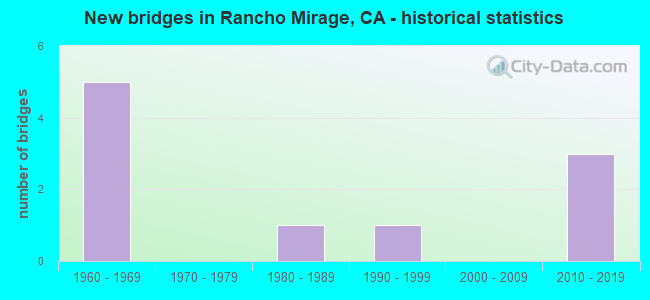
- New bridges - historical statistics
- 51960-1969
- 11980-1989
- 11990-1999
- 32010-2019

- Reconstructed bridges - Historical Statistics
- 21980-1989
- 01990-1999
- 22000-2009


- Bridge Condition - Deck
- 62.5%Good
- 37.5%Fair

- Bridge Condition - Superstructure
- 87.5%Good
- 12.5%Fair

- Bridge Condition - Channel
- 40.0%Excellent
- 60.0%Very good
Find on map >> Show street view
Structure Number: 56 0811, Location: 08-RIV-010-42.97 (Lat: 33.820600, Lng: -116.408889), Route carried "on" structure: City street , Year Built: 2012, Status: Open, Structure Length: 8.95m (29.36ft), Average Daily Traffic: 14,700 (year 2012), Truck Traffic: 3%, Average Future Daily Traffic: 17,037 (year 2038), Design Load: HS 20+Mod, Features Intersected: INTERSTATE 10, Facility Carried by Structure: BOB HOPE DRIVE
Minimum Vertical Clearance: 30+ m (98+ ft), Kilometerpoint: 0.000, Lanes on structure: 7, Lanes under structure: 8, Owner: State Highway Agency, Approaching Roadway Width: 34.8m (114.2ft), Material/Design: Prestressed concrete continuous, Design/Construction: Box Beam or Girders - Multiple, Number Of Spans In Main Unit: 2, Length of Maximum Span: 46.7m (153.2ft), Curb or Sidewalk Widths: Left: 1.8m (5.9ft), Right: 0.0m, Curb-To-Curb Width: 34.8m (114.2ft), Out-to-Out Width: 37.4m (122.7ft)
Condition: Deck: Good, Superstructure: Good, Substructure: Good, Operating Rating: 54.1 metric tons, Method Used To Determine Operating Rating: Assigned rating based on Load Factor Design (LFD) reported in metric tons, Inventory Rating: 32.4 metric tons, Method Used To Determine Inventory Rating: Assigned rating based on Load Factor Design (LFD) reported in metric tons, Structural Evaluation: Better than present minimum criteria, Deck Geometry: Superior to present desirable criteria, Underclear: Equal to present minimum criteria, Approach Roadway Alignment: Equal to present desirable criteria, Designated Inspection Frequency: Every 24 months, Inspection Date: October 2021, Deck Structure Type: Concrete Cast-file-Place
Find on map >> Show street view
Structure Number: 56C0052, Location: 0.1 MI. W/O ROUTE 10 FWY (Lat: 33.816261, Lng: -116.406814), Route carried "on" structure: County highway , Year Built: 1962, Status: Open, Structure Length: 6.80m (22.31ft), Average Daily Traffic: 26,402 (year 2013), Truck Traffic: 1%, Average Future Daily Traffic: 55,210 (year 2044), Design Load: HS 20+Mod, Features Intersected: UP RR & AMTRAK, Facility Carried by Structure: RAMON ROAD
Minimum Vertical Clearance: 30+ m (98+ ft), Kilometerpoint: 0.000, Lanes on structure: 2, Owner: County Highway Agency, Approaching Roadway Width: 11.9m (39.0ft), Skew: 5 degrees, Material/Design: Prestressed concrete continuous, Design/Construction: Stringer/Multi-beam, Number Of Spans In Main Unit: 3, Length of Maximum Span: 23.8m (78.1ft), Curb or Sidewalk Widths: Left: 0.0m, Right: 1.5m (4.9ft), Curb-To-Curb Width: 12.1m (39.7ft), Out-to-Out Width: 14.6m (47.9ft)
Condition: Deck: Fair, Superstructure: Good, Substructure: Good, Operating Rating: 37.9 metric tons, Method Used To Determine Operating Rating: Load and Resistance Factor Rating (LRFR) rating reported by rating factor(RF) method using HL-93 loadings, Inventory Rating: 25.9 metric tons, Method Used To Determine Inventory Rating: Load and Resistance Factor Rating (LRFR) rating reported by rating factor(RF) method using HL-93 loadings, Structural Evaluation: Equal to present minimum criteria, Deck Geometry: Somewhat better than minimum adequacy, Underclear: Better than present minimum criteria, Approach Roadway Alignment: Equal to present desirable criteria, Designated Inspection Frequency: Every 24 months, Inspection Date: Febuary 2022, Deck Structure Type: Concrete Cast-file-Place
Find on map >> Show street view
Structure Number: 56C0068, Location: 0.6 MI. N/O ST RTE 111 (Lat: 33.744303, Lng: -116.408075), Route carried "on" structure: City street , Year Built: 1969, Year Reconstructed: 1985, Status: Open, Structure Length: 15.61m (51.21ft), Average Daily Traffic: 21,000 (year 2018), Truck Traffic: 1%, Average Future Daily Traffic: 43,711 (year 2037), Design Load: HS 20, Features Intersected: WHITEWATER RIVER, Facility Carried by Structure: BOB HOPE DRIVE
Minimum Vertical Clearance: 30+ m (98+ ft), Kilometerpoint: 0.000, Lanes on structure: 4, Owner: City or Municipal Highway Agency, Approaching Roadway Width: 22.6m (74.1ft), Skew: 3 degrees, Material/Design: Concrete continuous, Design/Construction: Tee Beam, Number Of Spans In Main Unit: 8, Length of Maximum Span: 20.7m (67.9ft), Curb or Sidewalk Widths: Left: 0.0m, Right: 1.5m (4.9ft), Curb-To-Curb Width: 17.1m (56.1ft), Out-to-Out Width: 19.4m (63.6ft)
Condition: Deck: Good, Superstructure: Good, Substructure: Good, Channel: Very good, Operating Rating: 67.7 metric tons, Method Used To Determine Operating Rating: Load Factor (LF), Inventory Rating: 40.8 metric tons, Method Used To Determine Inventory Rating: Load Factor (LF), Structural Evaluation: Better than present minimum criteria, Deck Geometry: Somewhat better than minimum adequacy, Waterway Adequacy: Equal to present desirable criteria, Approach Roadway Alignment: Equal to present desirable criteria, Designated Inspection Frequency: Every 48 months, Inspection Date: November 2018, Deck Structure Type: Concrete Cast-file-Place, Wearing Surface/Protective System: Wearing Surface: Bituminous
Find on map >> Show street view
Structure Number: 56C0495, Location: 0.3 MI. E/O ROUTE 111 HWY (Lat: 33.757594, Lng: -116.429669), Route carried "on" structure: City street , Year Built: 1998, Status: Open, Structure Length: 4.70m (15.42ft), Average Daily Traffic: 10,000 (year 2017), Truck Traffic: 1%, Average Future Daily Traffic: 10,338 (year 2035), Features Intersected: WHITEWATER RIVER, Facility Carried by Structure: COUNTRY CLUB DRIVE
Minimum Vertical Clearance: 30+ m (98+ ft), Kilometerpoint: 0.000, Lanes on structure: 4, Owner: City or Municipal Highway Agency, Approaching Roadway Width: 20.1m (65.9ft), Skew: 4 degrees, Material/Design: Concrete continuous, Design/Construction: Culvert, Number Of Spans In Main Unit: 11, Length of Maximum Span: 3.9m (12.8ft), Curb-To-Curb Width: 19.4m (63.6ft), Out-to-Out Width: 20.0m (65.6ft)
Condition: Channel: Excellent, Culverts: Satisfactory, Operating Rating: 54.1 metric tons, Method Used To Determine Operating Rating: Field evaluation and documented engineering judgment, Inventory Rating: 32.4 metric tons, Method Used To Determine Inventory Rating: Field evaluation and documented engineering judgment, Structural Evaluation: Equal to present minimum criteria, Deck Geometry: Better than present minimum criteria, Waterway Adequacy: Equal to present desirable criteria, Approach Roadway Alignment: Equal to present desirable criteria, Designated Inspection Frequency: Every 48 months, Inspection Date: November 2018
Find on map >> Show street view
Structure Number: 56C0502, Location: 4.5 MI. SE/O DATE PALM DR (Lat: 33.732092, Lng: -116.405203), Route carried "on" structure: City street , Year Built: 1964, Year Reconstructed: 1988, Status: Open, Structure Length: 1.78m (5.84ft), Average Daily Traffic: 35,000 (year 2017), Truck Traffic: 7%, Average Future Daily Traffic: 69,148 (year 2037), Design Load: HS 20, Features Intersected: RANCHO MIRAGE CHANNEL, Facility Carried by Structure: PALM CANYON DRIVE
Minimum Vertical Clearance: 30+ m (98+ ft), Kilometerpoint: 0.000, Lanes on structure: 6, Base Highway Network: Yes, Owner: City or Municipal Highway Agency, Approaching Roadway Width: 23.0m (75.5ft), Skew: 23 degrees, Material/Design: Concrete continuous, Design/Construction: Slab, Number Of Spans In Main Unit: 2, Length of Maximum Span: 8.3m (27.2ft), Curb or Sidewalk Widths: Left: 1.6m (5.2ft), Right: 1.6m (5.2ft), Curb-To-Curb Width: 23.0m (75.5ft), Out-to-Out Width: 30.5m (100.1ft)
Condition: Deck: Good, Superstructure: Good, Substructure: Good, Channel: Excellent, Operating Rating: 60.3 metric tons, Method Used To Determine Operating Rating: Load Factor (LF), Inventory Rating: 36.3 metric tons, Method Used To Determine Inventory Rating: Load Factor (LF), Structural Evaluation: Better than present minimum criteria, Deck Geometry: Meets minimum limits, Waterway Adequacy: Equal to present desirable criteria, Approach Roadway Alignment: Equal to present desirable criteria, Designated Inspection Frequency: Every 48 months, Inspection Date: November 2020, Deck Structure Type: Concrete Cast-file-Place, Wearing Surface/Protective System: Wearing Surface: Bituminous
Find on map >> Show street view
Structure Number: 56C0503, Location: 3.0 MI. SE/O DATE PALM DR (Lat: 33.747342, Lng: -116.420817), Route carried "on" structure: City street , Year Built: 1964, Year Reconstructed: 2000, Status: Open, Structure Length: 2.62m (8.60ft), Average Daily Traffic: 35,000 (year 2017), Truck Traffic: 5%, Average Future Daily Traffic: 69,148 (year 2037), Design Load: HS 20, Features Intersected: W RANCHO MIRAGE CHANNEL, Facility Carried by Structure: PALM CANYON DRIVE
Minimum Vertical Clearance: 30+ m (98+ ft), Kilometerpoint: 0.000, Lanes on structure: 6, Base Highway Network: Yes, Owner: City or Municipal Highway Agency, Approaching Roadway Width: 22.1m (72.5ft), Skew: 20 degrees, Material/Design: Concrete continuous, Design/Construction: Slab, Number Of Spans In Main Unit: 2, Length of Maximum Span: 12.8m (42.0ft), Curb or Sidewalk Widths: Left: 1.8m (5.9ft), Right: 1.8m (5.9ft), Curb-To-Curb Width: 22.1m (72.5ft), Out-to-Out Width: 30.3m (99.4ft)
Condition: Deck: Good, Superstructure: Good, Substructure: Good, Channel: Very good, Operating Rating: 69.0 metric tons, Method Used To Determine Operating Rating: Load Factor (LF), Inventory Rating: 41.5 metric tons, Method Used To Determine Inventory Rating: Load Factor (LF), Structural Evaluation: Better than present minimum criteria, Deck Geometry: High priority of corrective action, Waterway Adequacy: Equal to present desirable criteria, Approach Roadway Alignment: Equal to present desirable criteria, Designated Inspection Frequency: Every 48 months, Inspection Date: November 2018, Deck Structure Type: Concrete Cast-file-Place, Wearing Surface/Protective System: Wearing Surface: Bituminous
Find on map >> Show street view
Structure Number: 56C0504, Location: 2.3 MI. SE/O DATE PALM DR (Lat: 33.752222, Lng: -116.429036), Route carried "on" structure: City street , Year Built: 1964, Year Reconstructed: 2000, Status: Open, Structure Length: 2.38m (7.81ft), Average Daily Traffic: 37,000 (year 2017), Truck Traffic: 5%, Average Future Daily Traffic: 68,232 (year 2035), Design Load: HS 20, Features Intersected: THUNDERBIRD CHANNEL, Facility Carried by Structure: PALM CANYON DRIVE
Minimum Vertical Clearance: 30+ m (98+ ft), Kilometerpoint: 0.000, Lanes on structure: 6, Base Highway Network: Yes, Owner: City or Municipal Highway Agency, Approaching Roadway Width: 23.0m (75.5ft), Skew: 20 degrees, Material/Design: Concrete continuous, Design/Construction: Slab, Number Of Spans In Main Unit: 2, Length of Maximum Span: 11.3m (37.1ft), Curb-To-Curb Width: 23.0m (75.5ft), Out-to-Out Width: 28.1m (92.2ft)
Condition: Deck: Good, Superstructure: Good, Substructure: Good, Channel: Very good, Operating Rating: 54.1 metric tons, Method Used To Determine Operating Rating: Assigned rating based on Load Factor Design (LFD) reported in metric tons, Inventory Rating: 32.4 metric tons, Method Used To Determine Inventory Rating: Assigned rating based on Load Factor Design (LFD) reported in metric tons, Structural Evaluation: Better than present minimum criteria, Deck Geometry: Meets minimum limits, Waterway Adequacy: Equal to present minimum criteria, Approach Roadway Alignment: Equal to present desirable criteria, Designated Inspection Frequency: Every 48 months, Inspection Date: November 2018, Deck Structure Type: Concrete Cast-file-Place, Wearing Surface/Protective System: Wearing Surface: Bituminous
Find on map >> Show street view
Structure Number: 56C0514, Location: 0.1 M N/O RAMON ROAD (Lat: 33.817989, Lng: -116.410333), Route carried "on" structure: County highway , Year Built: 2012, Status: Open, Structure Length: 5.71m (18.73ft), Average Daily Traffic: 18,954 (year 2013), Truck Traffic: 11%, Average Future Daily Traffic: 21,759 (year 2040), Design Load: HS 20+Mod, Features Intersected: UP RR & AMTRAK, Facility Carried by Structure: BOB HOPE DRIVE
Minimum Vertical Clearance: 30+ m (98+ ft), Kilometerpoint: 0.000, Lanes on structure: 6, Owner: County Highway Agency, Approaching Roadway Width: 30.2m (99.1ft), Skew: 29 degrees, Material/Design: Prestressed concrete continuous, Design/Construction: Slab, Number Of Spans In Main Unit: 3, Length of Maximum Span: 21.2m (69.6ft), Curb or Sidewalk Widths: Left: 1.8m (5.9ft), Right: 0.0m, Curb-To-Curb Width: 34.8m (114.2ft), Out-to-Out Width: 37.3m (122.4ft)
Condition: Deck: Fair, Superstructure: Fair, Substructure: Good, Operating Rating: 54.1 metric tons, Method Used To Determine Operating Rating: Assigned rating based on Load Factor Design (LFD) reported in metric tons, Inventory Rating: 32.4 metric tons, Method Used To Determine Inventory Rating: Assigned rating based on Load Factor Design (LFD) reported in metric tons, Structural Evaluation: Somewhat better than minimum adequacy, Deck Geometry: Superior to present desirable criteria, Underclear: Equal to present minimum criteria, Approach Roadway Alignment: Better than present minimum criteria, Designated Inspection Frequency: Every 24 months, Inspection Date: March 2021, Deck Structure Type: Concrete Cast-file-Place
Find on map >> Show street view
Structure Number: 56C0573, Location: 1.5 MI W/ BOB HOPE DR. (Lat: 33.803319, Lng: -116.432472), Route carried "on" structure: City street , Year Built: 1988, Status: Open, Structure Length: 1.77m (5.81ft), Average Daily Traffic: 19,000 (year 2017), Truck Traffic: 1%, Average Future Daily Traffic: 14,031 (year 2037), Design Load: HS 20+Mod, Features Intersected: MISSION HILLS DR NORTH, Facility Carried by Structure: DINAH SHORE DRIVE
Minimum Vertical Clearance: 30+ m (98+ ft), Kilometerpoint: 0.000, Lanes on structure: 4, Lanes under structure: 2, Owner: City or Municipal Highway Agency, Approaching Roadway Width: 17.8m (58.4ft), Skew: 11 degrees, Material/Design: Concrete, Design/Construction: Box Beam or Girders - Multiple, Number Of Spans In Main Unit: 1, Length of Maximum Span: 16.8m (55.1ft), Curb or Sidewalk Widths: Left: 2.4m (7.9ft), Right: 2.4m (7.9ft), Curb-To-Curb Width: 18.2m (59.7ft), Out-to-Out Width: 28.6m (93.8ft)
Condition: Deck: Fair, Superstructure: Good, Substructure: Good, Operating Rating: 54.1 metric tons, Method Used To Determine Operating Rating: Assigned rating based on Load Factor Design (LFD) reported in metric tons, Inventory Rating: 32.4 metric tons, Method Used To Determine Inventory Rating: Assigned rating based on Load Factor Design (LFD) reported in metric tons, Structural Evaluation: Better than present minimum criteria, Deck Geometry: Somewhat better than minimum adequacy, Underclear: High priority of corrective action, Approach Roadway Alignment: Equal to present minimum criteria, Designated Inspection Frequency: Every 24 months, Inspection Date: November 2020, Deck Structure Type: Concrete Cast-file-Place
Find on map >> Show street view
Structure Number: 56 0811, Location: 08-RIV-010-42.97 (Lat: 33.820600, Lng: -116.408889), Route carried "under" structure: Interstate 10, Year Built: 2012, Structure Length: 0. m, Average Daily Traffic: 100,000 (year 2012), Truck Traffic: 16%, Features Intersected: INTERSTATE 10, Facility Carried by Structure: BOB HOPE DRIVE
Minimum Vertical Clearance: 7.33m (24.05ft), Kilometerpoint: 42.970, Lanes on structure: 7, Lanes under structure: 8, Material/Design: Prestressed concrete continuous, Design/Construction: Box Beam or Girders - Multiple, Length of Maximum Span: 46.7m (153.2ft)