Bridge Statistics for Prunedale, California (CA)
Condition, Traffic, Stress, Structural Evaluation, Project Costs
- National Bridge Inventory (NBI) Statistics
- 29Number of bridges
- 302ft / 91.6mTotal length
- 584,305Total average daily traffic
- 73,579Total average daily truck traffic
- National Bridge Inventory (NBI) Registered Bridges for Prunedale
- No street view available for this location
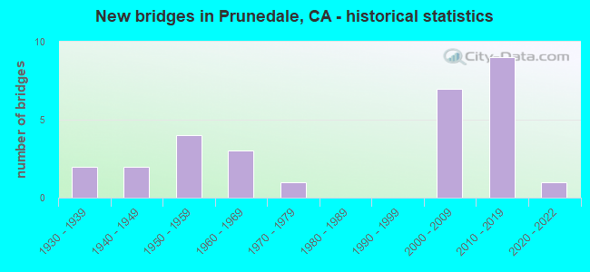
- New bridges - historical statistics
- 21930-1939
- 21940-1949
- 41950-1959
- 31960-1969
- 11970-1979
- 72000-2009
- 92010-2019
- 12020-2022


- Bridge Condition - Deck
- 78.9%Good
- 5.3%Satisfactory
- 15.8%Fair

- Bridge Condition - Superstructure
- 75.0%Good
- 10.0%Satisfactory
- 15.0%Fair

- Bridge Condition - Substructure
- 80.0%Good
- 5.0%Satisfactory
- 15.0%Fair

- Bridge Condition - Channel
- 66.7%Excellent
- 16.7%Good
- 16.7%Satisfactory
Find on map >> Show street view
Structure Number: 43 0031E, Location: 05-SBT-156-0.01 (Lat: 36.862175, Lng: -121.580119), Route carried "on" structure: Ramp State highway 156, Year Built: 1958, Status: Open, Structure Length: 9.93m (32.58ft), Average Daily Traffic: 13,000 (year 2009), Truck Traffic: 16%, Average Future Daily Traffic: 15,426 (year 2042), Design Load: HS 20, Features Intersected: US HWY 101 (@PM 3.02)
Minimum Vertical Clearance: 30+ m (98+ ft), Kilometerpoint: 0.010, Lanes on structure: 2, Lanes under structure: 4, Base Highway Network: Yes, Owner: State Highway Agency, Approaching Roadway Width: 11.9m (39.0ft), Skew: 3 degrees, Material/Design: Steel, Design/Construction: Stringer/Multi-beam, Number Of Spans In Main Unit: 6, Length of Maximum Span: 20.9m (68.6ft), Curb-To-Curb Width: 8.5m (27.9ft), Out-to-Out Width: 9.6m (31.5ft)
Condition: Deck: Fair, Superstructure: Good, Substructure: Good, Operating Rating: 66.1 metric tons, Method Used To Determine Operating Rating: Load Factor (LF), Inventory Rating: 39.5 metric tons, Method Used To Determine Inventory Rating: Load Factor (LF), Structural Evaluation: Better than present minimum criteria, Deck Geometry: High priority of corrective action, Underclear: High priority of corrective action, Approach Roadway Alignment: Equal to present desirable criteria, Designated Inspection Frequency: Every 24 months, Other Special Inspection Frequency: Every 48 months, Inspection Date: June 2020, Other Special Inspection Date: June 2021, Deck Structure Type: Concrete Cast-file-Place, Wearing Surface/Protective System: Wearing Surface: Integral Concrete
Find on map >> Show street view
Structure Number: 43C0053, Location: EAST LITTLE MERRILL RD (Lat: 36.854394, Lng: -121.589753), Route carried "on" structure: County highway , Year Built: 1930, Status: Open, Structure Length: 0.70m (2.30ft), Average Daily Traffic: 1,200 (year 2010), Truck Traffic: 5%, Average Future Daily Traffic: 1,353 (year 2041), Features Intersected: PINACATE ROCK CREEK, Facility Carried by Structure: ROCKS ROAD
Minimum Vertical Clearance: 30+ m (98+ ft), Kilometerpoint: 0.000, Lanes on structure: 2, Owner: County Highway Agency, Approaching Roadway Width: 4.9m (16.1ft), Skew: 3 degrees, Material/Design: Concrete, Design/Construction: Tee Beam, Number Of Spans In Main Unit: 1, Length of Maximum Span: 6.1m (20.0ft), Curb or Sidewalk Widths: Left: 0.4m (1.3ft), Right: 0.4m (1.3ft), Curb-To-Curb Width: 5.3m (17.4ft), Out-to-Out Width: 6.1m (20.0ft)
Condition: Deck: Good, Superstructure: Good, Substructure: Fair, Channel: Good, Operating Rating: 28.5 metric tons, Method Used To Determine Operating Rating: Field evaluation and documented engineering judgment, Inventory Rating: 17.2 metric tons, Method Used To Determine Inventory Rating: Field evaluation and documented engineering judgment, Structural Evaluation: Meets minimum limits, Deck Geometry: High priority of replacement, Waterway Adequacy: Somewhat better than minimum adequacy, Approach Roadway Alignment: Equal to present desirable criteria, Designated Inspection Frequency: Every 24 months, Inspection Date: January 2021, Deck Structure Type: Concrete Cast-file-Place, Wearing Surface/Protective System: Wearing Surface: Bituminous
Find on map >> Show street view
Structure Number: 44 0107, Location: 05-MON-156-T5.17 (Lat: 36.789353, Lng: -121.667964), Route carried "on" structure: State highway 156, Year Built: 1969, Status: Open, Structure Length: 6.43m (21.10ft), Average Daily Traffic: 28,750 (year 2011), Truck Traffic: 9%, Average Future Daily Traffic: 39,000 (year 2038), Design Load: HS 20+Mod, Features Intersected: US HWY 101 (@PM 95.44)
Minimum Vertical Clearance: 30+ m (98+ ft), Kilometerpoint: 5.170, Lanes on structure: 3, Lanes under structure: 6, Base Highway Network: Yes (Inventory Route: 1, Subroute: 1), Owner: State Highway Agency, Approaching Roadway Width: 16.5m (54.1ft), Skew: 23 degrees, Material/Design: Prestressed concrete continuous, Design/Construction: Box Beam or Girders - Multiple, Number Of Spans In Main Unit: 2, Length of Maximum Span: 33.5m (109.9ft), Curb-To-Curb Width: 16.5m (54.1ft), Out-to-Out Width: 17.1m (56.1ft)
Condition: Deck: Good, Superstructure: Good, Substructure: Good, Operating Rating: 69.0 metric tons, Method Used To Determine Operating Rating: Load Factor (LF), Inventory Rating: 32.4 metric tons, Method Used To Determine Inventory Rating: Load Factor (LF), Structural Evaluation: Better than present minimum criteria, Deck Geometry: Better than present minimum criteria, Underclear: Equal to present minimum criteria, Approach Roadway Alignment: Equal to present desirable criteria, Designated Inspection Frequency: Every 24 months, Inspection Date: August 2020, Deck Structure Type: Concrete Cast-file-Place
Find on map >> Show street view
Structure Number: 44 0271, Location: 05-MON-101-96.14 (Lat: 36.799525, Lng: -121.664439), Route carried "on" structure: Ramp US 101, Year Built: 2004, Year Reconstructed: 2012, Status: Open, Structure Length: 5.89m (19.32ft), Average Daily Traffic: 11,900 (year 2009), Truck Traffic: 5%, Average Future Daily Traffic: 36,522 (year 2042), Design Load: HL 93, Features Intersected: U.S. HIGHWAY 101, Facility Carried by Structure: SAN MIGUEL CANYON
Minimum Vertical Clearance: 30+ m (98+ ft), Kilometerpoint: 96.140, Lanes on structure: 3, Lanes under structure: 4, Owner: State Highway Agency, Approaching Roadway Width: 15.7m (51.5ft), Skew: 2 degrees, Material/Design: Prestressed concrete continuous, Design/Construction: Box Beam or Girders - Multiple, Number Of Spans In Main Unit: 2, Length of Maximum Span: 33.4m (109.6ft), Curb-To-Curb Width: 15.7m (51.5ft), Out-to-Out Width: 16.6m (54.5ft)
Condition: Deck: Satisfactory, Superstructure: Good, Substructure: Good, Operating Rating: 42.1 metric tons, Method Used To Determine Operating Rating: Assigned ratings based on Load and Resistance Factor Design (LRFD) reported by rating factor (RF) using HL93 loadings, Inventory Rating: 32.4 metric tons, Method Used To Determine Inventory Rating: Assigned ratings based on Load and Resistance Factor Design (LRFD) reported by rating factor (RF) using HL93 loadings, Structural Evaluation: Better than present minimum criteria, Deck Geometry: Superior to present desirable criteria, Underclear: High priority of corrective action, Approach Roadway Alignment: Equal to present desirable criteria, Designated Inspection Frequency: Every 24 months, Inspection Date: June 2020, Deck Structure Type: Concrete Cast-file-Place
Find on map >> Show street view
Structure Number: 44 0276Y, Location: 05-MON-156-T5.10 (Lat: 36.789981, Lng: -121.668861), Route carried "on" structure: Ramp State highway 156, Year Built: 2005, Status: Open, Structure Length: 2.16m (7.09ft), Average Daily Traffic: 5,000 (year 2016), Truck Traffic: 15%, Average Future Daily Traffic: 7,580 (year 2042), Design Load: HS 20+Mod, Features Intersected: S101-W156 CONNECTOR RAMP, Facility Carried by Structure: PRUNEDALE OC
Minimum Vertical Clearance: 30+ m (98+ ft), Kilometerpoint: 5.100, Lanes on structure: 3, Lanes under structure: 2, Owner: State Highway Agency, Approaching Roadway Width: 17.1m (56.1ft), Skew: 1 degrees, Material/Design: Concrete, Design/Construction: Box Beam or Girders - Multiple, Number Of Spans In Main Unit: 1, Length of Maximum Span: 19.8m (65.0ft), Curb-To-Curb Width: 15.6m (51.2ft), Out-to-Out Width: 16.6m (54.5ft)
Condition: Deck: Fair, Superstructure: Satisfactory, Substructure: Good, Operating Rating: 54.1 metric tons, Method Used To Determine Operating Rating: Assigned rating based on Load Factor Design (LFD) reported in metric tons, Inventory Rating: 32.4 metric tons, Method Used To Determine Inventory Rating: Assigned rating based on Load Factor Design (LFD) reported in metric tons, Structural Evaluation: Equal to present minimum criteria, Deck Geometry: Superior to present desirable criteria, Underclear: Somewhat better than minimum adequacy, Approach Roadway Alignment: Equal to present desirable criteria, Designated Inspection Frequency: Every 24 months, Inspection Date: August 2020, Deck Structure Type: Concrete Cast-file-Place
Find on map >> Show street view
Structure Number: 44 0277F, Location: 05-MON-101-95.35 (Lat: 36.788822, Lng: -121.670939), Route carried "on" structure: Ramp US 101, Year Built: 2004, Status: Open, Structure Length: 2.65m (8.69ft), Average Daily Traffic: 13,225 (year 2010), Truck Traffic: 8%, Average Future Daily Traffic: 16,425 (year 2042), Design Load: HS 20+Mod, Features Intersected: PRUNEDALE SOUTH ROAD
Minimum Vertical Clearance: 30+ m (98+ ft), Kilometerpoint: 95.350, Lanes on structure: 1, Lanes under structure: 2, Base Highway Network: Yes (Inventory Route: 1, Subroute: 1), Owner: State Highway Agency, Approaching Roadway Width: 7.1m (23.3ft), Material/Design: Concrete, Design/Construction: Box Beam or Girders - Multiple, Number Of Spans In Main Unit: 1, Length of Maximum Span: 26.0m (85.3ft), Curb-To-Curb Width: 7.1m (23.3ft), Out-to-Out Width: 8.1m (26.6ft)
Condition: Deck: Good, Superstructure: Good, Substructure: Good, Operating Rating: 54.1 metric tons, Method Used To Determine Operating Rating: Assigned rating based on Load Factor Design (LFD) reported in metric tons, Inventory Rating: 32.4 metric tons, Method Used To Determine Inventory Rating: Assigned rating based on Load Factor Design (LFD) reported in metric tons, Structural Evaluation: Better than present minimum criteria, Deck Geometry: Equal to present minimum criteria, Underclear: Somewhat better than minimum adequacy, Approach Roadway Alignment: Equal to present desirable criteria, Designated Inspection Frequency: Every 24 months, Inspection Date: June 2020, Deck Structure Type: Concrete Cast-file-Place
Find on map >> Show street view
Structure Number: 44 0278, Location: 05-MON-156-T5.00 (Lat: 36.788636, Lng: -121.670961), Route carried "on" structure: State highway 156, Year Built: 2005, Status: Open, Structure Length: 3.21m (10.53ft), Average Daily Traffic: 29,750 (year 2010), Truck Traffic: 15%, Average Future Daily Traffic: 59,945 (year 2038), Design Load: HS 20+Mod, Features Intersected: PRUNEDALE SOUTH ROAD
Minimum Vertical Clearance: 30+ m (98+ ft), Kilometerpoint: 5.000, Lanes on structure: 3, Lanes under structure: 2, Base Highway Network: Yes (Inventory Route: 1, Subroute: 1), Owner: State Highway Agency, Approaching Roadway Width: 16.0m (52.5ft), Material/Design: Prestressed concrete, Design/Construction: Box Beam or Girders - Single/Spread, Number Of Spans In Main Unit: 1, Length of Maximum Span: 30.6m (100.4ft), Curb-To-Curb Width: 14.8m (48.6ft), Out-to-Out Width: 15.8m (51.8ft)
Condition: Deck: Good, Superstructure: Good, Substructure: Good, Operating Rating: 54.1 metric tons, Method Used To Determine Operating Rating: Assigned rating based on Load Factor Design (LFD) reported in metric tons, Inventory Rating: 32.4 metric tons, Method Used To Determine Inventory Rating: Assigned rating based on Load Factor Design (LFD) reported in metric tons, Structural Evaluation: Better than present minimum criteria, Deck Geometry: Equal to present minimum criteria, Underclear: Somewhat better than minimum adequacy, Approach Roadway Alignment: Equal to present desirable criteria, Designated Inspection Frequency: Every 24 months, Inspection Date: August 2020, Deck Structure Type: Concrete Cast-file-Place
Find on map >> Show street view
Structure Number: 44 0283, Location: 05-MON-101-92.19 (Lat: 36.743494, Lng: -121.660658), Route carried "on" structure: Ramp US 101, Year Built: 2013, Status: Open, Structure Length: 6.31m (20.70ft), Average Daily Traffic: 2,000 (year 2014), Truck Traffic: 5%, Average Future Daily Traffic: 3,866 (year 2042), Design Load: HL 93, Features Intersected: US HIGHWAY 101, Facility Carried by Structure: SALA ROAD
Minimum Vertical Clearance: 30+ m (98+ ft), Kilometerpoint: 92.190, Lanes on structure: 4, Lanes under structure: 5, Owner: State Highway Agency, Approaching Roadway Width: 24.0m (78.7ft), Material/Design: Prestressed concrete continuous, Design/Construction: Box Beam or Girders - Multiple, Number Of Spans In Main Unit: 2, Length of Maximum Span: 36.1m (118.4ft), Curb-To-Curb Width: 24.0m (78.7ft), Out-to-Out Width: 24.9m (81.7ft)
Condition: Deck: Good, Superstructure: Satisfactory, Substructure: Good, Operating Rating: 42.1 metric tons, Method Used To Determine Operating Rating: Assigned ratings based on Load and Resistance Factor Design (LRFD) reported by rating factor (RF) using HL93 loadings, Inventory Rating: 32.4 metric tons, Method Used To Determine Inventory Rating: Assigned ratings based on Load and Resistance Factor Design (LRFD) reported by rating factor (RF) using HL93 loadings, Structural Evaluation: Equal to present minimum criteria, Deck Geometry: Superior to present desirable criteria, Underclear: Somewhat better than minimum adequacy, Approach Roadway Alignment: Equal to present desirable criteria, Designated Inspection Frequency: Every 24 months, Inspection Date: June 2020, Deck Structure Type: Concrete Cast-file-Place
Find on map >> Show street view
Structure Number: 44 0284, Location: 05-MON-101-94.07 (Lat: 36.769778, Lng: -121.669322), Route carried "on" structure: County highway , Year Built: 2013, Status: Open, Structure Length: 5.50m (18.04ft), Average Daily Traffic: 2,000 (year 2014), Truck Traffic: 5%, Average Future Daily Traffic: 3,866 (year 2042), Design Load: HL 93, Features Intersected: US HIGHWAY 101, Facility Carried by Structure: PRUNEDALE SOUTH RD
Minimum Vertical Clearance: 30+ m (98+ ft), Kilometerpoint: 0.000, Lanes on structure: 2, Lanes under structure: 4, Owner: State Highway Agency, Approaching Roadway Width: 12.0m (39.4ft), Skew: 2 degrees, Material/Design: Prestressed concrete, Design/Construction: Box Beam or Girders - Multiple, Number Of Spans In Main Unit: 1, Length of Maximum Span: 54.1m (177.5ft), Curb or Sidewalk Widths: Left: 1.5m (4.9ft), Right: 1.5m (4.9ft), Curb-To-Curb Width: 12.0m (39.4ft), Out-to-Out Width: 15.6m (51.2ft)
Condition: Deck: Good, Superstructure: Good, Substructure: Good, Operating Rating: 42.1 metric tons, Method Used To Determine Operating Rating: Assigned ratings based on Load and Resistance Factor Design (LRFD) reported by rating factor (RF) using HL93 loadings, Inventory Rating: 32.4 metric tons, Method Used To Determine Inventory Rating: Assigned ratings based on Load and Resistance Factor Design (LRFD) reported by rating factor (RF) using HL93 loadings, Structural Evaluation: Better than present minimum criteria, Deck Geometry: Equal to present minimum criteria, Underclear: Meets minimum limits, Approach Roadway Alignment: Equal to present desirable criteria, Designated Inspection Frequency: Every 24 months, Inspection Date: June 2020, Deck Structure Type: Concrete Cast-file-Place
Find on map >> Show street view
Structure Number: 44 0285S, Location: 05-MON-101-98.25 (Lat: 36.817142, Lng: -121.634386), Route carried "on" structure: Ramp US 101, Year Built: 2013, Status: Open, Structure Length: 15.40m (50.52ft), Average Daily Traffic: 2,000 (year 2014), Truck Traffic: 16%, Average Future Daily Traffic: 3,866 (year 2042), Design Load: HL 93, Features Intersected: WETLAND
Minimum Vertical Clearance: 30+ m (98+ ft), Kilometerpoint: 98.250, Lanes on structure: 1, Owner: State Highway Agency, Approaching Roadway Width: 7.2m (23.6ft), Material/Design: Prestressed concrete continuous, Design/Construction: Box Beam or Girders - Multiple, Number Of Spans In Main Unit: 4, Length of Maximum Span: 44.0m (144.4ft), Curb-To-Curb Width: 7.2m (23.6ft), Out-to-Out Width: 8.1m (26.6ft)
Condition: Deck: Good, Superstructure: Good, Substructure: Good, Operating Rating: 42.1 metric tons, Method Used To Determine Operating Rating: Assigned ratings based on Load and Resistance Factor Design (LRFD) reported by rating factor (RF) using HL93 loadings, Inventory Rating: 32.4 metric tons, Method Used To Determine Inventory Rating: Assigned ratings based on Load and Resistance Factor Design (LRFD) reported by rating factor (RF) using HL93 loadings, Structural Evaluation: Better than present minimum criteria, Deck Geometry: Equal to present minimum criteria, Approach Roadway Alignment: Equal to present desirable criteria, Designated Inspection Frequency: Every 24 months, Inspection Date: June 2020, Deck Structure Type: Concrete Cast-file-Place
Find on map >> Show street view
Structure Number: 44 0286, Location: 05-MON-101-98.37 (Lat: 36.818575, Lng: -121.633275), Route carried "on" structure: County highway , Year Built: 2014, Status: Open, Structure Length: 5.74m (18.83ft), Average Daily Traffic: 4,528 (year 2014), Truck Traffic: 5%, Average Future Daily Traffic: 8,743 (year 2042), Design Load: HL 93, Features Intersected: U.S. HIGHWAY 101, Facility Carried by Structure: CRAZY HORSE CANYON
Minimum Vertical Clearance: 30+ m (98+ ft), Kilometerpoint: 0.000, Lanes on structure: 3, Lanes under structure: 4, Owner: State Highway Agency, Approaching Roadway Width: 20.4m (66.9ft), Skew: 1 degrees, Material/Design: Prestressed concrete continuous, Design/Construction: Box Beam or Girders - Multiple, Number Of Spans In Main Unit: 2, Length of Maximum Span: 30.6m (100.4ft), Curb or Sidewalk Widths: Left: 3.0m (9.8ft), Right: 3.0m (9.8ft), Curb-To-Curb Width: 20.4m (66.9ft), Out-to-Out Width: 27.0m (88.6ft)
Condition: Deck: Good, Superstructure: Good, Substructure: Good, Operating Rating: 42.1 metric tons, Method Used To Determine Operating Rating: Assigned ratings based on Load and Resistance Factor Design (LRFD) reported by rating factor (RF) using HL93 loadings, Inventory Rating: 32.4 metric tons, Method Used To Determine Inventory Rating: Assigned ratings based on Load and Resistance Factor Design (LRFD) reported by rating factor (RF) using HL93 loadings, Structural Evaluation: Better than present minimum criteria, Deck Geometry: Superior to present desirable criteria, Underclear: Meets minimum limits, Approach Roadway Alignment: Equal to present desirable criteria, Designated Inspection Frequency: Every 24 months, Inspection Date: June 2020, Deck Structure Type: Concrete Cast-file-Place
Find on map >> Show street view
Structure Number: 44 0288Y, Location: 05-MON-000-0.00 (Lat: 36.817450, Lng: -121.631731), Route carried "on" structure: County highway , Year Built: 2013, Status: Open, Structure Length: 14.50m (47.57ft), Average Daily Traffic: 4,528 (year 2014), Truck Traffic: 5%, Average Future Daily Traffic: 8,773 (year 2042), Design Load: HL 93, Features Intersected: WETLAND, Facility Carried by Structure: CRAZY HORSE CANYON
Minimum Vertical Clearance: 30+ m (98+ ft), Kilometerpoint: 0.000, Lanes on structure: 2, Owner: State Highway Agency, Approaching Roadway Width: 12.0m (39.4ft), Material/Design: Prestressed concrete continuous, Design/Construction: Box Beam or Girders - Multiple, Number Of Spans In Main Unit: 3, Length of Maximum Span: 58.0m (190.3ft), Curb or Sidewalk Widths: Left: 1.5m (4.9ft), Right: 1.5m (4.9ft), Curb-To-Curb Width: 12.0m (39.4ft), Out-to-Out Width: 15.6m (51.2ft)
Condition: Deck: Good, Superstructure: Good, Substructure: Satisfactory, Channel: Excellent, Operating Rating: 42.1 metric tons, Method Used To Determine Operating Rating: Assigned ratings based on Load and Resistance Factor Design (LRFD) reported by rating factor (RF) using HL93 loadings, Inventory Rating: 32.4 metric tons, Method Used To Determine Inventory Rating: Assigned ratings based on Load and Resistance Factor Design (LRFD) reported by rating factor (RF) using HL93 loadings, Structural Evaluation: Equal to present minimum criteria, Deck Geometry: Somewhat better than minimum adequacy, Waterway Adequacy: Superior to present desirable criteria, Approach Roadway Alignment: Equal to present desirable criteria, Designated Inspection Frequency: Every 24 months, Inspection Date: June 2020, Deck Structure Type: Concrete Cast-file-Place
Find on map >> Show street view
Structure Number: 44 0292, Location: 05-MON-101-100.95 (Lat: 36.853481, Lng: -121.634194), Route carried "on" structure: US 101, Year Built: 1930, Year Reconstructed: 2014, Status: Open, Structure Length: 0.86m (2.82ft), Average Daily Traffic: 59,000 (year 2009), Truck Traffic: 17%, Average Future Daily Traffic: 62,635 (year 2038), Features Intersected: ELKHORN SLOUGH TRIBUTARY
Minimum Vertical Clearance: 30+ m (98+ ft), Kilometerpoint: 100.950, Lanes on structure: 7, Base Highway Network: Yes (Inventory Route: 1, Subroute: 1), Owner: State Highway Agency, Approaching Roadway Width: 25.0m (82.0ft), Skew: 39 degrees, Material/Design: Concrete continuous, Design/Construction: Culvert, Number Of Spans In Main Unit: 3, Length of Maximum Span: 3.0m (9.8ft)
Condition: Channel: Excellent, Culverts: Satisfactory, Operating Rating: 27.2 metric tons, Method Used To Determine Operating Rating: Field evaluation and documented engineering judgment, Inventory Rating: 16.2 metric tons, Method Used To Determine Inventory Rating: Field evaluation and documented engineering judgment, Structural Evaluation: Meets minimum limits, Waterway Adequacy: Superior to present desirable criteria, Approach Roadway Alignment: Equal to present desirable criteria, Designated Inspection Frequency: Every 24 months, Inspection Date: June 2020
Find on map >> Show street view
Structure Number: 44 0293Y, Location: 05-MON-101-101.29 (Lat: 36.855964, Lng: -121.629758), Route carried "on" structure: Ramp US 101, Year Built: 2014, Status: Open, Structure Length: 1.37m (4.49ft), Average Daily Traffic: 2,500 (year 2014), Truck Traffic: 5%, Average Future Daily Traffic: 3,864 (year 2038), Features Intersected: ELKHORN SLOUGH TRIBUTARY
Minimum Vertical Clearance: 30+ m (98+ ft), Kilometerpoint: 101.290, Lanes on structure: 5, Owner: State Highway Agency, Approaching Roadway Width: 10.7m (35.1ft), Material/Design: Concrete continuous, Design/Construction: Culvert, Number Of Spans In Main Unit: 3, Length of Maximum Span: 4.3m (14.1ft)
Condition: Channel: Excellent, Culverts: Satisfactory, Operating Rating: 54.1 metric tons, Method Used To Determine Operating Rating: Field evaluation and documented engineering judgment, Inventory Rating: 32.4 metric tons, Method Used To Determine Inventory Rating: Field evaluation and documented engineering judgment, Structural Evaluation: Equal to present minimum criteria, Waterway Adequacy: Superior to present desirable criteria, Approach Roadway Alignment: Equal to present desirable criteria, Designated Inspection Frequency: Every 24 months, Inspection Date: June 2020
Find on map >> Show street view
Structure Number: 44C0043, Location: 4.7 MI N SH 101 (Lat: 36.858281, Lng: -121.694739), Route carried "on" structure: County highway , Year Built: 1962, Year Reconstructed: 2008, Status: Open, Structure Length: 2.44m (8.01ft), Average Daily Traffic: 18,300 (year 2017), Truck Traffic: 4%, Average Future Daily Traffic: 30,503 (year 2038), Features Intersected: CARNEROS CREEK, Facility Carried by Structure: SAN MIGUEL CANYON
Minimum Vertical Clearance: 30+ m (98+ ft), Kilometerpoint: 0.000, Lanes on structure: 3, Owner: County Highway Agency, Approaching Roadway Width: 15.0m (49.2ft), Skew: 3 degrees, Material/Design: Concrete continuous, Design/Construction: Slab, Number Of Spans In Main Unit: 3, Length of Maximum Span: 9.8m (32.2ft), Curb-To-Curb Width: 15.5m (50.9ft), Out-to-Out Width: 15.7m (51.5ft)
Condition: Deck: Fair, Superstructure: Fair, Substructure: Good, Channel: Excellent, Operating Rating: 54.1 metric tons, Method Used To Determine Operating Rating: Field evaluation and documented engineering judgment, Inventory Rating: 32.4 metric tons, Method Used To Determine Inventory Rating: Field evaluation and documented engineering judgment, Structural Evaluation: Somewhat better than minimum adequacy, Deck Geometry: Equal to present minimum criteria, Waterway Adequacy: Somewhat better than minimum adequacy, Approach Roadway Alignment: Equal to present desirable criteria, Designated Inspection Frequency: Every 24 months, Inspection Date: August 2021, Deck Structure Type: Concrete Cast-file-Place
Find on map >> Show street view
Structure Number: 44C0131, Location: 1 MI N OF CRAZY HORSE RD (Lat: 36.783550, Lng: -121.591639), Route carried "on" structure: County highway , Year Built: 1940, Status: Open, Structure Length: 0.64m (2.10ft), Average Daily Traffic: 630 (year 2015), Truck Traffic: 5%, Average Future Daily Traffic: 752 (year 2038), Features Intersected: GABILAN CREEK, Facility Carried by Structure: SAN JUAN GRADE RD
Minimum Vertical Clearance: 30+ m (98+ ft), Kilometerpoint: 0.000, Lanes on structure: 2, Owner: County Highway Agency, Approaching Roadway Width: 5.2m (17.1ft), Material/Design: Concrete, Design/Construction: Tee Beam, Number Of Spans In Main Unit: 1, Length of Maximum Span: 6.1m (20.0ft), Curb-To-Curb Width: 6.4m (21.0ft), Out-to-Out Width: 7.2m (23.6ft)
Condition: Deck: Good, Superstructure: Fair, Substructure: Good, Channel: Satisfactory, Operating Rating: 27.9 metric tons, Method Used To Determine Operating Rating: Field evaluation and documented engineering judgment, Inventory Rating: 16.8 metric tons, Method Used To Determine Inventory Rating: Field evaluation and documented engineering judgment, Structural Evaluation: Meets minimum limits, Deck Geometry: High priority of corrective action, Waterway Adequacy: Equal to present minimum criteria, Approach Roadway Alignment: Equal to present desirable criteria, Designated Inspection Frequency: Every 24 months, Inspection Date: August 2021, Deck Structure Type: Concrete Cast-file-Place, Wearing Surface/Protective System: Wearing Surface: Bituminous
Find on map >> Show street view
Structure Number: 44C0132, Location: 1.5 MI N CRAZY HORSE RD (Lat: 36.789236, Lng: -121.588825), Route carried "on" structure: County highway , Year Built: 1940, Status: Open, Structure Length: 0.64m (2.10ft), Average Daily Traffic: 630 (year 2015), Truck Traffic: 5%, Average Future Daily Traffic: 752 (year 2038), Features Intersected: N GABILAN CREEK, Facility Carried by Structure: SAN JUAN GRADE RD
Minimum Vertical Clearance: 30+ m (98+ ft), Kilometerpoint: 0.000, Lanes on structure: 2, Owner: County Highway Agency, Approaching Roadway Width: 5.2m (17.1ft), Material/Design: Concrete, Design/Construction: Tee Beam, Number Of Spans In Main Unit: 1, Length of Maximum Span: 6.1m (20.0ft), Curb or Sidewalk Widths: Left: 0.4m (1.3ft), Right: 0.4m (1.3ft), Curb-To-Curb Width: 6.4m (21.0ft), Out-to-Out Width: 7.2m (23.6ft)
Condition: Deck: Good, Superstructure: Good, Substructure: Fair, Channel: Excellent, Operating Rating: 27.9 metric tons, Method Used To Determine Operating Rating: Field evaluation and documented engineering judgment, Inventory Rating: 16.8 metric tons, Method Used To Determine Inventory Rating: Field evaluation and documented engineering judgment, Structural Evaluation: Meets minimum limits, Deck Geometry: High priority of corrective action, Waterway Adequacy: Equal to present minimum criteria, Approach Roadway Alignment: Equal to present desirable criteria, Designated Inspection Frequency: Every 24 months, Inspection Date: August 2021, Deck Structure Type: Concrete Cast-file-Place, Wearing Surface/Protective System: Wearing Surface: Bituminous
Find on map >> Show street view
Structure Number: 44C0136, Location: 0.2 MI S SAN JUAN RD (Lat: 36.855572, Lng: -121.649181), Route carried "on" structure: County highway , Year Built: 1975, Status: Open, Structure Length: 1.30m (4.27ft), Average Daily Traffic: 150 (year 2015), Truck Traffic: 2%, Average Future Daily Traffic: 211 (year 2038), Design Load: HS 20, Features Intersected: CARNEROS CREEK, Facility Carried by Structure: COREY RD
Minimum Vertical Clearance: 30+ m (98+ ft), Kilometerpoint: 0.000, Lanes on structure: 1, Owner: County Highway Agency, Approaching Roadway Width: 4.9m (16.1ft), Material/Design: Concrete, Design/Construction: Tee Beam, Number Of Spans In Main Unit: 1, Length of Maximum Span: 12.4m (40.7ft), Curb-To-Curb Width: 4.9m (16.1ft), Out-to-Out Width: 5.1m (16.7ft)
Condition: Deck: Good, Superstructure: Good, Substructure: Good, Channel: Satisfactory, Operating Rating: 69.3 metric tons, Method Used To Determine Operating Rating: Load and Resistance Factor Rating (LRFR) rating reported by rating factor(RF) method using HL-93 loadings, Inventory Rating: 50.9 metric tons, Method Used To Determine Inventory Rating: Load and Resistance Factor Rating (LRFR) rating reported by rating factor(RF) method using HL-93 loadings, Structural Evaluation: Better than present minimum criteria, Deck Geometry: High priority of replacement, Waterway Adequacy: Equal to present minimum criteria, Approach Roadway Alignment: High priority of corrective action, Designated Inspection Frequency: Every 48 months, Inspection Date: August 2021, Deck Structure Type: Concrete Cast-file-Place
Find on map >> Show street view
Structure Number: 44C0137, Location: 0.25 MI S TARPEY RD (Lat: 36.857583, Lng: -121.684972), Route carried "on" structure: County highway , Year Built: 1950, Status: Open, Structure Length: 1.68m (5.51ft), Average Daily Traffic: 2,800 (year 2017), Truck Traffic: 3%, Average Future Daily Traffic: 5,084 (year 2038), Design Load: HS 20, Features Intersected: CARNEROS CREEK, Facility Carried by Structure: MAHER RD
Minimum Vertical Clearance: 30+ m (98+ ft), Kilometerpoint: 0.000, Lanes on structure: 2, Owner: County Highway Agency, Approaching Roadway Width: 11.0m (36.1ft), Skew: 1 degrees, Material/Design: Steel continuous, Design/Construction: Girder and Floorbeam System, Number Of Spans In Main Unit: 2, Length of Maximum Span: 7.9m (25.9ft), Curb-To-Curb Width: 11.7m (38.4ft), Out-to-Out Width: 11.9m (39.0ft)
Condition: Deck: Good, Superstructure: Good, Substructure: Good, Channel: Excellent, Operating Rating: 24.6 metric tons, Method Used To Determine Operating Rating: Load Factor (LF), Inventory Rating: 14.9 metric tons, Method Used To Determine Inventory Rating: Load Factor (LF), Structural Evaluation: Meets minimum limits, Deck Geometry: Somewhat better than minimum adequacy, Waterway Adequacy: Equal to present minimum criteria, Approach Roadway Alignment: Equal to present minimum criteria, Designated Inspection Frequency: Every 24 months, Other Special Inspection Frequency: Every 48 months, Inspection Date: August 2021, Other Special Inspection Date: August 2019, Deck Structure Type: Closed Grating, Wearing Surface/Protective System: Wearing Surface: Bituminous
Find on map >> Show street view
Structure Number: 44C0138, Location: 0.1 MI S HALL RD (Lat: 36.859797, Lng: -121.707625), Route carried "on" structure: County highway , Year Built: 1950, Status: Open, Structure Length: 1.80m (5.91ft), Average Daily Traffic: 2,200 (year 2017), Truck Traffic: 1%, Average Future Daily Traffic: 3,864 (year 2038), Features Intersected: CARNEROS CREEK, Facility Carried by Structure: JOHNSON RD
Minimum Vertical Clearance: 30+ m (98+ ft), Kilometerpoint: 0.000, Lanes on structure: 2, Owner: County Highway Agency, Approaching Roadway Width: 6.1m (20.0ft), Material/Design: Steel continuous, Design/Construction: Stringer/Multi-beam, Number Of Spans In Main Unit: 3, Length of Maximum Span: 6.1m (20.0ft), Curb or Sidewalk Widths: Left: 0.4m (1.3ft), Right: 0.4m (1.3ft), Curb-To-Curb Width: 5.7m (18.7ft), Out-to-Out Width: 5.7m (18.7ft)
Condition: Deck: Good, Superstructure: Fair, Substructure: Fair, Channel: Excellent, Operating Rating: 32.1 metric tons, Method Used To Determine Operating Rating: Load Factor (LF), Inventory Rating: 19.1 metric tons, Method Used To Determine Inventory Rating: Load Factor (LF), Structural Evaluation: Somewhat better than minimum adequacy, Deck Geometry: High priority of replacement, Waterway Adequacy: Somewhat better than minimum adequacy, Approach Roadway Alignment: Better than present minimum criteria, Designated Inspection Frequency: Every 24 months, Critical Feature Inspection Frequency: Every 24 months, Inspection Date: August 2021, Critical Feature Inspection Date: August 2021, Deck Structure Type: Closed Grating
Find on map >> Show street view
Structure Number: 44C0182, Location: 0.15 MI S OF SAN JUAN GR. (Lat: 36.771428, Lng: -121.602233), Route carried "on" structure: County highway , Year Built: 2005, Status: Open, Structure Length: 1.50m (4.92ft), Average Daily Traffic: 5,200 (year 2017), Truck Traffic: 3%, Average Future Daily Traffic: 9,600 (year 2037), Design Load: HS 20+Mod, Features Intersected: GABILAN CREEK, Facility Carried by Structure: CRAZY HORSE ROAD
Minimum Vertical Clearance: 30+ m (98+ ft), Kilometerpoint: 0.000, Lanes on structure: 2, Owner: County Highway Agency, Approaching Roadway Width: 11.0m (36.1ft), Skew: 2 degrees, Material/Design: Concrete, Design/Construction: Arch - Deck, Number Of Spans In Main Unit: 1, Length of Maximum Span: 14.6m (47.9ft), Curb-To-Curb Width: 9.9m (32.5ft), Out-to-Out Width: 12.8m (42.0ft)
Condition: Superstructure: Good, Substructure: Good, Channel: Excellent, Operating Rating: 54.1 metric tons, Method Used To Determine Operating Rating: Assigned rating based on Load Factor Design (LFD) reported in metric tons, Inventory Rating: 32.4 metric tons, Method Used To Determine Inventory Rating: Assigned rating based on Load Factor Design (LFD) reported in metric tons, Structural Evaluation: Better than present minimum criteria, Deck Geometry: Meets minimum limits, Waterway Adequacy: Equal to present minimum criteria, Approach Roadway Alignment: Equal to present minimum criteria, Designated Inspection Frequency: Every 48 months, Inspection Date: June 2020
Find on map >> Show street view
Structure Number: 44C0207, Location: 1.26 MI N CRAZY HORSE RD (Lat: 36.780417, Lng: -121.585397), Route carried "on" structure: County highway , Year Built: 2021, Status: Posted for load, Structure Length: 0.99m (3.25ft), Average Daily Traffic: 600 (year 2015), Truck Traffic: 5%, Average Future Daily Traffic: 1,163 (year 2038), Features Intersected: GABILAN CREEK, Facility Carried by Structure: OLD STAGE ROAD
Minimum Vertical Clearance: 30+ m (98+ ft), Kilometerpoint: 0.000, Lanes on structure: 2, Owner: County Highway Agency, Approaching Roadway Width: 7.6m (24.9ft), Material/Design: Concrete, Design/Construction: Slab, Number Of Spans In Main Unit: 1, Length of Maximum Span: 9.1m (29.9ft), Curb-To-Curb Width: 7.6m (24.9ft), Out-to-Out Width: 7.6m (24.9ft)
Condition: Deck: Good, Superstructure: Good, Substructure: Good, Channel: Good, Operating Rating: 54.1 metric tons, Method Used To Determine Operating Rating: Field evaluation and documented engineering judgment, Inventory Rating: 32.4 metric tons, Method Used To Determine Inventory Rating: Field evaluation and documented engineering judgment, Structural Evaluation: Better than present minimum criteria, Deck Geometry: Meets minimum limits, Waterway Adequacy: Equal to present minimum criteria, Approach Roadway Alignment: Equal to present desirable criteria, Designated Inspection Frequency: Every 24 months, Inspection Date: August 2021, Deck Structure Type: Concrete Cast-file-Place
Find on map >> Show street view
Structure Number: 43 0031E, Location: 05-SBT-156-0.01 (Lat: 36.862175, Lng: -121.580119), Route carried "under" structure: US 101, Year Built: 1958, Structure Length: 0. m, Average Daily Traffic: 45,000 (year 2009), Truck Traffic: 17%, Features Intersected: US HWY 101 (@PM 3.02), Facility Carried by Structure: STATE ROUTE 156
Minimum Vertical Clearance: 4.82m (15.81ft), Kilometerpoint: 3.020, Lanes on structure: 2, Lanes under structure: 4, Material/Design: Steel, Design/Construction: Stringer/Multi-beam, Length of Maximum Span: 20.9m (68.6ft)
Find on map >> Show street view
Structure Number: 44 0107, Location: 05-MON-156-T5.17 (Lat: 36.789353, Lng: -121.667964), Route carried "under" structure: US 101, Year Built: 1969, Structure Length: 0. m, Average Daily Traffic: 56,814 (year 2008), Truck Traffic: 13%, Features Intersected: US HWY 101 (@PM 95.44), Facility Carried by Structure: STATE ROUTE 156
Minimum Vertical Clearance: 5.05m (16.57ft), Kilometerpoint: 95.440, Lanes on structure: 3, Lanes under structure: 6, Material/Design: Prestressed concrete continuous, Design/Construction: Box Beam or Girders - Multiple, Length of Maximum Span: 33.5m (109.9ft)
Find on map >> Show street view
Structure Number: 44 0271, Location: 05-MON-101-96.14 (Lat: 36.799525, Lng: -121.664439), Route carried "under" structure: State highway 101, Year Built: 2004, Structure Length: 0. m, Average Daily Traffic: 83,700 (year 2009), Truck Traffic: 16%, Features Intersected: U.S. HIGHWAY 101, Facility Carried by Structure: SAN MIGUEL CANYON
Minimum Vertical Clearance: 6.00m (19.69ft), Kilometerpoint: 96.100, Lanes on structure: 3, Lanes under structure: 4, Material/Design: Prestressed concrete continuous, Design/Construction: Box Beam or Girders - Multiple, Length of Maximum Span: 33.4m (109.6ft)
Find on map >> Show street view
Structure Number: 44 0276Y, Location: 05-MON-156-T5.10 (Lat: 36.789981, Lng: -121.668861), Route carried "under" structure: Ramp US 101, Year Built: 2005, Structure Length: 0. m, Average Daily Traffic: 10,000 (year 2010), Truck Traffic: 16%, Features Intersected: S101-W156 CONNECTOR RAMP, Facility Carried by Structure: PRUNEDALE OC
Minimum Vertical Clearance: 5.31m (17.42ft), Kilometerpoint: 91.290, Lanes on structure: 3, Lanes under structure: 2, Material/Design: Concrete, Design/Construction: Box Beam or Girders - Multiple, Length of Maximum Span: 19.8m (65.0ft)
Find on map >> Show street view
Structure Number: 44 0283, Location: 05-MON-101-92.19 (Lat: 36.743494, Lng: -121.660658), Route carried "under" structure: US 101, Year Built: 2013, Structure Length: 0. m, Average Daily Traffic: 61,700 (year 2009), Truck Traffic: 16%, Features Intersected: US HIGHWAY 101, Facility Carried by Structure: SALA ROAD
Minimum Vertical Clearance: 6.07m (19.91ft), Kilometerpoint: 92.190, Lanes on structure: 4, Lanes under structure: 5, Material/Design: Prestressed concrete continuous, Design/Construction: Box Beam or Girders - Multiple, Length of Maximum Span: 36.1m (118.4ft)
Find on map >> Show street view
Structure Number: 44 0284, Location: 05-MON-101-94.07 (Lat: 36.769778, Lng: -121.669322), Route carried "under" structure: US 101, Year Built: 2013, Structure Length: 0. m, Average Daily Traffic: 61,700 (year 2009), Truck Traffic: 16%, Features Intersected: US HIGHWAY 101, Facility Carried by Structure: PRUNEDALE SOUTH RD
Minimum Vertical Clearance: 6.38m (20.93ft), Kilometerpoint: 94.070, Lanes on structure: 2, Lanes under structure: 4, Material/Design: Prestressed concrete, Design/Construction: Box Beam or Girders - Multiple, Length of Maximum Span: 54.1m (177.5ft)
Find on map >> Show street view
Structure Number: 44 0286, Location: 05-MON-101-98.37 (Lat: 36.818575, Lng: -121.633275), Route carried "under" structure: US 101, Year Built: 2014, Structure Length: 0. m, Average Daily Traffic: 55,500 (year 2009), Features Intersected: U.S. HIGHWAY 101, Facility Carried by Structure: CRAZY HORSE CANYON
Minimum Vertical Clearance: 7.46m (24.48ft), Kilometerpoint: 98.370, Lanes on structure: 3, Lanes under structure: 4, Material/Design: Prestressed concrete continuous, Design/Construction: Box Beam or Girders - Multiple, Length of Maximum Span: 30.6m (100.4ft)