Bridge Statistics for Pico Rivera, California (CA)
Condition, Traffic, Stress, Structural Evaluation, Project Costs
- National Bridge Inventory (NBI) Statistics
- 32Number of bridges
- 604ft / 184mTotal length
- $35,169,000Total costs
- 1,679,627Total average daily traffic
- 159,238Total average daily truck traffic
- National Bridge Inventory (NBI) Registered Bridges for Pico Rivera
- No street view available for this location
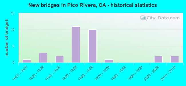
- New bridges - historical statistics
- 11920-1929
- 31930-1939
- 21940-1949
- 111950-1959
- 101960-1969
- 11970-1979
- 22000-2009
- 22010-2019

- Reconstructed bridges - Historical Statistics
- 21950-1959
- 11960-1969


- Bridge Condition - Deck
- 22.2%Good
- 22.2%Satisfactory
- 27.8%Fair
- 27.8%Poor

- Bridge Condition - Superstructure
- 66.7%Good
- 27.8%Satisfactory
- 5.6%Fair

- Bridge Condition - Substructure
- 77.8%Good
- 16.7%Satisfactory
- 5.6%Fair

- Bridge Condition - Channel
- 35.3%Excellent
- 23.5%Very good
- 23.5%Good
- 17.6%Satisfactory

- Bridge Condition - Culverts
- 50.0%Very good
- 50.0%Good
Find on map >> Show street view
Structure Number: 53 0534, Location: 07-LA-164-2.06 (Lat: 34.023967, Lng: -118.070617), Route carried "on" structure: State highway 164, Year Built: 1952, Status: Open, Structure Length: 8.99m (29.49ft), Average Daily Traffic: 45,900 (year 2021), Truck Traffic: 5%, Average Future Daily Traffic: 55,642 (year 2043), Design Load: HS 20, Features Intersected: FLOOD FLOW CHANNEL
Minimum Vertical Clearance: 30+ m (98+ ft), Kilometerpoint: 2.060, Lanes on structure: 4, Base Highway Network: Yes (Inventory Route: 1, Subroute: 1), Owner: State Highway Agency, Approaching Roadway Width: 20.7m (67.9ft), Skew: 20 degrees, Material/Design: Concrete, Design/Construction: Tee Beam, Number Of Spans In Main Unit: 5, Length of Maximum Span: 18.0m (59.1ft), Curb or Sidewalk Widths: Left: 1.3m (4.3ft), Right: 1.3m (4.3ft), Curb-To-Curb Width: 24.4m (80.1ft), Out-to-Out Width: 29.0m (95.1ft)
Condition: Deck: Good, Superstructure: Good, Substructure: Good, Channel: Satisfactory, Operating Rating: 66.4 metric tons, Method Used To Determine Operating Rating: Load Factor (LF), Inventory Rating: 39.9 metric tons, Method Used To Determine Inventory Rating: Load Factor (LF), Structural Evaluation: Better than present minimum criteria, Deck Geometry: Superior to present desirable criteria, Waterway Adequacy: Equal to present minimum criteria, Approach Roadway Alignment: Equal to present desirable criteria, Designated Inspection Frequency: Every 24 months, Inspection Date: January 2021, Deck Structure Type: Concrete Cast-file-Place
Find on map >> Show street view
Structure Number: 53 1533, Location: 07-LA-605-R15.57-PRV (Lat: 34.018100, Lng: -118.053144), Route carried "on" structure: City street Q651, Year Built: 1964, Status: Open, Structure Length: 7.17m (23.52ft), Average Daily Traffic: 9,450 (year 2015), Truck Traffic: 4%, Average Future Daily Traffic: 12,365 (year 2040), Design Load: HS 20, Features Intersected: INTERSTATE 605, Facility Carried by Structure: ROSE HILLS ROAD
Minimum Vertical Clearance: 30+ m (98+ ft), Kilometerpoint: 0.000, Lanes on structure: 4, Lanes under structure: 8, Owner: State Highway Agency, Approaching Roadway Width: 14.7m (48.2ft), Skew: 1 degrees, Material/Design: Concrete continuous, Design/Construction: Box Beam or Girders - Multiple, Number Of Spans In Main Unit: 4, Length of Maximum Span: 22.1m (72.5ft), Curb or Sidewalk Widths: Left: 1.8m (5.9ft), Right: 0.6m (2.0ft), Curb-To-Curb Width: 14.7m (48.2ft), Out-to-Out Width: 17.7m (58.1ft)
Condition: Deck: Good, Superstructure: Good, Substructure: Good, Operating Rating: 37.9 metric tons, Method Used To Determine Operating Rating: Load and Resistance Factor Rating (LRFR) rating reported by rating factor(RF) method using HL-93 loadings, Inventory Rating: 29.2 metric tons, Method Used To Determine Inventory Rating: Load and Resistance Factor Rating (LRFR) rating reported by rating factor(RF) method using HL-93 loadings, Structural Evaluation: Better than present minimum criteria, Deck Geometry: High priority of replacement, Underclear: Meets minimum limits, Approach Roadway Alignment: Equal to present desirable criteria, Designated Inspection Frequency: Every 24 months, Inspection Date: March 2020, Deck Structure Type: Concrete Cast-file-Place
Find on map >> Show street view
Structure Number: 53 1829, Location: 07-LA-605-R15.70-PRV (Lat: 34.018964, Lng: -118.050597), Route carried "on" structure: Interstate 605, Year Built: 1964, Status: Open, Structure Length: 1.28m (4.20ft), Average Daily Traffic: 251,000 (year 2015), Truck Traffic: 11%, Average Future Daily Traffic: 278,386 (year 2040), Design Load: HS 20, Features Intersected: SAN JOSE CREEK CHANNEL
Minimum Vertical Clearance: 30+ m (98+ ft), Kilometerpoint: 15.700, Lanes on structure: 12, Base Highway Network: Yes (Inventory Route: 6, Subroute: 3), Owner: State Highway Agency, Approaching Roadway Width: 51.6m (169.3ft), Skew: 35 degrees, Material/Design: Concrete continuous, Design/Construction: Culvert, Number Of Spans In Main Unit: 3, Length of Maximum Span: 4.3m (14.1ft), Curb-To-Curb Width: 51.6m (169.3ft), Out-to-Out Width: 74.0m (242.8ft)
Condition: Channel: Very good, Culverts: Good, Operating Rating: 54.1 metric tons, Method Used To Determine Operating Rating: Field evaluation and documented engineering judgment, Inventory Rating: 32.4 metric tons, Method Used To Determine Inventory Rating: Field evaluation and documented engineering judgment, Structural Evaluation: Better than present minimum criteria, Deck Geometry: Better than present minimum criteria, Waterway Adequacy: Equal to present desirable criteria, Approach Roadway Alignment: Equal to present desirable criteria, Designated Inspection Frequency: Every 24 months, Inspection Date: March 2020
Find on map >> Show street view
Structure Number: 53C0036, Location: 0.1MI W/O I-605 FWY (Lat: 34.005189, Lng: -118.064753), Route carried "on" structure: City street L363, Year Built: 1964, Status: Open, Structure Length: 4.15m (13.62ft), Average Daily Traffic: 5,034 (year 2012), Truck Traffic: 2%, Average Future Daily Traffic: 5,789 (year 2040), Design Load: HS 20, Features Intersected: UPRR, Facility Carried by Structure: BEVERLY BLVD
Minimum Vertical Clearance: 30.47m (99.97ft), Kilometerpoint: 0.000, Lanes on structure: 5, Owner: City or Municipal Highway Agency, Approaching Roadway Width: 20.7m (67.9ft), Skew: 22 degrees, Material/Design: Steel, Design/Construction: Stringer/Multi-beam, Number Of Spans In Main Unit: 3, Length of Maximum Span: 12.8m (42.0ft), Curb or Sidewalk Widths: Left: 1.4m (4.6ft), Right: 1.4m (4.6ft), Curb-To-Curb Width: 28.5m (93.5ft), Out-to-Out Width: 29.2m (95.8ft)
Condition: Deck: Fair, Superstructure: Satisfactory, Substructure: Good, Operating Rating: 86.8 metric tons, Method Used To Determine Operating Rating: Load Factor (LF), Inventory Rating: 51.8 metric tons, Method Used To Determine Inventory Rating: Load Factor (LF), Structural Evaluation: Equal to present minimum criteria, Deck Geometry: Superior to present desirable criteria, Underclear: Meets minimum limits, Approach Roadway Alignment: Equal to present desirable criteria, Designated Inspection Frequency: Every 24 months, Other Special Inspection Frequency: Every 48 months, Inspection Date: December 2020, Other Special Inspection Date: July 2020, Deck Structure Type: Concrete Cast-file-Place, Wearing Surface/Protective System: Wearing Surface: Monolithic Concrete
Find on map >> Show street view
Structure Number: 53C0052, Location: 0.1 MI SOUTH OF SR 110 (Lat: 34.102528, Lng: -118.196000), Route carried "on" structure: City street , Year Built: 1940, Status: Open, Structure Length: 1.90m (6.23ft), Average Daily Traffic: 5,370 (year 2005), Truck Traffic: 1%, Average Future Daily Traffic: 10,477 (year 2037), Design Load: H 15, Features Intersected: ARROYO SECO, Facility Carried by Structure: AVENUE 52
Minimum Vertical Clearance: 30+ m (98+ ft), Kilometerpoint: 0.000, Lanes on structure: 2, Owner: City or Municipal Highway Agency, Approaching Roadway Width: 10.4m (34.1ft), Skew: 1 degrees, Material/Design: Concrete, Design/Construction: Tee Beam, Number Of Spans In Main Unit: 1, Length of Maximum Span: 18.4m (60.4ft), Curb or Sidewalk Widths: Left: 1.5m (4.9ft), Right: 1.5m (4.9ft), Curb-To-Curb Width: 10.4m (34.1ft), Out-to-Out Width: 14.0m (45.9ft)
Condition: Deck: Good, Superstructure: Good, Substructure: Good, Channel: Excellent, Operating Rating: 54.8 metric tons, Method Used To Determine Operating Rating: Load Factor (LF), Inventory Rating: 33.0 metric tons, Method Used To Determine Inventory Rating: Load Factor (LF), Structural Evaluation: Better than present minimum criteria, Deck Geometry: Meets minimum limits, Waterway Adequacy: Superior to present desirable criteria, Approach Roadway Alignment: Equal to present desirable criteria, Designated Inspection Frequency: Every 48 months, Inspection Date: October 2018, Deck Structure Type: Concrete Cast-file-Place
Find on map >> Show street view
Structure Number: 53C0057, Location: 0.2MI W/O I-605 FWY (Lat: 33.950811, Lng: -118.094697), Route carried "on" structure: City street L165, Year Built: 1937, Status: Open, Structure Length: 12.90m (42.32ft), Average Daily Traffic: 44,300 (year 2016), Truck Traffic: 3%, Average Future Daily Traffic: 53,160 (year 2040), Design Load: H 15, Features Intersected: SAN GABRIEL RIV, Facility Carried by Structure: TELEGRAPH RD
Minimum Vertical Clearance: 30.47m (99.97ft), Kilometerpoint: 0.000, Lanes on structure: 4, Owner: City or Municipal Highway Agency, Approaching Roadway Width: 22.9m (75.1ft), Material/Design: Concrete continuous, Design/Construction: Tee Beam, Number Of Spans In Main Unit: 8, Length of Maximum Span: 19.2m (63.0ft), Curb or Sidewalk Widths: Left: 1.2m (3.9ft), Right: 1.2m (3.9ft), Curb-To-Curb Width: 13.2m (43.3ft), Out-to-Out Width: 16.4m (53.8ft)
Condition: Deck: Satisfactory, Superstructure: Good, Substructure: Good, Channel: Good, Operating Rating: 26.6 metric tons, Method Used To Determine Operating Rating: Load Factor (LF), Inventory Rating: 15.9 metric tons, Method Used To Determine Inventory Rating: Load Factor (LF), Structural Evaluation: High priority of corrective action, Deck Geometry: High priority of replacement, Waterway Adequacy: Better than present minimum criteria, Approach Roadway Alignment: Equal to present desirable criteria, Designated Inspection Frequency: Every 24 months, Inspection Date: December 2020, Deck Structure Type: Concrete Cast-file-Place, Wearing Surface/Protective System: Wearing Surface: Monolithic Concrete
Find on map >> Show street view
Structure Number: 53C0081, Location: 0.3MI N/O I-605 FWY (Lat: 34.006778, Lng: -118.069169), Route carried "on" structure: City street L363, Year Built: 1951, Status: Open, Structure Length: 11.92m (39.11ft), Average Daily Traffic: 5,084 (year 2012), Truck Traffic: 5%, Average Future Daily Traffic: 5,847 (year 2040), Design Load: HS 20, Features Intersected: SAN GABRIEL RIV, Facility Carried by Structure: BEVERLY BLVD
Minimum Vertical Clearance: 30.47m (99.97ft), Kilometerpoint: 0.000, Lanes on structure: 4, Owner: City or Municipal Highway Agency, Approaching Roadway Width: 19.2m (63.0ft), Material/Design: Concrete continuous, Design/Construction: Tee Beam, Number Of Spans In Main Unit: 6, Number Of Approach Spans: 2, Length of Maximum Span: 23.8m (78.1ft), Curb or Sidewalk Widths: Left: 1.4m (4.6ft), Right: 1.4m (4.6ft), Curb-To-Curb Width: 14.7m (48.2ft), Out-to-Out Width: 18.3m (60.0ft)
Condition: Deck: Fair, Superstructure: Good, Substructure: Satisfactory, Channel: Very good, Operating Rating: 53.8 metric tons, Method Used To Determine Operating Rating: Load Factor (LF), Inventory Rating: 32.4 metric tons, Method Used To Determine Inventory Rating: Load Factor (LF), Structural Evaluation: Equal to present minimum criteria, Deck Geometry: High priority of replacement, Waterway Adequacy: Equal to present desirable criteria, Approach Roadway Alignment: Equal to present desirable criteria, Designated Inspection Frequency: Every 24 months, Inspection Date: December 2020, Deck Structure Type: Concrete Cast-file-Place, Wearing Surface/Protective System: Wearing Surface: Integral Concrete
Find on map >> Show street view
Structure Number: 53C0082, Location: 0.2MI W/O I-605 FWY (Lat: 33.975472, Lng: -118.082756), Route carried "on" structure: City street L106, Year Built: 1953, Status: Open, Structure Length: 10.24m (33.60ft), Average Daily Traffic: 42,693 (year 2012), Truck Traffic: 5%, Average Future Daily Traffic: 51,232 (year 2040), Design Load: HS 20, Features Intersected: SAN GABRIEL RIV, Facility Carried by Structure: WASHINGTON BLVD
Minimum Vertical Clearance: 30.47m (99.97ft), Kilometerpoint: 0.000, Lanes on structure: 4, Owner: City or Municipal Highway Agency, Approaching Roadway Width: 14.6m (47.9ft), Material/Design: Concrete continuous, Design/Construction: Tee Beam, Number Of Spans In Main Unit: 5, Length of Maximum Span: 22.6m (74.1ft), Curb or Sidewalk Widths: Left: 1.4m (4.6ft), Right: 1.4m (4.6ft), Curb-To-Curb Width: 14.7m (48.2ft), Out-to-Out Width: 18.2m (59.7ft)
Condition: Deck: Satisfactory, Superstructure: Good, Substructure: Good, Channel: Good, Operating Rating: 56.4 metric tons, Method Used To Determine Operating Rating: Load Factor (LF), Inventory Rating: 33.7 metric tons, Method Used To Determine Inventory Rating: Load Factor (LF), Structural Evaluation: Better than present minimum criteria, Deck Geometry: High priority of replacement, Waterway Adequacy: Equal to present desirable criteria, Approach Roadway Alignment: Equal to present desirable criteria, Designated Inspection Frequency: Every 48 months, Inspection Date: December 2020, Deck Structure Type: Concrete Cast-file-Place, Wearing Surface/Protective System: Wearing Surface: Monolithic Concrete
Find on map >> Show street view
Structure Number: 53C0084, Location: 0.8MI W/O 605 FWY (Lat: 33.966658, Lng: -118.090156), Route carried "on" structure: City street L125, Year Built: 1958, Year Reconstructed: 1964, Status: Open, Structure Length: 19.81m (64.99ft), Average Daily Traffic: 30,000 (year 2014), Truck Traffic: 5%, Average Future Daily Traffic: 36,000 (year 2040), Design Load: HS 20, Features Intersected: SAN GAB R BNSF UPRR ATSF, Facility Carried by Structure: SLAUSON AVE
Minimum Vertical Clearance: 30.47m (99.97ft), Kilometerpoint: 0.000, Lanes on structure: 4, Owner: City or Municipal Highway Agency, Approaching Roadway Width: 15.8m (51.8ft), Skew: 21 degrees, Material/Design: Steel continuous, Design/Construction: Stringer/Multi-beam, Number Of Spans In Main Unit: 7, Length of Maximum Span: 32.3m (106.0ft), Curb or Sidewalk Widths: Left: 1.5m (4.9ft), Right: 1.5m (4.9ft), Curb-To-Curb Width: 15.8m (51.8ft), Out-to-Out Width: 19.4m (63.6ft)
Condition: Deck: Poor, Superstructure: Satisfactory, Substructure: Satisfactory, Channel: Satisfactory, Operating Rating: 43.4 metric tons, Method Used To Determine Operating Rating: Load Factor (LF), Inventory Rating: 26.2 metric tons, Method Used To Determine Inventory Rating: Load Factor (LF), Structural Evaluation: Equal to present minimum criteria, Deck Geometry: Meets minimum limits, Underclear: Meets minimum limits, Waterway Adequacy: Equal to present desirable criteria, Approach Roadway Alignment: Better than present minimum criteria, Designated Inspection Frequency: Every 24 months, Critical Feature Inspection Frequency: Every 24 months, Other Special Inspection Frequency: Every 48 months, Inspection Date: December 2020, Critical Feature Inspection Date: June 2021, Other Special Inspection Date: June 2021, Bridge Improvement Cost: $3,844,000, Roadway Improvement Cost: $768,000, Total Project Cost: $6,457,000 ( Estimate for 2021), Deck Structure Type: Concrete Cast-file-Place, Wearing Surface/Protective System: Wearing Surface: Monolithic Concrete
Find on map >> Show street view
Structure Number: 53C0087, Location: 0.3MI E/O I-5 FWY (Lat: 33.975517, Lng: -118.120053), Route carried "on" structure: City street L125, Year Built: 1954, Status: Open, Structure Length: 15.18m (49.80ft), Average Daily Traffic: 40,125 (year 2012), Truck Traffic: 15%, Average Future Daily Traffic: 48,150 (year 2040), Design Load: HS 20, Features Intersected: RIO HONDO, Facility Carried by Structure: SLAUSON AVE
Minimum Vertical Clearance: 30.47m (99.97ft), Kilometerpoint: 0.000, Lanes on structure: 4, Owner: City or Municipal Highway Agency, Approaching Roadway Width: 23.2m (76.1ft), Skew: 1 degrees, Material/Design: Concrete continuous, Design/Construction: Tee Beam, Number Of Spans In Main Unit: 6, Length of Maximum Span: 27.4m (89.9ft), Curb or Sidewalk Widths: Left: 1.4m (4.6ft), Right: 1.4m (4.6ft), Curb-To-Curb Width: 14.6m (47.9ft), Out-to-Out Width: 18.2m (59.7ft)
Condition: Deck: Poor, Superstructure: Satisfactory, Substructure: Good, Channel: Excellent, Operating Rating: 55.7 metric tons, Method Used To Determine Operating Rating: Load Factor (LF), Inventory Rating: 33.4 metric tons, Method Used To Determine Inventory Rating: Load Factor (LF), Structural Evaluation: Equal to present minimum criteria, Deck Geometry: High priority of replacement, Waterway Adequacy: Equal to present desirable criteria, Approach Roadway Alignment: Equal to present desirable criteria, Designated Inspection Frequency: Every 24 months, Inspection Date: December 2020, Deck Structure Type: Concrete Cast-file-Place, Wearing Surface/Protective System: Wearing Surface: Monolithic Concrete
Find on map >> Show street view
Structure Number: 53C0156, Location: 0.5MI W/O PARAMOUNT BLVD (Lat: 33.972422, Lng: -118.120622), Route carried "on" structure: City street L165, Year Built: 1951, Year Reconstructed: 1959, Status: Open, Structure Length: 15.85m (52.00ft), Average Daily Traffic: 24,717 (year 2012), Truck Traffic: 7%, Average Future Daily Traffic: 29,660 (year 2041), Design Load: HS 20, Features Intersected: RIO HONDO RIV, Facility Carried by Structure: TELEGRAPH RD
Minimum Vertical Clearance: 9.14m (29.99ft), Kilometerpoint: 0.000, Lanes on structure: 4, Owner: City or Municipal Highway Agency, Approaching Roadway Width: 18.3m (60.0ft), Material/Design: Steel, Design/Construction: Stringer/Multi-beam, Number Of Spans In Main Unit: 9, Length of Maximum Span: 24.4m (80.1ft), Curb or Sidewalk Widths: Left: 1.5m (4.9ft), Right: 1.5m (4.9ft), Curb-To-Curb Width: 14.6m (47.9ft), Out-to-Out Width: 18.7m (61.4ft)
Condition: Deck: Poor, Superstructure: Fair, Substructure: Good, Channel: Excellent, Operating Rating: 48.3 metric tons, Method Used To Determine Operating Rating: Load Factor (LF), Inventory Rating: 28.8 metric tons, Method Used To Determine Inventory Rating: Load Factor (LF), Structural Evaluation: Somewhat better than minimum adequacy, Deck Geometry: High priority of replacement, Waterway Adequacy: Equal to present desirable criteria, Approach Roadway Alignment: Better than present minimum criteria, Designated Inspection Frequency: Every 24 months, Inspection Date: January 2021, Deck Structure Type: Concrete Cast-file-Place, Wearing Surface/Protective System: Wearing Surface: Monolithic Concrete
Find on map >> Show street view
Structure Number: 53C041, Location: 0.6MI E/O VALLEY VIEW AVE (Lat: 33.873258, Lng: -118.019014), Route carried "on" structure: City street L090, Year Built: 1967, Status: Open, Structure Length: 3.23m (10.60ft), Average Daily Traffic: 19,698 (year 2012), Truck Traffic: 10%, Average Future Daily Traffic: 23,638 (year 2041), Design Load: HS 20+Mod, Features Intersected: COYOTE CRK, Facility Carried by Structure: ARTESIA BLVD
Minimum Vertical Clearance: 30.47m (99.97ft), Kilometerpoint: 0.000, Lanes on structure: 6, Owner: City or Municipal Highway Agency, Approaching Roadway Width: 25.6m (84.0ft), Skew: 2 degrees, Material/Design: Prestressed concrete, Design/Construction: Stringer/Multi-beam, Number Of Spans In Main Unit: 1, Length of Maximum Span: 31.7m (104.0ft), Curb or Sidewalk Widths: Left: 1.5m (4.9ft), Right: 1.5m (4.9ft), Curb-To-Curb Width: 27.5m (90.2ft), Out-to-Out Width: 29.3m (96.1ft)
Condition: Deck: Fair, Superstructure: Good, Substructure: Good, Channel: Excellent, Operating Rating: 51.2 metric tons, Method Used To Determine Operating Rating: Load Factor (LF), Inventory Rating: 31.1 metric tons, Method Used To Determine Inventory Rating: Load Factor (LF), Structural Evaluation: Better than present minimum criteria, Deck Geometry: Better than present minimum criteria, Waterway Adequacy: Superior to present desirable criteria, Approach Roadway Alignment: Equal to present desirable criteria, Designated Inspection Frequency: Every 24 months, Inspection Date: June 2021, Deck Structure Type: Concrete Cast-file-Place
Find on map >> Show street view
Structure Number: 53C0471, Location: 0.4MI W/O PARAMOUNT BLVD (Lat: 33.991222, Lng: -118.110153), Route carried "on" structure: City street L106, Year Built: 1941, Year Reconstructed: 1966, Status: Open, Structure Length: 14.75m (48.39ft), Average Daily Traffic: 33,974 (year 2012), Truck Traffic: 20%, Average Future Daily Traffic: 40,768 (year 2040), Features Intersected: RIO HONDO, Facility Carried by Structure: WASHINGTON BLVD
Minimum Vertical Clearance: 30.47m (99.97ft), Kilometerpoint: 0.000, Lanes on structure: 6, Owner: City or Municipal Highway Agency, Approaching Roadway Width: 21.3m (69.9ft), Skew: 20 degrees, Material/Design: Concrete continuous, Design/Construction: Tee Beam, Number Of Spans In Main Unit: 5, Length of Maximum Span: 33.5m (109.9ft), Curb or Sidewalk Widths: Left: 1.3m (4.3ft), Right: 1.3m (4.3ft), Curb-To-Curb Width: 21.3m (69.9ft), Out-to-Out Width: 29.0m (95.1ft)
Condition: Deck: Poor, Superstructure: Satisfactory, Substructure: Satisfactory, Channel: Excellent, Operating Rating: 41.8 metric tons, Method Used To Determine Operating Rating: Load Factor (LF), Inventory Rating: 24.9 metric tons, Method Used To Determine Inventory Rating: Load Factor (LF), Structural Evaluation: Equal to present minimum criteria, Deck Geometry: High priority of replacement, Waterway Adequacy: Equal to present desirable criteria, Approach Roadway Alignment: Equal to present desirable criteria, Designated Inspection Frequency: Every 24 months, Other Special Inspection Frequency: Every 48 months, Inspection Date: December 2020, Other Special Inspection Date: June 2020, Bridge Improvement Cost: $4,277,000, Roadway Improvement Cost: $3,418,000, Total Project Cost: $28,712,000 ( Estimate for 2017), Deck Structure Type: Concrete Cast-file-Place, Wearing Surface/Protective System: Wearing Surface: Monolithic Concrete
Find on map >> Show street view
Structure Number: 53C1417L, Location: 0.6MI N/O BEVERLY BLVD (Lat: 34.013678, Lng: -118.063325), Route carried "on" structure: City street M822, Year Built: 1954, Status: Open, Structure Length: 12.98m (42.59ft), Average Daily Traffic: 11,088 (year 2012), Truck Traffic: 3%, Average Future Daily Traffic: 12,751 (year 2040), Design Load: HS 20, Features Intersected: SAN GABRIEL RIV, Facility Carried by Structure: SAN GABRIEL RIV PK
Minimum Vertical Clearance: 30.47m (99.97ft), Kilometerpoint: 0.000, Lanes on structure: 2, Owner: City or Municipal Highway Agency, Approaching Roadway Width: 15.2m (49.9ft), Skew: 3 degrees, Material/Design: Concrete continuous, Design/Construction: Tee Beam, Number Of Spans In Main Unit: 6, Length of Maximum Span: 23.5m (77.1ft), Curb or Sidewalk Widths: Left: 1.3m (4.3ft), Right: 0.0m, Curb-To-Curb Width: 11.4m (37.4ft), Out-to-Out Width: 13.5m (44.3ft)
Condition: Deck: Satisfactory, Superstructure: Good, Substructure: Good, Channel: Good, Operating Rating: 69.3 metric tons, Method Used To Determine Operating Rating: Load Factor (LF), Inventory Rating: 41.5 metric tons, Method Used To Determine Inventory Rating: Load Factor (LF), Structural Evaluation: Better than present minimum criteria, Deck Geometry: Equal to present minimum criteria, Waterway Adequacy: Better than present minimum criteria, Approach Roadway Alignment: Equal to present desirable criteria, Designated Inspection Frequency: Every 48 months, Inspection Date: December 2020, Deck Structure Type: Concrete Cast-file-Place, Wearing Surface/Protective System: Wearing Surface: Monolithic Concrete
Find on map >> Show street view
Structure Number: 53C1417R, Location: 0.6MI N/O BEVERLY BLVD (Lat: 34.013561, Lng: -118.063467), Route carried "on" structure: City street M822, Year Built: 1954, Status: Open, Structure Length: 12.98m (42.59ft), Average Daily Traffic: 11,088 (year 2012), Truck Traffic: 3%, Average Future Daily Traffic: 12,751 (year 2040), Design Load: HS 20, Features Intersected: SAN GABRIEL RIV PKWAY, Facility Carried by Structure: SAN GABRIEL RIV PK
Minimum Vertical Clearance: 30.47m (99.97ft), Kilometerpoint: 0.000, Lanes on structure: 2, Owner: City or Municipal Highway Agency, Approaching Roadway Width: 15.2m (49.9ft), Skew: 3 degrees, Material/Design: Concrete continuous, Design/Construction: Tee Beam, Number Of Spans In Main Unit: 6, Length of Maximum Span: 23.5m (77.1ft), Curb or Sidewalk Widths: Left: 0.0m, Right: 1.3m (4.3ft), Curb-To-Curb Width: 11.4m (37.4ft), Out-to-Out Width: 13.5m (44.3ft)
Condition: Deck: Fair, Superstructure: Good, Substructure: Good, Channel: Good, Operating Rating: 69.3 metric tons, Method Used To Determine Operating Rating: Load Factor (LF), Inventory Rating: 41.5 metric tons, Method Used To Determine Inventory Rating: Load Factor (LF), Structural Evaluation: Better than present minimum criteria, Deck Geometry: Equal to present minimum criteria, Waterway Adequacy: Better than present minimum criteria, Approach Roadway Alignment: Equal to present desirable criteria, Designated Inspection Frequency: Every 24 months, Inspection Date: December 2020, Deck Structure Type: Concrete Cast-file-Place, Wearing Surface/Protective System: Wearing Surface: Monolithic Concrete
Find on map >> Show street view
Structure Number: 53C1432, Location: 1MI N/O BEVERLY BLVD (Lat: 34.014286, Lng: -118.057344), Route carried "on" structure: City street M822, Year Built: 1954, Status: Open, Structure Length: 1.46m (4.79ft), Average Daily Traffic: 11,088 (year 2012), Truck Traffic: 5%, Average Future Daily Traffic: 12,751 (year 2040), Design Load: HS 20, Features Intersected: SYCAMORE CYN CHAN, Facility Carried by Structure: SN GABRIEL RV PKWY
Minimum Vertical Clearance: 30.47m (99.97ft), Kilometerpoint: 0.000, Lanes on structure: 4, Owner: City or Municipal Highway Agency, Approaching Roadway Width: 20.7m (67.9ft), Skew: 20 degrees, Material/Design: Concrete continuous, Design/Construction: Slab, Number Of Spans In Main Unit: 2, Length of Maximum Span: 7.0m (23.0ft), Curb-To-Curb Width: 20.7m (67.9ft), Out-to-Out Width: 32.6m (107.0ft)
Condition: Deck: Satisfactory, Superstructure: Satisfactory, Substructure: Good, Channel: Satisfactory, Operating Rating: 52.2 metric tons, Method Used To Determine Operating Rating: Load Factor (LF), Inventory Rating: 31.1 metric tons, Method Used To Determine Inventory Rating: Load Factor (LF), Structural Evaluation: Equal to present minimum criteria, Deck Geometry: Superior to present desirable criteria, Waterway Adequacy: Equal to present minimum criteria, Approach Roadway Alignment: Equal to present desirable criteria, Designated Inspection Frequency: Every 24 months, Inspection Date: November 2020, Deck Structure Type: Concrete Cast-file-Place, Wearing Surface/Protective System: Wearing Surface: Monolithic Concrete
Find on map >> Show street view
Structure Number: 53C1622, Location: 0.2MI N/O MISSION MILL RD (Lat: 34.020103, Lng: -118.047450), Route carried "on" structure: County highway , Year Built: 1966, Status: Open, Structure Length: 1.16m (3.81ft), Average Daily Traffic: 330 (year 2012), Truck Traffic: 2%, Average Future Daily Traffic: 330 (year 2040), Features Intersected: OLD SAN JOSE CRK, Facility Carried by Structure: BAYBAR RD
Minimum Vertical Clearance: 30.47m (99.97ft), Kilometerpoint: 0.000, Lanes on structure: 2, Owner: City or Municipal Highway Agency, Approaching Roadway Width: 7.3m (24.0ft), Skew: 4 degrees, Material/Design: Concrete, Design/Construction: Culvert, Number Of Spans In Main Unit: 3, Length of Maximum Span: 2.4m (7.9ft)
Condition: Channel: Excellent, Culverts: Very good, Operating Rating: 40.5 metric tons, Method Used To Determine Operating Rating: Field evaluation and documented engineering judgment, Inventory Rating: 24.3 metric tons, Method Used To Determine Inventory Rating: Field evaluation and documented engineering judgment, Structural Evaluation: Equal to present minimum criteria, Waterway Adequacy: Superior to present desirable criteria, Approach Roadway Alignment: Better than present minimum criteria, Designated Inspection Frequency: Every 24 months, Inspection Date: November 2020
Find on map >> Show street view
Structure Number: 53C2182L, Location: 2MI E/O SIERRA HWY (Lat: 34.558425, Lng: -118.097069), Route carried "on" structure: City street , Year Built: 2007, Status: Open, Structure Length: 8.26m (27.10ft), Average Daily Traffic: 28,154 (year 2012), Truck Traffic: 1%, Average Future Daily Traffic: 33,784 (year 2040), Design Load: HS 20+Mod, Features Intersected: RR, Facility Carried by Structure: AVE S W
Minimum Vertical Clearance: 30.47m (99.97ft), Kilometerpoint: 0.000, Lanes on structure: 2, Owner: City or Municipal Highway Agency, Approaching Roadway Width: 12.1m (39.7ft), Skew: 6 degrees, Material/Design: Concrete continuous, Design/Construction: Box Beam or Girders - Single/Spread, Number Of Spans In Main Unit: 3, Length of Maximum Span: 39.1m (128.3ft), Curb or Sidewalk Widths: Left: 1.5m (4.9ft), Right: 0.0m, Curb-To-Curb Width: 11.9m (39.0ft), Out-to-Out Width: 14.2m (46.6ft)
Condition: Deck: Poor, Superstructure: Good, Substructure: Good, Operating Rating: 99.8 metric tons, Method Used To Determine Operating Rating: Load Factor (LF), Inventory Rating: 59.6 metric tons, Method Used To Determine Inventory Rating: Load Factor (LF), Structural Evaluation: Better than present minimum criteria, Deck Geometry: Better than present minimum criteria, Underclear: Equal to present minimum criteria, Approach Roadway Alignment: Equal to present desirable criteria, Designated Inspection Frequency: Every 24 months, Inspection Date: May 2020, Deck Structure Type: Concrete Cast-file-Place
Find on map >> Show street view
Structure Number: 53C2191, Location: 0.4MI W/O PARAMOUNT BLVD (Lat: 34.014203, Lng: -118.092969), Route carried "on" structure: City street , Year Built: 2009, Status: Open, Structure Length: 16.88m (55.38ft), Average Daily Traffic: 37,418 (year 2012), Truck Traffic: 1%, Average Future Daily Traffic: 44,902 (year 2040), Design Load: HS 20, Features Intersected: RIO HONDO CHAN, Facility Carried by Structure: BEVERLY BLVD
Minimum Vertical Clearance: 30.47m (99.97ft), Kilometerpoint: 0.000, Lanes on structure: 5, Owner: City or Municipal Highway Agency, Approaching Roadway Width: 25.3m (83.0ft), Skew: 2 degrees, Material/Design: Prestressed concrete, Design/Construction: Box Beam or Girders - Multiple, Number Of Spans In Main Unit: 6, Length of Maximum Span: 31.3m (102.7ft), Curb or Sidewalk Widths: Left: 1.9m (6.2ft), Right: 1.9m (6.2ft), Curb-To-Curb Width: 24.2m (79.4ft), Out-to-Out Width: 28.1m (92.2ft)
Condition: Deck: Fair, Superstructure: Good, Substructure: Good, Channel: Very good, Operating Rating: 54.1 metric tons, Method Used To Determine Operating Rating: Field evaluation and documented engineering judgment, Inventory Rating: 32.4 metric tons, Method Used To Determine Inventory Rating: Field evaluation and documented engineering judgment, Structural Evaluation: Better than present minimum criteria, Deck Geometry: Superior to present desirable criteria, Waterway Adequacy: Equal to present desirable criteria, Approach Roadway Alignment: Equal to present desirable criteria, Designated Inspection Frequency: Every 24 months, Inspection Date: December 2020, Deck Structure Type: Concrete Cast-file-Place
Find on map >> Show street view
Structure Number: 53C2335, Location: 0.5 MI E/O 50TH ST EAST (Lat: 34.690000, Lng: -118.025000), Route carried "on" structure: City street _, Year Built: 2015, Status: Open, Structure Length: 3.17m (10.40ft), Average Daily Traffic: 3,513 (year 2012), Truck Traffic: 2%, Average Future Daily Traffic: 3,864 (year 2041), Design Load: HL 93, Features Intersected: LITTLE ROCK CREEK, Facility Carried by Structure: AVENUE J
Minimum Vertical Clearance: 30.47m (99.97ft), Kilometerpoint: 0.000, Lanes on structure: 2, Owner: County Highway Agency, Approaching Roadway Width: 12.8m (42.0ft), Skew: 3 degrees, Material/Design: Concrete, Design/Construction: Slab, Number Of Spans In Main Unit: 3, Length of Maximum Span: 12.2m (40.0ft), Curb-To-Curb Width: 12.8m (42.0ft), Out-to-Out Width: 13.5m (44.3ft)
Condition: Deck: Good, Superstructure: Good, Substructure: Fair, Channel: Very good, Operating Rating: 42.1 metric tons, Method Used To Determine Operating Rating: Assigned ratings based on Load and Resistance Factor Design (LRFD) reported by rating factor (RF) using HL93 loadings, Inventory Rating: 32.4 metric tons, Method Used To Determine Inventory Rating: Assigned ratings based on Load and Resistance Factor Design (LRFD) reported by rating factor (RF) using HL93 loadings, Structural Evaluation: Somewhat better than minimum adequacy, Deck Geometry: Equal to present minimum criteria, Waterway Adequacy: Equal to present desirable criteria, Approach Roadway Alignment: Equal to present desirable criteria, Designated Inspection Frequency: Every 24 months, Inspection Date: Febuary 2022, Deck Structure Type: Concrete Cast-file-Place, Wearing Surface/Protective System: Wearing Surface: Monolithic Concrete
Find on map >> Show street view
Structure Number: 53 1415, Location: 07-LA-605-R14.08-PRV (Lat: 34.001006, Lng: -118.067439), Route carried "under" structure: Interstate 605, Year Built: 1964, Structure Length: 0. m, Average Daily Traffic: 251,000 (year 2012), Truck Traffic: 11%, Features Intersected: INTERSTATE 605, Facility Carried by Structure: UP RR
Minimum Vertical Clearance: 5.21m (17.09ft), Kilometerpoint: 14.080, Lanes under structure: 9, Material/Design: Steel, Design/Construction: Girder and Floorbeam System, Length of Maximum Span: 38.4m (126.0ft)
Find on map >> Show street view
Structure Number: 53 1531, Location: 07-LA-605-R14.41-PRV (Lat: 34.004567, Lng: -118.064314), Route carried "under" structure: Interstate 605, Year Built: 1964, Structure Length: 0. m, Average Daily Traffic: 271,500 (year 2012), Truck Traffic: 13%, Features Intersected: INTERSTATE 605, Facility Carried by Structure: BEVERLY BLVD
Minimum Vertical Clearance: 5.05m (16.57ft), Kilometerpoint: 14.410, Lanes on structure: 4, Lanes under structure: 11, Material/Design: Concrete continuous, Design/Construction: Box Beam or Girders - Multiple, Length of Maximum Span: 24.4m (80.1ft)
Find on map >> Show street view
Structure Number: 53 1531, Location: 07-LA-605-R14.41-PRV (Lat: 34.004567, Lng: -118.064314), Route carried "under" structure: Ramp Interstate 605, Year Built: 1964, Structure Length: 0. m, Average Daily Traffic: 27,100 (year 2012), Truck Traffic: 3%, Features Intersected: INTERSTATE 605, Facility Carried by Structure: BEVERLY BLVD
Minimum Vertical Clearance: 4.82m (15.81ft), Kilometerpoint: 14.410, Lanes on structure: 4, Lanes under structure: 1, Material/Design: Concrete continuous, Design/Construction: Box Beam or Girders - Multiple, Length of Maximum Span: 24.4m (80.1ft)
Find on map >> Show street view
Structure Number: 53 1531, Location: 07-LA-605-R14.41-PRV (Lat: 34.004567, Lng: -118.064314), Route carried "under" structure: Ramp Interstate 605, Year Built: 1964, Structure Length: 0. m, Average Daily Traffic: 27,100 (year 2012), Truck Traffic: 3%, Features Intersected: INTERSTATE 605, Facility Carried by Structure: BEVERLY BLVD
Minimum Vertical Clearance: 4.93m (16.17ft), Kilometerpoint: 14.410, Lanes on structure: 4, Lanes under structure: 2, Material/Design: Concrete continuous, Design/Construction: Box Beam or Girders - Multiple, Length of Maximum Span: 24.4m (80.1ft)
Find on map >> Show street view
Structure Number: 53 1533, Location: 07-LA-605-R15.57-PRV (Lat: 34.018100, Lng: -118.053144), Route carried "under" structure: Interstate 605, Year Built: 1964, Structure Length: 0. m, Average Daily Traffic: 271,500 (year 2015), Truck Traffic: 13%, Features Intersected: INTERSTATE 605, Facility Carried by Structure: ROSE HILLS ROAD
Minimum Vertical Clearance: 5.28m (17.32ft), Kilometerpoint: 15.570, Lanes on structure: 4, Lanes under structure: 8, Material/Design: Concrete continuous, Design/Construction: Box Beam or Girders - Multiple, Length of Maximum Span: 22.1m (72.5ft)
Find on map >> Show street view
Structure Number: 53C0192, Location: 0.6MI S/O WASHINGTON BLVD (Lat: 33.978967, Lng: -118.110514), Route carried "under" structure: City street L091, Year Built: 1958, Structure Length: 0. m, Average Daily Traffic: 22,684 (year 2012), Truck Traffic: 10%, Features Intersected: PARAMOUNT BLVD, Facility Carried by Structure: ATSF RR
Minimum Vertical Clearance: 4.57m (14.99ft), Kilometerpoint: 0.000, Lanes under structure: 4, Material/Design: Concrete continuous, Design/Construction: Slab, Length of Maximum Span: 12.8m (42.0ft)
Find on map >> Show street view
Structure Number: 53C0418, Location: 0.1MI N/O WHITTIER BLVD (Lat: 34.004789, Lng: -118.088203), Route carried "under" structure: City street L091, Year Built: 1972, Structure Length: 0. m, Average Daily Traffic: 14,832 (year 2012), Truck Traffic: 3%, Features Intersected: PARAMOUNT BLVD, Facility Carried by Structure: UP RR
Minimum Vertical Clearance: 4.75m (15.58ft), Kilometerpoint: 0.000, Lanes under structure: 4, Material/Design: Steel, Design/Construction: Stringer/Multi-beam, Length of Maximum Span: 14.9m (48.9ft)
Find on map >> Show street view
Structure Number: 53C2187, Location: 0.5MI N/O WASHINGTON BLVD (Lat: 33.989264, Lng: -118.092981), Route carried "under" structure: City street , Year Built: 1958, Structure Length: 0. m, Average Daily Traffic: 24,960 (year 2012), Truck Traffic: 1%, Features Intersected: ROSEMEAD BOULEVARD, Facility Carried by Structure: BALFOUR ST POC
Minimum Vertical Clearance: 4.60m (15.09ft), Kilometerpoint: 0.000, Lanes under structure: 4, Material/Design: Concrete, Design/Construction: Slab, Length of Maximum Span: 14.9m (48.9ft)
Find on map >> Show street view
Structure Number: 53C2189, Location: 0.2MI N/O WHITTIER BLVD (Lat: 34.003811, Lng: -118.083514), Route carried "under" structure: City street , Year Built: 1938, Structure Length: 0. m, Average Daily Traffic: 30,456 (year 2012), Truck Traffic: 4%, Features Intersected: ROSEMEAD BOULEVARD, Facility Carried by Structure: METROLINK
Minimum Vertical Clearance: 4.52m (14.83ft), Kilometerpoint: 0.000, Lanes under structure: 4, Material/Design: Steel, Design/Construction: Girder and Floorbeam System, Length of Maximum Span: 21.9m (71.9ft)
Find on map >> Show street view
Structure Number: 53C219, Location: 0.3MI N/O SLAUSON AVE (Lat: 33.974125, Lng: -118.103428), Route carried "under" structure: City street , Year Built: 1937, Structure Length: 0. m, Average Daily Traffic: 25,920 (year 2012), Truck Traffic: 4%, Features Intersected: ROSEMEAD BOULEVARD, Facility Carried by Structure: BNSF
Minimum Vertical Clearance: 4.50m (14.76ft), Kilometerpoint: 13.299, Lanes under structure: 4, Material/Design: Steel, Design/Construction: Girder and Floorbeam System, Length of Maximum Span: 23.5m (77.1ft)
Find on map >> Show street view
Structure Number: 53C2303, Location: 0.3MI W/O PARAMOUNT BLVD (Lat: 34.005075, Lng: -118.092758), Route carried "under" structure: City street , Year Built: 1926, Structure Length: 0. m, Average Daily Traffic: 44,100 (year 2010), Features Intersected: WHITTIER BLVD, Facility Carried by Structure: UPRR AND MTA
Minimum Vertical Clearance: 4.55m (14.93ft), Kilometerpoint: 0.000, Lanes under structure: 4, Material/Design: Steel, Design/Construction: Girder and Floorbeam System, Length of Maximum Span: 22.6m (74.1ft)
Find on map >> Show street view
Structure Number: 53C2332, Location: 350FT N/O SLAUSON AVE (Lat: 33.970000, Lng: -118.106111), Route carried "under" structure: City street , Year Built: 2013, Structure Length: 0. m, Average Daily Traffic: 8,451 (year 2014), Truck Traffic: 1%, Features Intersected: PASSONS BLVD, Facility Carried by Structure: UPRR
Minimum Vertical Clearance: 5.05m (16.57ft), Kilometerpoint: 0.000, Lanes under structure: 4, Material/Design: Steel, Design/Construction: Girder and Floorbeam System, Length of Maximum Span: 12.8m (42.0ft)